
Donuts Rule Everything Around Me - Gravel Cyclists at their worst which is the best !!!!
Don't wanna be here? Send us removal request.
Statistics
We looked inside some of the posts by donuts-rule-everything-arou-blog and here's what we found interesting.
Average Info
Notes Per Post
0
Likes Per Post
0
Reblog Per Post
0
Reply Per Post
0
Time Between Posts
9 days
Number of Posts By Type
Photo
9
Video
1
Last Seen Tumblr Blogs


Fun Fact
When “GIF” was named word of the year in 2012, Oxford Dictionaries U.S.A. credited Tumblr for pushing the word.
Photo

Well I can't re invent the wheel but I can break my chain n go for a ride! (Some much needed steady state at low intensity) Should do for now but anyone wanna venture how many times I will lose my chain between now n payday 😂😂!
0 notes
Photo

I get glazy when I stare into your eyes. D.R.E.A.M Team post ride Nutrition. (at Smalls Coffee)
0 notes
Photo

Written by Ellise Gravel so you don't say?
0 notes
Photo

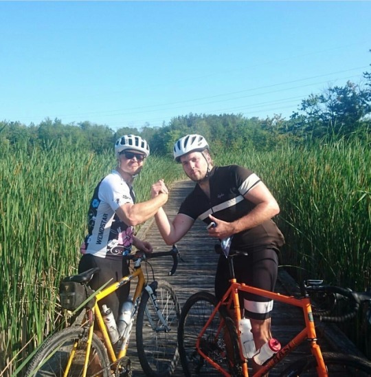
Only in Montreal would I find my dream girl !!! (at Montreal, Quebec)
0 notes
Video
Great Tour of Montreal's cycling infrastructure by @leschachter & even a little gravel! (at Montreal, Quebec)
0 notes
Photo

You can't take mountain out of the man! A little taste of NS in Montreal #bornnraised #novascotian #wildmountainman (at St. Henri)
0 notes
Photo

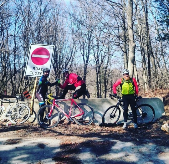
Hey there folks! Here is the first on many gravel routes originating from the Hamilton/Dundas area for your riding pleasure. This route originally began with Jamie Murrays idea to go to Paris for some Apple Fritters and so forth thus “3 the Hard Way” evolved based on the fact we needed to stop at Monigrams for donuts as well. D.R.E.A.M Team reigns supreme! https://www.strava.com/routes/10047260 Okay first and foremost all rides start and end and Grupetto Cycling Cafe (64 Hatt Street) in beautiful downtown Dundas That is our non written rule and we encourage you to do the same! Unless of course clause “I need caffeine and nothing else is open” takes effect in which case it is Stabucks. Which is close in distance to Grupetto but a little further in taste. Which of course falls under the elusive D.R.E.A.M Constitutional by-laws
Okay so this is a big one and not for the faint of heart. This loop is 53% road, 42% Gravel and 5% double track or “rough stuff”. If you want something easy than I just suggest you take the easier rail trail route. Now please listen carefully to these instructions as there are some sections you may wish to by-pass and there are some navigational instructions that are pretty crucial. Also please take 3 bottles of water to start. It is about 80 km before you have access to purchasing water. Here is the legend G= Gravel: Generally dirt roads and wider commuter paths like the rail trail P= Pavement DT= Double Track : The rough stuff that is mtb worthy I have broken this down into sections based on the area and surface types. Please refer to the Strava route map for direction. I will try to include any small details in terms of navigation that a GPS device wont help you with. A) P= A gradual climb up Wilson Street via Dundas and down into Sulphur Springs/ Mineral Springs Road. **This is a very gradual climb but long and be prepared to stop just following the descent to enter the Headwaters Trail into the Dundas Valley.*** 12 km with 172 m of elevation gain B) This has a little bit of everything in it. You enter and climb up the Dundas Valley than descend back into it towards Middleton Road. Note there is some challenging gravel climbs in here! DT= Headwaters Trail to Martin Road: **You take a right on the bridge than a left up a hill by an information sign than be prepared for a right turn in mid descent which takes you over a bridge and you should come out on Martin Road (the finish line of the P2A Race)**** 1.6 km with 46 meters of elevation gain. G= Martin Road to Jerseyville Road: This is the finish line for the Paris to Ancaster Race which is a fairly challenging gravel climb. It brings you out behind the Ancaster Rotary Center which connects to Jerseyville Road. 0.5 km with 41 meters of elevation gain P= Jerseyville Road to Paddys Greene Road: Quick paved section 2.4 km with 23 meters of climbing G= Paddys Greene Road/Slote Road and Mineral Springs Road: A fast gravel section with little bit of climbing at the start. Its fun to blast this 4.7 km with 42 meters of climbing P = Binkley Road: Fast rolling paved section 1.1 km with 7 meters of elevation gain C) This is a fairly straight section that goes up Middleton Road to the bottom of the Lafarge 2000 Trail. It starts off with a rough gravel descent and flattens out with some very fast rolling gravel and pavement sections. G= Middleton Road: As you cross over Governors Road Binkley turns into Middleton Road. You will know you are going in the right direction because the first part of the road is closed to cars and blocked off. ***Be careful descending the road is super loose and often has washouts**** This is followed by a good sized climb that is turns into pavement. 0.9 km with 44m of elevation gain. G & P= Middleton Road to Lafarge 2000 Trail: This is a combination of pavement and crushed stone and gravel. It starts with a fairly descent climb and than flattens out taking you to the bottom of Lafarge Trail. 9.1 km with 70 meters of elevation gain. D) Lafarge 2000 Trail: This is double track with some really hard climbs, challenging, descents and has lots of potential washout spots and rough sections. Use caution on this! It starts at Concession 6 and ends at Gore Road. The first section has some brutal climbs that realistically 95 % of people dont make it up because it is technical and requires some serious fitness. There is no shame in running up many do. If you wish to by pass this section of the trail do this ****turn right of Concession 6 than left of Brock Road than an other left of Safari Road which you turn right onto Middleton Road which turns back in to the trail.
DT= Lafarge 2000 Trail Concession 6 to Safari Road: This first section is better known as the “Drumlins of Death”If you have the technical skills to even get up as wash outs and loose gravel is a factor you better make sure you have the fitness and power. There are some pretty twisty downhills of loose gravel. Please see by pass above ^. 2km with 75 meters of painful climbing P = Safari Road to Concession 8/Lafarge Trail: Rolling paved sections with a few climbs. ***You take a quick right on Concession 8 than a the first left to re-enter the Lafarge Trail*** 2.3 km with 63 meters of elevation gain DT= The next section of Lafarge is fairly fast ***minus the rock garden you roll down to access it***. This is where tubeless tires are suggested “Pinch”. Be careful on the line of choice. 1.8 km with 17 meters of elevation gain P= Just a quick connector section keep straight up the hill! .4 km with 16 m of elevation gain DT= This is the last part of Lafarge which is really beautiful ! It has some fairly twisty descents with possibility of having some washed-out sections. Dont be too gun heavy! It also has some climbs and crosses a marsh on a bridge. You end up on Gore Road. 2.6 km with 57 meters of elevation gain E) This next section goes along Gore Road towards Cambridge with a few turn for some fairly fast rolling gravel roads. There is a bit of climbing going up towards Concession 2 but you make up for it with the return to Gore Road via Side Road 10. P= Gore Road 3.4 km with 6 meters of elevation gain G= Concession 7 is a fast rolling gravel road with some climbing 4.3 km with 72 meters of climbing
P= Concession 2 is a relatively flat fast rolling paved section that goes along a construction quarry towards Cambridge 7.2 km with 28 meters of elevation gain G= Side Road 10 is a gravel road that has a gradual descent. This is a great spot to try to make good time! 3.9 km with 3 meters of climbing
F) The next section is the biggest paved section of the ride which brings you into Cambridge for a rest stop and brings you to the start of a very fun fast gravel loop in the Cambridge/Paris area. Cambridge has two very nice coffee spots that are located very close to each other. Monigrams ,16 Ainslie St. South, just before the bridge and Grand River and Grand Cafe, 18 Queens Square, just after the bridge. Also stock up of water because after this you will be “out there” until you return to Dundas. There are also a few hills to climb. Please refer to the Strava route for the specifics
21.5 km with 174 meters of elevation gain. G) This next section is a gravel route that we did on the “Tour de Grande”. It has little bit of everything and tons of fun fast rolling gravel sections. G= Brant/Waterloo and Shouldice Side Road is fast rolling quick gravel section 2.1 km with 4 meters of elevation gain P= Beke and Wrigley Road is a connecting pavement section that brings you to the start of a pretty epic gravel section. 6.6 km with 31 meters of climbing
G= This next gravel section which includes Reidsville Road, Brant/Waterloo, Nith Road, West Dumpfries Road and West River Road is so fun and beautiful it will make your head spin faster than your wheels. It is has rolling hills with some climbing. 18.6 km with 140 meters of elevation gain P= Glen Morris Road brings you to the next epic gravel section it is slight downhill with a climb at the end. 3.4 km with 34 meter of elevation gain
H) Yet an other epic gravel section! Sorry to put you through such torture! P & G= Princess Street turns into McPherson School Road this involves some subtle climbing and rolling sections. 3.4 km with 39 meters of elevation gain
G= McLeans School Road is a rolling gravel road with some small climbs that tapers out to pavement before turning down Burts Road. 7.7 km with 56 meters of elevation gain P= McLeans Road a connecting flat section to Burts Road.
1 km 6 meters G= Burt's Road is a two part gravel section that goes from a gravel road to and blocked off fire road. The first part is a quick gravel road with slight climb. 2.9 km with 20 meters of climbing. P= Just a quick left and right jaunt to connect Burts Road. 0.5 km DT- This section of Burts Road is only accessible by vehicle from the German School Road Side. It is fairly technical as the only vehicles suggested on it would be off road vehicles and farm equipment. **As you descend down the entry road to Burts curb your speed wisely before the bottom for there is a connecting ditch to the bridge which I suggest taking a slow speed if you do not wish to crash.*** 2.2 km with 30 meters of climbing I) This next paved section return you to the Hamilton/Brantford Rail Trail via some flat and rolling paved sections
P= Please refer to the Strava map for more specif instructions. 13.1 km with 90 meters of elevation gain G= This section is the Rail Trail which is a gradual descent and can be taken quite fast but slow down for the gates please the last thing we want on the end of a ride is collide with a steel gate. Do a quick turn onto Mineral Springs Road from the RT and one the right there is a climb up Gravel Pit Road which leads to an other climb (which is even harder hehehe). If you have had enough at this point and you may have please just go straight on the Rail Trail and pop left down the Hill at Old Dundas Road to Grupetto where all rides end and start 14.3 km with 72 meters of elevation gain. DT = Off of Gravel Pit Road it turns into Headwaters Trail. You follow that and take the second right (the one without the “No Trespassing Sign”. This is a brutal short climb at the top you may blow a top and following that a quick right takes you out to Powerline Road. 0.8 km with 72 meters of elevation gain G= This next section returns you to the Rail Trail via a well known local loop. It has some nice gravel descents. Sulphur Springs Road brings you to the bottom of Weirs. ***If you want to avoid this just stay on the Rail Trail as mentioned earlier.*** 6.8 km with 28 meters of elevation gain J) The final section is some of Dundas harder climbs and fast descents! You came all this way so you need to go out with a bang!
P= You climb Weirs and bomb Sydenham! Seems like the perfect combination!!
10.9 km with 174 meters of elevation gain Enjoy any questions please feel free to email me @ [email protected]
0 notes
Photo

Photo @weirderness Breaking it up this past Saturday after the "Drumlins of Cardiac Arrest" on Lafarge 2000 Trail. The trail was pretty washout out but that didn't stop us from trying. I have a really nice 100 mile "Gravel Route" between Dundas and Cambridge area with a fair amount of punchy stuff and elevation gain. Please feel free to inquire about the route I can send it to you. #gravelcyclist #adventurecycling #cycling
0 notes
Photo

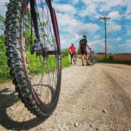
From today's Road Ride Digging this pic courtesy of @richiefthenos 🚲💪👍✌
0 notes
Photo

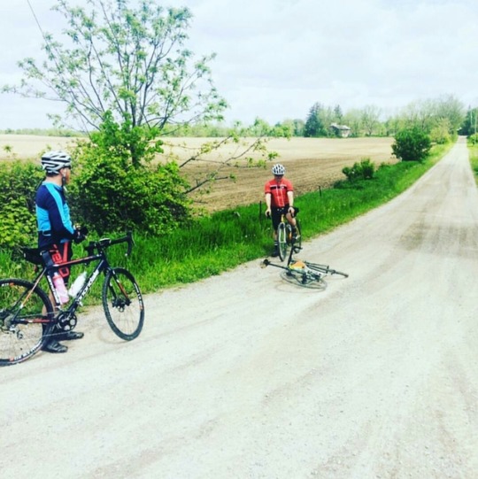
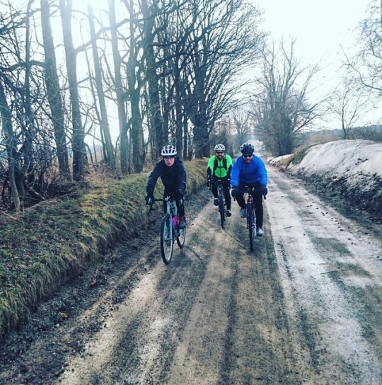
Great to get out today with @richiefthenos and @reidcoolsaet and Jeremy. Lots of hard climbs n sweating buckets!!
0 notes