
Riku | 30 | he/him | This blog is something with which to spare my friends from overexposure to a fandom they did not sign up for.
Don't wanna be here? Send us removal request.
Statistics
We looked inside some of the posts by dragonageoutlet and here's what we found interesting.
Average Info
Notes Per Post
47K
Likes Per Post
26K
Reblog Per Post
21K
Reply Per Post
5
Time Between Posts
24 days
Number of Posts By Type
Photo
8
Text
8
Note
1
Last Seen Tumblr Blogs


Fun Fact
Tumblr.com is the 103rd most visited website in the world.
Photo


Keezy (x)
3 days till Dragon Age Inquisition and nothing else matters. I’m going to explode (so I drew everyone and their emotional problems haha…)
Message me if you want these in separate posts~
23K notes
·
View notes
Text
Something in da4 that would be REALLY fuckin funny to me is if Varric is just around to explain plot holes left from da2. If the plot demands that Fenris or Anders or both be alive when the player has a file where one/both dies, they should just show up and someone turns to Varric like "didn't you write that they died" and Varric should just shrug
1K notes
·
View notes
Text

They shall cry out to their false gods,
And find silence.
—Andraste 7:19
-
in which my bastard inquisitor runs the biggest scam of all time and ascends to prophethood
641 notes
·
View notes
Photo

Ghilan'nain: Sovereign of Halla, Architect of Sea-Scented Horrors
247 notes
·
View notes
Photo
Andaran atish’an
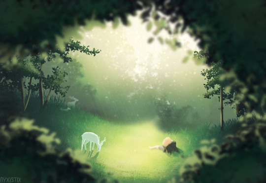
Even inquisitors have to rest sometime !
166 notes
·
View notes
Photo

I’ve racked up 35+ hours in this game since getting it 3 days ago and most of it was spent on trying to befriend Fenris
7K notes
·
View notes
Photo

Guess who is back on her Dragon Age bullshit. Its me!
I haven’t actually played Inquisition in..2 years? Its been a while. But I’m back on it with my new lovely Lavellan.
37 notes
·
View notes
Note
I look in wonder at your skills with Thedas' map. I have a problem I wish I had an answer to: How does Redcliffe village work? We get different maps for it in DAO and in DAI (supposed eastern part) and they don't seem to fit together. I can also not make heads or tails of Redcliff's supposed location on the world map (like with position of rivers/lake) in relation to the mini map in, say DAI. Nothing seems to add up. Could you help me make sense of this? Maybe maps need some turning or sth.?
*blush* Thank you so much for your kind words! It is a labor of love…that occasionally causes me to want to tear my hair out. ;) Redcliffe is one of those places that makes not only my scalp to itch, but my eye twitch. (So at least we are in good company.)
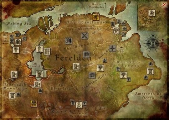
Nothing about the geographical lore of Redcliffe makes any sense. For example, the codex entry used both in Origins and Inquisition is full of nonsensical statements. For example:
“King Calenhad Theirin once famously declared, “The fate of Redcliffe is the fate of all Ferelden.” Certainly, the castle is the first and last defense for the sole land route into Ferelden, and the country has never fallen to any force that did not first capture Redcliffe.”
Um…what? Redcliffe is on the sole land route into Ferelden? Redcliffe is even near the sole land route into Ferelden. It may be closer to Orzammar and Gherlen’s Pass than West Hill or Highever, but you could definitely reach Denerim without having to travel close to Redcliffe.
Now, you could definitely argue that it would be really, really bad idea to leave Redcliffe untouched if you planned to occupy Ferelden. By the time an invader reached Denerim, Redcliffe could muster an army and use the southern arm of the Imperial Highway to aid Denerim or attack from behind. So if this was the only incongruous information, I could deal with it, but then there are these nuggets:
“The castle, which despite being three times captured is popularly described as “unassailable,” also guards one of the largest and most prosperous towns in Ferelden. Redcliffe village is well situated near the mountain pass to Orzammar and the Orlesian border, and so serves as a center of foreign trade. For these reasons, Redcliffe is accounted an arling despite the smallness of the domain.”
Again, huh? Don’t you mean the reverse? Redcliffe is a village of about 200 people, but the arling itself is quite large. Honnleath is part of the Arling of Redcliffe, and presumably parts of the Hinterlands are also included under its protection. So it isn’t exactly small.
And whatever the scale of the map you use to calculate how far it is from Redcliffe to Orzammar, it is strange to say that Redcliffe is “near” the pass that leads to Orzammar and Orlais beyond. It is at least 150-200 miles to travel between Orzammar and Redcliffe. There are several other Ferelden towns and arlings (Kinloch Hold, Wutherford, West Hill Bannorn, Waking Sea Bannorn) that should be better situated to profit from international trade than Redcliffe. But it gets better:
“The inhabitants of Redcliffe village are primarily fishermen or merchants who ship dwarven goods through the pass from Orlais to Denerim. When the entire village smells of smoked fish on certain late autumn mornings, the merchants in their finery do their utmost to pretend otherwise.”
–From In Pursuit of Knowledge: The Travels of A Chantry Scholar, by Brother Genitivi.
Sigh. Why would you take dwarven goods all the way south to Redcliffe if you plan to ship them to Denerim? That tacks on hundreds of miles to your journey! Just take the North Road!
None of that makes any sense…unless you look at where Redcliffe was in The Stolen Throne.

If Redcliffe were located where it was placed on this map, then the codex entry about it would make complete sense. It would be a much smaller land area, but the position of the town would make it a far more likely trade center and “first and last line of defense” for Ferelden.
There are even signs that this location almost made it into later maps.

In spite of the fact that moving Redcliffe messes with the lore about the village, it appears on the southern shore of Lake Calenhad on every other map that Bioware has published.
So why did the developers move it? Most likely it was game mechanics, or rather, button mechanics. If Redcliffe had remained where it started out, it would have made the button placement on the Origins map rather awkward. It is so close to Haven that players might have confused the two.
(There is a similar problem with where the Temple of Sacred Ashes should be. It should be very close to the edge of the game play map in the mountains to the west of the town, but in game it appears an equivalent of 35-65 miles south of Haven so it won’t be so close to the edge and it won’t obscure any writing.)
And most casual game players wouldn’t think there was anything strange about Redcliffe being so far from Orlais and Orzammar. In fact I was really glad it was so close to Lothering the first time I played Origins. Only when you are really examining the geography of Ferelden does its placement become questionable. Am I 100% sure this is the reason? Not at all, but the map sure is more balanced with Redcliffe at the bottom of the lake and easier to read, all of which is desirable in game play.
And then there’s the problem of DAI’s map. Sigh. So….I replayed a large part of the Hinterlands and did a bunch of math for this post. And I now have a bit of a problem with my own map.
I am pretty good with spacial relationships and so I used a lot of landmarks and large scale measurements to place various locations on the map I shared. That works well when adding towns, temples, landmarks, etc from the various published maps, but it doesn’t work so well for the highly detailed area maps in Inquisition.

I confess that I should have done a bit more math when I started to add Inquisition zones to my map. If I had I would realized that this small neon green dot you see above is the equivalent of about 5 square miles, depending on which map scale you use. I went with the smaller 1” = 50 miles scale. That dot is 1/16” x 1/16”. That means there is more than enough space for the whole Hinterlands map, which is about 2-3 square miles, to fit into that tiny green square. Wow.
(BTW, I went out to the interwebs to see if others people had come up with a similar area number, and found an estimate that all of the areas in the game put together (minus DLC) is about 45 square miles. They probably went with the larger 1” = 70 miles. That would make Thedas about the size of Western Europe, I think.)
So the reason it is difficult to figure out the DAI landmarks on the Thedas map is that the map is far too small for such minute detail. I’m going to have to ponder what to do now that I know the true scale we are dealing with and update my map accordingly.
Thanks for the ask! It made me do math, and we’ll get a better map at the end as a result. :)
-MM
788 notes
·
View notes
Text

You were always so patient with me.
Maevaris Tilani and Thorold Tethras sharing a quiet moment together, a commission for @thatindyamy <3
Very happy to draw this piece for you, both because of your birthday and pride month!
577 notes
·
View notes
Photo
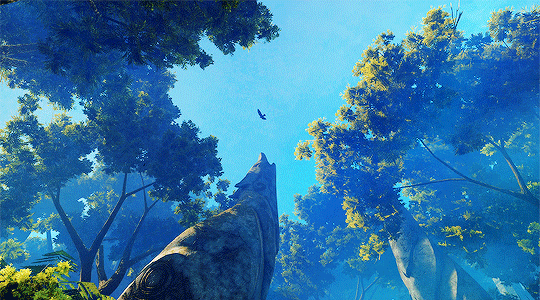

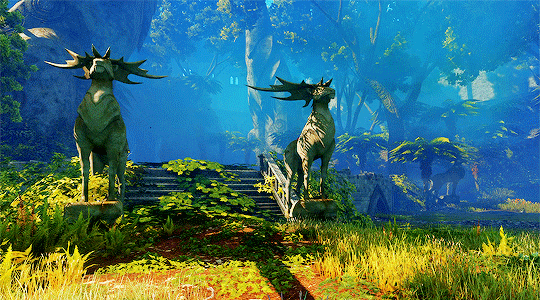


DRAGON AGE: INQUISITION | REPLAY ➤ The Arbor Wilds
4K notes
·
View notes
Text

’… like dogs, shianni.’
commission for @frecklef0x of their warden aidah tabris, giving kendells what he deserved.
1K notes
·
View notes

Text

Found this in my files. Don’t remember why I made it, but it needs to be shared with the world.
578 notes
·
View notes
Text

One week before the anniversary of Stonewall, we celebrate the Trans members of our community. Trans Rights are human rights.
27 notes
·
View notes

Photo

WHY DID NO ONE HECCING TELL ME THIS WAS A THING?! IT CAUGHT ME RIGHT OFF-GUARD AND I MAY BE SCARRED FOR LIFE.
OH YEAH, DEEP ROADS AFTER THIS IS ALSO FUN WITH SHRIEKS AT EVERY TURN. IMAGINE GOING THROUGH SO MANY FLASHBACKS YOU’RE BORDERLINE PSYCHOTIC BEFORE THE BROODMOTHER
21 notes
·
View notes
