
Statistics
We looked inside some of the posts by dsandrvk and here's what we found interesting.
Average Info
Notes Per Post
1
Likes Per Post
1
Reblog Per Post
0
Reply Per Post
0
Time Between Posts
1 day
Number of Posts By Type
Text
17
Last Seen Tumblr Blogs


Fun Fact
Tumblr was acquired by Yahoo for $1.1B in 2013.
Text
Monday, June 2 - Stirling to Glasgow Airport

View over to Abbey Craig and Wallace Monument with highlands behind

Robert the Bruce
James V on the corner of his palace

King's Knot and the King's Park below the castle

Mary og Guise's throne room

Some of the replica Stirling Heads on the ceiling in the King's throne room

Replica of Head of James V

A burst of color on a gloomy day

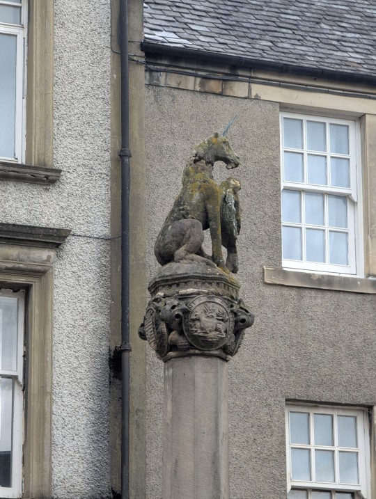
The western face of Stirling Castle

It was a gloomy day, but no rain was in the forecast, so we packed up our rain gear along with all our other stuff except our small day packs, and left it at the hotel to pick up later. Buying tickets to Stirling Castle on-line saves money, so we did that just before we headed out, as we had to specify a half-hour time window for entrance, and we dawdled just enough on the walk up through town to get there at just the right time.
The castle is a Scottish Heritage property, and they have worked hard on restoration and interpretation, and we spent over four hours there, wandering through exhibits and outdoor spaces. The views from the ramparts were wonderful - no wonder it is said that who controls Stirling Castle controls Scotland. It is easy to see how this is the gateway to the highlands, too, as the hills are just to the north, while the flatter plains of the various battlefields stretch to the south and east. Indeed, the castle was always changing hands between the Scots and the English - in the 1300's control changed eight times in 50 years.
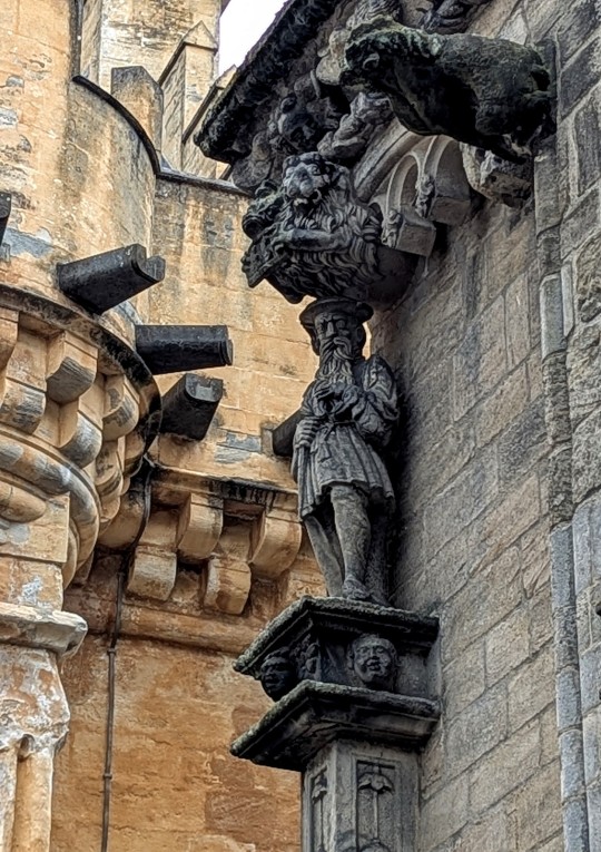
A large palace was built here in 1540 for James V of Scotland, and no expense was spared to show that Scotland was just as "civilized" as the rest of Europe. The exterior has lots of gargoyles and carved depictions of people and demons, as well as beautiful gardens, all within the older defensive perimeter. His presentation room has a ceiling with 56 colorfully painted carved heads depicting ancestors, mythical figures, as well as James and his wife, Mary of Guise (Marie de Guise in her native France). The originals have been removed and some are in a gallery on site, and some are in museums, but they have been faithfully recreated by master carvers, and installed on the ceiling in the palace.
In addition, a series of tapestries, based on The Hunt for the Unicorn, have been recreated by master weavers over a 13 year period. These are now in Mary's presentation room, and are probably similar to ones owned by James V, which were originally created in the Netherlands. There is a wonderful exhibit elsewhere on the castle grounds explaining how the new tapestries were made by hand, and highlighting the artists who worked on them, as well as explaining the symbolism in each one of the seven. The unicorn is a symbol of Scotland, but also is considered to be a Christ figure.
James V died in 1542 after a botched attempt at invading England, so didn't get to spend much time in his palace. His widow, Mary, ruled as regent for her infant daughter, now known as Mary, Queen of Scots, Mary, Queen of Scots' son, James VI eventually became James I of England, finally uniting the two kingdoms.
Other parts of the castle included an older section occupied by James VI, now the Argyll and Sutherland Highlanders Regimental Museum, as well as a chapel built for Mary of Guise, and a great hall built by James IV. It is always a little disturbing to me that no expense was spared during festivities in these spaces, while the peasants were often barely existing, but it is fascinating to see how they lived. James VI wheeled in a 5 meter long fully rigged replica ship here with 36 brass guns, filled with fish made from sugar as a celebration of his son Henry's baptism. It's good to be the king.
Eventually we made our way back through the gates and down the "back walk" into town, passing the old hospital, old jail, and other places in this historic town. We stopped for some fish and chips before retrieving our luggage, and continuing on to Glasgow by train, where we took the airport bus out to our airport hotel.
The plan is to get up tomorrow around 3 AM to be able to check in and drop bags for our 6 AM flight, since there aren't any kiosks to make it go faster. Then three flights to Grand Junction and a night there with friends before heading back home. It's been a long trip, but we've seen so many marvelous things and met a lot of wonderful people. It will take time to process everything, as well as sort out pictures and memories. Traveling is always a thrill, but I look forward to my garden.
0 notes
Text
Sunday, June 1 - Stirling, Scotland

The old bridge built in the 15th century

Pedestrian bridge across the railway

Racing shells on the river

The Abbey bell tower dating from around 1300

The Wallace Monument built in 1869
The meanders of the Forth

Wallace on the corner of his monument

Stirling Castle above the Kings Knot earthworks

Some of the carvings on the trail to the Wallace Monument

The Clock Tower
It was raining as we finished up our breakfast so we started out in rain jackets and rain pants, but the "all day rain" predicted never materialized, and pretty soon we were removing the rain pants and a couple of extra layers. We had planned a circular hike up to Abbey Craig (one of the glacial hills that tower over the river valley), and were surprised to find a lovely historic town across the river to the east called Cambuskenneth (field of Kenneth) and a ruined abbey (yes, another one) on our route. There has been a lot of history in this relatively small area, and we are just starting to realize how central this place was for the fight for Scottish independence.
The first mention of Stirling Castle was in 1110, although King Kenneth defeated the Picts here in 834, establishing the royal lineage in Scotland. This is 200 years before Macbeth (yes, he was real). By 1140, the Abbey here was founded by King David I, and Scotland was recognized as an independent country 50 years later. That didn't last, however, since in 1296, Edward I of England invaded Scotland, leading to the resistance led by William Wallace. This led to another decisive battle on the plain below the castle - the Battle of Stirling Bridge, where an outnumbered Scottish force defeated the larger English army. Wallace continued his resistance until 1305 when he was captured (and "judicially murdered", as one account put it) and he is still greatly revered here.
The Wallace Monument was built in 1869 on Abbey Craig, and is part of the same trust that owns the Abbey grounds a mile or so south. We had seen a route on a map that took us up to the top of the Craig by a different path than the standard trail, and had the wooded slope to ourselves until we neared the top. By now the rain had stopped, but the wind had come up, especially along the edge. As a result, we opted not to go up in the monument, as the viewing area from the tower is open, and we were more interested in a presentation by a living history gentleman talking about the history of Wallace's time. From the top of the hill here we could see far to the south a couple of miles to where Robert the Bruce fought and won another battle against the English, this time at Bannockburn in 1314.
Just to the west of Bannockburn there is another stream called Sauchie Burn, and this was the site of still another battle, this time when the Duke of Rothesay (where we were several weeks ago) defeated his father, James III to become James IV of Scotland. James III and his queen, Margaret of Denmark, are buried at the Abbey we had just visited. So much history in a two mile radius!
The trail down from the monument has lots of wood carvings from different eras and artists, and eventually led down to a park, from where we walked to the "old bridge" which is just downstream from where Stirling Bridge once stood. Once again, there were interpretive signs about Wallace. The old bridge is now pedestrian only, and dates back to the 1400's.
We came into Stirling from the north, passing this clock tower, and returned to the hotel for a little rest before heading out on an evening adventure. We decided to walk along the base of the craig on which Stirling Castle sits and explore a different corner of Stirling. In this area there are lots of really nice residential properties and the cars that go with them (Ferraris, Porsches, etc.), although they all have to park in what we would consider the front yard, since street parking was metered or non-existent. We also noticed that several of the paths at the base of the cliff were closed - we realized it was because large boulders had come down during the recent rains.
We arrived at an area of extensive earthworks which looked like they could have been built for defensive purposes, but were actually built in 1627 in the royal hunting park to show off the wealth and prestige of Charles I, in anticipation of his "homecoming". The remainder of what was once the King's Park is now a golf course.
We returned to our pub for another evening, and had another good conversation with some young people who run the place. They are planning to get married in a couple of years and want to honeymoon in the US, so we gave them some ideas for their selected destinations. Since it is a Sunday evening, it wasn't crowded and we left before they started "pub quiz night", as we have walked about 11 miles today and need to get some sleep.
Tomorrow we plan to go up to Stirling Castle, which is the "must-see" here, and it shouldn't be as crowded on a Monday. We have "any time" tickets to Glasgow tomorrow, so will try to make the most of our time here before heading to our airport hotel.
0 notes
Text
Sunday, May 31 - Edinburgh to Stirling
Virgin Hotel Edinburgh entrance - fairly low-key

Stirling train station

Market Square in the Old Town
Close-up of "The Puggy"
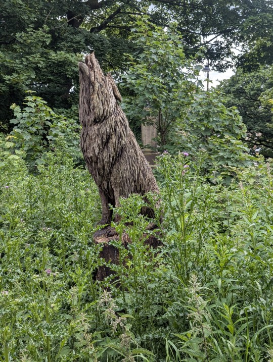
The wolf is the symbol of Stirling

Stirling Castle above the graveyard
Our hotel

Our friendly pub
After our long travel day and fun night at the pub, it was lovely to sleep in and not worry about any tours, lectures, hikes - nothing except breakfast. Obviously many of our fellow passengers had a similar non-schedule or later flights as we met many one last time again for breakfast.
Trains to Stirling run about every half hour on Saturday, so we were able to board one as soon as we got to the station, and were in Stirling by noon. Edinburgh was quite crowded and the Royal Mile was torn up for repaving, so we were glad to escape to the relative calm of a smaller city.
Stirling is the site of quite a bit of Scottish history, and is an extremely walkable town, with the Forth River meandering in the lowlands and the castle above on a tall hill left behind by the glaciers. The old town is clustered below the castle with several streets leading steeply uphill. Much of this area is residential with the main business streets below on flatter ground near the train station. Our hotel dates to 1786, but our room was quite modern and comfortable.
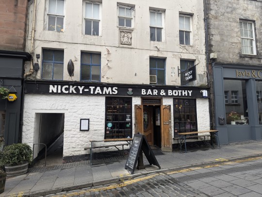
We took a stroll up the "Back Walk", which is a pedestrian only street that steeply ramps up on the southwest side of the escarpment, and eventually to the base of the castle. We wandered off of it to see the old town and took a scenic way back down for some fish and chips, and then went in search of a suitable pub. Stirling has a lot of cafes and restaurants, almost all with bars, but most lacked atmosphere until we happened upon Nicky Tam's, which was moderately crowded and looked promising. We managed to get a couple of seats next to some locals, and before long we were involved in conversations about neolithic and Iron Age sites in the British Isles and elsewhere - I don't think we've ever met anyone before who had been to the dolmens in Antequera, Spain, either. We asked them about the plethora of barber shops in town (I counted at least 15 in the 10 or so block area of downtown, and that doesn't include hair salons, which were even more plentiful). This in a city of about 50,000 people, spread out quite a ways from the main shopping area. It seems that COVID closures hit this area hard, but people still needed haircuts and the businesses also have fairly low overhead. George (our new friend), also speculated that some were fronts for other activities (wink, wink).
The Stirling area is home to a lot of significant Scottish history, including battles won by William Wallace (think Braveheart), and Robert the Bruce. It is in a strategic location between the lowlands and highlands, with a meandering river to cross, and the high ground of the Castle. I'll go into more detail on all of that tomorrow.
We are looking forward to doing a walk tomorrow out towards another escarpment that has the Wallace Monument at the top. The forecast is for rain, but we will gear up and explore. We like what we've seen of this small city so far, and are glad we opted to stay here rather than in Edinburgh or Glasgow.
0 notes
Text
Sunday, May 31 - Edinburgh to Stirling


Virgin Hotel Edinburgh entrance - fairly low-key

Stirling train station

Market Square in the Old Town

Close-up of "The Puggy"

The wolf is the symbol of Stirling

Stirling Castle above the graveyard

Our hotel


Our friendly pub
After our long travel day and fun night at the pub, it was lovely to sleep in and not worry about any tours, lectures, hikes - nothing except breakfast. Obviously many of our fellow passengers had a similar non-schedule or later flights as we met many one last time again for breakfast.
Trains to Stirling run about every half hour on Saturday, so we were able to board one as soon as we got to the station, and were in Stirling by noon. Edinburgh was quite crowded and the Royal Mile was torn up for repaving, so we were glad to escape to the relative calm of a smaller city.
Stirling is the site of quite a bit of Scottish history, and is an extremely walkable town, with the Forth River meandering in the lowlands and the castle above on a tall hill left behind by the glaciers. The old town is clustered below the castle with several streets leading steeply uphill. Much of this area is residential with the main business streets below on flatter ground near the train station. Our hotel dates to 1786, but our room was quite modern and comfortable.
We took a stroll up the "Back Walk", which is a pedestrian only street that steeply ramps up on the southwest side of the escarpment, and eventually to the base of the castle. We wandered off of it to see the old town and took a scenic way back down for some fish and chips, and then went in search of a suitable pub. Stirling has a lot of cafes and restaurants, almost all with bars, but most lacked atmosphere until we happened upon Nicky Tam's, which was moderately crowded and looked promising. We managed to get a couple of seats next to some locals, and before long we were involved in conversations about neolithic and Iron Age sites in the British Isles and elsewhere - I don't think we've ever met anyone before who had been to the dolmens in Antequera, Spain, either. We asked them about the plethora of barber shops in town (I counted at least 15 in the 10 or so block area of downtown, and that doesn't include hair salons, which were even more plentiful). This in a city of about 50,000 people, spread out quite a ways from the main shopping area. It seems that COVID closures hit this area hard, but people still needed haircuts and the businesses also have fairly low overhead. George (our new friend), also speculated that some were fronts for other activities (wink, wink).
The Stirling area is home to a lot of significant Scottish history, including battles won by William Wallace (think Braveheart), and Robert the Bruce. It is in a strategic location between the lowlands and highlands, with a meandering river to cross, and the high ground of the Castle. I'll go into more detail on all of that tomorrow.
We are looking forward to doing a walk tomorrow out towards another escarpment that has the Wallace Monument at the top. The forecast is for rain, but we will gear up and explore. We like what we've seen of this small city so far, and are glad we opted to stay here rather than in Edinburgh or Glasgow.
0 notes
Text
Friday, May 30 - Longyearbyen to Edinburgh
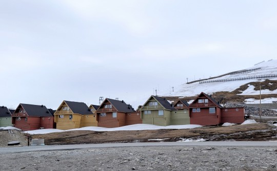
Colorful housing


The shopping mall

The "dinosaur" - a meeting place in Longyearbyen

At least we saw this bear


Dog team and wagon

The polar bear signs are everywhere

Our pub in Edinburgh
It was a long day with a bit of culture shock. We were in the first group to leave the ship, and it worked quite well with the Zodiacs, except for a few people who brought small roller bags, which were hard to get on and off. After our bus was filled we had a short ride over to "downtown" Longyearbyen, which is about six blocks long and two blocks wide. Housing stretches from there in all directions. Our tour guide was from Mexico City, our other guide was from Ohio, and our bus driver was from Croatia (I think). Truly international. In fact, in the entire town we never met a Norwegian - this seems to be the kind of place that people tend to wind up in, for one reason or another.
There were several gift shops in town, and a surprising number of outdoor gear and clothing shops - not geared to the souvenir trade, rather to the folks wanting another Patagonia jacket or Marmot pants. There is also a fairly good size grocery store, and several bars and lots of coffee shops. They also have a fairly new museum which covers the history and natural history of the place, including lots of stuffed animals, including this polar bear. They are quite large and impressive.
After our museum visit and free time to explore and shop, we had lunch at the local Radisson hotel, which was lovely, except they really weren't ready for 100+ people to descend on them in the space of 15 minutes. The Radisson is actually reconverted housing from the Lillehammer Olympics when some event was held here. From there it was a short bus ride to the airport which was small but relatively efficient and low-key. The little cafe and store after security held the usual last minute stuffed animals and food gifts, but also a huge number of rubber spatulas painted with a polar bear. There didn't seem to be a run on them, from what I could tell.
After a long, uneventful flight, we discovered that the Edinburgh Airport has grown too much for its facilities. Four flights had landed within 9 minutes of each other, and immigration was epic, even with the new automatic kiosks. And there were only two bag carousels for the four flights. By the time we finally got bussed to our hotel, we were pretty much over lines, so we were pleasantly surprised that as we entered the Virgin Edinburgh Hotel lobby, they asked our name, gave us an envelope with our key, etc., and that was all we had to do to check in.
We made a brief stop in our room, which was on the 4th floor, but actually down in the elevator from the lobby, which was on 6. This part of Edinburgh is on a hill, so the hotel, which is In several older buildings sort of cascades down to open onto several levels. It is in the Grassmarket area, south and east of the castle, which is an area we know from our last trip here. As a result, we decided to seek out a friendly pub we had visited before - The White Hart - which is only a five minute walk. We had some cask ales, met several members of a Welsh rugby team, and sang along with the evening entertainment. It was a fun way to end a varied day, and we don't have to worry about getting up early tomorrow, since our train tickets are good anytime during the day, and we only have to get to Stirling, less than an hour away. Should be fun.
0 notes
Text
Thursday, May 29 - Svalbard

The most intact building (which is still in use)

Loading pier

Reindeer

Reindeer winter pelt

A leaky tea kettle

Remains of a small rail line, probably with a former snow shed structure

Flowers!

Loading pier with structure

Abstract of a partially snow-covered gully

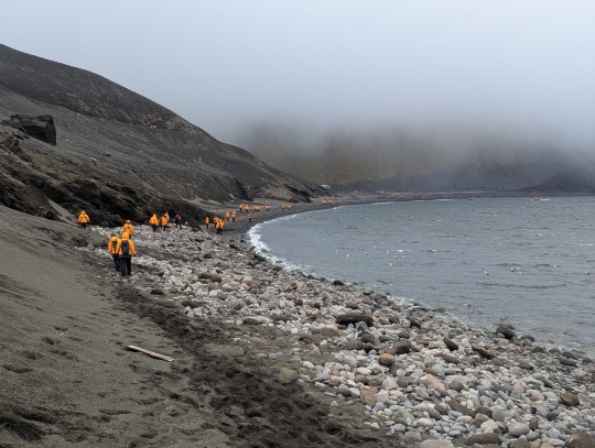
Today was our last full day in the semi-frozen North, and it was a beautiful one. We started the day with another landing and hike - this time to a former coal mining area a bit west of Longyearbyen, called Colesbutka. This had been one of the Russian operations here in Svalbard. Svalbard is under the sovereignty of Norway but the Svalbard treaty signed in 1920 stipulates that all signatory nations have a right to exploit the mineral resources, including Russia and China.It also stipulates that the archipelago stay demilitarized. Russia still operates one coal mine, but doesn't ship the coal anywhere as a way of maintaining a presence here.
The operations here closed in 1962, but the buildings are still in fairly good condition. The mine itself was several kilometers away, and the coal was processed here, and then loaded onto ships from one of the three piers. The railway between the mine and here is gone, but some of the ties still remain as well as the bottom parts of what were probably snow sheds. After we left and headed east, we could see with binoculars the cut of the railway along the cliffs, and also some more intact snow sheds, as well as where the rail line disappeared into a tunnel.
Walking around the site was interesting, as much of it was just left in place. There is one building that has been maintained and it was flying a Russian flag as well as a flag for the science institute here. I think it is supposed to be a museum, but it wasn't open. Strangely, we saw more birds here than on most of the other days in Svalbard, from Snow Buntings to several species of geese, Glaucous Gulls and Eiders. We also saw several reindeer carcasses - mostly completely eaten except for the pelt, and several more shed antlers. There are still a lot of metal wires and pipes and other hazards throughout the site, and one of the expedition staff posited that perhaps these individuals got tangled up in things. They died this last winter, since the fur was all white. We did see several live reindeer also hanging around.
We then spent the afternoon sailing up a couple of fjords to the north, although before leaving Colesbutka Russ and I managed to get in one last visit to the hot tub before we finished packing. Because of the nature of the port at Longyearbyen, we will be taking Zodiacs to the shore tomorrow, so need to send our carry-on packs ahead tonight with our other luggage, since we only want to take a smaller day pack on the Zodiac and also around Longyearbyen tomorrow.
Just before dinner we pulled into the bay by Longyearbyen and heard a sound we hadn't heard at any time on our trip - the anchor being deployed. We will be spending the night with a view of the town and a Viking cruise ship which is in port for just tomorrow (and the reason we will Zodiac in tomorrow, as they are docked).
It is hard to say goodbye to a lot of the folks we have met, and the staff we have become close to. There's always a Captain's farewell and a tribute to the staff, which is a good time for last minute exchanges of contact info, etc. We have met some wonderful people we hope to keep in touch with, and had dinner with our Tasmanian friends.
Tomorrow will be a long day, as we have a tour and free time in Longyearbyen, as well as lunch, and then our charter flight to Edinburgh and a night in a hotel there. We are lucky in that we are on the first of the two flights so should get to Edinburgh around 7 or so, and still have some time there in the evening. At least we can hope.
0 notes
Text
Wednesday, May 28 - Svalbard


Some lichen the reindeer haven't eaten yet


A long ride back from the glacier

Walruses


Crevasses

The sun comes out


Another small sailboat
Because we had only a short distance to go for our morning outing, we positioned in a beautiful spot all night (which of course was never really "night"), and then moved on in the morning. Usually the mornings have been overcast with the sun appearing later in the day, but today it was beautiful right from the start.
Once again we had a choice of hikes, and did the longest one, which was organized a little differently. Yesterday we merely followed our expedition person with the rifle, but got spread out and no one cared. Today's country was a little more cut up with lots of little moraine ridges and small valleys and as a result there were more bear guards, and we stuck together, only stopping a couple of times as a group. The terrain made it a bit more difficult to watch for bears, and this seemed a good strategy. Once again, we were treated to a nice sighting of several reindeer, who seemed pretty unconcerned about us, but no bears.
At this site there were also pieces of leftover wood from hunters. Svalbard has been used for hunting and mining for a long time, and while most of the coal mining has ended, hunting of some species is still allowed, including the Arctic fox and the Svalbard reindeer. This hunting is heavily regulated and limited to permanent residents of Svalbard, although non-residents can, with the proper paperwork and licensing, still hunt hares, some seals, ptarmigan and other other birds. Polar bear hunting has been illegal on Svalbard since 1973.
This area has been heavily used by reindeer and their hoofprints and scat are everywhere. In most other places, reindeer or caribou migrate during the winter to find more plants on which to forage. Here, of course, they can't migrate, so they eat as much as they can during the summer, which makes for robust scat. In the long winter they only have a few options, such as lichens, and their digestive systems come close to shutting down, and the result is tiny pellets, about the size of rabbit scat.
During lunch we traveled from our hiking location to a bay further north with a huge tidewater glacier. We had a Zodiac cruise over to it, but first went out to a narrow strip of land on the outside cusp of the bay where there were around 7-8 walruses just lolling around and mostly sleeping. The rules required that we stay a good deal away from them, so my real camera pictures are better than the one I've included with my phone.
Since they aren't the most dynamic animals when they are just sleeping, we moved on to the glacier after everyone got a chance to snap a picture. We were in the second group to go out in the Zodiacs and were able to get closer to the glacier because the wind had shifted and moved away ice that had been closer in. We had hoped for a little sun on the glacier, but our beautiful morning had become overcast, windier, and a bit colder. Our temperatures all day hovered around 32 degrees , as they have most days..
Finally, as we pulled away from the glacier and our ship headed south again, the sun did reappear and we had a beautiful evening again, although there was quite a bit of wind. As a result we decided not to eat outside for dinner and instead went up to the Club for a feast of sushi, sashimi and a dragon roll. We also, sadly, started to do a bit of organizing and packing as we have only one more day before we leave our ship. We have been so lucky with the weather and incredibly calm seas,
Tomorrow we have another landing - this time to an old coal mining site, which should give us a feel for how these operations were laid out, and what modifications lthey had to make to live and work in this extreme environment. In the afternoon we will cruise up a few additional fjords while most people will pack up. It's so hard to believe this part of our journey is almost over.
0 notes
Text
Tuesday, May 27 - Svalbard

Beautiful light during dinner

Caviar and Mimosas on the back deck

The mountains aren't that high, but they stretch on forever

A glacier at one end of our hike

A variety of rocks

A small sailboat comes into view

Our Tasmanian friends who also like to eat outside

Scene from our balcony at 11 PM

Same location at 1:15 AM
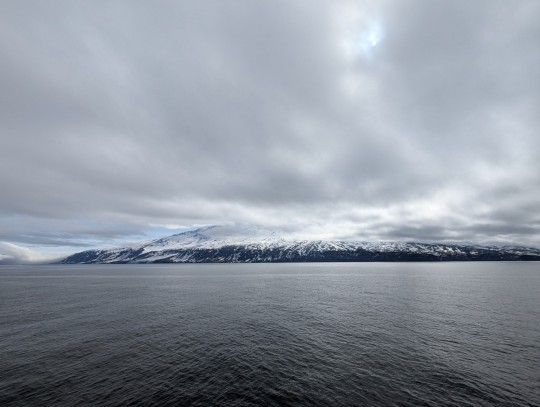
We finally came down south to Svalbard and got to set foot on the island of Spitsbergen. Overnight we headed down the west side of the archipelago and into the main channel towards the capital of Svalbard, Longyearbyen. We didn't need to go far in that direction to pick up our pilot, who will be with us for the next three days. We then headed back up north between the main island and a smaller island to the west to our stop for the afternoon.
Just sailing up the channel was amazing, as the snow-covered mountains seem to stretch on forever. They are not particularly high, all being below 5000', but they rise up directly from the water in many places and we passed quite a few glaciers, many of which still reached the sea. We had a little champagne and caviar party while we glided past.
After lunch we went ashore in smaller groups and were able to choose between a shorter hike, a stroll on the beach, or a longer walk up a moraine for views back over the bay and also a small glacier - you can probably figure out what option we chose. Because this is polar bear country, everyone on shore has to be accompanied by "bear guards", in our case several members of our expedition crew. They first scouted before any passengers were allowed on shore, established a "secure perimeter", and then led hikes out with a guide with a rifle in front. Polar bears may look cuddly, but of the three major types of bears, they are by far the most deadly. The adage, "if it's black, fight back, if it's brown, lie down (and play dead), and if it's white, say good night!" is not unfounded, and every year or so a local loses their life.
The snow had pretty much disappeared down by the beach and on the moraine itself, but there were patches of snow to wade through, and in some places it was slippery mud, but the rocks on the moraine were a fascinating mixture of black and white. I forgot to take pictures of the rocks until we were on our way back down and by then we had to hurry. The one picture I did take doesn't do it justice, as these weren't the best examples.
The views from the moraine hill were great, although it was still mostly overcast, so the glacier didn't "glow", but it was great to walk a bit outside after having been at sea for four days. We were hopeful for wildlife, and we did see a few far-off reindeer, still in their white coats, and an earlier group got a quick look at an Arctic fox. It is highly unlikely we will see a bear now that we are in Svalbard, since the moment we do, we have to back off a long way with our ship, or even a Zodiac because of new rules. We would probably have to watch it through the mast camera.
It was a beautiful evening to eat outside again, as the sun finally came out and totally transformed the landscape. The mountains really pop against the blue sky, and as you can see from the last photo, it continues to make the landscape look amazing, even in the dead of night.
Tomorrow we have a couple more stops planned - one with another good hike, and the afternoon with a Zodiac cruise tour to a tidewater glacier. Let's hope the weather continues to hold as it has - we have been so lucky!
0 notes
Text
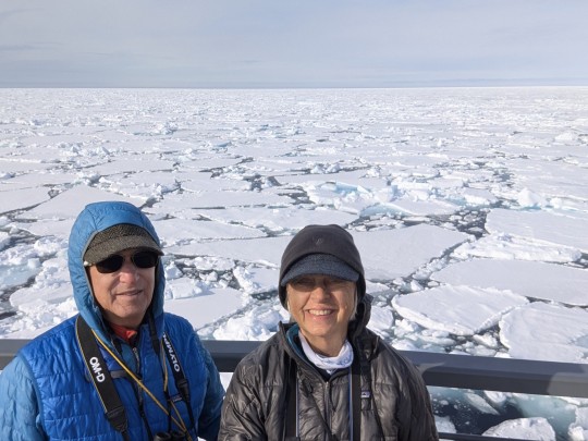
Monday, May 26 - North of Svalbard

Svalbard in the sunlit distance at 2 AM

Our path through the ice - red is 100% ice, blue is open water

Svalbard

We were less than 590 miles from the North Pole

Mast cam photo of seal

Max's drone shots of the ship

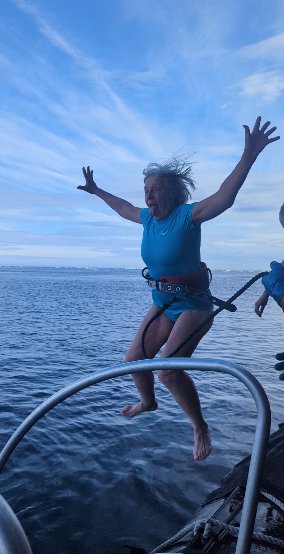
Polar plunge

Get to that ladder quickly!
We had another morning of cruising around the ice looking for wildlife and watching the ice go by. Last night we had sun all night long, at least on the mountains to the south in Svalbard. It's a little disconcerting to wake up at 2 AM and think one must have overslept since it's like late morning , but we're used to it by now.
We did find one seal on an ice floe, but it was quite far away, and the shot I've included is actually from our "mast cam", which is equivalent to a 1000mm lens and is handy when even binoculars don't really cut it.
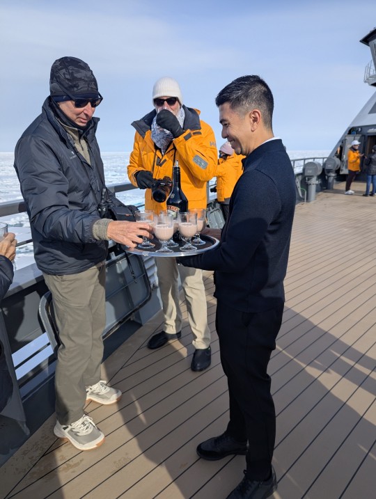
We left the heavier ice late in the morning and found a great area to do our "polar plunge". This is a tradition with a lot of cruise lines and Seabourn has a great set-up for it with a party atmosphere, shots or glug before and after, a nice rack for hanging the robes, etc., and lots of towels afterwards. Since we did this in Antarctica we knew what to expect and wore t-shirts so that when they put a cold wet harness around our waists it isn't quite as bad. Then there's a bit of a wait at the bottom of the stairs, the scramble across the Zodiac to the seaside tube, getting clipped in and then the launch. The water was around 29.5 F (sea water) and the air was around 28.5, so it was pointed out to us that it was warmer in the water - not that I spent any extra time in it. But with a dry towel, robe and a second shot of Patron, all was right with the world. We joined quite a few others in a hot tub, too, which was lovely. In the end only 64 passengers decided to take the plunge, which is a little more than a quarter of those on board. In Antarctica we had more than half, but that day was sunny with no wind. As our expedition leader pointed out, it's a few minutes of discomfort for a lifetime of bragging rights, and we are now officially "bi-polar".
All in all, it was a fairly quiet day, but fun, and we are looking forward to the next three days when we will visit the islands of Svalbard and get to explore on land a bit, even with the new restrictions Norway has put in place. We hope to see some other wildlife there, too.
0 notes
Text
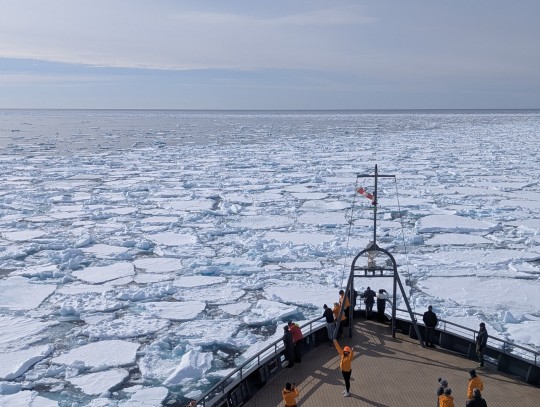
Sunday, May 25 - in the ice north of Svalbard

Hot chocolate and Bailey's

Up close and personal with the ice

Greeted by our bar staff with champagne

Our cruise director Olivia - only polar bear we've seen so far

Zodiacs trapped in the ice
High and dry on a floe

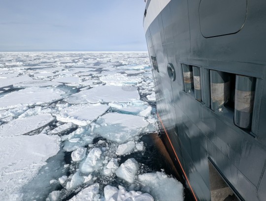
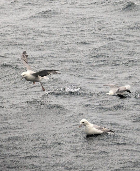
We had a lovely sunny day in the ice well north of Svalbard. We actually got as far north as 80.5 degrees, and there was still quite a bit of open water. We spent the morning finding a nice bunch of sea ice and powering our way through, looking for wildlife. There were birds, but nothing larger, but it was great out on the bow to watch the ice move and break and tumble as we plowed through. The temperature was right around freezing, but with the sun and almost no wind, it was quite comfortable, even without the heavy orange parkas. Still, it was nice when one of the bar staff showed up with hot chocolate and Bailey's to warm us up
They also opened the mooring doors, which are small wing platforms down off of the room with the mooring lines and anchor chains, so that we could get closer to the ice along the sides of the ship. It was a different view, although our favorite location is usually on the front of the bow, looking down at the bulb. Our ship isn't a true icebreaker, as they ride up on the ice and then use their weight to "break" down through the ice. Rather, we have a Class 6 hull which is ice hardened, and we sort of nudge the sea ice to one side or another.
After lunch and trivia (we finally won again!), we had an opportunity to get out in the Zodiacs along an edge of the sea ice. We had hoped for wildlife, but had to settle instead for the bar staff serving us some champagne from an ice floe. The ship has to work with what's available, and there just hasn't been much in the way of wildlife, other than a couple of seals. But everyone remains hopeful.
We were in the first half of people going out in the Zodiacs, and right after we got back on the ship they announced that the needed to reposition the ship before the next groups went out, as the sea ice was closing in. It happened quite quickly, and two Zodiacs with a special photography program actually got trapped in the ice for a while and two other Zodiacs with passengers couldn't get back on the ship because of the ice, although they and the bar staff and several other Zodiacs were able to stay out in open water.
One of the trapped boats got out fairly quickly, but the other got pushed up onto a floe, and it took at least a half-hour with the Venture using bow-thrusters to break up and move the ice around the Zodiac and eventually make a big enough wave to float them back into the water. Then the Venture made a parh through the ice that the two Zodiacs were able to follow until we got back out into open water, and all the passengers and crew could board, and the Zodiacs could be retrieved. The original plan has everything finishing by around 5:30, but the operation wasn't over until after 8 PM. Of course, being so far north, 8 seems like about 3 in the afternoon with the sun angle. We will definitely have midnight sun tonight, as this is the first night this far north without cloud cover.
We are planning to overnight out in another patch of ice, and then continue to wander amidst the ice looking for wildlife, before heading to Svalbard on Tuesday. Because of the stringent Norwegian regulations, we actually have a better chance of getting within camera range of wildlife out here, although we hope to see lots of glaciers, etc. on the islands.
0 notes
Text
Saturday, May 24 - At sea

Strong winds on the bow

This didn't happen to us on Jan Mayen

The azipods on our ship

We have new stabilizers, too

Orcas! (Pictures by our photographer, Max - mine are on my real camera


We're heading for the red (real sea ice

Yup, that's snow
Just as we were turning over this morning around seven for just another ten minutes of sleep, our in-room intercom sprang to life with an announcement (we can mute it, but then we'd miss stuff). There was a pod of Orcas way in front on the port side, so the ship slowed down, we quickly threw on some clothes and were greeted by at least seven animals, including a juvenile. They were in the distance to start, but eventually came close to the ship, and we all took lots of photos. I've included a couple of Max's photos (he's our expedition photographer - and has been for all three of our expeditions with Seabourn) as he shares many of his shots with us. I have some fairly good ones on my camera, but it's cumbersome to move them to the phone.
After we parted ways with the Orcas, we sped up again. Originally the plan has been to do two days of ice sheet exploration today and tomorrow before a sea day and then our time in Svalbard. But looking at charts and satellite photos, it seems the best chance to get to the pack ice without a lot of partial ice in the way is to go way north, above Svalbard, and then do our two ice days. So we really hit the accelerator and made sure we were in clear water (there had been a few icy bits floating around the Orcas this morning).
I've included a few pics of what our propulsion system and stabilizers look like. The azipods spin 360 degrees, which allows us to pivot in place, especially when combined with the bow thrusters, and today they were running at 161 rpm, which has given us just over 16 knots. The stabilizers are shaped like airplane wings and keep the vessel from rolling in higher seas, reducing the roll by up to 70%, They are also somewhat persnickety and this is the third set our ship has had in about three years, as there seemed to be a design flaw in the earlier models.
The picture with red is somewhat hard to decipher, but it shows the pack ice in red, lesser amounts of ice in the yellow and green, and open water in blue. Svalbard is in grey, and Greenland is out of the picture to the left. The west side of Svalbard is ice free due to the Gulf Stream, but the east side is still locked in ice. Our ship is over to the left of the picture - this was early this afternoon.
We were at a musical thing up in the Club this evening, and suddenly someone noticed it was snowing! It eased off a bit, but has returned now that it's after 11 PM (there is no dark here). We are currently at over 79 degrees latitude, and will be above 80 before morning, so we shouldn't be surprised about the weather, although it is just above freezing outside. We went from around 65 degrees in Iceland to 32 in Jan Mayen, but the seas are keeping us from getting much colder.
We are hoping to wake up to ice tomorrow, and all the possibilities that holds, whether it's walking on the ice, taking Zodiacs through the bergy bits, or hopefully seeing some wildlife and birds. Time will tell.
0 notes
Text
Friday, May 23. - Jan Mayen

The volcano on a clear day

Our landing spot in red


Whale bones
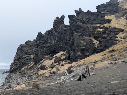
WWII lookout hut that was destroyed last year by weather
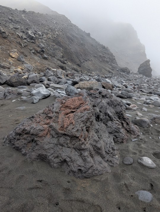
All kinds of volcanic rocks
Fulmars near the beach
Clouds coming down on the "beach"
Our view of the volcano

One of two glaciers we saw
We have managed to have a landing on another remote island - this one over 70 degrees north. It was 32 degrees outside with a very strong wind, but we dressed for it, and had a bumpy, but mostly dry Zodiac ride onto a black sand beach - in fact the entire island that doesn't have various rocks or snow is covered with black sand, sprinkled with olivine crystals.
Beerenberg, the volcano on Jan Mayen, is close to 7500 feet high, and is the furthest north volcano in the world. It is also the only volcano in Norway. We had hoped for a view of it, as pictures we have seen were spectacular, but the clouds were down even on the lower parts of the island while we were there - a not unusual condition. The clouds lifted a bit after we landed, and we had a few brief moments of partial sun, but by the time we left, we couldn't even see our ship or the ends of the beach. Occasionally the wind would gust strongly enough to almost blow me over, and the gritty sand was a bit painful on the face, but it was exhilarating to walk around a place few folks get to visit, and with such recent volcanic action (the last eruption was 1984, and she's definitely not done).
By the time we got back on board, the wind had really picked up, especially since we sailed along the north coast parallel to the island before heading more due north, and we seemed to pick up a downdraft off the volcano. As we passed by the volcano the clouds lifted enough to see the base and several lovely glaciers, but it was quite cold and windy to stand for long on the outside decks. After a cool and breezy outdoor breakfast the staff had decided not to set the tables outside, so al fresco dining is over for a while, but it was lovely while it lasted.
The afternoon was given over to trivia, lectures, and other pursuits, as the low clouds prevented a lot of wildlife viewing until later in the day, when we finally saw the horizon again.
Our next few days were vague on the official schedule, as they had planned for two days of exploring the Greenland ice sheet, but needed to evaluate when and where would be best. Because the ice is rapidly disappearing, our best bet is to head further north quickly and have another sea day before getting to the "good stuff" for a couple of days, and then on to Svalbard.
0 notes
Text
Thursday, May 22 - Sea Day
Normally a sea day is a chance to look for birds, whales, dolphins, etc., but today was fogged in almost completely all day. As a result, it was a good opportunity to attend some lectures, catch up on email and/or take a nap. We have also left the warmth of Iceland (a phrase not often uttered), and are now in the cold of the Arctic Ocean. We still sat outside with friends for dinner, but it might be the last time.
Tomorrow we are hoping to land on Jan Mayen, a small and very volcanic island over 400 miles north northeast of Akureyri. The island has a small weather station, and also a small Norwegian military presence, as it is part of Norway, although extremely remote from the mainland. Needless to say, it is visited very seldom.
0 notes
Text
Wednesday, May 21 - Akureyri, Iceland and the Lake Myvatn area
Godafoss

The stoplights in Akureyri are all hearts

Arriving at Godafoss in the fog

Below Godafoss as we were leaving

Lava formation at Dimmuborgir

Pseudo craters and Lake Myvatn

Icelandic horses

Part of the geothermal plant in a "Martian landscape"

Leaving our fjord with little snow remaining

10:30 at night and it's just beginning to be sunset time
Our beautiful evening approach up the long fjord to Akureyri last night turned to fog by morning, and it was challenging to even see that there was a small city outside our window. Akureyri is the largest city outside of Reykjavik and is home to over 40,000 people. It is also the main place for people on the north side of the Island to get supplies and services, and boasts a major hospital and a large library. Access to the west is on roads winding along the coast (including to Siglufjordur, where we were yesterday), but to the east there used to be only a mountain pass, which although only at about 1000 feet elevation, can be impassible in the winter. As a result, a two-lane tunnel was completed in 2018 that shortened the distance by 16 kilometers. It took longer than planned to be constructed, partially because they drilled into an underground hot water river, which added to the engineering. In typical Icelandic fashion, the locals voted on the use for the hot water that they were able to divert, and ended up with a local geothermal spa nearby. Also because of geothermal conditions, parts of the tunnel rise to temperatures of almost 80 degrees, and the locals have used lay-bys in the tunnel for hot yoga. The tunnel is currently Iceland's only toll road.
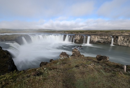
We were on the first group for an all-day tour to the Lake Myvatn area to the east of Akureyri. We had been to several of the scheduled stops eleven years ago, but this was a chance to get out into the country again and see what had changed. We started off in the fog, hoping it would lift so we could see a little of the scenery. Normally the tour goes over the pass to the east for spectacular views, and comes back through the tunnel for efficiency, but our guide and driver decided to reverse that, which worked out well. We had hoped to be clear of the fog by the time we passed through the nearly five mile long tunnel, but we still couldn't see much, until it started to lift a bit when we got to Godafoss.
Godafoss is one of the many spectacular waterfalls in Iceland, and also one of the best known. It translates to "waterfall of the gods", and one legend has it that when Christianity first arrived in around the year 1000, many locals were loath to give up their pagan statues. A local official named Porgeir made the compromise to embrace Christianity in public but allow others to worship the old gods in their homes. This man then threw his pagan statues in the river, where upon the gods rejected his sacrifice and split the river in two. The gods were smiling on us, however, as the fog lifted while we approached and the rest of the day was full of sun and blue skies, and very warm temperatures.
Because we had gone through the tunnel we were ahead of schedule, and able to spend plenty of time admiring the falls from several viewpoints. The river feeding the falls actually comes from the largest glacier/icecap in Iceland, on the south side of the island.
From here we headed on to Lake Myvatn, which translates to "midge lake", and well deserves that name. When we were here before, there were just a few parking areas from which to view the lake and no real interpretation. Now it is part of a National Park, and there is a lovely Visitor Center, and trails to overlook the "pseudo craters" that are only found here in Iceland (or on Mars). What hadn't changed were the midges/flies. We came prepared with headnets and there were several others on our bus similarly attired, but most of the others were just frantically brushing them away. At least they weren't yet biting at this time of year. They seem like a nuisance, but are actually vital to the ecology here, providing food for the birds, trout and salmon, and also fertilizing the area with their excrement and bodies.
This area is actually the rift between the two continental plates of North America and Eurasia, which are pulling apart, with new land being formed continually due to a hot spot below this rift. The lava never really reaches the surface now, but earlier it flowed over the lake, trapping the water which eventually boiled up through the lava, creating bubbles that burst and left these saucer-like depressions, now called pseudo craters. They weren't that easy to see from ground level but look really impressive on aerial views.
Our next stop was at another part of the park that had lots of lava formations, once again created by the mixing of water and lava, which left huge columns, and arches that resembled some of ours near Moab. Of course they are created completely differently, but the results were familiar. One even looked like Turret Arch.
There was a beautiful newish restaurant here where we had lunch - mostly locally sourced, with a coconut curry soup (not local coconuts however), local trout from the lake here with salad, and brown bread that was baked in the thermal vents here in this area. The last is a tradition that dates back a while, since when you live in an area with little fuel (wood) for fires, you get creative with your heat source. We also had a chance to try a local draft beer, which was a sort of combination between an IPA and a Bitter.
Our last stop of the day was at a natural hot springs spa, where we soaked for about an hour, luxuriating in the lovely warmth. Nearby there is a major geothermal power plant that also utilizes the hot water here, and the pool with reject water is filled with swans, who obviously enjoy a nice warm soak as much as we do.
We all struggled to stay awake on the drive back, since we had gotten up about six, and with good food, good beer, and a great soak, we were all pretty relaxed. Our guide was one of the best we have had on a tour, so I did manage to stay awake. She was well-informed and accurate on details I already knew (like some geology), as well as having a great sense of humor, and was a marvelous story teller. It made the day go very quickly.
We did see a couple of things on the way back that were interesting. The first was the glacier/ice cap on the south side of the island that feeds Godafoss - it was so clear that we could see across the island. Amazing. The other oddity was that there were columns of what we thought might be steam swirling up all around our bus near the lake. It turns out they were columns of the midges that make their own little whirlwinds, and they were everywhere. We were glad we were in the enclosed bus at this time. Our guide said it was something she had never seen before. Last year there weren't many midges around, and it significantly affected the bird life - it looks like this year will make up for it.
We did have some time to walk around Akureyri when we got back, and enjoyed the very unseasonable temperatures. When we were here eleven years ago it was about 2-3 weeks later in the year, but there was considerably more snow than we are seeing now. We heard that the small ski area above town here was only open for one month this winter due to lack of snow.
As we sailed out this evening, we ate outside as usual, but it was quite balmy - warmer than any night since leaving Dublin. That will change, though, as tonight we cross the Arctic Circle. We spent time out on the deck after dinner as we sailed out the fjord, and in addition to lots of waterfalls falling into the sea, we were rewarded with a sighting of a Humpback and a pod of Atlantic White-sided Dolphins. A great end to a marvelous day.
Tomorrow is a sea day as we head to Jan Mayen and beyond. Let's hope for more marine wildlife.
0 notes
Text
Tuesday, May 20 - Siglufjordur, Iceland

Waterfall

Colorful buildings

Lupins everywhere above town

Waterfall in cirque above town

Sandwiches themed to Route 66 - where is Shamrock?

Cute small house

Paddington Bear in the window

Town below with fog layer
All the doors and windows are just painted on

Avalanche "dike" - one of many
We woke up to sun on the mountains beside our ship as we headed in to our stop for the day, Siglufjordur, at around 6:30 this morning. At some point overnight the fog had lifted and our horn had ceased to blow. It was almost perfectly calm, too, and we hoped for a clear blue sky day.
But almost as soon as we docked and decided to do some exploring the sea fog started rolling in from the north. Like many seaside towns, Siglufjordur is built on the side of a steep slope, and is prone to avalanches and boulders coming down from the mountains above. As a result, they have built several sorts of barriers to prevent catastrophe. At the top of the slope there are major snow fences made of metal to hold the snow back from sliding down. At the bottom are huge manmade dikes that have sheer sides facing the mountain slopes and more gentle slopes on the town side. These are wide enough for vehicles at the top, and several were being worked on today. There are other paths that lead back down into town at various intervals, and the whole system makes for some interesting hiking, as although there are several separate dikes, they can all be walked by taking intermediate paths up and down between them, and they all have nice lookout stops at the end.
We started off hiking north as far as we could on the dikes, passing the major waterfall above town which originates in a hanging valley (cirque) about 500 to 600 feet above town. After we passed the waterfall, the fog really rolled in and we thought that was going to be it for the day. We walked south along the dikes and over to the main slope, where an access road to a communication site provides an easy way up to the hanging valley. The hike up to the top was an included excursion, but we thought we should take the chance before the fog got worse, so we headed up. There were no views down to town from the uphill hike, but we were soon above the fog and views to the surrounding peaks were phenomenal. There were several other small waterfalls up here, and so we walked up another several hundred feet to take in the immensity of the area.
As we started back down, the fog continued to dissipate, and so we walked about as far south as we could go before coming back down into town, and wandered around a wetland with lots of nesting Terns and Eiders. From there we walked back along the shore to our ship for lunch. As we walked along we passed the Herring Museum, as herring are the reason for the town being here. At one time, this small town provided 20% of Iceland's total herring catch and sales. Today fishing is still the main business, but tourism is moving up, and there is a new hotel, and several guesthouses scattered around town. It seems like the small forklift is the unofficial vehicle of town, as we saw several moving things around and driving down the nearly deserted streets. There are also several cages and coffee shops and a small brewery, but it was mostly very quiet.
The fog had pretty much disappeared by early afternoon, but looking to the north it was just lingering there, waiting for us to leave and enter its embrace. We walked around a bit of the older part of town after a quick lunch on the ship, and discovered lots of interesting houses and other buildings. The Grill 66 was attached to the local gas station, and although I've heard of Joplin (MO) and it was on Route 66, I'm not sure Bernalillo was actually on the route (Albuquerque was), but I've never heard of a "Shamrock", especially on Route 66.
With all the avalanche protection in place, it turns out it was a fairly mild winter here, and most of the snow is already gone, and it isn't even June. We talked to one local who said it hadn't rained in two months, either, and things were getting very dry. They supposedly haven't had this warm a spring in 40 years. It worked out well for us but doesn't bode well for their future.
We left in the late afternoon and almost immediately were back in the fog, although it lifted by the time we exited the short fjord and passed along the north side of the island before heading into another fjord, this one leading to tomorrow's destination, Akureyri. We have almost no distance to cover, so are sort of idling our way down the longest fjord in Iceland. We are expecting another nice day, and are on an all-day excursion to some places more on the interior of Iceland. We've been to a couple of our stops before, but there should be some new sights, too, and it will be our last day in Iceland. Then we will head further north into the unknown.
1 note
·
View note
Text
Monday, May 19 - Flatey Island


Terns on a stick

Fulmar on her nest

Church and library

Church interior
Church with the smallest library in Iceland behind


As you can see from my pictures, the sea fog never really did lift, and when we arrived at our position, we couldn't see the island. Unfortunately we weren't in one of the first groups, so had a little less time to explore, but it is a pretty interesting place. Although Flatey Island is only about 1 kilometer by 2 kilometers, at the height of fishing in this area, as many as 400 people lived here. Today there are between four and six, although there is a small hotel in the summer season, and many of the houses are used as second homes or rented out.
A good part of the island is a nature reserve, and we could only walk to the beginning of the high cliffs where the Fulmars have their nests. Our there we saw lots of them, but also Kittiwakes, a few Puffins flying frantically (they always seem like they shouldn't stay aloft), and Snipes, Redshanks, Oystercatchers and Phalaropes. Inland there was a boggy area that attracted a lot of Terns. We are definitely in a different birding environment than in Scotland, and we will pick up more species as we head north.
Many of the houses here date back to the early 1900's, which was the beginning of the heyday here. Some have sod roofs, and we saw one heat pump, although most get electricity from diesel generators and oil tanks. The church is quite lovely with a painted ceiling done by a local artist, and he put Jesus into an Icelandic sweater. Behind the church is the smallest library in Iceland.
I wish we could have stayed longer, as there was an entire side of the island we didn't get to explore, but it was a nice diversion for the day, and we have quite a distance to go to our next stop on the north side of Iceland. I was able to use the extra time on board to catch up on a few things, and go through some papers I have accumulated, as well as do some laundry. The next few days are going to be quite busy, so a half- day to recharge is always good. We are hoping for the fog to lift for tomorrow's adventures.
0 notes
Text
Sunday, May 18 - Reykjavik, Iceland

Every city has an Irish pub

Pedestrian and bike overpass

Daffodils in late May
Hallsgrimkirkja and Leif Erickson

Wetlands with hundreds of nesting Arctic Terns and Black-headed Gulls

Colorful houses

Funny round hamburger restaurant near the pier

Harpa concert hall and other shoreside development

Somebody's classic yacht
Today was a changeover day aboard our ship, and we were docked right "downtown" in Reykjavik all day, so we had plenty of time to wander around the town. We were here two years ago and walked to a lot of the "must-see" sights, so decided to venture south a bit from the lakes in town and found a lovely restored wetland with lots of birds. There is a boardwalk through the Islands in the wetland, but the bridges to it had been removed for nesting season, and the Arctic Terns were everywhere. It was sunny and quite warm, so it was wonderful just to linger a bit.
We also walked back up to the main church, which is on a high hill in town, and visible from just about everywhere. When we had visited two years ago, there hadn't been cars parked in front, but of course, today is Sunday, so they are probably allowed during services. We walked back down a different street, and saw lots of souvenir shops, restaurants, and not much else. This town seems to run on tourism.
Iceland seems to make up for their usually gloomy climate (not today, though) by making everything colorful, from streets to buildings to staircases and almost anything stationary. It makes for vibrant streetscapes, and equally fun photography. There is also a lot of public art, and a number of murals.
Because we were so close, we were able to go back to the ship for lunch, and refuel a bit before heading out in a different direction for an afternoon stroll. We finished off our afternoon with a soak in the hot tub while all the new passengers attended the lengthy briefing, and we were out on the bow deck as we maneuvered back out of the harbor and past the Harpa concert hall. We spent a good deal of time there on our last visit, and it actually looks better on a gloomy day, when the colors seem stronger and the reflections softer. Reykjavik is an interesting city architecturally, and the mix of the very modern with the traditional buildings painted in bold colors is a visual treat. This will be the last city of any size focus until we fly back to Edinburgh at the end of the month.
Tomorrow we go back into a little more of the expedition mode and do a beach landing on a very small island north of here, which has a few houses and a lot of birds. The forecast is for sea fog, but it might clear on this little spot of land. For now, though, we can see lots of the Icelandic coastline and the white glaciers in the hills.
0 notes