
Don't wanna be here? Send us removal request.
Statistics
We looked inside some of the posts by infrastructuralist and here's what we found interesting.
Average Info
Notes Per Post
35K
Likes Per Post
19K
Reblog Per Post
16K
Reply Per Post
64
Time Between Posts
3 days
Number of Posts By Type
Photo
16
Text
1
Last Seen Tumblr Blogs


Fun Fact
The most popular pages on Tumblr are about Minecraft, GIFs, and David J. Peterson.
Photo

#metrotransitarchives #moovit #sanfrancisco #california #portrait #streetphotography #depthoffield #masstransit #massrapidtransit #metrotransit #SF #SFMUNI #MUNI #Breda #streetcar #lightrail #trolley #tram #transit #train #publictransportation (at San Francisco, California) https://www.instagram.com/p/B2G6VttHSm8/?igshid=5vuvrdrddh2p
17 notes
·
View notes
Text
Access denied: wheelchair metro maps versus everyone else's


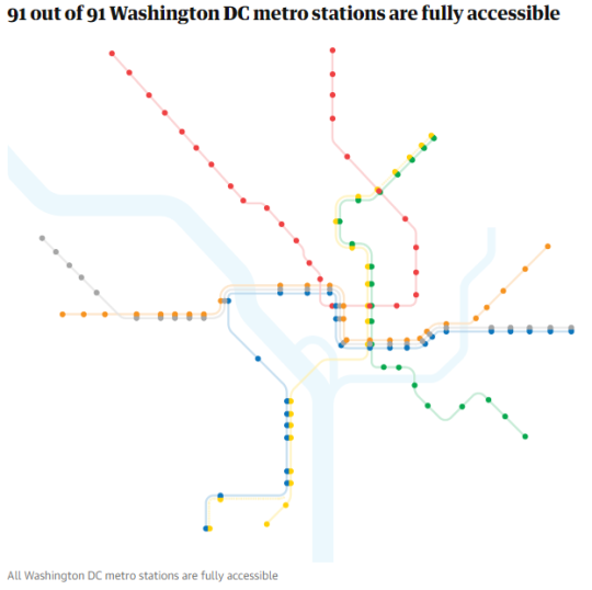
Source: The Guardian
34K notes
·
View notes
Photo

Los Angeles’ light rail system in 1912
46 notes
·
View notes
Photo

The railway system of the Habsburg Empire.
149 notes
·
View notes
Photo

#metrotransitarchives #moovit #chicago #illinois #downtown #streetphotography #portrait #masstransit #metrotransit #CTA #chicagotransitauthority #newflyer #diesel #hybrid #articulated #lowfloor #transit #bus #publictransportation (at Chicago, Illinois) https://www.instagram.com/p/Bz524_PHPE8/?igshid=p9zqnrzyjf8g
12 notes
·
View notes
Photo

#metrotransitarchives #moovit #toronto #ontario #canada #streetphotography #downtown #portrait #landscape #buildings #masstransit #metrotransit #TTC #torontotransitcommission #CLRV #streetcar #trolley #tram #transit #train #publictransportation (at Toronto, Ontario) https://www.instagram.com/p/Bz4yDYVnlF7/?igshid=1gc7g698dapbw
37 notes
·
View notes
Photo

Today I present another map of an imaginary metro area. Work began in March 2018 and concluded yesterday, June 20, 2018.
This isn’t my most complex map, but it was interesting to make - using strong corridors to provide defining geometry, ensuring that crossings were minimized and that it was always clear which line went where, etc.
Overall I’m pleased with the result.
4 notes
·
View notes
Photo

Moszkva Ter Metro Station (today Szell Kalman Ter) Budapest, Hungary, built in 1972
61 notes
·
View notes
Photo

Northern British Columbia public transport
30 notes
·
View notes
Photo

Today I finished a three day project, creating a map of an imaginary set of cities (for a Pokémon fanfic, but that’s besides the point).
Although I didn’t intend to, I ended up using colors similar to that of the Düsseldorf Stadtbahn for the light rail and the Delucape side ended up looking like what San Francisco might have been like if Market St didn’t exist.
Overall, I’m satisfied with the project. It’s built to my usual 8-16 spacing scale and the station icons are quite sufficient (inspiration taken from Urbanrail.net). Transfers look nice as well, although some things were squashed in due to space restrictions.
DIN worked well as a font too - I think I prefer it over Source Sans Pro. And in the end, I only had one portion of the map at a 45 degree angle for anything other than a curve, which I believe to be a success (reason being that my station icon can’t handle transfers gracefully on a 45 degree angle).
1 note
·
View note
Photo

Bus terminal in Eger, Hungary Built in 1968, Designed by János Dianóczky, Dezső Detre. © BACU https://www.instagram.com/p/BvzcVfdHvjC/?utm_source=ig_tumblr_share&igshid=1fks5czkx1bz4
57 notes
·
View notes
Photo

Another map of an imagined metro area. Work started in September 2017, but slowed down until it was rebooted February 2018 and finished by March.
The two main things I experimented were on this map were a new set of terminal stubs and having different colored lines merging. I think I was moderately successful with both.
1 note
·
View note
Photo

Predeal Railwaystation, 1969 Arhitects Irina Rosetti and Ilie Radulescu
21 notes
·
View notes
Photo

Historical Map: Moscow Metro, 1980
Here’s a beautiful map of the Moscow Metro from 1980 that’s unlike anything else I’ve ever seen. I don’t think it’s an official map, as it looks quite different to other Moscow maps of the same vintage. The archive I found the map in also lists it as “Source Unknown”. It appears to have been printed on the flyleaf of a pocket-sized book, bound to the book’s front cover on the left half, with the fold just to the right of the vertical Orange Line of the map.
Have we been there? No.
What we like: One of the most unique-looking transit maps I’ve ever seen. It looks more like a map of the solar system, with Jupiter-sized interchange stations within the orbit of the Ring Line, smaller satellites (outlying stations) trailing along in their wake. Despite the unusual form, and the renowned complexity of the Moscow system, this still has a nice sense of clarity, simplicity and order to it - this map is still very usable.
What we don’t like: Some absolutely terrible registration on the printing (which appears to be all spot colours - nine different colours in total!). Some fairly crude-looking linework, which may be poor draftsmanship or the result of the printing.
Our rating: Totally unique, but still a very usable map. Four stars.
(Source: Lebedev Studio’s historical archives of Moscow Metro maps)
Click here for another abstract Moscow Metro map.
200 notes
·
View notes
Photo

PKP Warszawa Ochota, (Warszawa Ochota railway station), Warsaw, Poland, built betwen 1954-62, Architects Arseniusz Romanowicz, Piotr Szymaniak. © BACU @_ba_cu #_ba_cu . . Map location: http://socialistmodernism.com/ . . Add new sites: http://socialistmodernism.com/add-locations-visitors/ . . Use the #SocialistModernism tag for the possibility to have your #SocHeritage shots featured. All information thus collected will be published on our website.
43 notes
·
View notes
Photo

Belorusskaya-Metro station Moscow, Russia, opened in 1938, architects Ivan Taranov and Nadezhda Bykova © BACU #socialistrealism
14 notes
·
View notes
Photo

Train passengers in France, 1889
81 notes
·
View notes