
kentuckyfieldguide
Kentucky Field Guide
A single dad's guide to hiking and traveling, even when it's hard to find time to hike and travel.
20 posts
Don't wanna be here? Send us removal request.
Last Seen Blogs

quickdirtypress
Quick & Dirty Press Co

forteintofinale
Forte into finale


this-hattan-newsie
kumaora

atripinmymind
Viaggia nei posti più reconditi della mia mente
Text
Backpacking Pine Mountain’s Highland Trail
Months in advance of the Kentucky derby weekend, I invited my friend Michael Larimore to accompany me on a backpacking trip to Pine Mountain in eastern Kentucky. I recently signed a contact to write my first article for Sierra magazine on the trail, and so we undertook a 16-mile trek over the Highlands portion of the Pine Mountain State Scenic Trail.

Friday morning we set out from Louisville on a four-hour drive, the weather promising rain. Weparked at Pound Gap, straddling the Kentucky/Virginia border. The beginning of the trail is within the boundary of the Jefferson National Forest. Here’s a brief synopsis of what you can find there.
A little more than a mile in, there are four camping pads at the Jack Sautter Campsite. We dropped out packs here and headed downhill a quarter mile to the Old Meade homesite--not much left of it, I’m afraid, but there is a lovely marshy meadow. Another 3.5 miles in we crossed Laurel Fork in Indian Grave Gap and came upon the Indian Grave Campsite.
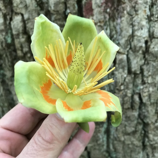
Along the way, we passed rocky fields full of flowers, such as the painted trillium and yellow lady slipper orchids, among others.


We donned our ponchos in a light rain, passing the Rock Fortress and counting efts--juvenile newts--of which we counted thirteen. We climbed to an overlook at Twin Cliffs and saw, not far from it, what must have surely been a bear cave.


The remaining two miles found us caught in a steady rain. We got wet, to our chagrin: pants, socks, and footwear, mostly. But we arrived at the Arena Springs Shelter safely, and only a tenth of a mile past the shelter, we found an excellent water source--a spring channeled into a pipe.

The night proved unruly. Powerful winds swept over the peak, roaring. Rain--or was it hail?--pelted the metal roof like stones. Temperatures dropped into the forties that night. Michael and I were geared up well, with spare clothes and good sleeping bags. We were duly surprised when, at nine o’clock, in the pitch dark and rain, a headlamp announced that a prosecutor from Virginia had ambled into camp. He’d walked eight miles from the opposite direction, mostly in the rainy twilight.
The next morning, Michael got a fire going, using cotton balls soaked in Vaseline as firestarter. We dried our clothes, and not without some clothing casualties (I lost a sock and melted bits of my pants, and Michael burned a hole in his warm hat). We continued on toward Flamingo Shelter. The first day had proved rugged but fairly straightforward. The second day was the most difficult, by far.

The Highlands section rises and falls, sometimes precipitously, depending on your endurance and how in shape you are. Or think you are. The second day found many traverses of wet sandstone which, when covered with rock tripe and lichen, can be slippery to the point of injury. Crossing Mars Rock, for instance, socked in, a white mist blowing over the peak, with rain falling all the while, was treacherous. (Beforehand, we had stopped in a rock shelter beneath a series of cliffs to have lunch and wait out the rain. Lunch worked. Waiting out the rain didn’t.

We also crossed Slip & Slide Rock, as seen above, which is where the Swindle Campsite is located--the only place to camp in this stretch of trail, which is the Bad Branch State Nature Preserve, a joint effort between the Kentucky state nature preserves commission and the Nature Conservancy. When the rain started, we were so eyes-to-the-trail that we missed High Rock altogether. But we did see groves of pink lady slippers and rosebay rhododendron.


After some eight miles, we finally arrived at the Flamingo Shelter, which is built exactly like Adena. I arrived dry, amazingly. Michael set up a shelter, in case it rained.

The next morning, we watched eastern phoebes, which were nesting in the eaves of the shelter. I identified a blue-headed vireo to my satisfaction. And in the morning, a hooded warbler came down to the table.

The woods were full of all these birds.
The walk out--and the last day was sunny, and stayed that way through Monday--was less than a half mile. We used the shuttle service provided by Pine Mountain Shuttle, LLC to get back to Pound Gap. Our driver was Bill Ramey, Vice President of the Pine Mountain Trail Conference.
The long and short of it: this is a challenging trail, but rewarding. Views over both Virginia and Kentucky’s Cumberland Plateau abound. In May the wildflower show is stunning. We saw no bears, but certainly bear signs--droppings, for the most part--and at any rate the shelters feature pretty tall bear poles to hang your food and garbage. We were unmolested, thankfully. We did the whole section in only two days, though one could slow down to three or four. Taking your time, you can also explore the Bad Branch preserve, with its own 8-miles of trail.
Happy hiking!
2 notes
·
View notes
Text
Spring Flowers, Part Two
For the last few weeks, I’ve been training for a backpacking trip on the Pine Mountain State scenic Trail. That simply means that I’ve been hiking the Knobs around Louisville with a backpack on, loaded with all my gear. The new Osprey pack I picked up at REI has been serving me well. Today I gave myself another opportunity to see what’s been flowering in April.
I drove up Holsclaw Hill to the Horine Section of the Jefferson Memorial Forest. I set out to do a 6.0-mile loop on the Red Trail and the Orange Trail, which makes three descents to streams that feed into Knob Creek--which means, of course, three ascents, as well. But what a beautiful day, the temperature in the 50′s and 60′s, cool with spots of rain.
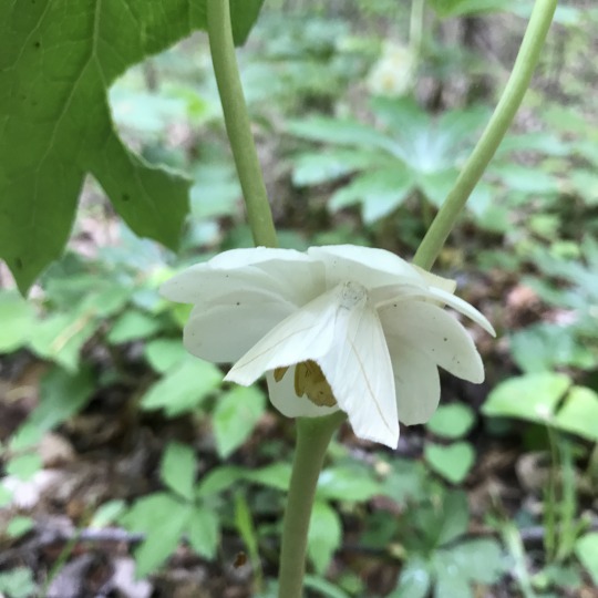
The first colony I found was of the mayapples I wrote about last week--but these had an added discovery. Here is the flower itself:
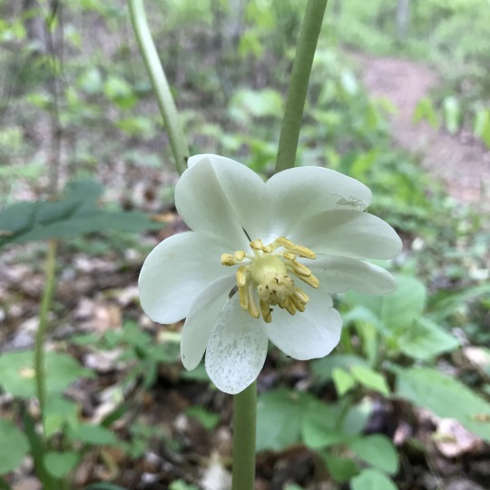
Note the little white spider, virtually camouflaged. Now look at this picture of the flower:
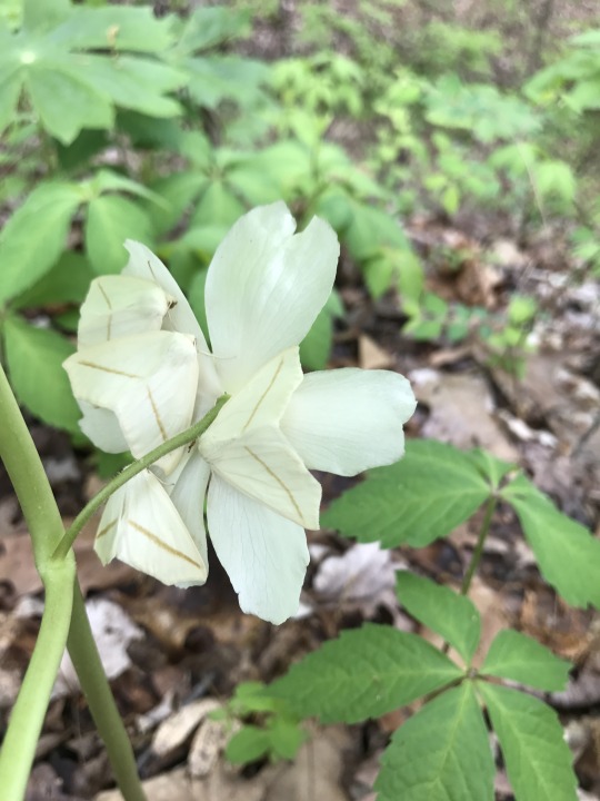
Do you see the oddity? Here’s another picture:
What looks like a flower petal is actually a camoflaged moth! This is the Pale Beauty, Campaea perlata, The first time, and only time, I’ve seen them are on the flowers of the mayapple.
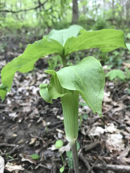
Also in the woods, as I also showed last week (and this is a better photo), is the jack-in-the-pulpit:
On the slopes of the ravines and along the creek bottoms are an assortment of flowers.
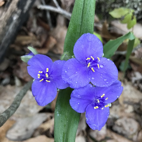
Spiderwort (Tradescantia virginiana)
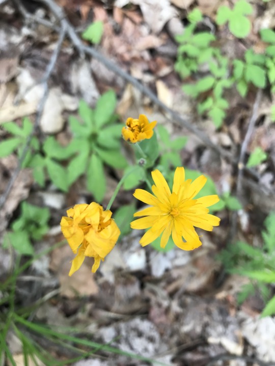
Yellow hawkweed, or King Devil (Hieracium pratense)
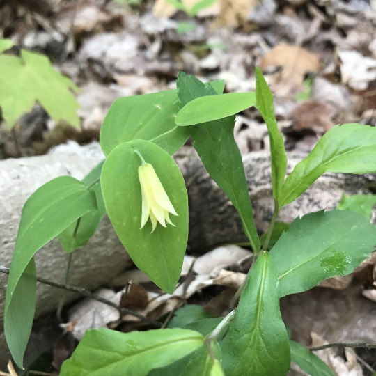
Smooth Solomon’s Seal (Polygonatum biflorum)

Another view of Solomon’s Seal
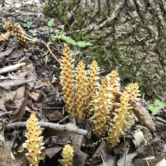
Squawroot (Conopholis americana)
Tulip poplar (Liriodendron tulipifera)

Sweet white violet (Viola blanda)
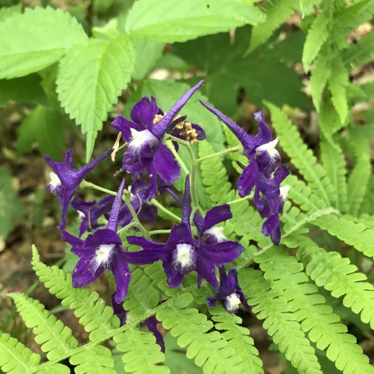
Dwarf Larkspur (Delphinium tricorne)
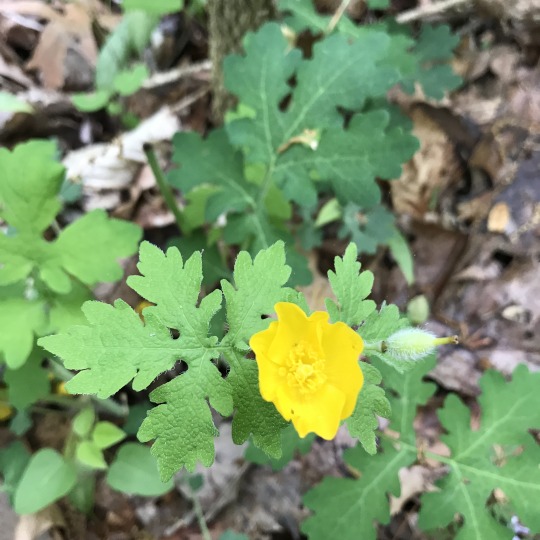
Celandine poppy (Stylophorum diphyllum)
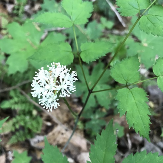
White baneberry (Actaea pachypoda)

Large yellow wood sorrel (Oxalis grandis)
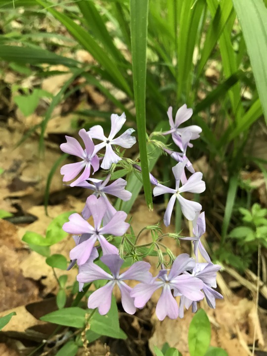
Wild blue phlox (Phlox divaricata)
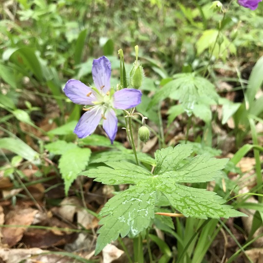
Wild geranium (Geranium maculatum)
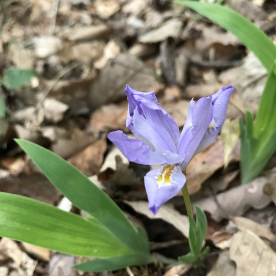
Crested dwarf iris (Iris cristata)
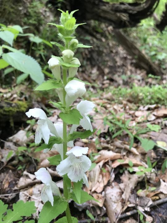
Guyandotte beauty (Synandra hispidula)
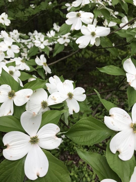
Flowering Dogwood (Cornus florida)
There were other sightings, as well. First, I saw a wood thrush in the forest atop the Red Trail’s sandstone ridge. Along the creek, I spotted a hooded warbler--I am lucky to have seen it. And driving out in the late afternoon, a wild turkey ran across the road, passing three crows milling in a field.
I hope you enjoy the flower show.
0 notes
Text
Spring Flowers 2017
It’s been a long winter.
For me, the final stretch of the season was spent in Vermont, where I worked on my book about Pine Mountain. Why Vermont? Because the Vermont Studio Center accepted my application to come write there for a month. It was fantastic, true, but I also waded through a nor’easter that dropped two feet of snow, and probably more, in the course of two days. It never stopped snowing for those forty-eight hours.
Granted, it was lovely and, let’s face it, nostalgic to see such powdery snow and even, on occasion, to shovel it. Walking along the Lamoille River on snowmobile trails to waterfalls and outcrops of schist and looking at hooded mergansers was a beautiful way to spend an afternoon. In the end, I got stir crazy. It did, after all, drop to around -8 degrees. I looked forward to coming home to see the wildflowers.
On my first Sunday back, Kate and I went to the Bernheim Forest. The Elm Lick Trail, to be exact. I’d been there last year to find fawn lilies (also known as “trout lilies” or, unexplainably, “dogtooth violets”), bloodroot, and several species of violets. Despite the fact that most trees were without color--the redbuds were the notable exception--the flowers were blooming heavily in the valley of Elm Lick Creek. Up on the ridges, bluets were blooming, sometimes in tufts--they are so small, however, that it is difficult to photograph them.
Here’s some pictures Kate took:

Rue anemone (Thalictrum thalictroides)

Star chickweed (Stellaria pubera)

Downy yellow violet (Viola pubescens, and there were also purple and white violets)

Dogtooth violet (Erythronium americanum)

Bloodroot (Sanguinaria canadensis)

Bloodroot, again.
Today I hiked Scott’s Gap in the Jefferson Memorial Forest (I’ll do my best to cover these; you may know how finicky iPhone’s are at flower shots, which is to say, close-up’s). In addition to redbuds, the dogwoods were blooming. Along the creek, and on the ridges, flowers flourished. Here’s a few more that I shot:

Paw-paw (a tree, actually, Asimina triloba)

Fire pink (Silene virginica)

Dutchman’s breeches (Dicentra cucullaria)

Spring beauty (Claytonia virginica)

Celandine (Chelidonium majus)

Blue cohosh (Caulophyllum thalictroides)

Trillium (the dwarf wake robin, I believe, Trillium pusillum)

Toadshade (Trillium sessile)

Carolina larkspur (Delphinium carolinianum)

Mayapple, which is thriving in large colonies (Podophyllum peltatum)

A bit blurry, but you get the point: Jack-in-the-pulpit (Arisaema triphyllum)
Though it wasn't yet flowering, I believe I also saw wild ginger (Asarum canadense). There were also geraniums (Geranium maculatum), and, as mentioned, the bluets (Houstonia caerulea).
Now is the time, especially in The Knobs (which both Bernheim Forest and Jefferson Memorial Forest are a part of), to see the flowers. Many trails are easily hiked after work, as much as of a Sunday afternoon.
0 notes
Text
The Ravens of Pine Mountain
Read this special piece, something new for me, in Nowhere Magazine. My thanks to Porter Fox and Kim Stravers for the publication!

0 notes
Text
Pine Mountain, Winter (Part One)
(The Pine Mountain Narrows)
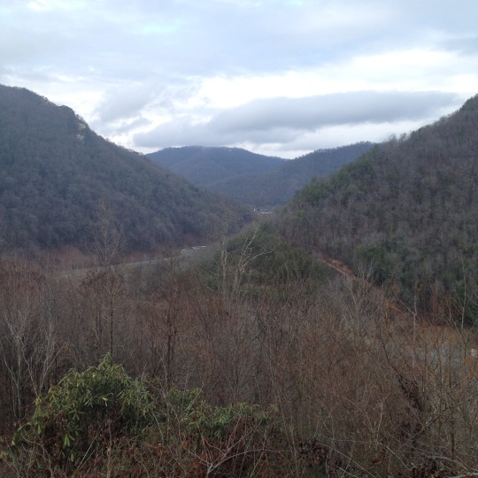
When Kate and I arrived at Pine Mountain State Resort Park on Christmas Day, the weather was unseasonably warm. The rain that had fallen all morning over Eastern Kentucky dwindled by the time we reached the Narrows Overlook, a half-mile climb that the state park calls “strenuous” but which we decidedly determined to be “moderate,” if not “easy.” As we started up the old roadbed that marked the trail grade, the sun even began to peek out. We walked in T-shirts.
I was there to do a bit of research, to walk the actual ground where Dr. Thomas Walker first saw what was known as the Shawnee River, which he renamed the Cumberland. After he found the river, he continued on his westward journey into present-day Kentucky through a breach in the 125-mile long Pine Mountain.
The Pine Mountain Narrows is the point where the Cumberland River cuts through the mountain, creating a water gap that has been traversed by everything from prehistoric buffalo to Native American tribes (notably the Shawnee and Cherokee), as well as the thousands of emigrants who traveled the Wilderness Road. From the top of the overlook, we looked into the break in the mountain. Just before the break is where Clear Creek enters the Cumberland River; this is where Walker, under the employ of a land company he helped found, named the river just before he and his men entered the Cumberland Plateau--not the first man to do so, and not even the first white man--only the first to write about it.
From here, Walker would begin to survey the interior of present-day Kentucky, claiming land for his colleagues back in Virginia. The journey, at least by his standards, would prove to be unsuccessful. He saw only rugged, mountainous land for months.
Kate and I were there for a different kind of discovery. The sky continued to clear as we drove up the south face of the mountain into the state park. We headed to Chained Rock (which I’ve written about previously here), which Kate had never seen. I wanted to hike down the Laurel Cove Trail, a downhill path I’d never been on. I was looking for Powderhorn Arch. The sky was increasingly blue through the bare trees, and we watched rock outcrops for the arch (we didn’t realize that the trail went directly under it further down the mountain, and so were peering at rick outcrops for any sign of it). We marveled at the rock outcrops and cliffs, and followed a creek down a stunning slide of waterfalls. A red eft--a juvenile newt--scuttled slowly through the leaves.


(photos by Kate Spencer)
At a rock outcrop I was examining a pitch pine--I identified the three-needled pine on the spot, clearly different from the Virginia pine--when I slipped, tearing one of my fingers open. A bit bloodied, I washed my finger in the creek and we figured we’d best climb back up the mountain to the car. We didn’t make it to the arch.
A few days later, the temperature in the 60′s, we went back up to the park to see Honeymoon Falls. A windstorm must have passed through; we’d seen damage on other parts of the mountain but didn’t expect to have trouble on the short walk to the falls. After a night of heavy rain, I wanted to show Kate the falls, one of the most heavily used trails in the park. First, we had to ford the creek, and the water was high. Then, at yet another ford, our way was blocked by a large fallen hemlock, which had also smashed into the creek, making crossing impractical and likely dangerous--crossing wet wood is never a good idea. We abandoned the trail and went to the lodge for lunch instead.
Outside the windows, dark-eyed juncoes, also called “snowbirds,” pecked around beneath the feeders hung outside the windows. The view from the restaurant extends, on a clear day, to Tennessee, more than ten miles away. The sun was bright, the sky clear, the weather warm. A beautiful day for hiking, though I wondered at the effect of such warm weather on the mountain.
Walker was looking for land and wealth. What do we go to the mountain for? Peace, for one. Yet it astounds me how Walker passed through the mountain without seeing some of its wonders: the arch, the waterfalls, the coves. For that, one must tarry, as it were. Linger. Examine. All this Kate and I would attempt to do on another stretch of the mountain the day after Christmas.
For my next post, I’ll write about the Pine Mountain Trail, the hike we did during this same trip where the temperature soared to 66 degrees on December 26.

(Photo by Kate)
0 notes
Text
Red River Gorge, Winter

Today I had the good fortune to have an essay accepted for publication in Appalachian Heritage, a journal published out of Berea College here in Kentucky. Having worked on the piece for quite a few weeks (the piece itself was a few years old), it got me to thinking about “The Gorge” again.
Despite the fact that the weather has turned cold and the first spare flurries have fallen, the Red River Gorge is an excellent destination. When I was researching for my guidebook, Hiking Kentucky’s Red River Gorge (which really means, “when I was hiking”), I spent most of my time sojourning in the Gorge in the summer and autumn months. Naturally, one sees the most people at that time, whether on the trail or in the Koomer Ridge Campground. It’s in the winter months that the hiker might find some solitude.
Different weather makes for different conditions. For one, when the largely deciduous forest has lost its leaf cover, much of the Gorge is revealed for its stunning cliffs. Coming down the Sheltowee Trace in December, one can easily see such landmarks as Cloud Splitter. Hiking to Double Arch, you will pass high walls hung with massive icicles.
That said, the Gorge can also be treacherous in the winter because of said ice. When the ice covers the trail, especially on the steep slopes along the trails between the Indian Steps and Indian Arch, for example, one slip could mean an almost certain injury. On some cliffs, one can expect far worse. By all means, be careful.
I took my daughter Teagan on a particularly cold day last year. In the night, the temperature fell to below freezing. We had found one of the last spots in Koomer Ridge Campground, to our luck, and we had brought my brand new tent and winter sleeping bags. Plus extra blankets. And of course we built a fire.

(Teagan by the fire at Koomer Ridge Campground)
Which brings me to today’s entry: a good place to take kids (and yourself) for an easy exploration of the Gorge. The Koomer Ridge Campground, located in the Red River Gorge Geologic Area in the Daniel Boone National Forest, has 54 sites for year-round camping. With warm gear, winter is certainly an option--and anyway, campfire wood is readily available in not only the campground but at various points along the roads throughout the Gorge, where locals make money on their woodlots.
Note, however, that these developed campsites--the only ones in the Gorge proper--cannot be reserved, but are on a first-come, first-serve basis. This can make, consequently, for an enormously frustrating experience, especially in the summer and fall, when you might drive for hours only to find no available sites. The fact that the campground has a bathhouse with hot showers (though this bathhouse is closed in the winter, while vault toilets remain accessible all year) makes it an enormously popular choice. The sites themselves are far more private than, say, the sites at nearby Natural Bridge State Resort Park. But in winter, you can expect far fewer crowds. But dress warm.
The campground has several trails that start among the campsites. The half-mile Cliff Trail #206, a short but scenic National Recreation Trail, skirts the edge of some formidable cliffs, and not all of its stretches are guarded by the stone wall. Keep children close. This trail connects, too, with the Silvermine Arch Trail #225, a 1.25-mile trail that heads along a wooded ridge and down a cliff (via a stairway) to its namesake limestone arch. Again, keep children close.

(Teagan with a big-leaf magnolia leaf, by a rhododendron grove)
An excellent hike for kids is a roughly three-mile loop along Koomer Ridge, visiting Hidden Arch. I wanted Teagan to see Hidden Arch, one of the finest in the Gorge, as much as I wanted her to be careful. Note that there are certainly imposing cliffs along this loop. Teagan was 6 when we did it, and I trusted her--though I remained anxious and on guard.
The hike begins at the backpackers campground, on a spur road just west of the main campground (this can be accessed by either the road or the Silvermine Arch Trail, which runs along the wooded ridge between the parallel campground roads). Strike out on the Koomer Ridge Trail #220 and, in a short distance, watch for the Hidden Arch Trail #208 to the left. Head towards Hidden Arch; the trail parallels the Koomer Ridge Trail for a distance, then heads out a ridge. At the farthest point, the trail descends a wooden stairway to Hidden Arch; why “hidden”? If you were coming from the other way, you might miss it, I suppose, if you weren’t paying attention.
Here’s Teagan standing in Hidden Arch, which isn’t quite as frightening as it looks:

But it does look a bit frightening, now that I think of it...
Nevertheless, this is a good place to stop and have a snack. The trail at this point also sits beside a rock shelter and looks out over a creek valley, one of the branches of the Right Fork of Chimney Top Creek. The trail skirts this edge then climbs back up to the Koomer Ridge Trail where, I’m told, you can find yellow lady slippers come spring. Turn right on Trail #220 to go back to the campground.
Now, if you’ve got a bigger and more adventurous kid--and if you have a map (a basic one is on the Forest Service website, though as always I’d recommend the more thorough topographic map that the Forest Service publishes and sells)--you can continue on deeper into the Gorge. The Koomer Ridge Trail descends the ridge and connects with the Buck Trail #226, the Sheltowee Trace #100 (which spans Kentucky north to south) and the Rough Trail #221, which allows for an even bigger, secondary loop, if not a backpacking adventure.
If you find yourself needing a guidebook, you can certainly buy my Hiking Kentucky’s Red River Gorge--an excellent Christmas gift, I’m told--from REI or my publisher, Menasha Ridge Press (where it seems you can save 25% right now).
Happy hiking and happy holidays!
0 notes
Link
This is an article I recently wrote on the Pine Mountain fires.
0 notes
Text
The Citizenship of the Forest

On the Sunday following the election, I went to the woods.
Kate and I drove to the Jefferson Memorial Forest. We parked in the overflow lot across from the visitor center; it was a beautiful autumn day, and there were clearly plenty of people there to hike the trails or fish Tom Wallace Lake. For our part, we planned on hiking up Yost Ridge and down to Mitchell Hill Lake.
We set out, passing all the people who’d come for the new ropes course that was installed behind the visitor center, and started up the Yost Ridge Trail. We walked slowly, noting all the trees. There were still leaves, though many have fallen. We passed beech, white oak, and sassafras on our way to the ridge, from which we could see all the way to downtown, ten miles away.

We puzzled over the oaks, trying to distinguish the black from the northern red. I am confident by now in my ability to identify the sugar maple, the various hickories, and the Virginia pine. I also have a grasp of the various stone; we poked at the crumbling shale and the hard stratum of limestone and determined, to our satisfaction, the constitution of the higher ridges.
As we approached the lake, we passed several fisherman. They greeted us with courtesy. We passed a runner who said he’d seen a “blacksnake” (a black racer, no doubt) on the earthen dam. We helped some college kids get their bearings when they missed a trail junction. The forest was filled not only with people but different people. I’ve always noticed that the people who walk in the Jefferson Forest span all manners of race and culture, of age and gender. The forest is something shared, a heritage we hold in common.

I have thought about this in the week following the election. The presidential race suggests, if one looks at the numbers, that the country--or at least those who voted--are divided, nearly equally. The race, by any measure, was contentious at the outset. As we passed people on the trail--and as we’ve passed people in the grocery store, in our neighborhoods, at our workplaces--it was hard not to ask, quietly in our minds, who did they vote for?
This is a question not so easily reduced to whom they might support in polls, in races spanning from local school boards to state senators. It calls to mind, rather, many questions: what do these people stand for? What do they support? What do they value?
What was evident to me was that all of these people valued this place, this forest. The fishermen valued it for what they might catch in the lake, the hiker for the respite. Kate and I valued it for the opportunity to enjoy the day, to learn about the trees, to understand where we were, where we live, the landscape we owe our lives to. It seemed irrelevant to discuss political differences in the context of towering trees that rustled in the wind, the sunlight on us, the people happy to be there.
When Kate and I stood, staring into the treetops, people would follow our eyes upward and ask what we were looking at. They were interested, they wanted to know. And we’d tell them, we were trying to learn the trees. I thought of the quote by Wendell Berry, printed on a coffee mug that Kate bought me: “What I stand for is what I stand on.”
I thought, unification can begin anywhere. What better place than this forest we all love? If there is anything that unifies us, it might be this ground we all come to for respite, for quiet, or simply to walk. We might vote for people who like-mindedly want to preserve places like this.
I now believe I must turn my attention toward identifying the people of this place, as much as some of them may puzzle me. If we can all agree that what we stand on is what we stand for--be it limestone or leaf litter, farmland or mountaintop, city park or wilderness area--we might find, quite literally, common ground.
(Photos by Kate Spencer)

0 notes
Text
Trashing Cumberland Falls
It was mid-October when my daughter and I first visited Cumberland Falls State Park in southeastern Kentucky. A Friday morning, cool and cloudy. It was hard to tell the rain from the fall’s mist. Arriving at the lot, we saw the same unfolding landscape anyone would: following the river downstream, walking out on the rock shelf. The sound.
We followed the white turtle blaze of the Sheltowee Trace, the 282-mile trail that crosses Kentucky, past the gift shop and the interpretive center to the first overlook. From there, we stood where thousands have stood, overlooking the 125-foot-wide falls falling seven stories over 250-million year old rock. The “Niagara of the South,” where certain tribes lived in caves along the banks as far back as 10,000 years. A sacred place to the Cherokee, Chickasaw, Shawnee, and Creek nations.
Currently, parts of the overlook are closed for repairs, a worthy investment as far as state parks go, but we went to each of the cascading overlooks that remained open, fashioned of stone walls and wood railings, to the terminal stairway that led down to a sand beach. It seems almost redundant to describe Cumberland Falls, especially if you are from Kentucky; the falls--famous for its monthly moonbow, its 65-foot plunge--have been photographed innumerable times. The falls are, any way you look at it, iconic.
It is roughly confusing, then, to understand the sheer amount of garbage at the site. The beach is littered with plastic bottles and so on, and strewn among boulders larger than houses is even more trash.
Coming back up from the beach, Teagan and I spotted what looked like a shallow cave, or a rock shelter. Looking inside, the ground was nearly covered with trash. It was a disturbing sight. Even Teagan, seven years old, commented on how stupid people are. Besides the obvious question--why on earth would someone do this?--there is the question as to why the trash has not been cleared.
I first met Sherry Cornett, the park manager of Kingdom Come, while she was out the day after Labor Day picking up trash by herself. I later asked her, in an interview, why she thought people littered on these amazing places. Her answer was fairly simple: ignorance. Because kids throw trash on the ground and the adults say nothing. Because adults throw trash on the ground and the children see this. A vicious cycle.
Anyone can see why such a sight as Cumberland Falls, the only waterfall of its kind in Kentucky, would have been sacred to people for 10,000 years. it still is sacred, in whatever way modern people define that. Those modern people drive for hours to see it, spend money to stay in the lodge, and eat in the restaurant overlooking the Cumberland River. Some follow the half-mile trail though the forest to the overlook, some drive the paved road down. But they come, and many, it seems, leave something behind for the rest of us to witness and lose hope over.
This was the weekend that Teagan and I went to the Pine Mountain Settlement School for the Fall Colors weekend. Three days after we left, someone, or a number of people, started a fire along a four-mile stretch of the Little Shepherd Trail on the ridge above the school. The maintenance staff, and later the Forest Service, fought the fire. Luckily, it burned mostly along the ground and didn’t rise into the crowns of the trees. It could have done worse; the late summer and fall were dry for a long time. The fire, after a week, is finally being extinguished.
To say anything of this is to risk stating the obvious. To leave trash at what amounts to a holy site is to render the site merely a postcard, a picture of the falls from which we stand away, as in a theatre, dropping popcorn on the floor. Perhaps we think someone else will pick it up, though invariably, during flood stage, the river itself will carry our garbage downstream, strewing it throughout the national forest, polluting the river at Nashville, further burdening the Ohio.
When we enter the forest, which is to enter the world, we cannot blame the oil companies for exploding pipelines when we ourselves do the same damage, no matter how small and insignificant we think our acts may be. We cannot expect clean water otherwise. In a culture that is, in some respect, paternalistic, the oil companies become the parent figure we all see degrading the landscape, and out of ignorance, we do the same. This may be true, or at least partly. But this kind of disregarding culture begins with us, our minds, and the more we create the pathways in the brain that say, I will leave this garbage here, entirely ignorant of who comes after us, whether it be me and my child looking for unsullied land or anyone else, then the culture will continue.
Of course, we must look into ourselves and ask how it is we value the land. Cumberland Falls is a place of power: the strength of water and the resistance of stone is on display for us to wonder at and, perhaps, to find within ourselves. In reality, the waterfall is simply a natural occurrence. It has no meaning beside hydrology and geology. It is we who assign the meaning. What we have assigned to it is that this place is a destination, an isolated event worthy of our camera, an oddity of sorts. We have long thought of places in the wilderness this way, and I mean only to suggest that Cumberland Falls is more than this.
The falls are a living event, the entirety of the scene, filling the senses. The cliffs, the boulders, the groves of rhododendron, the driftwood are all part of the falls. They are dependent on the weather, the sky and the rainfall--even the moon, which for four days, for only hours at a time, casts a bow seen nowhere else but one other place in the world. It’s not that we can stand hundreds of feet away and see, in the distance, the falls on the Cumberland River and say, there is the falls over there; I have seen them. Rather, standing any distance away, you are in the falls themselves, a part of the totality of this place. You feel them and thus are them
When you stand beside the falls, you too are part of the scene. You are a part of the world at that moment, the world that is Cumberland Falls. If they are holy, and they are, then you too are a part of that holiness. Perhaps it is idealistic to want people to approach such places in silence, in a state of reverence. To my mind, we should do this. We should speak quietly around the falls, so that all who come before them might hear only the sound they make. We should bow before them, and allow others to do the same. At the very least, we should keep the place clean.
The Sheltowee Trace follows the edge of the river. Two more waterfalls--Eagle and Dog Slaughter--lie each on either side of the Cumberland along hiking trails. One must imagine the people that will come, no matter how far in the future, and who will ask, is this who these people are? Or were?
In no way am I disparaging the work of the state parks, nor the people who labor there. They operate on a limited budget, which is only one more reflection of our misplaced values. They do, as Sherry Cornett and her employees do, what they can. Anyone can go to the falls with a bag and remove the trash; indeed, we should. It is extensive work but work that would be accomplished with the steady roar of the falls in our ears, the enormity of the forest in our eyes and at our fingertips.
We might come to feel, as much as we feel the thundering of the water in our feet, that we are making the place sacred again for all who follow.

0 notes
Text
Autumn on Pine Mountain

When I say “exploring,” what is it I mean? Recently, it has meant exploring consciousness and its relation to the natural world, the environment, whatever you might call it. Under this aegis, I have been traveling to Pine Mountain for some time; my first visit was in the winter of 2014, hiking along the ridge above Whitesburg toward High Rock. In the ensuing time, I have made many discoveries.
This past weekend, the Pine Mountain Settlement School hosted their Fall Colors Weekend, as they do every year. Founded in 1913, the settlement school began as a school for the children of miners throughout Appalachia; today it serves as an important community education center for adults and children from anywhere, specializing in environmental education. With the James Bickford State Nature Preserve directly adjacent to the school’s property, which was donated entirely by William Creech at the turn of the last century his cabin still stands, a designated state landmark), Pine Mountain offers itself to the one’s deepest interests and imagination.
For about five months, PMSS has been graciously hosting me as I work on a book about the mountain, offering me a base for exploration. When I told Geoff Marietta, the executive director, that I would like to write some about the school as well--for its presence, to me, seems inextricable from the mountain it sits beneath--he invited me to attend the autumn weekend, on the house no less.
So I took my daughter Teagan to eastern Kentucky, keeping her out of school for a day (an absence excused by the fact she can write about what she did, particularly if the day entails education, as it did). We arrived for dinner on a Friday evening, where we joined a group of, I believe, 19 other visitors of various ages, many of whom made this a yearly event.
After dinner we were treated to a presentation by Mark Whitaker, who works in the Letcher County Wildlife Rehabilitation Center, who showed us no less than four raptors: a great horned owl, red-tailed hawk, turkey vulture, and screech owl. He taught us each of the birds’ adaptations, carefully explaining how difficult their survival is, especially in winter. Four out of five owls, for example, do not survive their first winter. the opportunity to see the birds close up, to be caught in their gaze, was invaluable. Teagan enjoyed it and, later, wrote about it.
The following day, PMSS educator Amanda Wiley gave a workshop on nature journaling, using her own to demonstrate the two main methods of keeping a journal: writing and drawing. We were encouraged to do a little writing and drawing ourselves. I had in mind Thoreau’s journals, which I’d been reading about and wished to read for myself (having only read Walden), while Teagan, remembering the demonstration of the birds the night before, drew and colored the differing feathers of the hawk and owl. I wrote about the birds, their numerous faculties. We were even given a journal to go home with. Teagan and I decided to carry ours to Kingdom Come State Park, where we’d be headed later that morning.
The air was cool, in the 50′s when we departed. We drove into the park along the Little Shepherd Trail, the paved one-lane road initially built by the Civilian Conservation Corps doing the Great Depression. We stopped at the Bullock Overlook across from the park headquarters. The wind was cold and strong, blowing over the lip of the mountain and rattling the trees. It was a cloudy day, and though we could see the colors we’d come for, they were not yet lit with their full vibrancy.
We started down the Possum Trail toward Raven Rock. Along the way, we paused with the naturalists who accompanied us to admire the plants: striped maple, gentians, and galax. We chewed teaberries, sassafras leaves, and sourwood leaves. We paused on a steep rock outcrop where Teagan played in the sandstone potholes, filled with water, among the patches of moss. At that point, we were crossing a burn, where a fire burned over 200 acres in the park in April, 2014. The forest is recovering nicely, the naturalists commented.

We headed off on the Ivy Trail, where I’d not yet hiked. We paused at a pine tree, the bark clawed off and, stuck in the sap, bear hairs twisted. A spur led to Knife Ridge, a slim sandstone ridge marked by a coyote scat and the red leaves and dangling flowers of sourwood. The view extended over the south face of Pine Mountain. We continued down through the mixed mesophytic forest to the lake and the visitor information center.
Of all the hikes I’d been on, I’d often regretted not taking the extensive notes I’m sure I’m capable of. Often, I will take photographs to remember a particular plant, or stone, or scat. I do make brief notes in my pocket journal, which later I transcribe into the narrative portions of my book’s draft. The secret to journalling is this: one’s memory of their being conscious of an order in nature is strengthened by simply writing one’s observations down. My book, therefore, is as much an exercise in awareness as it is narrative. The union of these two faculties is, of course, the imagination--or perhaps the imagination is a bridge between two orders of understanding, the transforming element between the exterior and interior world which unsurprisingly--at least when one is aware of their own weathers--mirror each other.
When we reached the shelter near the campground, we were treated to a picnic lunch. The day’s weather had not significantly improved. It was still cloudy and cold, though the sun broke through occasionally. it was the first taste of winter; indeed, the next day the visitors would wake to their cars covered in ice.
The last thing we did was to visit Log Rock, a natural sandstone arch. Teagan wanted to walk across it not once but twice, and though I myself can do so with impunity, walking behind a seven-year-old on a sloped surface over a decent drop is entirely unnerving and unnecessarily exasperating. But she was happy and rather proud of herself, to boot. Many of us went to an overlook behind the arch, now that the sun had come out more, to see Black Mountain before us and the town of Cumberland below us. Teagan and I sat together and watched the world pass.

(photo by Susan Brown)
I often think, especially when I reflect on my daughter’s experience in the world, though I can never know its depths to any satisfaction, how a child’s consciousness moves. At times, it seems to take in the wholeness of a place, as when Teagan challenged herself to crossing Log Rock--it was the linear movement that held her imagination. Other times, it can pull away from the larger scene, as when Teagan sat on the sandstone slope, Black Mountain fully before her, the vast sky above her, her eyes and attention focused utterly on a single pool of water the width of her hand. We move in the same way, though it is the latter consciousness I feel I must focus on in my life. Too often, the wider view distorts the tiny impressions made in the soil by the toes of a white-footed mouse, a single agate caught in a block of rock, the rattlesnake plantain lying beneath fallen leaves.
The last thing we did, once we were back on the Little Shepherd Trail, was to climb up to the 12 o’clock Overlook, fashioned of stone and wood (I suspect it was built by the CCC, but I’m not certain). We took a group photo. We stared along the long line of the mountain stretching to the northeast. The entirety of the Appalachians stretched out before us. Teagan was content to play with a few twigs she wrapped in fallen grape leaves.
That evening, we were treated to a bluegrass concert courtesy of Sunset Ridge. A fire burned in the fireplace and a few people even got up to do the two-step. Teagan, for her part, played and read in The Little School, PMSS’s child care center in the lower part of the Laurel House, where we slept. For a long time, exhausted, I sat in a chair and watched her. I didn’t want to miss anything.
You can visit Pine Mountain Settlement School online and in person for one of their many seasonal events. From arts to music to environmental education, the Pine Mountain Settlement School has done much for Kentucky, and beyond. Test your own consciousness; see the mountain for yourself.

0 notes
Text
Full Moon Camping at Clifty Falls

I’d never stayed at the campground in Indiana’s Clifty Falls State Park. Because it is within an hour of Louisville, I thought it easy to take my daughter Teagan camping there. Now, there were some scheduling issues that weekend, and by the time I got around to reserving a site online (foolishly waiting until only a few days before), all the sites were gone, leading to a desperate search for any campground in southern Indiana and our region of Kentucky. Nothing.
Of course I was irritated with myself. Procrastination is not usually my mode, but circumstances interfered and, though I’d promised Teagan, I was suddenly without a spot on a night that happened to coincide with the full moon.
Lesson learned: if it seems like a good idea to go camping, everyone will think that.
Miraculously, after phone calls and searching, I gave Clifty Falls a second chance and, lo and behold, a site opened. Probably a cancellation. And for $30 and change, it was a good deal. Site 160 was mine.

So I packed us a couple tuna sandwiches, and Teagan and I headed north along the Ohio. The weekend promised to be clear and warm. We arrived at the north gate and paid our $9 out-of-state price (for Indiana residents, the price is $7) and headed to the big lot just inside the entrance. We had lunch among the sugar maples and yellow poplars then headed down to the beginning of Trail 7.
From this easy, 1.25-mile trail we could easily view Clifty Falls from two overlooks, one atop the cliff and the other below the cliff. the trail loops above the confluence of two creeks, past the monolithic Cake Rock, to a footbridge over Little Clifty Falls. By October, the leaves and acorns are falling steadily. We found beechdrops beneath the wooden steps, not to mention the litter people left behind--bottles, especially.
Teagan made a comment on the trash. She’s learning to be appalled at the fact. This makes me proud, in a sad way.
We also went to Tunnel Falls, which like the other falls was mostly reduced to a seasonal trickle. That fact aside, we were equipped with a headlamp (which Teagan insisted on wearing) and a battery-powered lantern to walk the length of the “cave,” really a tunnel carved out for an old railroad. The tunnel is closed from November 1 to April 31 to provide habitat for hibernating bats, so we made it in the last few weeks. The tunnel is not excessively long, but roundabout the middle, it is entirely dark. The ground is wet with seeping water and mucky clay, but is not particularly treacherous.

As much as I would have liked to go with Teagan further along the trails, we had little time. But as a note, there are a number of trails throughout the gorge of Clifty Creek. A trail descends to Hoffman Falls, the last waterfall in the park, and several trails both walk above and within the canyon along Clifty Creek. Fossils can be found throughout the park, including branch and horn corals. Do not take them.
A word as to the campground: I found it accommodating and pleasant. the bathroom (and this is important when one has kids) is modern and clean, equipped with showers. The sites maintain a level of privacy, and ours was crowned by a wide-branching mulberry. If you want a fire, and we did, you’ll have to buy firewood from the guardhouse at $6 a bundle to prevent the spread of the emerald ash borer. There’s even a laundry house.
We stayed in the nonelectric loop. Each site has a good platform area for tents, a wooden table, and a metal fire ring. By evening, we had our fire going and, later, the full moon rose through the trees. The last crickets, katydids and tree frogs creaked into the night, everything illuminated by moonlight.
Only an hour away, Clifty Falls has all the hallmarks of a good day out: trails, waterfalls, a lodge with a restaurant, and an excellent campground. Check it out.
0 notes
Text
Kids in Nature: the Salato Wildlife Education Center

If the above picture is any clue, kids are happy just to play. What you’re seeing here is playing coupled with learning about wildlife.
Ours is a country rich in animals. At times, I get lucky and actually find some. Once, in Kentucky, I wandered a few steps off a trail and found a walking stick, an incredibly odd insect that lives up to its name. Another time, hiking the AT in the Delaware Water Gap, I watched a bear shambling along a lakeshore. I’ve seen all manner of animals small to large. Some I’ve only heard. Birds are certainly that way; you just have to learn them by their songs. And once, I’m pretty sure I heard a bobcat in the mountains of Oregon.
Kentucky is certainly diverse in wildlife. Just outside Frankfort, the Salato Wildlife Education Center offers a lesson in what’s here in the Bluegrass State. For a $4 adult ticket, a $2 kid ticket (4 and under are free), you can get a crash course in the local fauna. Operated by the Kentucky Department of Fish & Wildlife and named for Dr. James C. Salato, a Kentucky Fish and Wildlife Resources Commissioner for 28 years, the center is open all year, save holidays.

Kate and I took our two girls for a couple hours on a weekend. First thing to note when you walk in the door: stuffed animals. Note whether your child (or you) might be weirded out by such things because weirdness is exactly what you’ll see. Still, you do get and up and close look at several animals, including elk, white-tailed deer, coyote, and black bear. And dangling from the ceiling of the entrance hall is all manner of birds, from various owls to woodpeckers to great blue herons.
Further in, you will get to see some living animals. Try the 100 pound alligator snapping turtle, increasingly rare in Kentucky. There are turtles and toads, an aquarium of rainbow trout, and venomous and non-venomous snakes. And if your kids are anything like ours (”What can we play?”), they can dress up like a beekeeper, right net to the living bee tree, and they can fish for plush fish and weigh their catch.
Outside, there’s four miles of trails, easy and paved, that lead to different exhibits. You may not be a “zoo” person, but that is essentially what waits outdoors. The kids and you can see a bald eagle, a pair of bobcats, a black bear, bison and elk, wild turkeys, and white-tailed deer (there were fawns when we were there, lying in the shade while the turkey toms browsed the grass).

In addition to that, you can explore living displays of some of Kentucky’s ecosystems, including the bluegrass prairie, the cove forest, wetlands, and the oak-hickory forest. There’s also a living stream, where you can catch a look at some freshwater species.
This is an easy afternoon, not far from the metropolitan areas. It’s easily a couple hours of exploration, learning, and fun for you and your kids.

0 notes
Text
Why Hike? Part Two.
I want to stress at the outset that, for me, going to wild places is not about entertainment. To want to be entertained is to lay an unreasonable expectation on the world. Nature should not be expected to perform for us. We can listen to the genius of a mockingbird as it runs its repertoire and appreciate it for what it is; we might even come close to understanding it. But the mockingbird does not perform its song the way we envision the idea of performance. We must push further to understand the wild.
I’m reminded of the great philosopher Martin Buber, who might have said this: to seek to have an experience with nature is to look for a kind of sensual and sensory pleasure. To experience nature is to say, “I see it,” and the trap here is that seeing nature is temporary. It is to say, just being here means I am here. In this, I remember myself charging along the trail, telling myself “I am in nature” in a kind of feeble defense of my utter lack of really being a part of the place.
Instead, what might it mean to encounter nature? To encounter, says Buber, is to see that the life abiding there is yours. You are nature, and you most certainly have a relationship with it. You are entirely dependent on it, not moving through it and merely “experiencing” it as a kind of entertainment, but encountering it as an integral part of it.
In one evening of climbing around Miller Hill, I began to understand that I must come to encounter the world. The next day, I decided to go to the woods again. That first hike had been unlike any other, at least in a long time. I had slowed myself to accommodate all the lushness and loveliness of the forest, to let it get under my skin. I wanted to continue the experiment I wrote about on Thursday of just taking it slow, paying attention along the trail.
For the second hike, I began at Bearcamp Road in a gap along the long ridge, atop which runs the Siltstone Trail through the Jefferson Memorial Forest. This time my attention, charged by the previous evening, began to notice several new things, including the shagbark hickory nut. The hike in Scott’s Gap had alerted me to the presence of hickory nuts, if only by the sound of their falling, and having found at least one breed, I’d done a bit of online research.
I’d also learned about the shagbark hickory recently when I took a couple of tours at the Lilley Cornett Woods in the Appalachian Mountains of Kentucky. It’s a fairly easy tree to identify, though the pignut hickory can also have that telltale, shaggy bark. Of the hickory nuts one can find in the forests on the Knobs, just south of Louisville, the shagbark is the most delectable, or so I’d read.
When I found a shagbark, I completely lost myself in the pointed search for a husk that was not pried open. If they were, it must have been the work of the gray squirrels; you just know it has to be good if you can’t find a single one. The squirrels had literally ransacked the harvest (not so the pignuts, which lie around everywhere and most commonly get infested with grubs). But I did find some, tough as they are to spot in all the fallen leaves. I managed to find perhaps two large handfuls of nuts (once I’d pried off the husks). I tried one later at home, breaking it open with a hammer. It looks and tastes nearly exactly like a walnut. The hickory is in the pecan family.

Looking closely for nuts brings other things to attention. Along the ridgeline, the forest floor is littered with snail shells. The presence of limestone provides the minerals they need to build the shells, and Kentucky being rich in limestone, snails absolutely thrive here. Turning over rocks reveals millipedes among the bits of quartz crystals. Funnel spiders build their webbed tunnels in the duff. Often, I find fossils along the trail, especially crinoids and, sometimes, bits of coral. Tucked in a curled leaf, I found a single wing, perhaps of a cicada.
I spent several quiet hours just walking the ridge. At the far end of my hike, I sat on a fallen log and just listened, and breathed, until the mosquitoes chased me off.
I went again the following Sunday, just yesterday, and walked another stretch of the Siltstone Trail, this time gathering black walnuts, along with whatever shagbark hickory nuts I could find. My fanny pack was so heavy with them I could barely get the zipper closed. I headed east toward Flint Knob, climbing a steep overgrown road to its peak. There, I sat among flakes of chert (a kind of flint) and listened, as I had been for days, to the wind in the tops of the trees: Virginia pines, chestnut oak, pignut hickory, and what I believe were white oak, each of which I was finding it easier to identify.
I picked up a white oak acorn (at least I think it was such) and noted how it looked like bronze in the light. Rubbing it, I realized it was covered with a fine fur. I began to understand (encounter!) how the chestnut oak dominated this forest, and so found this white oak a pleasant surprise. Encountering the soil--dry, acidic--and understanding the effect of the elevation brought me to understand precisely why I was among oaks and pines on this high knob. Dropping elevation, I notice the subtle changes in tree populations, how sycamores prefer the bottomlands along the creeks, how maples and cedar like the middle ground
I turned over bits of flint and quartz in my hand, looking closely at their coloring. A bald-faced hornet skittered among the fallen leaves, and I remembered how I found parts of its nest, like fine paper, lying on the ridge.
Something buzzed by my face, and I followed it with my eye. I went over to where it landed: it was a katydid, its body resembling a bright green leaf. I began to “hunt” it with my camera, a challenge in that I had to keep my balance on steep, rocky ground, where it was perched on a swaying wild grape vine.

Again, I felt that joy. It is the joy not of experiencing the katydid, merely seeing it, but rather of encountering it, of seeing it for what it truly is, a part of nature, a part of me. I sat with it, breathed it in. This joy comes from a number of discoveries. Certainly I am becoming more knowledgable about this forest, its geology and its flowers, its edible plants. But I also come to these things as if to a new friend I am getting to know, a friend who has much to teach me. Not just about the forest, but about myself, as well. Coming upon a maple tree, I could not have been more pleased to discover, by its bark alone, that this tree was a sugar maple. This rust-red stone, churned up by a fallen tree, was sandstone.
Autumn has arrived in Kentucky. The falling acorns have slowed their rain in less than a week; what were once bits of sunlight-yellow globes strewn along the trail have all wrinkled to brown. The sassafras leaves, pink and red, quilt over parts of the trail. At times the only sound from the human world was the occasional airplane, or someone’s dog barking in a hollow.
I later found out that what I thought were coralroot orchids on that first hike were actually beechdrops. I’m not at all disappointed; I’ve never seen (or never noticed) beechdrops before, either. And the flower I’d seen blooming along the trail, especially in the lower elevations, was white snakeroot.
Back at the parking lot, I avoided the swarms of yellow jackets to find one perfect fallen pear. Perhaps this was once someone’s property. I’d have to find out.
The experience of three hikes in a week has put in the frame of mind that I want to spend more time here. I notice by not charging through the terrain that I’m finding a much deeper reward. I don’t mean to say one can’t go for a run through the woods, or hike with a friend, talking all the while about what it is to be human. The forest seems to inspire all of that. But for me, it’s the quiet time, the attention to the particulars, and how engaged I am with the world when I simply stay present in the woods.
I hope this blog achieves all that in the coming year.

0 notes
Text
Why Hike? Part One
For today’s entry, I want to look back on a couple walks I did this week. I could call them hikes, but something different happened this time around.
Let me explain. Why do I hike? I asked myself this question while I was strolling through the Jefferson Memorial Forest on Tuesday evening. Generally, I would answer: to get exercise. To be outdoors. To see cool things. To think. Honestly, I think that covers it.
So it was when I went huffing up the Scott’s Gap Trail, climbing Miller Hill. I’d had a long day at work, and I needed to move, to breathe fresh air, to be around trees. You know: to hike.

But several things slowed me down. For one, I quickly realized that I was in what I’d call “nut falling season.” I mean, the trees were literally raining nuts from the sky. In particular, the bright yellow and green chestnut oak acorns. The noise of them falling, banging against the wood on the way down before crashing into the leaves, was continuous.
It was here I first paused to examine some hickory nuts. In fact, I knew of this particular dry creek bed along the trail, where I’d walked a few years before. I remembered the place for the hickory nuts. So I completely stopped, set my hiking pole aside, and began peeling away the green skins to get at the shells.
Then I continued on, taking the “shortcut trail” up a steepening ridge. I remembered here, too, that there are interesting rocks along the way, scattered along the trail: geodes, chert, and sometimes ancient marine fossils. So I began to “hike” less and “look” more. I began to notice the predominance of the color yellow: in the acorns, in the fallen poplar leaves, and in the shell of the eastern box turtle I came upon on the ridge.

Now I came to a complete halt. I came down, actually, to my knees. Turtles fascinate me, and this one was no exception. For one thing, we were high on the ridge, at quite a remove from any water. Why do turtles climb so high? What is it they’re looking for? I watched it until its anxiety eased, and it fully extended its neck. Its red eyes fixed on me. Then it moved, purposefully, through the leaves, over the rocky trail, and toward the slope.
I thought about this turtle as a kind of totem from that moment on. I’ll be like the turtle, I thought. I’ll be patient.
When I stood to go, it was with care. I walked more deliberately now, pausing to listen (I also had to mind the fact that the trail was strewn with acorns, so it was not unlike walking on marbles). I knew there were fox about, probably deer. I went down along a hillside that sometimes glittered, in the setting sun, with geodes and shards of quartzite. When I came into the hollow, another creek bed mostly dry, I was startled when I saw a mouse. A white-footed mouse, a Kentucky native. It took me a moment to realize it was dead, lying inert on a rotting log. Again, I knelt. I watched the ants that were busy dissembling it.
My attention only increased. Along the creek, I found coralroot orchids, a grove of them. I literally gasped out loud. In the trees, I heard barred owls calling. What luck! For a while, I had a conversation with them (using my phone’s bird app, from which I could play the barred owl’s call), which gave me the chance to see it come sailing through the crowns of the trees. Then a second owl called. A mate, most likely. They talked back and forth to each other until I realized I was probably near a nest.
Sure enough, as the light fell, I came across white-tailed deer. I found an earth star, a type of fungus. White snakeroot bloomed throughout the woods, as did the season’s last asters.

My attention, my consciousness, was incredibly heightened during this walk, this stroll, this hike. Being alone, my voice was inert. There was only silence punctuated by the sounds of the forest, which are themselves part of the silence. The silence, I realized, is not an exterior state, but an interior one. I could hardly believe what I might have missed all throughout my past in my headlong rushes to strike another trail from my bucket list. I knew immediately I wanted to continue this way of walking.
So the next day, I went back to the woods. But I’ll save that, and my continued observations, for Monday’s post. Join me then.
0 notes
Text
The View from Chained Rock
This weekend I stopped at Pine Mountain State Resort Park, Kentucky’s first state park. Dating back to 1924, and composed of donated land, the park consisted of Laurel Grove which, today, is accessible by a trail that visits Powderhorn Arch. Not so in the early days, when the park was undeveloped. It wasn’t until 1933, when the Civilian Conservation Corps came in to build trails, roads, bridges, and shelters--including 10 cabins, which are still available for rental--that the park began to become the full treasure it is today.
The Herndon J. Evans Lodge features 30 rooms and a restaurant. It, too, was initially crafted by the CCC, and in the 1960′s, it benefited from the $1.7 million that was lavished on the park, expanding it dramatically. A swimming pool, golf course, and more cottages were all added. Even today, one notices that the roads have all been freshly paved, making the drivable loop running from the Laurel Cove entrance to the main entrance--both beginning on US 25E--easy.
But the hiking: there’s plenty. Most trails are under a mile, making the trail network good for kids, too. There are, however, longer trails, including the Honeymoon Falls, Laurel Cove, and Fern Garden Trails. Still, they’re easy and well-maintained, and throughout the park you can visit sites such as Honeymoon Falls, Rock Hotel, Powderhorn Arch and, perhaps most magnificent of all, Chained Rock.

I don’t say this lightly: Chained Rock, which overlooks the Narrows of Pine Mountain, through which the Cumberland River flows, is one of the best vistas in the Commonwealth of Kentucky. It is reachable by a half-mile trail. Why the chain?
Since way back, people were afraid the rock would come tumbling down the mountainside. Grown-up’s told their kids it wouldn’t do that because it had been chained: a fairy tale, basically. In 1932, a couple from New Hampshire asked the simple question, “Where’s the chain?” Because there wasn’t one, naturally. What to do? Carry a chain up, of course.
An organization was formed, and a team of mules and some 50 men hauled the chain into place. Kiwanis Club members, Boy Scouts, even the CCC were all involved. The present chain, which is reported to weigh a ton, has been in place since June 24, 1933. If you know where you’re looking from town, it’s easily visible.

The view from Chained Rock stretches from the Cumberland Plateau, at the bottom of which sits the city of Prineville, and along the Cumberland River, southward toward Black Mountain, Little Black Mountain, and Cumberland Mountain, home to the Gap and the National Park. What you’re looking at is not only where the Cherokee and Shawnee passed, but where Daniel Boone led the early Kentucky settlers along the Wilderness Road. Here’s a video:
youtube
Pine Mountain State Park is open year-round. With the fall colors gearing up, now is an excellent time to go.
0 notes
Text
Exploring the Family-Friendly Creasey Mahan Nature Preserve
Twice a year, the Creasey Mahan Nature Preserve in Goshen, Kentucky (just northeast of Louisville) hosts a family campout. It’s meant as an introduction to camping, so it was no surprise that a large contingent of the campers who signed on were children. For $50, the nature preserve staff gave families a place to pitch a tent, two meals, a campfire, night hike, and an invitation to explore the 170-acre preserve. Kathy Dennis, President of the Louisville Audubon Society was there to release four kestrels back into the wild, and the Louisville Astronomy Society set up a number of telescopes in an open field, treating kids and adults alike to views of Venus, Saturn, and the Andromeda galaxy.
The Creasey Mahan Nature Preserve is a non-profit public charity established in 1975, the legacy of Virginia Creasey Mahan and Howard Mahan. Though anyone can enjoy it, including runners, the organization certainly caters to families. In 2015, they reported having 41,000 visitors for monthly events, school field trips, athletics, programs, and community gatherings.Three historic buildings and a natural history museum for educational programs are on the grounds, as well as over 9 miles of trails that cross the open grasslands and weave through the woods. There are four year-round springs and waterfalls. The preserve is open from dawn to dusk 365-days a year, and there is no charge.

(Teagan and the author in the Woodland Garden; photo by Kate Spencer)
The weekend temperature soared into the humid 90′s. The morning was cooler, so we checked out the trails. Spotting turtles sunning themselves on a log in the Frog Pond was easy enough. We continued on, following Little Huckleberry Creek past a dry waterfall and to its hidden springs. The trails, especially along old roads, are wide and easy to follow. Signs abound. With any number of loops, it’s easy to gauge your child’s energy level. Here’s a map, from the preserve’s website:

With playgrounds and, especially important, bathrooms, the camping is easy. There’s even S’mores. When breakfast is over, the campers were invited to break camp whenever they likes, and we were encouraged to explore the preserve. Watch the preserve’s website for the next campout in the spring.

Looking at turtles in Frog Pond.

Camping in the arboretum.

Teagan and Mira.
(All photos by Kate Spencer)
1 note
·
View note
Text
On Our Way to Kingdom Come
Topping out at 2,760 feet, Kingdom Come State Park is the highest park in Kentucky. Its 1,283 acres, much of it a nature preserve, sit atop Pine Mountain, towering over the city of Cumberland in eastern Kentucky.
If you’re traveling that way, it’s well worth a weekend trip. The park has a campground, plenty of trails, and numerous overlooks over the Cumberland Plateau. And I do mean over; aside from the peak of Black Mountain, Pine Mountain is the highest point in Kentucky, with unsurpassed views over Appalachia.
The park is also threaded by the Little Shepherd Trail, a 38-mile trail that is sometimes a narrow paved road (as it is through Kingdom Come) and at other times a rough dirt road. In any case, it is part of the Pine Mountain Trail, that will someday stretch from the Breaks Interstate Park in the north to Cumberland Gap National Historic Park in the south.
Kingdom Come has all the trappings of a family-oriented state park, including everything from miniature golf to a three-acre lake stocked with several species of fish and peddle-boat rentals.
But the main attraction, at least for me, is the trails, many of which were built during the Great Depression by the Civilian Conservation Corps, with others added by the Kentucky Division of Forestry in the early 1960′s. One formation the park is known for is Log Rock, a natural sandstone arch easily reached by a short trail and stairway. Other trails amble through the woods, but they all have a common goal: Raven’s Rock.

The center of the park is Raven’s Rock, for which the park was initially named when it was added to the state park system in 1961. In fact, the park was preserved particularly for this stunning rock face. All trails, in the end, arrive at this 290-foot, 45-degree angle sandstone outcrop from which you can see, as the name implies, ravens (Corvus corvus). In fact, on my trip there in early September I saw a number of them while on Raven’s Rock itself. That is, they flew right over our heads.
Here’s the easy way to get there. From the main park entrance, head past the gift shop on the main park road, past the lake and Log Rock parking area. Park at a playground on the right. On the opposite side of the road, you’ll see the trailhead for the Pine Trail. Follow this trail .4 files through the forest, following along the base of some sheer cliffs to the left. You’ll come to a junction with the Laurel Trail, which leads a quarter-mile down to the lake. Go right toward the small picnic area.
This trail heads up through some wonderful gullies and along a spring fed creek toward the Cave Amphitheater, which sits in a large rock shelter at the vase of Ravens Rock. The cave itself has been marred by years of vandalism, just one more reason to preserve these delicate areas. If the trash is disheartening, note that the park staff works hard at cleaning up the area.
Go back down to the junction and, just after that small picnic area, go to the right up the Powerline Trail. You’ll climb a little more steeply now, as Raven’s Rock comes into view. At the junction, follow the Raven’s Rock Trail to the right. Here, you’ll walk beneath an overhang that’s also scarred by years of spray paint. Don’t despair.
As the overhang lessens, watch for a small stairway on the right. Go up and then go to the right, retracing your steps but this time, you’ll be atop Raven’s Rock. Be careful! I can’t stress this enough. Sandstone can be perilous when it’s wet, especially at this sharp incline. Note how undisturbed the rock is. It is, for the most part, pristine.
It’s best just to sit and take in the view. And what a view it is, looking across the Cumberland River valley to Black Mountain, highest in Kentucky.

Covered in lichen, glistening with quartz, and sprouting pines even along its peak, Raven’s Rock is a state treasure.
When you’re ready to finish the hike, return to the Raven’s Rock Trail and continue east, to the right. Watch for a 90 degree turn to the left; this is the Saltress Trail. Instead of taking that, look for the unmarked Groundhog Trail going straight ahead. The trail is primitive to the point of being nondescript, but it widens out as it dives back into the forest and follows Groundhog Rock, another big cliff line. The trail, in the course of a quarter-mile, takes you back to the main park road. At trail’s end, just head to the left a bit to return to your vehicle.
Don’t stop there. If there’s one thing you must do before leaving the park, it’s to visit the Creech Overlook. Following the main park road upward, you’ll come to the T-intersection with the paved portion of the Little Shepherd Trail. Go right. You won’t have to go far before the expertly-built stone overlook comes into view on the left. Park here and head toward the overlook, shaded in a grove of chestnut oaks. The view is breathtaking.

Certainly, the park is kid friendly, though children should be attended closely at overlooks and on cliffs. Otherwise, it’s just as good for parents, like those pictured above (the author and his girlfriend included), who are free from the kids for a few days.
Kingdom Come State Park is open from April through October, weather permitting.
0 notes