
kylesbikeadventure
Kyle's Rad Bike Adventures
2015 - Victoria, BC to St. John's, NL
2017 - Taiwan
2022 - Vancouver, BC to San Diego, CA
289 posts
Don't wanna be here? Send us removal request.
Last Seen Blogs

blackwidows-temperament-blog
Black Widow
blackwidows-temperament-blog
Black Widow

nodymediatest
Test

angelinaarts-blog1
Enjoy and ask

zelena777
Diamond Zelena
Text
Final Thoughts
A bit hard to believe I'm done already, but when I think back to riding in Washington or even Oregon, it does feel like a while ago now. Six weeks is a good chunk of time.
All in all, a wonderful trip. Lots of beautiful places I got to explore and I met loads of great people - from the dozens of other bike tourers to inquisitive strangers asking about the trip, and helpful locals who assisted with directions or, even in the case of Layne and Kay, offered their place for me to stay.
My cross-Canada tour is the logical comparison for me. This trip was certainly less remote-feeling. I was never far from a shop or restaurant, or even just people to ask for help if I needed any (fortunately did not). Washington state was the most difficult in that regard, long stretches without coming across much of anything. That felt similar to a number of sections on my cross-Canada trip.
In some sense, it almost felt too busy at times. I was always seeking out what might be suitable side ride roads to get some more quiet riding. I'm glad I went in a shoulder season, I think the amount of traffic and general busy-ness of the summer would have gotten to me. Central and Southern California have been particularly full of people and traffic, though I did anticipate that somewhat.
The two cycling highlights for me would be the redwoods - notably the dirt backroad out of Jedediah Smith State Park Campground and the Newton B Drury Parkway with the 10km+ stretch of gentle downhill through the redwoods - and Big Sur. There were also lots of little moments that stood out, too. The first glimpse of the coast at Ruby Beach in Washington, crossing into Astoria over the Astoria-Megler Bridge, climbing up Leggitt Hill through the windy forest road and descending back down to the coast, and many more that would take too long to type out.
The fog in Oregon and Northern California was unfortunate. I was getting pretty frustrated by it at one point as it felt like day after day I just wasn't seeing anything. The Mendocino coast in particular was no fun with the fog. That also may have been the most physically challenging stretch, too, with the endless short ups and downs.
I had read a decent amount about cycling the Pacific coast before I left. Some people recommend skipping Washington and starting in Oregon, others suggest stopping just after Big Sur in San Luis Obispo as the riding afterwards is not ideal. I'm very glad I did the route I took. Washington, though not super exciting, had its moments that I really enjoyed. A couple beautiful campgrounds (Fairholme at Crescent Lake, Willaby at Lake Quinault, and Cale Disappointments were standouts), and it reminded me the most of my cross Canada trip.
Oregon overall was great. Lots of interesting little towns, a bit more 'rustic' at times, and generally terrific camping. I really enjoyed Astoria and the halfday I spent there, and the day to Nehalem out of Astoria and through Cannon Beach was one of my favourite days of the trip.
California has been the most diverse, and it's incredible to see how much one state has to offer even just sticking to the coast. The difference between northern and southern California is pretty stark. And I finally had a good stretch of sun and warm weather once I hit Big Sur.
The weather was colder for most of the trip than I expected. And it continued to get colder - generally - as I moved south until Big Sur. I was always plenty warm when sleeping, though there were a number of days where I had on almost all my layers when cycling. The daylight situation was also a drag. By the time I hit San Diego, the sun was setting just after 6pm. That meant lots of early nights into the tent. On the plus side, bugs were nearly a non-issue.
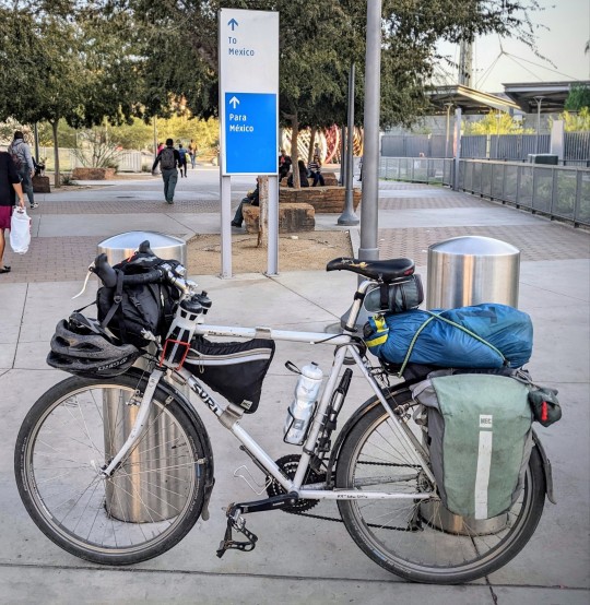
I didn't have any mechanical issues. Other than my saddle falling apart (which it was before the trip) the bike is still in great shape. I'll likely be getting some new panniers if I do another trip, maybe slightly larger ones. The handlebar bag I got new this year worked great and I was happy to have it.
My body held up OK for the most part. I had a scare on the very first day when the back of my right knee started to hurt. I had something similar happen a couple years ago on a short overnight bike trip to Vancouver Island, and it took a few weeks to heal. I think I may have just been a bit dehydrated, though, as the next day it felt better and didn't act up again. My hamstrings were pretty tight each morning for the first maybe four weeks. They'd be sore as I started to cycle, then after about 15 minutes they'd be warmed up and felt fine. I'm not sure exactly where, but that tightness did go away entirely sometime after San Francisco. I also tweaked my neck early on, and that was pretty rough at times. Off the bike it was mostly fine but on the bike it would get very stiff after about 30mins, and I had difficulty turning my head to the left. If I got off the back, the tightness would go away (though I would get a pain occasionally off the bike, too). That also has seemed to mostly clear up. I'd still get a bit of tightness while riding towards the end, but it felt very minor.
And most importantly, the best ice cream I had was a marionberry-lemon cone at a place in San Luis Obispo and Tillamook's Mudslide flavour.
As much as I've enjoyed the trip, I'm also glad to be done. I tend to feel that whenever I travel and I'm near the end. There is a comforting feeling for me getting back to my own place, bed, bathroom, kitchen that can't be found when on the go. I'm sure that won't last too long, though, and I'll be looking for the next adventure before long!

0 notes
Text

Nerd alert!
Before the trip started, I had budgeted between five and six weeks to cycle to San Diego, and I thought I'd average about 100km a day.
Timewise I was right on track. 40 days from start to finish, including four days where I didn't cycle. Distance wise I was at roughly 84kms per day when I cycled, so a little less than anticipated but not far off in retrospect.
I had Strava running for pretty much all of my cycling. I missed a couple short sections that I didn't fill out manual activities for and did a little bit of riding some days after hitting my stopping point for the day that I didn't record. From Strava, I've got the following:
Total distance - 3036km
Average distance/day - 84km
Total elevation gain - 28783m (roughly three and a quarter Mt Everests)
Average elevation gain/day - 799.5m
Total time cycling - 161hrs
Average time cycling/day - 4hr 28m
Average speed - 19km/hr
0 notes
Text

Week 6 - Cachuma Lake Campground to Mexico/US Border (San Diego)
Oct 23-27
0 notes
Text

Day 40 - San Clemente to San Diego and the Mexico/US border
And that's a wrap. 40 days from Vancouver to San Diego.
I got an early start today, on the road by about 7:20am. I stopped at a Mexican place for a breakfast burrito then it was down to riding. I wanted to get to the border and not just San Diego, so I knew it would be a big day.
First up was riding past Camp Pendleton - a US military base. You can't ride on the roads through the base other than the interstate unless you get a pass. But the pass is only available at the southern end of the base and possibly challenging to get if you aren't a US citizen. So that was out of the question. Riding on the I5 it is. Despite being a four lane freeway, the riding itself was fine. Noisy, but fine. I was on it for maybe a 12km stretch leading into Oceanside.
From Oceanside, it was mostly riding on the Pacific Coast Highway, which at that point was either Hwy 1 or 101 or both. It takes you through a number of beach towns. It's hard to remember them all at this point. Not just today, but from the entire trip.
I did notice an increase in cyclists through places such as Carlsbad and Encinitas. Must be popular with the locals. Also lots of great little cafes and whatnot to stop at along that stretch.
The last big climb of the trip came through Torrey Pines State Reserve, also where the Torrey Pines golf club is. I had stopped for a bio break a bit earlier and a local guy had told me to check out the glider club at the top of the hill, a short detour from the main road. The glider club is where paragliders launch themselves from. When I was there a class was going on so mostly just people learning how to get their parachute stable while on the ground - like flying a kite a bit. You can buy a tandem ride and I did see someone take off. Was neat to watch.
Down from the hill was La Jolla - a ritzy little town with a nice waterfront. I hung out at the water for a short while before heading onwards to downtown San Diego where I caught a ferry over to Coronado.
I was pretty gassed by the time I got to the ferry, but I knew I still had about an hour and a half left of cycling and wanted to get back to downtown San Diego before it got too dark. So I pushed onwards through Coronado to finally reach San Ysidro - the border crossing into Mexico. I grabbed a couple pics, got a celebratory McFlurry, and took the trolley back to downtown San Diego where i then cycled the final 5km in the last bits of daylight to my hostel in Ocean Beach for the next few nights.


0 notes
Text

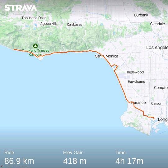
Day 39 - Wilmington to San Clemente
Was an interesting ride out of Wilmington this morning. I was staying in a fairly industrial area, so was riding alongside lots of big rigs for a few KMs before I got to Long Beach where it turned more middle-class residential. Then dedicated bike lanes took me through downtown Long Beach before entering more residential areas that quickly turned to very affluent residential streets. It was really nice biking through that stretch in Long Beach. Kind of allows you to get a feel for what it would be like living there - or sense of how it all connects.
I was then on Hwy 1 for a short spell before getting onto another long stretch of bike paths next to a series of beaches - much like yesterday. I think close to 20kms worth. Sunset Beach, Bolsa Chica Beach, Huntington Beach, Newport Beach, and Balboa Beach. Huntington Beach onwards was particularly nice - lots of residential areas mixed with cafes, restaurants, and other commercial buildings. Could have spent quite a bit of time checking it all out.
I had heard Balboa Island was something worth checking out. Turns out from Balboa Beach you can catch a short ferry ride to the island, which then connects back to Hwy 1. So that's what I ended up doing. Balboa Beach itself has a small 'fun zone' for kids. Rides, arcades, that sort of thing. Balboa Island is mostly residential, or maybe vacation homes. Was fun to bike along the streets and check out the area.
Shortly I stopped for lunch at a deli, then onto Laguna Beach. Unlike other areas nearby, the terrain turned a bit hilly and offered some nice views of the coast from higher up. They also seem to take really good care of their parks which are lush with vegetation.
It's also remarkable how much of the last few days I've been able to cycle on dedicated bike paths or at least on roadways with bike lanes. It all connects fairly well to allow cyclists to make it down the coast.
I did make a short side trip in San Juan Capistrano to check out the mission up there. It's a small town, but has a quaint centre and one of the more famous missions in California. I didn't go in, didn't want to leave my bike locked up and the day was growing long, but still glad I made the trek inland.
Destination tonight is hostel/motel type deal in San Clemente. Tomorrow will be a longer day. I'm not sure if I'll cycle all the way to the border or just stop in San Diego, I'll see how I'm feeling, but either way tomorrow I'll be at my final city!


0 notes
Text

#Lifegoals
To have so much money that you buy a massive plot of landing in a crazy expensive place and build a huge home that MINIMIZES floor space.
0 notes
Text
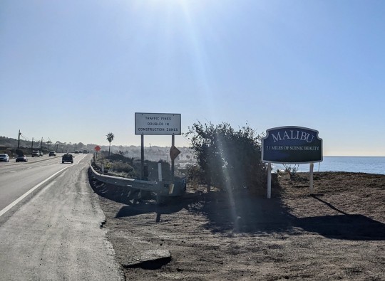
Day 38 - Leo Carrillo State Park Campground to Wilmington
Last night was the final camping night of the trip. Options were limited south, so I found a cheap motel and hostel tonight and tomorrow night. Thankfully last night was bone dry, so all my camping equipment can stay packed away until I get back to Vancouver.
Last night was also the warmest night on the trip. Was nice getting out of the tent in the morning and not feeling a chill.
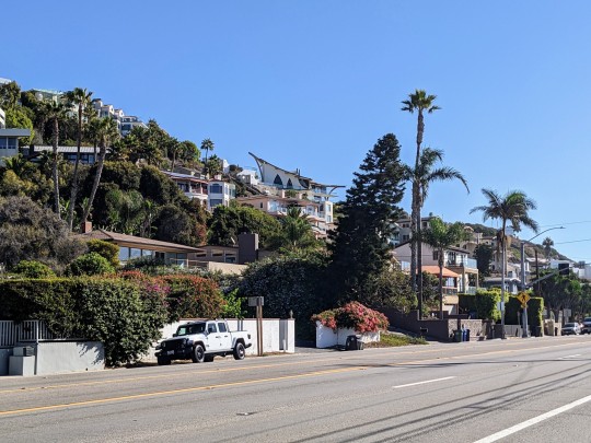
The riding today started through Malibu. Given how well known it is, I thought there might be more to it. It's mostly just big homes up in the hills and on the ocean side of Hwy 1. There wasn't any real city centre or anything. I guess just homes for the rich who don't need amenities (they have everything in their homes?).
Cycling along Hwy 1 went fine. I'd read it can feel sketchy at times with lots of cars parked on the shoulder forcing you onto the highway. There were certainly a number of times that happened, but I'd just wait a couple seconds for a lull in traffic and pass the parked cars. Went pretty smooth and after about 30kms I hit Santa Monica and the start of a 20 mile bike path along the stretch of beaches through LA and the surrounding cities. The bike path wasn't too busy, thankfully, as I can imagine on a weekend or during prime time the area would be swarming with people. The stretch of beaches is pretty astonishing. I was surprised by the size and how clean and well maintained it was. It was nice to see that they take so much care of such a huge area.
I didn't stop too much to hang out, the riding was going pretty smooth and I was enjoying just going along the path through all the different beaches (Santa Monica, Venice, Manhattan, Hermosa, Redondo, and more).
After some time, I needed to start heading east through the city. Google Maps had me cut over through Torrence to get to Wilmington, my destination for the night. That ended up being mostly on bike lanes on the city streets, though LA seems to have a penchant for creating bike lanes that just…end. To be fair this is a common thing I find in lots of cities. Weird planning 🤔. Usually at that point I try to find a side street to ride on before coming across more bike lanes. That worked out well enough for me.
My motel for the night is near LA's cruise ship port. There isn't much around so I will just stay in tonight after grabbing dinner. The port is far enough away for me to not want to check out.
Hitting the home stretch now, two more days of riding and I'm in San Diego!


0 notes
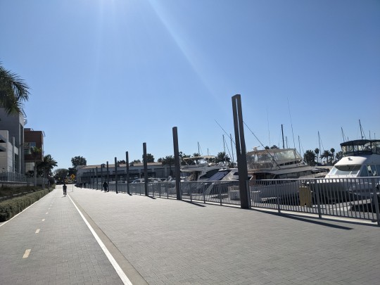
Text
Beautiful bike paths!
I've had some really beautiful bike paths along the coast. I'm thinking many have been installed (such as the one above) for safety reasons, keeping cyclists off freeways when possible due to how many people cycle along the coast.
0 notes
Text

Day 37 - Carpinteria State Beach to Leo Carrillo State Park Campground
Today got off to a great start. Once the sun rose the morning chill lifted and warmed right up. I made my way to the beach at the campground and saw a bunch of dolphins just off shore. It was fun watching them for a few minutes. I'm assuming they were feeding, but I like to think they were playing - racing around and jumping clear out of the water.
The campground itself wasn't anything special, but I really liked it. The location is perfect - right in the town itself and on the beach. They also do a good job of making it feel very secure. I did a quick tour of the town centre after leaving camp, grabbing some breakfast at a small Mexican deli.
There was a bike path shortly after leaving Carpinteria that kept my on the ocean side of the freeway and was really nice to bike along. It lasted for a good while before leading into Rincon Parkway which has RV camping spots lining the ocean side. Nice idea and a great place to camp out for RV owners.
Ventura was next. I did quickly ventura into the downtown. It was pretty quiet with streets closed to vehicle traffic. I was there just before 11am and most of the shops looked to be still closed. I didn't stay long, and the ride after Venture through Oxnard before rejoining Hwy 1 was fairly unremarkable (except for a nasty headwind).
The Pacific Coast route through Oxnard keeps you away from the city centre, but also offshore a little bit, so wasn't too exciting. There is a military base just before rejoining Hwy 1 that had a display of aircrafts by the roadside. Kind of interesting.
From there Hwy 1 took me to Leo Carrillo along the water. I think at this point I don't appreciate the ocean views quite the same, though in retrospect it is a pretty scenic roadway. Pretty flat too which helps the kms fly by.
Tomorrow I'll be riding through LA. I'll be sticking to the coast/beach paths and not going into the city. I figure I'll come back another time to try to do it justice. It's just too big and too much to see, and with the bike not ideal. I'm looking forward to riding along the beaches though! Should be good people-watching.


0 notes
Text

Day 36 - Cachuma Lake Campground to Carpinteria State Beach
I wasn't a big fan of the campground last night. The hiker/biker site had no level ground with tons of holes in the dirt presumably dug by animals. A number of downed tree branches left me wondering when the last time anyone did any sort of maintenance on the site. No food lockers either meaning I had to hang my food from a tree in hopes raccoons or other critters wouldn't get at it. But all good in the morning, and I got cycling shortly before 9am.
I was biking along Hwy 156 which I wouldn't recommend. The scenery itself was nice, but the road is very busy with fast moving traffic and the shoulder is next to nothing for maybe a 15km stretch near the lake. I'd say the least comfortable stretch of road for me.
The big redeeming factor was Stagecoach Rd which was the original throughway connecting Santa Barbara to Santa Ynez. It's since been replaced by Hwy 156, but remains in use for very little local traffic. It was basically deserted while I rode it, and was the route that I did today's big climb on.
San Marco Pass at 2225ft has replaced Leggitt Hill as the highest point on my trip. The climb itself went fine, was nice to be cycling on such a quiet road. The downhill too was a ton of fun on North San Marco Rd. Lots of tight switchbacks, and a popular hill for local cyclists. As I was screaming down I passed maybe a dozen or so cyclists climbing the hill. I definitely looked out of place with my attire and loaded bike.
I then made my way into Santa Barbara. Previously when I thought of California it was beaches, bald mountains, tall palm trees, white buildings with red tile roofs, large boulevards, surfers, etc. Santa Barbara fits this to a tee. Really a beautiful city. I spent a couple hours touring around and grabbing some food before moving on. I could have easily spent a bunch more time checking it out.
Carpinteria is the destination tonight, the second last campground on my route that has hiker/biker sites. Clear skies and warm weather today continued into the evening for a beautiful sunset.


0 notes
Text

Week 5 - Carmel to Cachuma Lake Campground
Oct 16-22
With only 5 days of cycling and three really short rides, it will be the shortest week of the trip kilometer-wise.
0 notes
Text

Is that a zebra?
I've seen a decent amount of wildlife on the trip. Not tons and tons, but a good variety.
A few days ago I was biking around San Simeon. There were hills to my left at a distance, and I noticed some horses at the top. One was white with black stripes (or black with white stripes?). I did a double-take. A zebra?
A bit further down the road, and at the bottom of the hill closer to the road, a herd of zebra were walking along. It was definitely a strange site. I stopped to take a few pictures from across the highway, and I think some other cars saw me taking photos then noticed them as well, causing a bunch to pull over.
Later that day I say what I think we're dolphins just off shore. Just a few dorsal fins bobbing in and out of the water as they swam along. I didn't get any photos of that, but cool to see.
I've also spotted elk, deer, emus (today - at an emu/ostrich farm so not sure that counts 🤔), lizards, whales (again, at a fair distance), a large assortment of birds, sea lions and sea otters, and likely a bunch more I can't remember. Even some dinosaurs!


0 notes
Text

Day 35 - Lompoc to Cachuma Lake Campground
Short day today due to my last minute change of plan and no long needing to backtrack and take the more indirect route. The bike ride out of Lompoc heading east was fairly unremarkable, and I made good time to Solvang - I town I've heard about and was curious to see.
I'm not sure the history, but Solvang's town centre is decked out with tradition Danish buildings and accompanying stores and restaurants. A pretty unique place in California, and definitely draws a lot of tourists on a Saturday morning.
I got there around 11am, found a place for brunch, and then biked around a bit taking my time and hanging out. I'm not sure if I like the city or not - feels a bit made up for tourists sake, and was very busy, but does have its charm.
The road was busier than I expected too, likely because it is the weekend and it is also wine country so attracts a lot of people from the LA area. In any event, I saw Solvang, and now I know what it is about.
I didn't have long from Solvang to get the campground for the night. It's probably the biggest campground I've stayed at on this trip. Has its own restaurant, gas station, and store. It's situated on Cachuma Lake, and you can get a sense of the effects of drought in the area. The nearby dam is totally exposed, no water is even hitting it. Hopefully climate patterns change in this area over the coming years and rain returns in quantity - they certainly need it.
Grabbed a burger from the restaurant in camp for dinner tonight - didn't feel like cooking and it is very windy so my little stove would struggle a bit. The Yankees v Astros playoff game was on TV and, as a Jays fan, I was just wondering if there was anyway both teams could lose 🤔
Tomorrow will be another shorter day. That was planned unlike today so I can spend a bit of time in Santa Barbara. I do have a pretty big climb tomorrow morning - possibly the biggest of the trip, but then it'll be a fun downhill to the city and I think the rest of the ride to San Diego will be flat.


0 notes
Text

Day 34 - San Luis Obispo to Lompoc
Was good to get back cycling today. The two rests days were nice, but happy to be moving on again and getting closer to San Diego.
I've read online lots of people recommending ending in San Luis Obispo because riding further south just isn't that exciting. Busy with traffic and just people in general, and the coastal views aren't as amazing as they are further north.
I sort of felt that today. The ride leaving SLO was fine, just not very interesting. After getting out of the city I passed through a few small beach towns. They looked nice, but having cycled by so many already I haven't been super interested in slowing down to check them out.
Then it was back into farmland. A long stretch today reminded me very much of the ride between Santa Cruz and Monterey. The town of Guadalupe was somewhat interesting, if only for the fact it seemed like it was dominated by Spanish speakers. I have a hunch it is where a lot of the folks who end up working on the produce farmers live, and that appears to be mexican immigrants primarily.
Before the town of Orcutt, I spotted a couple fighter planes in the sky (F18s or something). The road had gotten close to the Vanderburgh Space Force base. I also spotted another bike tourer on the road ahead. Turns out it was Stephen, who I met at Kirk Creek campground a few nights ago. He lives in LA and doing a week long tour between Monterey and Santa Barbara. We cycled together into Orcutt to grab some lunch, then the rest of the way into Lompoc. He gave me his contact info in case I run into any problems in LA which was generous of him.
Tomorrow I was planning on riding in Solvang, then backtracking a few KMs to the 101 and turning south to the coast to camp. Riding Hwy 1 and 101 today wasn't great riding. Just lots of traffic and noisy. I enjoyed the ride much more when we left them for a winding, climbing backroad into Lompoc. I didn't think there was a hiker/biker campsite east of Solvang, but apparently after researching a bit more a phone call to confirm, there is. So tomorrow I'll stay a bit inland and cycle east past Solvang to camp, then the following day a big climb up and over a pass and down into Santa Barbara. That actually cuts out some distance for me, too. Tomorrow will likely be a shorter one giving me time to explore Solvang.


1 note
·
View note
Text

Day 33 - Rest Day (San Luis Obispo (SLO))
Another day off the bike. Took the morning to make a number of bookings to really nail down the last stretch. Flight back to Vancouver on Oct 31, and mapped out my last stays - a few campgrounds and a few motels/hostels as camping is not really available in and around the LA area.
With that said, just seven days of cycling left and I'll hit San Diego. I'm planning to have three full days there as I'll have to pack up my bike and gear, and would like time to see the town.
SLO has a farmer's market on Thursday evenings. A bit strange to have a farmer's market in the evening, but it actually is a bit more than that. They have stalls setup on a street downtown for about a block or two devoted to produce, then they have a few more blocks of handmade, vintage clothing, baked goods, and then restaurant stalls. They also have live music at a number of the intersections. Really a good time, and impressive they pull it off each week. Lots of people checking it out, and it seemed like lots of locals which sort of adds from the charm of it.
I grabbed corn, ribs, churros, strawberries, and a small pumpkin bread loaf before heading back to the motel to pack up my stuff. Quite the haul but I had to try a few things. Hopefully my legs remember how to ride tomorrow after the two days off!


1 note
·
View note
Text
Day 32 - Rest Day (San Luis Obispo)
Quiet day for me today. Went out in the morning to grab a few groceries and took my clothes to a laundromat. I walked downtown last night and will head back down there tonight for some dinner and checking it out more.
Nice little town - not a ton to it, but friendly for cyclists with bike lanes everywhere. It is a bit of a college town so there are lots of cafes, breweries/bars, and the like.
Spent a fair bit of time in the afternoon trying to find the hole in my air mattress. I think I found it! Will give it time to dry then patch it up. I'll likely only have three more camping nights left and the rest will be indoors. The mass that is LA doesn't have camping options on the coast, they sort of end for me just before Malibu. I'll wrap up my planning for the last leg of the trip tomorrow, but will probably be 7 days of riding and I'll skip sightseeing in Los Angeles. It's a bit hard with a bike to do some of that stuff as I don't always feel comfortable leaving my bike locked up during the day while I go off somewhere - particularly in large cities with lots of characters.


0 notes
Text

Get lost
Navigating down the coast has been pretty easy so far. Most of the ride has been along either Hwy 101 through Washington, Oregon, and Northern California, and then Hwy 1 when it started at Leggitt, California.
With that said, there are a decent number of detours and side roads available, and I take them when I can. Google maps has been a big help, but you'll also see signs through Oregon and California denoting Pacific Coast bike route, and they will often be present at the turn offs for the side roads/detours. I'm not entirely sure, but I think they direct you to the recommended route the ACA (Adventure cycling association) has outlined. That organization has a number of bike routes mapped out across the US for bike tours, and you can buy the maps (physical or digital) which will show you the route, elevation changes, recommended campgrounds and resources like stores and water sources along the route.
I still make wrong turns here and there, mostly in towns and cities where navigating isn't as straightforward. This happened somewhat leading into and through San Fransisco, but also in small towns like Morro Bay where there can be bike paths but they don't also lead to anywhere useful.
Recently I've seen these arrow markers on the ground. I'm not 100% sure if they are also marking the Pacific Coast route, or they were placed there for charity rides. There was one going through Big Sur at the same time as me. The Challenged Athletes Foundation (CAF). They are pushing big days, averaging 110 miles a day, but are fully supported meaning the cyclists are just biking, and their belongings are shuttles around in a van, likely have a mechanic and possibly cooks travelling with them too. In any event, these markers gave so proven fairly useful for me as they have never put me on the wrong path.

0 notes