letourdecementa
Le Tour de Cementa
"When I see an adult on a bicycle, I do not despair for the future of the human race." H. G. Wells
11 posts
Don't wanna be here? Send us removal request.
Last Seen Blogs

doteuamigosecreto
Do Teu Amigo Secreto

undeadyoshi001
MIZUKO

tanya-ch
My name...?

frasesenespa-ol
Frases en español

villainii
♦ Ines ♦ Multifandom ♦ GFX ♦ Queued ♦
Text
Final leg: Le Tour de Cementa and a post-race analysis
The final leg was a cycle from Vale of Clwydd to Kandos. On this I trekked a distance of 95.2 km over which I ascended 1 302 m and had a moving time of 4 hours 39 minutes and 30 seconds, that provides an average speed of 20.5 km/h. The beginning of this day was emotional; I was happy that I'd soon be completing the tour but I also felt a sad to be ending the experience... these emotions were perhaps increased from my tiredness.
As I began my ride from Vale of Clwydd my mind and body knew that I now was moving toward the finish line and thus attempted me to move faster in order to win. A dash to the line... however, I knew that I still had to cycle 90 km that day, so I had to constantly tame against what my thoughts wanted me to do. Yet, this 'mental boost' made the climbing of hills to seem a little easier than the other days - most noticeably toward Ilford. This was a day which turned out to be as much of a battle with my mind as with my body.
Nice to see these around
Last post I mentioned the how beautiful it was to be in the landscape without distraction, to be truly in it. This was especially true on this ride as the distances between towns dramatically increased from the previous two days and the surrounding landscape widened to reveal a seemingly endless land in all directions. During those moments when cycling time and distance become almost absent. Sometimes you begin to feel lost and alone. This sense of isolation was heightened by the fact that cars and trucks passed less frequently than on previous days rides. On the journey I began to questions myself often: am I going in the right direction? What am I doing? Why am I doing this? How long until the next town? When is this hill going to stop?
It was tempting to bring out my phone to see exactly what the time was, where I was and what was next... however, checking these things on your phone isn't too helpful (especially when Google maps informs you that you're at the place you want to be, but in actual fact you are about 1 km downhill from it, which in turn makes it hard to trust technology which was my main connection to 'civilised life'). Moreover, as I didn't know the road I never knew what lay ahead. At times I felt very alone and alienated from society as I had increasingly less contact with people. This isolation from people led to many conversations with myself. And I think it's quite important to have and maintain a good sense of humour when travelling like this (I guess any sort of travel is more enjoyable through good humour). You also turn a little incoherent, I think.
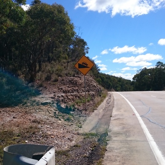
Looking at road signs was a particular fascination that developed over the journey and kept my mind occupied. The token bike sign was placed every couple of kilometers along the highway - funnily, it kind of resembles the animal signs you also see with kangaroos, koalas and wombats.

Well positioned signs
As I came toward the end of my journey - I could tell as the distance signs now included Kandos - I began to think of what will happen when I arrive and what will the reception be like on the finish line... it's important not to carry high expectation, you may be a little disheartened. But that doesn't dimish the sense of achievement.
Overall, it was a pretty tough race and I'm impressed with my result of first place - I'm looking forward to be written down in the record books!
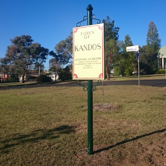
Finally... made it!
I'd like to thank all those who supported me on Le Tour de Cementa in particular to Alex Wisser for organising and Ian Millis and Julie Williams whom provided accommodation, food and good conversation. Every little bit of effort couldn't have been done without your help.
The Tour Stats:
Length: 245.7km
Total moving time:13 hours 30 minutes 15 seconds
Highest peak: 1 086 m
Highest climb gradiant: 30.1 %
Fastest speed: 63.7 km
Longest day: 95.2 km
Muesli bars consumed: about 20
Below you can see the breakdown of each day with a map.
0 notes
Photo
It's been an enjoyable day for riding: negligible wind and clear blue skies with some great scenery and not too steep climbs. After 3 hours 13 minutes 44 seconds (I think that's how long it takes to drive from Sydney to Kandos?) of cycling covering a distance of 64.7 km I'm now having a much required pit stop for a refuel. After I'm in for a brief climb and then a long descent into Kandos. #cementa #cycling #sydtokandos (at Running Stream, New South Wales, Australia)
0 notes
Photo
The final day of Le Tour de Cementa. #cementa #cycling #sydtokandos (at Vale of Clwydd)
0 notes
Text
Overview of Day 2: Linden to Vale of Clwydd
Day two of Le Tour de Cementa had me cycle from Linden to the Vale of Clwydd (distance: 61.7 km and elevation: 1 552m). After a night where I heard the wind howling as I went to sleep, then woke in the morning to see the trees swaying and hear the howling wind I was not looking forward to cycling... however, with grit and commitment I pushed on.
During the first segment to Katoomba I felt the lactic acid in my legs; remnants from the previous days ride. It’s a strange feeling, kind of like burning or stinging which you can feel each individual tendon/muscle/ligament in a section of the body (this case the upper legs) strained. It’s painful. But oddly kind of pleasurable, a reminder that I was alive and my body was present. It was a strong reminder to stretch after riding, perhaps, however, it tells me I’m a little bit masochist - surely one has to be to do this kind of thing right?
Encouragement was found in my ride as the landscape of the Blue Mountains began to reveal itself. At first it was the occasional glimpse through the trees bordering the road as they began to thin out at peaks and when along the raised bridge sections of the road. I could see the jaggered cliffs piercing the dense spread of trees. Furthermore, as I began to see larger townships I found their landscapes to be engaging. As domesticated gardens introduced interruptions to the standard grey/green of the natural bushland through dashes of red and orange and the structures of buildings created breaks from the organic swirls of the twisting gum trees to geometric slabs slotted together.
It’s true you can see the same thing in a car, bus or train, but on a bicycle the experience of the landscape is slower and, I’d argue, more thoroughly engaging - it’s like an ‘augmented’ or ‘virtual reality’ of mechanical transport. Your body becomes part of the landscape. You’re completely immersed within it, physically and mentally. You battle against ascents, the wind, temperature or rain, you smell the fragrances, eucalypt and floral, you hear the birds, the trees and the ground as your tyres tread. This was felt noticeably in two sections I rode today.

Perfect for bicycles right?
The first was along the shared trail between Medlow Bath and Blackheath. This stretch was an unsealed trail running parallel to the highway, but removed by trees and at times land and the train line so noise was minimal to none. The only sounds I heard were my tyres spinning across the ground, the wind in the trees and the occasional bird call. The sights I could see were magnificent: trees closely bordering the trail and at times creating archways and views of the mountain ranges as the trail followed the edge close to a steep descent.
youtube
On the trail
The second was from Mount Victoria to Vale of Clwydd via Hartley Vale. This was a back route, off the highway and was thus relatively quiet, traffic wise. A particular moment of this section was the climb at the end. After shooting down a steep section swerving along the side of a valley and then riding through what can be described as an idyllic valley, with the movng clouds shifting light of late afternoon, sweeping pastures broken up by pockets of bush and surrounded by massive rocky escarpments, I was then set to climb a steep hill. And I mean a really steep hill. This was at the end of the day and I hadn’t had a proper lunch (as I hardly had an appetite and was consuming muesli bars about every half hour) and the effect was felt on the climb. My energy was low and I struggled. I upped my museli bar intake to 1 every 5 minutes. I could only ride a couple of metres until I needed to stop and rest and catch my breath (bare in mind this is also the day after Old Bathurst Road, both are ‘category 3′ climbs). I eventually conquered the hill and was rapid in the descent. And the feeling of that descent was glorious. It led me right into Vale of Clwydd, in late afternoon the sun was shining on a dramatic angle leading to a fascinating display of the landscape and I felt entranced.

Warning sign...
But, at times these moments of bliss and serenity I had with the landscape today were disrupted by the noise, sight and sometimes smell of passing cars, trucks, buses and motorbikes. I felt disturbed at the times when I was passed by a truck or bus and saw the plumes of dark smoke bellow from the exhaust pipe. I had to breathe in that air and that air would be put into my blood stream and sent around my body. To my mind then, it was an intrusion on the landscape (and my body).
One last thing, as I said cycling along the road is slower and thus you become more engaged. This has resulted in me noticing the vast amount of rubbish on strewn along the edges of certain roads. On the final climb I came across a very interesting site of nappies.

Nappies on the side of a road
Today, I reached a top speed of 59.8 km/h... with an average of 16 km/h.
Tomorrow will be my final day of riding to Kandos for Cementa. I will post the route tomorrow morning, followed by some progress updates and then an overview of the days ride after I finish. After that I think a ‘post-mortem’ of the ride should be done and posted.
0 notes
Photo

Day 2 Stage 2 of Le Tour de Cementa. After stage 1 climb to Katoomba I had a break to recharge the legs and mind (after feeling the lactic acid in my legs on the climb I remembered why it's a good idea to stretch). It's time to set off again... Looking forward to the down hill section! #cementa #cycling #sydtokandos (at Katoomba Main Street)
0 notes
Photo

What's ahead on Le Tour de Cementa. Day 2 Stage 1: climb from Linden to Katoomba. Weather report: windy... Time to battle it out. #cementa #cycling #sydtokandos (at Linden NSW)
0 notes
Text
Overview of Day 1: Sydney to Linden
Today I kicked off the ride to Kandos just after 8am on my bicycle from my home in Leichhardt to Linden, the first overnight stop. The day was split into three stages. The first stage was Leichhardt to Parramatta. This section was mostly flat with the occasional small hill. The distance was 22.5 km and I completed it in a time of 1:19:32. The second section was from Parramatta to Emu Plains. This had a slight incline but was again mostly flat. The distance was 42.8km and I rode it in a time of 2 hours 44 minutes and 12 seconds. The third and final stage for the first day was Emu Plains to Linden. This had an insane climb up Old Bathurst Road - that took serious commitment and I’d suggest to take the highway route if you ever cycle around these parts, one section has an average gradient of 17%. And then a steady incline from the top of Old Bathurst Road to Linden. The total distance is 23.5 km and I rode this one in a time of 2 hours 10 minutes 5 seconds. All up my total moving time was 4 hours 59 minutes 41 seconds and in that time I rode 88.8 km and ascended 1 259 metres with an average of 17.8 km/h and a top speed of 46.4 km/h.

Part way up Old Bathurst Road
I had only a few brief battles against the elements today: a passing shower and some gusty head winds. When I left Parramatta I took a side trip to Greystanes aqueduct (a lovely path/cylceway I recommend travelling) and on the way to the M4 (the road I’d ride to Emu Plains on) I saw storm clouds looming in the west, toward Penrith, the direction of my travel. I was expecting some rain, but I wasn’t completely prepared (such a fool) - I only had a rain jacket and my bag is waterproof. Thus, as I rode I thought: I’d soon be riding on the M4 and the chances of quickly getting under shelter when caught in a downpour are slim so, I have two options, I could take a gamble and continue to ride and hope the rain dissipates and stops before it reaches me or I could stop and get under cover to wait until the rain passes ). I took the chance and continued to ride.
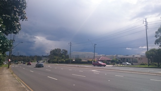
Rain clouds???
Seeing dark grey clouds in the sky is quite intimidating when riding on a bike (you feel very, very exposed). I hence needed reassurance that it wasn’t about to bucket down so I often checked the rain radar on my phone. Indeed, the rain was becoming sparse on the radar. I did catch some rain, and had to wait underneath a tunnel for a few minutes. Blue sky was now visible and with the rain stopped I continued to ride. But then the wind struck, a head wind.
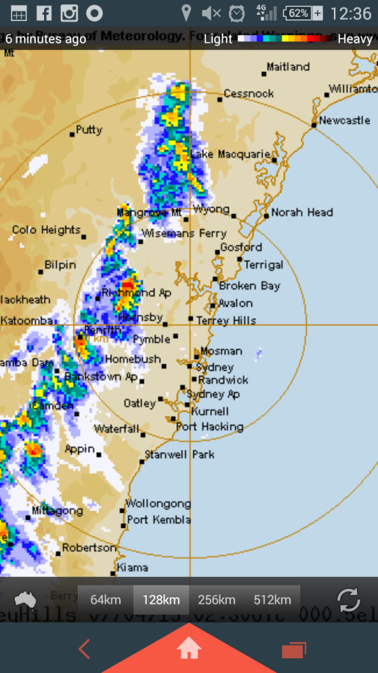
Rain radar! At this point in time I was between Homebush and Penrith in the patch with no rain.
The wind wasn’t constant which was nice, I rode through several isolated patches of strong wind between the Nepean River and Lindon. Some of the wind came from the side and swayed me with my bike a little, at least enough to have some sort of an effect on my ride. Most of the wind, however, was a head wind and at times it made pedaling almost impossible - I was almost halted by the wind at certain points given.

Stopped underneath bridge crossing M4 to wait for rain to pass.
Given all these challenges in the ride, one thing that was certainly needed (and tested) was determination and commitment. I could’ve stopped riding up Old Bathurst Road and rode the alternative route up the M4, I even had that thought run through my mind several times. But I didn’t, I kept going. And I will keep going until I reach Kandos.

Greystanes Aqueduct - reutilised into a path/cycleway
0 notes
Video
After brief rainfall... Repeated motions of pedalling. Cars and trucks whizzing by. @cementafestival here I come! Just passed Penrith, about to begin the climb. #cementa #cycling #sydtokandos (at M4)
0 notes
Photo

First pit stop of Le Tour DeCementa: Parramatta.... Coffee is essential for all bike rides, right? #cementa #cycling #sydtokandos (at Parramatta, New South Wales)
0 notes
Photo

So it begins. Le Tour DeCementa @cementafestival #cycling #cementa #sydtokandos (at Jarrett Street)
0 notes
Text
Preparation
Last night I watched Into the Wild for the first time. I did this for some preparation in the lead up to my bicycle ride to Kandos on Tuesday (primarily for good quotes to include in this blog). I did not know the entire narrative, all I knew was it was about travel and adventure and going ‘into the wild’. I will not spoil it for anyone who hasn’t yet seen it, but all I can say is that it ended with me feeling emotionally mixed. Indeed, all adventures have emotional swirls and physical effects which persist after the journey.
This cycling tour comes after just six weeks of completing my Sydney to Melbourne tour. On that tour I sustained an injury to my left knee, which held me back from cycling for about four weeks. I was quite disheartened to arrive in Melbourne unable to ride my bike without pain - I had been planning to experience Melbourne’s cycling network as comparison to Sydney’s. As such, I have only in the past week cycled around Sydney in preparation for my ride to Kandos next Tuesday.
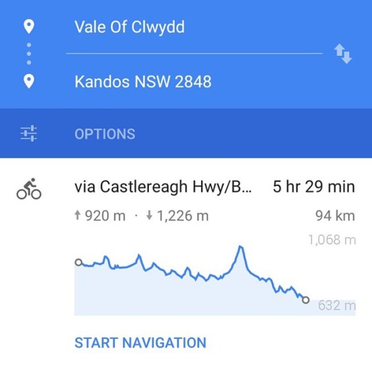
My ride from Sydney to Kandos will occur across three days, from 7 April 2015 til 9 April 2015. I will stay at two artists houses along the way. For the first day I will ride from my house in Leichhardt to Linden where I will stay overnight at Ian Milliss’s house. According to Google search on maps, this route is 77.6 km and will take 4 hours and 52 minutes. On the second day I will ride from Linden to the Vale of Clwydd and stay overnight at Julie Williams’s house. Again, Google maps this out and says it will be 58.6 km and 4 hours 18 minutes of riding... On the third day I will ride from the Vale of Clwydd to Kandos. Google informs me that this will be 93.6 km and take 5 hours and 29 minutes... I will, of course, be stopping along the way triple checking I’m heading in the correct direction and making/taking several detours to visit some places of interest - keeping my mind occupied and to encourage myself to continue to pedal. So, this information that Google maps out before me is taken with a grain of salt. (On a side note, my tour from Sydney to Melbourne ingrained in my mind a distrust of road signs telling the distance to the next town).
I have some technology I’ll put to use to record this tour: the Garmin VIRB Elite. This will record my journey in visual, via time lapse footage, and statistics, via GPS (map, speed,distance and elevation). I trialed the camera on a ride to La Perouse last Thursday. The footage can be seen below (note the speed reached at certain times when I’m stationary, this is a fault with the firmware in the device which I hope will be fixed soon).
youtube
0 notes