
Don't wanna be here? Send us removal request.
Statistics
We looked inside some of the posts by lpsupercellwxblog and here's what we found interesting.
Average Info
Notes Per Post
0
Likes Per Post
0
Reblog Per Post
0
Reply Per Post
0
Time Between Posts
2 months
Number of Posts By Type
Photo
2
Text
15
Last Seen Tumblr Blogs


Fun Fact
Tumblr posted its first advertisements in May 2012 and subsequently earned $13M in revenue.
Photo

@yourwxforecasts-blog @chasingthedream460 @pietruswx-blog @emilyrobertsonwx-blog @tommygthewx @jrileywx @wxbythemar @slaltrellowx @vmax140
Ray-Ban Sunglasses
0 notes
Photo

@yourwxforecasts-blog @chasingthedream460 @pietruswx-blog @emilyrobertsonwx-blog @tommygthewx @jrileywx @wxbythemar @slaltrellowx @vmax140
Ray-Ban Sunglasses
0 notes
Text
Severe Weather Threatens the SE Again
The tricky part of the Wednesday forecast is that many students will be driving back home for the Easter Holiday, and most of the state of MS will be impacted by some form of severe weather.
April 17th, 2019 (evening) and April 20th, 2019
Wednesday Thoughts
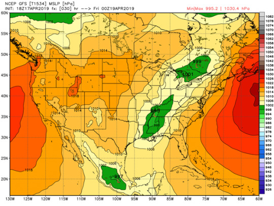
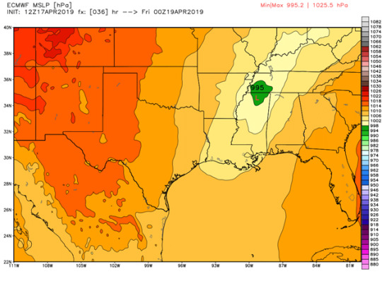
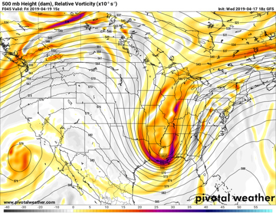
There is currently an upper level trough lifting out of the great plains region that brought severe weather to portions of Oklahoma and north Texas today. The NWS in Jackson put into works better than I ever could, the process behind the formation of the secondary low that will bring severe weather to the southeast tomorrow: “Lee side cyclogenesis will occur over the High Plains with the main low lifting northeast into the upper Midwest by tomorrow morning with an attendant cold front draped through the Mississippi River Valley. A perturbation propagating along the frontal boundary over east Texas will help induce a second area of cyclogenesis beneath favorable upper jet dynamics with a deepening low (~995mb) lifting through southern Arkansas into far northern Mississippi through the day tomorrow.” The surface low is expected to deepen as it moves northeast through north Mississippi. A deepening low moving this far south puts south Mississippi and southeast Louisiana in the prime region for dynamics that support a severe weather threat. The 500mb vorticity is very impressive with this low. Most of the upper levels look rather impressive, the only thing that could limit the setup in my opinion is on the mesoscale.
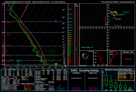
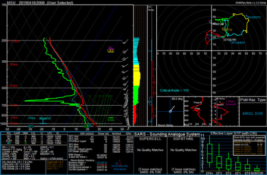
The CAM models are on board for significant severe weather tomorrow. The updraft helicity values on the 3km NAM show rotating updrafts through central to south Louisiana all the way though central Mississippi. CAPE values are not shocking, but they are sufficient enough for severe weather in the 1500J/kg – 2000J/kg range. The most favorable part of this set up is the shear. Surface winds are coming from the southeast, which means impressive turning in the low levels. The image below is a forecast sounding from the 3km NAM taken from southeast Louisiana showing quite the impressive hodograph (especially for southeast Louisiana). If there is no large MCS/prefrontal convection, we could see some supercell activity ahead of the line. My bets are on Hattiesburg for the likeliness of seeing the strongest storms.
A Look Back (Written on Saturday)
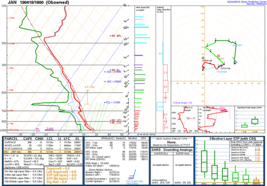
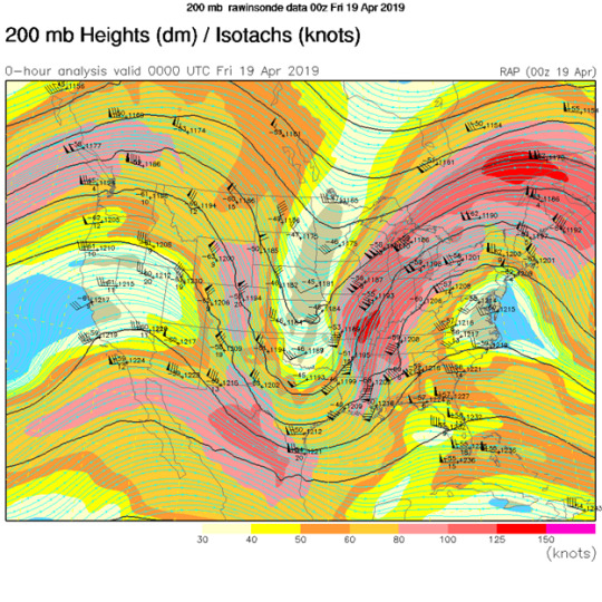
An impressive trough dug to the deep south on Thursday. As seen on a 200mb analysis map, 125kt winds were found over the state of Mississippi at 0z Friday, right as the line was passing through northeast Mississippi. The sounding below is from Starkville, MS at 21z on Thursday, right before the flash flooding occurred. Starkville is well above average for rainfall this year so far, so intense amounts of rain in a short time period was problematic. (Notice the veering and then backing winds).
Multiple tornadoes were reported in the central part of the state near Jackson, MS during the mid part of the day on Thursday. The tornadoes were embedded within a large QLCS tracking across the state. The sounding below is taken from Jackson at 18z Thursday, shortly before the tornadoes occurred. One interesting aspect of the sounding in the veering winds at the surface with backing winds about 100mb above that. This type of wind profile was seen on models days before this event and was even more evident further north in the Starkville soundings. I’m not sure what effect this wind profile had on the event, but I thought it was interesting to note – this could be something important for future tornadogensis research. There also was not much CAPE in the Jackson sounding, but the temperature and humidity profiles were similar to what is seen during large QLCS events.
As this trough began to lift out of the southeast, it continued to bring severe weather along the east coast. A moderate risk was issued for parts of Virginia and North Caroline, which does not happen often. The risk verified rather well, with a large number of damaging wind reports and extensive damage reports.
0 notes
Text
Super Bulldog Weekend… Super Storms Weekend
April 12th, 2019 (Friday mid-day)
Track of the Low
I am surprised by how different the global models are on the strength and timing of the low being so close to the event. A surface low pressure system is forming in eastern Texas and will push northeast over the weekend. The ECMWF has a 1000mb low in Texas on 18z Saturday and 995mb over Memphis by 6z Sunday. The GFS disagrees with what the ECMWF is showing (and lessens the threat). The GFS has a stronger low initially at 995mb in eastern Texas at 0z Sunday and the low decreasing in strength to 998mb while over Memphis on 12 Sunday. A deepening low vs a strengthening low and a 6-hour difference in timing is very surprising this close to the event. Once the surface low initializes Texas models will likely have a better and more consistent handle on the system.


Temperatures and Dew Points
We’ve finally entered full on SPRING! With that being said, the pollen is way too plentiful… but also the temperatures are more conducive for strong convection. Temperatures across the southeast tomorrow will not be a limiting factor for tomorrow’s severe weather threat. North Louisiana is expected to reach the low to mid 70s tomorrow. The warmest area tomorrow is northeast Mississippi (right around Starkville), with temperatures expected to reach the lower 80s. Dew points will be no issues either with so much Gulf moisture being pulled in by the strong low pressure system. North Louisiana is expecting dew points in the mid 70s, and dew points to the east expected to increase to similar values as the low tracks closer to the northeast. These dew points are temperatures will be supportive for strong storms tomorrow.

Severe Weather Parameters
Let’s talk shear. 0-3km shear is HIGH. A strong low-level jet will be bringing in fast winds close to the surface. In the Mississippi Delta, by 0z Sunday, 0-3km shear is nearing 50kts. Similar values can be found across much of north Mississippi. North Louisiana 0-6km shear vectors are more parallel, which means that linear mode would occur quickly after storms form. There is a discrepancy in this between models, but more are on board for more parallel shear vectors rather than perpendicular.
CAPE for this event is not forecast to be record-breaking, but this is not a high shear low CAPE event. Greatest CAPE values found on the most recent model output can be found in southcentral Louisiana. Values nearing 2700J/kg is what the models are showing by Saturday morning. 1500J/kg CAPE values shown across much of Mississippi. While models are showing decent CAPE, morning rain could be a limiting factor for this. How much rain occurs and where is occurs will significantly impact the threat later in the day into overnight.

0 notes
Text
Looking Ahead: An Active Pattern Coming for the Eastern United States
April 4th, 2019 (Tuesday mid-day)
General outlook of what is coming
It has been a beautiful past few days in northeast MS, with morning lows in the 30s-40s and afternoon highs in the 60s-70s with sunny skies. We can thank a strong weekend cold front followed by a ridge sitting over the eastern United States for that. Changes are coming though – by the end of this weekend, the active pattern will be returning to our area. Model consensus agrees that we have lots of rain and the potential for severe weather over the next week is in the picture. The WPC has a large part of MS, LA, AR, and AL (okay – yes, pretty much the whole SE US) seeing a significant about of rainfall over the next 7 days. Some areas are forecasted to see up to 5 inches of rain. On a college campus, there are so many events that happen outdoors on the weekends – so Starkville needs to pay close attention to the forecast this weekend.

Severe Weather Threat for Oklahoma and Texas today
A slight risk has been put into place for the northwest part of Texas and parts of western Oklahoma. The primary threat outlined by the SPC is the risk for large hail. I agree with the SPC on the much higher hail risk than tornado risk. While there is some turning, the surface winds do not look favorable for tornado development. Based on mid-day surface observations, the Texas portion of the slight risk region looks to be more favorable for storm development – thermodynamics (CAPE, instability) as well as dynamic variables (forcing, 700 UVVS). The thermodynamics will only improve in the northeast Texas region due to some clearing ahead of the storms, whereas Oklahoma is still sitting under clouds. Surface heating will also help to break the cap today and allow storms to quickly fire off.


Severe Weather Threat for the Southeast on Thursday
The slight risk outlined by the SPC has shifted further west today than it was yesterday and in the Day 4 and Day 5 outlook, to no surprise. The threat seems to decrease significantly as storms approach central Mississippi. The rain out ahead of the front will begin by lunchtime Thursday. Models are also showing a MCS along the Gulf Coast Thursday, which would greatly decrease the severe weather threat as it would cut off the low form the Gulf. The line of storms will reach central MS by Thursday evening and not much is expected besides gusty winds and some thunder. The area I think has the greatest severe/tornado potential based on different severe weather parameters is far northeast LA – will be watching this area tomorrow.

What About for the Weekend in Starkville?
The weekend will start out okay but looks to end in a very stormy fashion. If you’re planning on outdoor activities, I would make sure to schedule them for Friday or early on Saturday! We’ll be pushing close to 80 on Saturday – and with dewpoints in the 60s, you’ll feel the humidity for sure. Dew points will shoot up even higher on Saturday into the upper 70s. By Saturday afternoon/evening I suspect a few scattered showers to begin to pop up. Sunday will be filled with on and off rain for most of the day before a cold front moves though late Sunday night into Monday morning.
Severe Threat Late Next Week?
Models really start to disagree by late next week, really by early next week agreement is not very strong. If the ECMWF is right, the southeast is looking at a potential severe weather threat. While I am going to refrain from looking at the details this early in time – I did take a look at the MSLP, just to get an idea of the patterns. By Thursday afternoon, the ECMWF had a decent surface low pressure system tracking through northern AR and central MO. The GFS has a much weaker low-pressure system tracking further south much quicker. This is just something to keep an eye out on, but obviously not threat just yet. With model disagreement and an active spring time pattern, there are so many ways this can go.


0 notes
Text
The Week Ahead Across the Country
Weather has been relatively quiet these past two weeks after coming off and an active pattern (but I am thankful because we had perfect Symposium weather). Severe threats aren’t in the forecast as of now, but we could see the rain return by the end of the week.
March 23rd, 2019 (Tuesday morning)
Overview
The eastern portion of the United States is currently sitting under a large high-pressure system that is centered over the Upper Great Lakes portion of the United States. Over the next few days, the ridge will continue to build and expand over a greater portion of the eastern United States. By late in the week, likely late Thursday or Friday (based on model consensus) a trough will begin to swing through and bring back more active weather to the eastern portion of the United States. Severe weather will not be a significant threat with this system. The late week trough will just bring rainfall to the eastern portion of the country and some possible snowfall in the far northeast portion of the United States.
After the late week/early weekend system, high pressure will build back in. High pressure will build across the central United States and then propagate across to US towards the eastern portion of the United States. By the following weekend, another low-pressure system begins to build out west. While it is too far out to look into the details of the system, there is some model consistency on the formation of a system between the most recent runs of the GFS and ECMWF. Side note: There is also a low-pressure system that forms late next week in the Gulf of Mexico and strengthens as it tracks northeast, which is present on both the GFS and ECMWF.


Let’s Talk Baseball vs. LSU Thursday, Friday, and Saturday
Thursday looks to be the best baseball weather for this weekend, so if you can make it out to the New Dude, I would highly recommend it. Temperatures for the Thursday game range from the mid 60s to the lower 60s, making it perfect baseball weather with pants and a light jacket! Rain chances are not in the forecast at all on Thursday, as the ridge sitting over the southeast US will continue to keep us dry on Thursday. Multiple models are showing some cloud cover, but thankfully completely overcast skies are not in the forecast. Perfect night to take down the tigers!

Day two starter is 6-0, so my forecast for the Friday game is a win! Weather wise, it is looking like a close call. Chance for some scattered showers is present Friday evening, but showers are not expected to be too widespread. Temperatures for the game look perfect though. Highs for Friday in the mid 70s, which we will hit around the time the gates open for the game. Temperatures during the game range from about 70 to about 60 (depending on game time end). Cloudy skies overhead is not what we want, but model guidance is hinting at some clouds possible later in the day on Friday.

On Saturday whenever we are going for the series win at 2pm (or maybe even the sweep – I am confident in us) will be when the not so perfect baseball weather might be present. Later in the game is where issues might show up. A cold front will move through Saturday afternoon. The relative humidity map from the 0z Tuesday ECMWF shown below shows the position of the cold front right before game time on Tuesday. If model guidance is correct, the front will likely be moving through around game time. The GFS timing is a good bit later, which would be less rainfall early on in the day on Saturday and more occurring during the overnight hours. Moisture is more abundant on the GFS as well compared to the ECMWF. The weather for Saturday is something to closely watch, as game time might have to be moved up to avoid the rain.

0 notes
Text
Another Weekend Severe Weather Threat in the Southeast
March 9th, 2019 (Saturday Morning)
Overview
The Storm Prediction has been highlighting a threat for 5 days prior to today of severe weather in a large portion of the southeast United States. There have been a few changes in the SPC outlook over the past few days. The day three outlook included areas further east such as north AL and western MS. The day two outlook shifted east, where the greatest threat was outlined along the TN and AR border. The day one outlook shifted back west to include a portion of north AL again. The greatest threat highlighted by the SPC was the wind threat, as well as the tornado threat.

The Setup
A deepening surface low is progressing through central Kansas this morning and is expected to bring significant weather across the United States. The 00z ECMWF has the low remaining in the 990-991mb range, so not much deepening as the low tracks towards the Great Lakes Region. The 06z GFS depicts a similar scenario with almost no deepening as the low makes northeast progression. While the low is already in the 990 range, severe weather is possible, but if the low was to rapidly, or even gradually deepen, the tornado and severe weather threat would be much higher than it is expected to be today.
Overall, the set up does not overly impressive. While dew points are in the mid-60s and temperatures in the mid to upper 70s in the warm sector, there is still limited instability. Temperatures have been very cool this week, and there has not been sufficient heating the past few days to help build the instability. CAPE is likely to top of near 1000J/kg, if it can get even reach those levels in the areas with the highest instability. There is a CAP seen in the morning soundings, which could provide stronger storms if it is able to break late in the day. There will be some daytime heating as clouds have started to show some breaks. Another limiting factor will be the winds. While southwest winds are not ideal, this does not mean there is no tornado threat – but the strong wind threat does seem to be higher.

CAM Guidance
If a secondary line of discrete cells forms further west, into far east MS and north AL then we could see some issues. The morning HRRR model runs show this happening, late this afternoon. While the winds aren’t supportive of discreet mode, it will be critical to watch how the winds shift throughout the day. The NAM is not nearly aggressive as the HRRR this morning. The NAM is showing a more linear evolution of the system today though the northeast MS region. The NAM does show some possible discreet development after sunset in far northeast MS, but with the extent of morning convection of the NAM, this scenario does not seem likely.


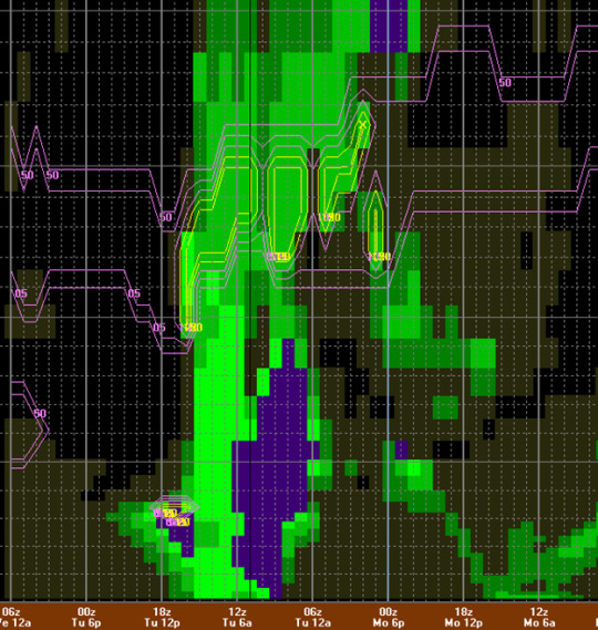
Starkville Tornado Threat
Around 5:30pm this evening, a discrete cell began to rotate to the southwest of Oktibbeha County. While the timing was off, the overall areas of convection was similar to what the HRRR was calling for, just two hours later. The cell moving towards Starkville began to rotate and the NWS Jackson issued a confirmed tornado warning on it. The odd thing with this storm is that it was moving slightly southeast, rather than northeast. Why was this storm moving this direction? Not sure – something I am going to look into tomorrow. The radar imagery of this storm was honestly hard to follow – a screenshot is posted below. I hope to go back and do some analysis on this and look at the different radar products. Another blog to come on this......

0 notes
Text
Mardi Gras Forecast for the Great City of New Orleans
The best time of the year is finally here! It is Mardi Gras season down in Southeast Louisiana and all we could ever ask for is sun and 75-degree weather. Unfortunately, the weather obviously never works out how we want it to. In this blog, I’ll dive into the forecast for all upcoming Carnival festivities!
February 27th, 2019 (Wednesday night-Thursday morning)
QPF
The image below shows the 5-day QPF totals across the US. Southeast Louisiana ranges from 1-2 inches of QPF over the holiday weekend, with the New Orleans are receiving the lower end of those totals and the Northshore on the upper end. The 12z Tuesday ECMWF, as well as the 18z Tuesday GFS, agree that the Northshore will likely see higher amounts of rainfall over the next five days. The major differences between the two models are the amount of QPF in south to central Mississippi, which is much greater on the GFS than on the ECMWF. As for the New Orleans metro area, both of these global models are showing around 1.3-1.4 inches of precipitation through 0z Tuesday.


When will all this precipitation occur? – Parade Forecast
The 12z Wednesday NAM shows a scattered rainfall on Thursday evening for the Northshore, as well as the city of New Orleans. The Krewe of Babylon, Chaos, and Muses, all of which roll Uptown on Thursday evening will likely see light rain, and a chance for delays if a heavy shower moves over the city. According to the NAM, scattered showers are shown for the Southshore Friday evening, which could cause even more delays for the French Quarter, Metairie, and Uptown parades that roll that evening. The Northshore is clear according to the NAM, allowing Orpheus and Selene to roll with no issues. I would be hesitant to stick with the NAM because global models are showing more scattered precipitation chances as moisture is pulled in from the Gulf Friday evening. The most recent run of the NAM loops through Saturday evening, showing some scattered activity, but nothing that would have a huge impact of the all-day festivities on Saturday.
The story changes Sunday when possible severe weather moves into the region. I’ll speak to the severe weather threat later, but as for the rain chances, they will significantly ramp up on Sunday. By mid-day Sunday, most of the Northshore will likely already be seeing rain. By evening, the Southshore will likely see rather steady moderate precipitation. By Monday morning, the rain will push out and clear skies will finally appear! More scattered showers are possible Mardi Gras day, but it appears to be a pleasant day in the greatest city in America! Cooler temperatures will follow the passage of the rain on Monday. We’re looking at highs in the lower 50s on Monday and Tuesday compared to highs in the lower 70s on Saturday and upper 70s on Sunday.

Severe Weather possible Sunday (when I have to drive from SELA back to Starkville)
The ECMWF had been more on board for the severe weather threat than the GFS has been in the past few days. Tuesday night and Wednesday morning model trends have been favorable in the GFS, but the threat still has many negative aspects of it. The low will be tracking rather far south, through southern AR and through north MS, placing the greatest threat further south of Starkville, closer to SELA. The low is not forecasted to be strong when moving through southern Arkansas but looks so significantly strengthen as it moves through TN and the Carolinas. Recent trends have been strengthening the low earlier on, but I do not see it strengthening significantly enough to drastically increase the chances besides what are already present in southeast LA and south MS for severe weather on Sunday.


Severe Weather Parameters for Sunday
The CAPE values on the Wednesday 0z ECMWF are highest just north and along the I-59 corridor, reaching values close to 2000 J/kg. The winds do not look favorable for tornado development in SELA, but are much more favorable further north, closer to Starkville. The soundings below show this well- the first sounding is for SELA when CAPE profiles are best. The second sounding below is from the GTR region and shows great backing before the front approaches, but that is also before the greatest CAPE arrives. In north/central MS, it seems as the severe weather threat will be all about the timing of the instability.


0 notes
Text
Rain Forecast for the Next 10 Days in the Southeast
February 18th, 2019 (Monday afternoon)
Last night
The rain began Sunday evening for what will be over a week long of rain in the mid-south region. According to the ASOS station at KSTF in Starkville, there was almost constant rain for 12 hours yesterday. Most hours recorded a trace amount of rainfall, but that easily adds up, especially the ones that recorded more than a trace. Most areas of Starkville ended up with anywhere from half an inch to an inch of rainfall. With an already saturated ground and more rain to come, this amount could add to the flooding threat for the remainder of the week and into early next week. One of the images below shows the soil moisture in Starkville, showing just how saturated the ground was before the rain began yesterday.


Comparing the GFS and Euro
The ECMWF and GFS are both on board for excessive rainfall through the next week. The 12z Monday GFS as well as the 12z Monday ECMWF have the bullseye for the greatest amount of precipitation to be over the western Tennessee area. The biggest difference between the two models is that the ECMWF had a secondary bullseye over areas of north Alabama. The highest totals shown on the GFS were between 5 and 6 inches. The ECMWF has portions in northeast Mississippi receiving up to 7.5 inches. The Starkville QPF totals between now and next Monday (7-day time period) are 4.7 inches (ECMWF) and 4.5 inches (GFS). The ECMWF is more aggressive on QPF over the next week.


GFS and Euro Ensembles
The ECMWF ensembles are similar to the operational run, with two main areas of highest QPF. The highest amounts according to the ECMWF are in north Alabama and western Tennessee. The GFS has overall higher QPF, but really just points out north Alabama as the area with significantly higher amounts of QPF. The GFS has 7-8 inches in the north Alabama area over the next 10 days. The CMC ensemble mean shows two areas of increased QPF like the ECMWF does, in very similar areas.


Severe Weather Outlook for the Weekend (Writing Tuesday Evening)
Honestly, I am shocked at the agreement of the GFS and the ECMWF on Saturday/Sunday’s severe weather threat with it still being four-five days out. The operational run of these two models have the placement of the low in almost the same exact location in northeast Missouri by 0z Sunday. The only difference between these two models regarding the low is the strength which is only off by 2mb (990mb vs 988mb). The ECMWF ensembles are still scattered, but more are quicker on the timing rather than later, most members are concentrated in MO though. More of the GFS ensembles are close to the operational run, but there are more members that are further away from the operational run.
The real question with this set up will be if there is enough instability, especially further south. While moisture won’t be an issue, the lack of sunshine could lead to instability issues. The GFS is showing 1000 -1800 J/kg of CAPE, southeast surface winds, mid to upper 60 degree dew points. The ECMWF is showing similar CAPE values, south to southeast surface winds, and mid to upper degree dew points. One interesting thing I found with this set-up is the CIPS Analogs, which indicates possible severe weather.


0 notes
Text
Wet Week Ahead in the Southeast US
February 16th, 2019 (Saturday Evening)
Soggy weather is what we have to look forward to for the next week, or I guess I should say sleeping weather. There will be threats of severe weather and flooding threats this week though, so we have plenty to talk about today.
Overview of the Week
With a battle of the trough in the west and a ridge in the east, the middle ground of the Southeast US will see excessive rainfall. Below is the WPC 7 Day rainfall graphic, which has amounts up to 15+ inches of rainfall in Northeast Alabama. Here in Mississippi, we could see 5-10 inches of rain in the next week. Much higher amounts possible in some locations since thunderstorms will be possible more than one day this upcoming week. Front behind front behind front will be the main contributor to the high amounts of rainfall.

Sunday not Funday
The rain will begin tomorrow and shows no sign of coming to an end here in the state of Mississippi. Scattered showers are likely to pop up due to forcing along the warm front. The warm front is currently located in southern MS/southeast LA and will propagate northward throughout the day on Sunday. By the evening hours, the first of many cold fronts this week will push through the state of Mississippi and bring more precipitation ahead of it. CAM models are all showing scattered showers tomorrow. The Saturday evening runs of the HRRR along with the evening NAM runs agree on scattered precipitation chances for the northern half of the state during the morning hours. By evening models agree on steady rain along the cold front.


Monday and Tuesday
Monday will likely be the driest day of the week – and if you want to see some sun, probably the only chance you are going to have. Even a little bit of sunshine will not be much help to an already saturated ground from the previous week as well as the previous day. Flooding issues could become a major concern by the time the rain arrives Monday night. The 12z Saturday ECMWF run differs slightly compared to the 18z Saturday GFS, but both agree that stratiform precipitation will begin late Monday night/early Tuesday morning. The rain will continue until the front arrives on late Wednesday evening when thunderstorms will become likely across the state of Mississippi.

Wednesday Is Only Important Because of Baseball
The SPC does not have much to say about the severe threat on Wednesday just yet, with just a thunderstorm possibility on the day 3 outlook. Depending on how much instability can arise will depend on what the threat becomes. The ECMWF has a decent enough amount of CAPE and shear to support severe convection, but there are plenty of negatives including a weak low and a low tracking far south. Taking a look at GFS forecast soundings, the greatest threat for severe weather looks to be in southeast Louisiana and south Mississippi (especially the Hattiesburg area) on Wednesday mid-day. The winds are not ideal for severe weather with not much directional shear in the low levels, but there is decent CAPE. Later in the day, the threat shifts further north and west – near the Birmingham area the winds are more supportive of non-linear convection, but the instability is much lower than earlier in the day in south Mississippi. If we’re lucky, the frontal passage will allow for enough dry air to move in for a brief time period to get in the 4pm baseball game before more rain moves in at the end of the week.


End of the Week – QPF Totals
The ECMWF is more aggressive on precipitation for this upcoming week than the GFS, both of which are shown below. The ECMWF has a bullseye over Starkville with almost 7 inches of rain between now and 12z Friday, which is before another front pushes through on Saturday. The system that is forecasted to move through on Saturday will be one to keep an eye on. The ECMWF has a strengthening low moving through central Missouri, but the GFS is really showing that this system may have potential. The GFS has a strengthening low pushing through central Arkansas. This system will be something to watch in the coming days for severe weather, but also for more rainfall that will further impact the flooding risk.


0 notes
Text
IOP #3 of 10 will commence for the VORTEX-SE #meso1819 Field Campaign beginning 18z Tuesday – 18z Thursday
February 5th, 2018 (Tuesday Evening) – February 6th, 2018 (Wednesday Evening)
Severe weather will threaten parts of the northeast portion of the VOTREX-SE domain on Wednesday into Thursday morning. Balloons will be launched throughout the SE to capture a more in-depth profile of the atmospheric conditions contributing to the severe weather threat in the southeast. A more in-depth description of the project can be found here: https://www.nssl.noaa.gov/projects/vortexse/
SPC Overview
The Storm Prediction Center has upgraded portions of Western Oklahoma and NW Arkansas to a slight risk of severe weather on Wednesday evening. The greatest threat for severe weather will be overnight, which is common for this time of year, especially in the south. The SPC outlines the upper-level trough that will dig across the Rockies over the next two days before beginning to life across the plains/northern portion of the Southeast Wednesday. The SPC states that the main threats will be locally damaging wind gust of a brief tornado. The day two discussion also states that as the convection becomes linear along the cold front could bring some tornadoes within the line of storms as shear looks favorable for the event.


The Low
The track of the low is very similar on the 18z Thursday GFS to the 12z Thursday ECMWF. The GFS is every so slightly further north than the ECMWF, but both models have the low passing through northeast Arkansas by 12z Thursday morning. The models also agree very well on timing- the GFS again is, ever so slightly quicker, but the differences are minor. The big differences in these two models in regard to the low can be seen in the strength. The ECMWF has the low strengthening earlier in its lifecycle, before reaching central MO, and then the GFS has the low strengthening quicker than the ECMWF after it passes central MO and continues to track northeast. This track for a low is favorable for severe weather in the southeast, specifically in northeast MS, but many other factors are against favorable severe weather during this set up, including how weak the low is at the time of passage through northeast Arkansas.


Looking More in Depth at the Global Models
From now until the arrival of the front, the ECMWF and GFS both show southerly flow at the surface streaming in from the Gulf of Mexico all the way to Arkansas. The stream of moisture will allow for dew points to rise to high values, especially for early February. Low level flow from the south will also all for decent warm air advection to occur over the state of Arkansas. Looking higher up at the 500mb level, there is not significant forcing until much later on Wednesday night.


Wednesday Update with a Look at Mesoscale Models
The reason this event may end up being non-significant is due to the upper level convection, rather than surface based. Many soundings are showing the possibility for convection, but the convection being show is elevated, and not surface based. An LCL much closer to the surface would need to be present for a decent tornado risk, unlike what is shown in the NAM forecast sounding for 9z early Thursday morning across north-central Arkansas. The Wednesday 18x VORTEX-SE sounding from Fort Smith, AR shows that the LCL is much lower and the capping inversion may not be as large and as high as expected. This will be something to watch going into the evening hours.


Looking at surface-based CAPE values, the 18z Thursday NAM is in favor of northeast Arkansas as well and parts of east-central Oklahoma during the late night to early overnight hours (CAPE simulation at 6z Thursday below). CAPE values are not too high (some to do with time of day), but they are high enough to produce some strong to severe storms. Wind gust will certainly be a threat with this system in portions of northeast Arkansas and slightly further east before atmospheric conditions become much less favorable closer to the TN/MS area. Small hail could also be a threat with this event since there is a decent amount of CAPE. As the event unfolds the main area to watch for tornado development though will be along the warm front during early night hours.

0 notes
Text
IT’S HAPPENING
January 26th, 2018 – January 30th, 2019
I’ve been waiting all winter for this possibility and it is finally here, hence the title of this blog. Throughout this blog I am going to dive into my thoughts regarding this event as well as my own forecast for the event starting Saturday (1/26) until right before the event on Monday (1/28). I hope to learn from this and be able to see changes as the models begin to improve and once I can incorporate real-time data.
Saturday Thoughts
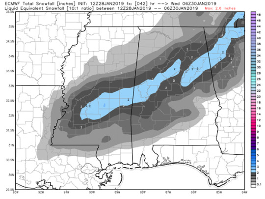
So, today some of the models decided to back off on the amount of precipitation that will fall over the course of this event (yes, ECMWF, I am looking at you). There is still consistency in northeast MS receiving enough snowfall to accumulate and cause issues. CAM data is just now becoming available, so I took a closer look at the Saturday 18z 12km NAM, and assuming that the model is correct, the snowfall could begin between 4am and 5am and come to an end around lunch time. The snow ratio looks to begin near 10:1 but end close to 15:1 as cold air continues to advect in as the snow falls. WPC snowfall probability maps can be found below, where an inch of snowfall or more was given a 70% chance of occurring and 2 inches or more of snowfall occurring was given a 50% chance in Starkville. A drastic shift happens with increased snowfall as parts of northeast MS are given between a 5-10% chance of 4 inches or greater occurring. There has been very little model support of greater than 4 inches occurring, most accumulations maps have shown between a trace and 3 inches of snowfall. Something else I’ve noticed on recent model runs – there seems to be a bullseye that appears in different places across northeast MS – this will be something to watch over the coming days.


Sunday Thoughts
Models trends have changed some today. The ECMWF has backed off significantly on the total precipitation amount as well as shifted the snowfall to central and southern Mississippi, rather than northeast MS. The 06z Sunday GFS aligns much better with the CAM models that are now available. The 12z Sunday NAM hasn’t changed too much, besides on timing. Using bufkit, it looks as snow could begin in Starkville as early at 3am (after 3 possible hours of rainfall beginning around midnight) and come to an end by 7 or 8am whenever dry air begins to take over in the mid-levels. While it is only a short time that snow would be falling, the NAM shows QPF of .08 inches, which would be equivalent to a little under an inch of snow, assuming accumulation started as soon as the snow started, which is not likely in this case. The SREF plum viewer shows that most of the models show between 1 inch and 2.5 inches of snowfall for the Starkville area.


Monday Thoughts
At this point in time, I’ve turned my focus away from the GFS and ECMWF and started looking more at the mesoscale models to get a better idea of QPF and timing on a more local level. The first think I really looked at was the QPF for each of these models – snow totals all are derived from that, so I wanted to have an idea where the models were differing. The ECMWF, GFS, 3km NAM, 12km NAM are all showing 0.6 inches of precipitation falling beginning around 9-10pm tonight. Using bufkit, I was able to look and see how much of this QPF would likely fall as frozen precipitation and it is not as much as expected. The RAP though, has 0.7 inches of precipitation with most of it falling as frozen precipitation, which is very likely overdone. So, with some models being further south on the snowfall and less snowfall, specifically the ECMWF, it was apparent that these models are varying more on the timing of the cold air rather than on the total amount of precipitation.
The NWS has been consistent in saying that two to three inches are possible in the Starkville area. The discussion today also mentioned that increased precipitation could be likely tonight with the help of the left exit region of the jet streak that will bring us most of our forcing for precipitation tonight. The NWS in Jackson also mentioned increased PVA ahead of the shortwave that would help to increase the precipitation tonight. More precipitation, especially on the backside, after the arrival of the cold air, will aid in the possibility and amount of accumulation. The NWS also upgraded the GTR to a Winter Storm Warning. Due to this threat, schools around the area and the university will likely close tomorrow.

Event Analysis
This hurt. I was disappointed I didn’t wake up to snow and disappointed in myself. I don’t like to word “bust” because usually there are still people out there that are affected by the event, so I disagree with the word. For this event though, I am really considering using it. It wasn’t just the student meteorologist trying to forecast – it was the NWS offices, the broadcasters, the students, and even many professionals. Where did we go wrong? I before the event caught myself wondering why I was so confident that a cold front could bring over an inch of frozen accumulated precipitation on the backside to Starkville, MS of all places. But all the models were showing accumulation, even though we RARELY see snow through this kind of set up, and even after many backed off on the higher amounts. Why did I believe it? It is hard to go against model guidance when all are still showing what you want to see. Was I believing it because it is what I want to see? I hate that I can’t fully answer that question. I like to think I am an unbiased and can see the positive and negatives of an event- but me only looking at the positives would not have caused so so so many people to miss this forecast. The cold air didn’t arrive in time. Watching it around midnight and seeing we were still in the mid 40s, I had a feeling this would be the end result. Learn from your mistakes though, huh? Bring on the spring.
0 notes
Text
Snow. Snow? Snow… Snow!
January 24th, 2018 (Thursday evening)
All I can think about is snow. It is cold and I need a side of snow to go along with this cold. This blog will dive into the possibility of snow at first in Starkville, MS.
The Set-Up in Starkville
The synoptic setup isn’t the perfect setup for snow in the south, but it has potential. There is a low-pressure system that is set to move through just north of the Great Lakes along the US and Canadian border which will help to keep cold air in place in the Great Lakes Region and the Mid-West as well as bring more snow to the Northeast. Following that first system of low pressure, a second low-pressure system will track through the Mid-West (northern Illinois, Indiana, and Ohio). The cold front associated with this low-pressure system will bring the possibility for snowfall to those of us in the south.
The track of the low could have a major impact on how much, if any, snow is seen in the south. The 12z Thursday ECMWF and 18z Thursday GFS are slightly different with where the low is placed and the strength of the low. The ECMWF has the low tracking further south, more through central Illinois, Indiana, and Ohio rather than through the northern part of these states like GFS. The ECMWF would be the more ideal pattern for snow further south. The more northern track limited the amount of moisture present, therefore, less snowfall. The track further south will also allow more cold air to funnel in, increasing snowfall chances. Basically, I really want to EMCWF to be right on this.


Arrival of Cold Air
With the low-pressure system to the north and a chance of snow in the south, the big question is usually if the cold air will make it in before the moisture moves out. In this case, things look to be in favor of the southern snow lovers. The low-pressure system will push cold air from further north than Canada (so really, really cold air) all the way to the deep south. The build up of cold air is also noticeable in Canada, with a build up of cold air to the north of the Mid-West, where the coldest air is expected. In Starkville, the battle is going to be getting the cold air to arrive on time. This is the crucial factor in if we get snow and this is where the models differ. The GFS brings the colder air in later than the ECMWF does, therefore lessening snow totals and the western extent of the snow. The cold air arrival time is what we should pay attention to throughout the next few days as the vent approaches.


What the Models Say for Starkville….
I’ve been modeling watching past 5 days out again (yes, I know this only leads to disappointment… but the thought of the possibility of snow is too exciting not to). Model trends have been quite positive for the Starkville area. The 0z Friday GFS operational run cut back on the amount of moisture, but trends have been consistent for about three days showing some form of frozen precipitation in south MS. The ECMWF has also been consistent on showing snowfall. Most operational runs over the past two days have shown about 2 inches. Stepping away from the GFS and ECMWF, the ICON and CMC both are on board for snow across the state of MS on Tuesday. These models have their variations, but it is significant that they, along with other trusted global modes, are picking up on the idea of frozen precipitation in the south.


Ensembles
The ensembles give me hope. No, I am not wishcasting, but the ensembles are quite convincing that this event could be a very real possibility. The ECMWF ensembles have increased in number on each run (the two most recent are shown below). There is a big change in the 12z run vs the 0z run of the ECMWF, with much more consistency among the members on the most recent run. The most significant thing I see with these ensembles, GFS and Euro included, is that most of the members agree on the timing of the event, even if snow totals vary. Most snow totals are low, but if this event occurs as currently forecasted, then extreme temperatures following snowfall will cause major issues.


0 notes
Text
So… Is it going to snow? What does this cold mean for the deep south?
January 18th, 2019 (Friday Evening)
Severe weather and snow on the same day. That is just winter in the south though. Below are some of my thoughts (and some of my rambling on talking to myself) about the cold, snow, and severe weather that could impact northeast Mississippi.
Before we talk cold and snow…
January severe weather events are not out of the normal in the deep south. If temperatures can rise above average and dew points reach the 60s, severe weather is very well possible this time of year if an uplift mechanism is present is as well. As a cold front pushes through mid-day tomorrow a line of storms is expected to push across the southeast United States. The SPC put out a slight risk for tomorrow for most of central and southern MS as well as for portions of southeast LA and western AL. The 18z 3km NAM shows a semi-discrete line of storms pushing through around 1pm tomorrow. This situation shown by the NAM does not seem likely with this setup. Shear values are high, and while CAPE is not high, the two values are significant enough to support embedded tornadoes and strong winds.


Winter Climatology in Northeast Mississippi
Okay back to talking cold because that is exactly what is coming after the severe weather threat on Saturday. On average in Starkville the mean high temperature for this time of year is 53 degrees. We’ve been floating right around average this past week. It’s January and exactly a year ago to date we were on our second day out of school due to an inch of snow. I felt the coldest temperatures I have ever felt in my life on this day last year. Yes, I went back and looked at climate records from when I was born in all the places I lived – 7 degrees on January 18th, 2018 in Starkville, MS set the record (and yes, I did wake up before sunrise to feel the coldest temperature I’ve ever felt in my life). About this year though, we are about to experience real cold. The record for the coldest mean maximum monthly temperature for January in Starkville is 38.3. Even with record cold, that would be a difficult record to break.

BUT the models say snow this weekend…
Yes, the models have had the blue color passing over north MS the for a few days. Since there has been some consistency in models runs showing snow in the Memphis and Nashville areas, as well as parts of north MS, this is something to watch. It is difficult for Starkville to receive significant snowfall on the backside of a low-pressure system due to moisture moving out before significant cold air advection arrives. If some moisture can linger, I wouldn’t rule out a chance for some snow flurries late Saturday night or Sunday in the Golden Triangle Region. For this event to be significant the low would need to track further south, ideally originating in the Gulf of Mexico. Below the Friday 18z 3km NAM run shows light snow showers as far south as Jackson. Even if that much moisture that are south is present on the backside of the low, the model is showing snow right at the 540 line, so that does not even mean it would actually be snow.

Besides the snow, how COLD will it get?
Layers. Honestly, three maybe four layers is how cold it will get (especially for someone not accustomed to these temperatures). The ECMWF ensembles show significant cold headed our way. It looks unlikely that we will see more than two or three days of above average temperature in the next two weeks. When the next cold snap arrives towards the latter half of next week, lows in the 20s for multiple days does not seem to be too questionable with the deep trough that will set up across the eastern portion of the United States. Multiple models are supporting well below average temperatures and the pattern supports the possibility for extreme cold.


Extended Outlook
The overall pattern gives us southerners hope for snow. The most recent operational runs of the ECMWF and GFS have backed off on significant snowfall in the next week. The ECMWF ensembles pictured below have a majority of the runs showing some snowfall occurring late January into early February. While you can’t rely on a weather model this far out, especially for winter weather, the pattern does show promise. The official forecast from the Climate Prediction Center shows well below normal temperatures for the eastern US, as well as for Starkville. The factors in whether we receive snowfall in the deep south will be if the cold can align with the moisture. The CPC has near normal precipitation forecasted for the Starkville area for the 8-14 day period.


0 notes
Text
Weekend Severe Weather Threat
November 30th, 2018 (Friday)
SPC Thoughts
The SPC has an enhanced risk for severe weather over parts of central and western Arkansas, northeast Louisiana, and southwest Missouri. The SPC has been highlighting the risk of severe weather for 4 days now. The SPC has continuously been shifting the threat west, and the Friday morning discussion stated that the threat was continuing to shift west based on recent trends. Multiple rounds of severe weather are also expected with the negatively tilted trough that will push through Friday evening into Saturday morning. Supercells are possible later in the afternoon as wind profiles become more favorable in central Arkansas.

Track of the Low
The track of the low has been trending further north and further west in the models over the past few days. As of 18z Friday morning, the low is beginning to form across north central Texas. There are two low pressure centers, which can be seen on the WPC surface analysis from 15z Friday. The 12z Friday GFS only shows the primary low that forms in northern New Mexico. I’d be curious to see if this secondary low forming has any effect of where the low tracks throughout the day today. The 12z Friday 3km NAM seems to have a better handle on the low-pressure centers. The elongated low merges over central Oklahoma and the low tracks further south on this model. On the NAM has the low in central Missouri.


18z Friday Conditions Around the Severe Threat
At 18z, there were some patch of sun in west and central Arkansas, which would allow more instability to build before the severe threat arrives. Temperatures around Little Rock are pushing into the lower 70s while dew points are climbing into the lower 60s, even to mid 60s in some parts of central Arkansas. 18z sounding were launched across the southeast as part of the VORTEX-SE and meso1819 project. The Little Rock sounding from 18z has 2305 J/kg of CAPE with an inversion just above 850mb, which could help to keep storms from forming until later in the afternoon. The 18z Friday Norman sounding had a steep inversion near 850mb and not much CAPE. Monroe is another are that looked like there was a potential for development tonight, but there is less instability there than further north. Fort Smith, AR in northwest AR sounding has the best winds for tornado development with lots of backing at the surface.


What the Models are Showing
While models aren’t the best way to analyze the threat this close to the event, I wanted to see what they were showing after seeing the 18z soundings from around the area. The 22z HRRR updraft helicity index shows the greatest possibility for supercell development in northeast Arkansas. This run is logical based on the amount of turning seen in the Fort Smith sounding, assuming the CAP is able to break. The NAM shows a similar solution with western Arkansas being the hot stop for storm development late tonight into early Saturday morning.


00z Saturday Conditions Around the Severe Threat – VORTEX-SE soundings
The greatest threat still seems to be in the northeast Arkansas into southwest MO and western Oklahoma. The Fort Smith, AR sounding from 00z Saturday is quite impressive. CAPE values at this time at Fort Smith are over 2000 J/kg. The wind profiles are also impressive, I would think this would be the place where if any tornadoes are able to form, they will. The Little Rock sounding has great wind profiles as well, but lower CAPE values than further north and west.


Update: Confirmed tornado currently tracking (10:10pm) across western Oklahoma towards southwest MO.

0 notes
Text
Decent Thanksgiving Weather Almost Everywhere, Except Where I Will Be….
October 16th, 2018 (Friday)

The time of year where EVERYONE cares about the weather is upon us! Surprisingly, the weather looks decent for most people across the US who will be traveling over the Thanksgiving Holiday. I’ll be back home in Mandeville, LA, so I decided to take my blog about 300 miles to the south this week.
Current Analysis
Southeast Louisiana is sitting under at 1022mb high pressure center. The high pressure system has led to sunny skies overhead all day today. Temperature is resting at 65 and the dew point at 37 at 4pm this afternoon. Pleasant weather, especially for November in Louisiana. The climate normal are a high of 72 and low of 54, so the trough that swept across the eastern US on Wednesday and brought cold air behind it has helped to keep temperatures below normal.

How Long Will the Ridge Stick Around?
The 12z Friday ECMWF has the ridge currently over SE Louisiana retreating back to the east on Monday as another ridge builds in over the southeast from the west. The ECMWF has the ridge that builds from the west sitting over the SE US until Friday morning when a closed low pressure center over the Gulf moves northward and a trough approaches from the west (Image below). The 18z Friday run of the GFS shows a similar solution up until late Thursday whenever the low from the Gulf moves north and the trough moves through. The timing is very close, but the GFS has a weaker low coming out of the Gulf and a trough that does not dig as deep. Being so far out, this is to be expected, but model trends should be monitored.

Temperatures
What does a ridge sitting over the southeast for almost a week mean for temperatures? Temperatures will slowly be creeping back up to near normal ranges as the high pressure builds this weekend and surface heating increases with the sunny skies overhead. GFS MOS guidance is on the warmer side compared to the raw output. I would be more inclined to follow closer to the MOS guidance. Today temperatures were warmer than expected, and with similar conditions throughout the weekend, that trend will likely continue. Overall, as the ridge sits over the area, near normal temperatures should dominate with highs in the upper 60s to lower 70s and lows in the mid 50s.


Thanksgiving in Louisiana
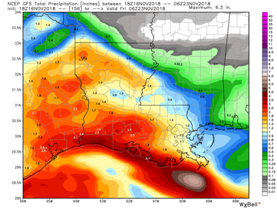
Temperature will be near normal, but the rain chance is something we will have to watch over the coming days. The GFS and the ECMWF have similar timing on the Gulf low and trough coming in but differ on strength of the systems. The UVVs for the system emerging from the Gulf of Mexico into southeast Louisiana are impressive. The amount of WAA is also impressive for this time in November. With these values. It is likely that southeast Louisiana will see some rainfall on Thanksgiving Day. ECMWF QPF maps shows less than a quarter of an inch of a rain in southeast Louisiana and the rest of the precipitation being offset to the west. The GFS has the greatest amount of precipitation occurring off the west as well, but still has over an inch for most of southeast Louisiana.


Thanksgiving Forecast Across the US
My Thanksgiving forecast is football filled with win over Atlanta for the Saints and a win over TSUN for the Dawgs. Weather wise, I haven’t seen weather this quiet is a very long time across the majority of the United States. Good thing it is coming on one of the most traveled weeks of the year though. The only significant weather is the ongoing northeaster, which is moving into the Atlantic and no longer dumping snow on the northeast. A pattern dominated by ridging will give most people a nice, calm Thanksgiving (except those of us in Louisiana).

0 notes
Text
November Severe Weather Threatens Starkville, MS
November 4th, 2018 - November 6th, 2018 (Sunday to Tuesday)
Severe weather is likely Monday night across the southeast. Models have been hinting at a severe weather threat for almost a week now. I will be assisting with balloon launches in Starkville every 6 hours before, during, and after the event beginning at 6pm Sunday night. This week, my blog will follow along with the balloon launches leading up the event on Monday night.
Sunday Evening (0z Monday launch)
Models have been trending towards a weaker surface low pressure system than models were constantly showing late last week. Even with a weaker low, there are still certain parameters that point to the possibility of a severe weather threat for central Mississippi. The 18z Monday GFS wind profiles are supportive of non linear pre-frontal convection with a veering wind profile. The moisture is enough to support severe convection based on the 12z Monday ECMWF and 18z GFS, but the deeper moisture is present further north around the Memphis area. Shear values are still very supportive for severe thunderstorms and tornadoes. Even though CAPE is between 1000-2000 J/kg, the high shear environment will be enough to produce severe weather, as is often seen with nighttime events in the southeast. The Monday 36hr 0z HRRR run showed a line of individual storms pushing through north Mississippi. The timing on this model is much quicker than what was been previously shown by other non CAM models. The timing will be something to monitor as other CAM models hopefully come into agreement by tomorrow morning.
Our first sounding did not show much in regard to the event. I compared our sounding with the 18z GFS sounding valid at the same time and found they were very similar, so the GFS must have a good grasp on the state of the atmosphere in the short term. The 0z sonde we sent up from Starkville observed 150kt winds near 200mb, which is close, if not slightly faster than what they GFS was showing at that point in time. The fastest wind associated with the jet stream according to model guidance was located over Oktibbeha County, so Starkville was an ideal place to launch the balloon to sample the pre-storm environment.


Monday Mid-Day (18z Monday Launch)
By 11am when the balloon was sent up, skies were still foggy and overcast, which is not helping the lacking instability. While I still think tornadoes and the severe threat will be present without excessive instability due to such high shear, more instability would certainly elevate tonight’s threat. An inversion is present around 900mb, which will help to cap the environment until the low-level clouds and fog is able to mix out. In comparison to the Monday 12z NAM, the cloud cover is decrease quicker and more widespread than the model thought. This clearing could lead to increased instability which is currently one limiting factor of tonight’s severe weather. The evaporation of these clouds could lead to cooling of the mid-levels which would also support a more conductive environment for severe storms. The wind profile on the Starkville sounding though are impressive. Winds are still southeast at the surface with decent turning in the low levels. Wind shear is decent as well with 50kt winds present at 700mb and increasing winds all the way up to where the Starkville sounding terminated.


Monday Evening (0z Monday launch)
The Monday 0z launch from Starkville did not show much CAPE, but there was a large hodograph. The most impressive launch from 0z was from the balloon that ULM sent up from Monroe. The hodograph was impressive, and the instability was present unlike it was further to the east. The sounding can be seen below. At the time of the launch, a tornado watch was issued for most of central and north Mississippi. As soon as the watch was issued, multiple tornado warnings were put out for areas in Central Louisiana. I’ve attached an image below of one of the confirmed tornadoes that was occurring at the time of the ULM launch. These cells stayed discrete in this area and the sounding supports this.


Analysis of the Event
Overall, the event had 24 tornado reports across the southeast US. Two of the significant reports came from Louisiana early in the afternoon before the system became linear. CAPE and shear were best in the northern Louisiana area compared to anywhere else while this system tracked through, which explains the strongest tornadoes and most discrete cells. Another area of concern initially was the Memphis area, but due to a pre-frontal wave of convection just hours before the front made it to Memphis, much of the instability had decreased significantly. The storms ahead of the front took QLCS form as they tracked across the state of Mississippi, so the biggest threat for us was embedded tornadoes due to high shear and strong winds. The QLCS did produce an EF-0 just east of Starkville and just west of Columbus (luckily it touched down between the two cities). An EF-2 tornado did damage though to our north as it tracked through the city of Tupelo.

0 notes