
marcospinello
marcospinello
random links to stuff I find interesting on the InternetS
635 posts
Don't wanna be here? Send us removal request.
Last Seen Blogs

suniltelugu
Untitled

tomyo
What's Her Hair

secona
Secona

ceokusut
CEO OF KUSUT

1lars
Men in Sweaters
Text
#1yrago Regulating Airbnb drives down local rents (as well as house prices)
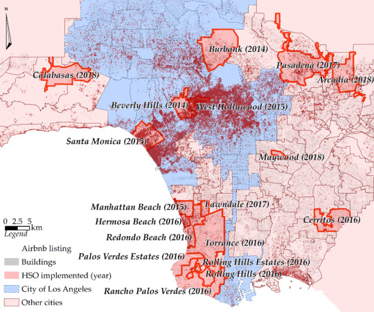
Airbnb has led to much of the rental housing stock in some of the world’s most expensive cities being turned into unlicensed hotel rooms, driving up both rents and house prices even further.
Opponents of regulatory approaches to fix this often say that Airbnb’s contribution to inflation in housing costs and values is negligible, and/or that any benefits from curbs on Airbnb would be canceled by other forces that are driving up housing costs.
But LA County provides a natural lab for evaluating this claim: some of the cities within the county have limited Airbnb and others haven’t, allowing a group of researchers to publish a study that found that limits on Airbnb and other short-term rental platforms does exactly what proponents of the rules promise they will: lowers the cost of rentals, and also the cools down property price bubbles.
https://boingboing.net/2018/12/20/unlicensed-hotels-vs-tenants.html
806 notes
·
View notes

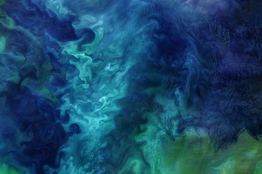
Photo
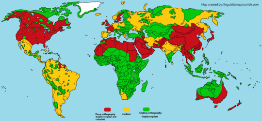
Orthographic depth
Languages have different levels of othographic depth, that means that a language’s orthography can vary in a spectrum of a very irregular and complex orthography (deep orthography) to a completely regular and simple one (shallow orthography).
English, French, Danish, Swedish, Arabic, Urdu, Tibetan, Burmese, Thai, Khmer, Lao, Chinese, and Japanese have orthographies that are highly irregular, complex and where sounds cannot be predicted from the spelling. These writing systems are more difficuld and slow to be learned by children, who may take years. In the medium of the scale there’s Spanish, Portuguese, German, Polish, Greek, Russian, Persian, Hindi, Korean, where there are some irregularities but overall the correspondence of one sound to one phoneme is not that bad. At the positive end of the scale there’s Italian, Serbo-Croat, Romanian, Finnish, Basque, Turkish, Indonesian, Quechua, Ayamara, Guarani, Mayan languages, and most African languages (because there were no history of spelling, so a new one of scratch was made as very regular), they all have very simple and regular spelling systems, with usually a one-to-one correspondence between sounds and letters. These are very easily learned by children.
Orthographic depth has several implications for the study of psycholinguistics and the study of language processing and also acquisition of reading and writing by children.
Note: remember that there’s no objective numbering on the three categories I made, there are more than just these three categories, because it works like a spectrum. Three categories were used just as a means for simplification.
2K notes
·
View notes

Text
North Korea's APT38 hacking group behind bank heists of over $100 million
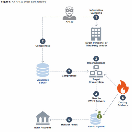
Source: https://www.zdnet.com/article/north-korea-s-apt38-hacking-group-behind-bank-heists-of-over-100-million/
Whitepaper (PDF): https://content.fireeye.com/apt/rpt-apt38
13 notes
·
View notes
Photo
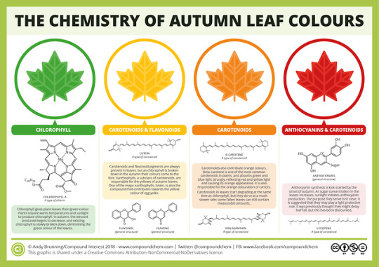
Autumn is here! Here’s the chemistry behind the 🍁 colours we’ll be seeing over the coming weeks: https://wp.me/p4aPLT-sn
2K notes
·
View notes
Photo
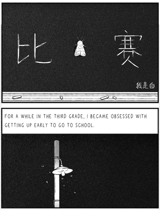
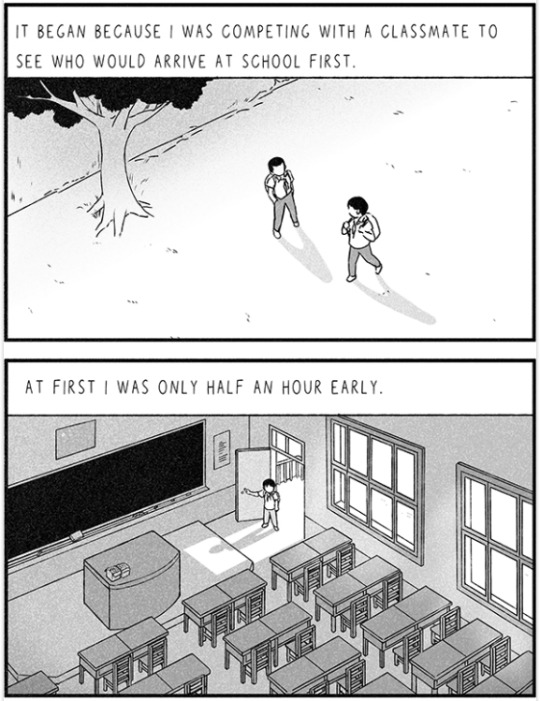
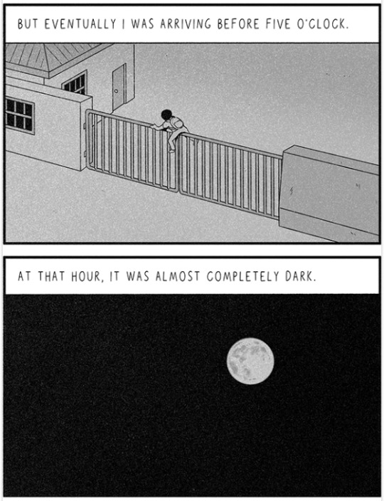
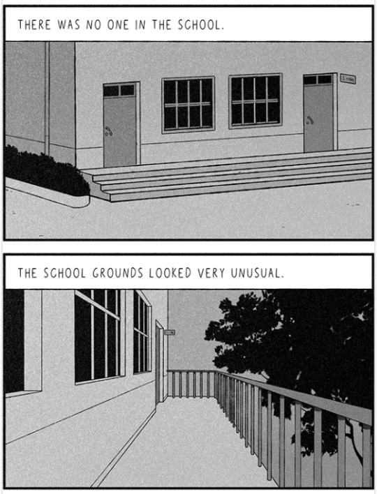

“Competitive“ by Woshibai
Translator: @paradisesystems, Sally
18K notes
·
View notes
Photo

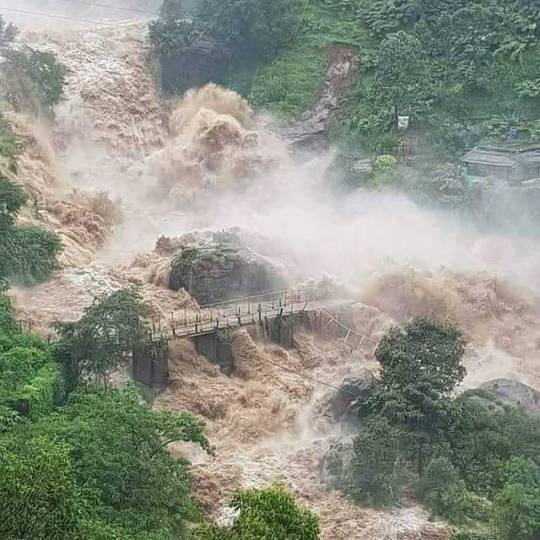

The state of Kerala, India, is experiencing one of the worst floods since 1924. Over 20,000 houses have been damaged completely and 10,000 km of roads have been destroyed. Essential services have taken a hit, with shortages in medical supplies and drinking water reported from several places. A red alert has been issued in 11 of the 14 districts.
324 people have lost their lives since the rains started on May 29. Over half of them - 190 across 14 districts - have died in the last few days. Over 314,000 people have been moved to relief camps across the state with many more still missing or unreachable.
AnboduKochi is a non-profit organisation that has been one of the largest groups to provide relief support in Kochi, they need cash to transport all the donations they have been getting and make sure it gets to the relief camps.
keralarescue.in is an initiative by Govt. of Kerala, Kerala State IT Mission and IEEE Kerala Section for effective collaboration and communications between authorities, volunteers and public
Google has put out a consolidated and pin-dropped list of centres providing rescue ops, including shelters, food and water, medicine and essentials, volunteers, Jeep rescue and ambulances, among others.
In case you are looking for someone stranded in Kerala or have information about someone, use the Person Finder, which crowdsources information, to help.
Below are some ways to donate and help rebuild the lives of those affected.
The Chief Minister’s Distress Relief Fund (CMDRF) is 100% exempt from tax and “is an emergency assistance release mechanism granting immediate relief to families and individuals distressed by calamity, loss of life due to accidents and chronic diseases.”
Amazon lets users donate to one of three NGOs: Goonj, Habitat for Humanity and World Vision India. Once you select one of the three NGOs, you can choose what you want to donate by going through their wishlist
Flipkart allows users to donate to NGO Goonj
Paytm allows users to donate to the CMDRF and matches each donation made rupee for rupee
Oxfam India is on the ground providing dry food, clean water, shelter & long-term recovery.
British Malayali Kerala Floods Relief Appeal if you are living in the UK
Kerala Flood Relief Fund from USA if you are living in the US
Kerala Flood Relief Fund from SMYM Australia or Donate to Help Kerala Flood Victims by Australian India Foundation Incorporated if you are living in Australia
Milaap is a crowdfunding website
Ketto is also a crowdfunding website
Please consider donating any amount of money you can. If you know of any more resources and ways to help, please add to this post.
23K notes
·
View notes
Photo

“I took him to see Brokeback Mountain when it came out. I thought I was challenging him with the choice. But at the end of the film, he turned to me and said: ‘That’s me.’ We’d been married for thirty years. Our kids were still young. I didn’t know what to do. Do I leave? Do I stay? We were ex-pats in another country at the time, so we were all alone. I had nobody to talk to. We went to a therapist to see if it was possible to stay together, and she told us: ‘I’ve seen it work. But only if one person is very discrete and the other is very tolerant.’ So I agreed to try. It’s been ten years. It’s been exhausting in a lot of ways. I asked too many questions at first. I made myself miserable. Now I give him a lot of space. And I get a lot of space in return. I’ve been traveling alone for about two months now. I know what’s going on back home but I don’t ask about it. My friends ask me why I don’t move on with my life. I don’t know the answer. Maybe I’m just too afraid to be alone at this age. But I still feel like he’s my soul mate. We have the same view of the world. We both love children. We love traveling and good food. He really is a good man. He’s just gay. And we’ve had such a good life together, I’m just not ready to stop sharing it.”
4K notes
·
View notes
Text
5 Examples of How Our Satellite Data is Helping the Planet
We could talk all day about how our satellite data is crucial for Earth science…tracking ocean currents, monitoring natural disasters, soil mapping – the list goes on and on.
But did you know there is another way this data can improve life here on Earth?
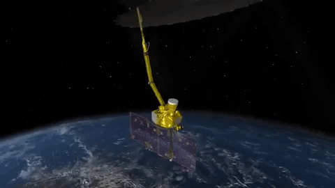
Our satellite data can be used to build businesses and commercial products – but finding and using this data has been a daunting task for many potential users because it’s been stored across dozens of websites.
Until now.
Our Technology Transfer program has just released their solution to make finding data easier, called The NASA Remote Sensing Toolkit (RST).

RST offers an all-in-one approach to finding and using our Earth Science data, the tools needed to analyze it, and software to build your own tools.
Before, we had our petabytes on petabytes of information spread out across dozens of websites – not to mention the various software tools needed to interpret the data.
Now, RST helps users find everything they need while having only one browser open.
Feeling inspired to innovate with our data? Here are just a few examples of how other companies have taken satellite data and turned it into products, known as NASA spinoffs, that are helping our planet today.
1. Bringing Landscape into Focus
We have a number of imaging systems for locating fires, but none were capable of identifying small fires or indicating the flames’ intensity. Thanks to a series of Small Business Innovation Research (SBIR) contracts between our Ames Research Center and Xiomas Technologies LLC, the Wide Area Imager aerial scanner does just that. While we and the U.S. Forest Service use it for fire detection, the tool is also being used by municipalities for detailed aerial surveillance projects.
2. Monitoring the Nation’s Forests with the Help of Our Satellites
Have you ever thought about the long-term effects of natural disasters, such as hurricanes, on forest life? How about the big-time damage caused by little pests, like webworms?
Our Stennis Space Center did, along with multiple forest services and environmental threat assessment centers. They partnered to create an early warning system to identify, characterize, and track disturbances from potential forest threats using our satellite data. The result was ForWarn, which is now being used by federal and state forest and natural resource managers.
3. Informing Forecasts of Crop Growth
Want to hear a corny story?
Every year Stennis teams up with the U.S. Department of Agriculture to host a program called Ag 20/20 to utilize remote sensing technology for operational use in agricultural crop management practices at the level of individual farms.
During Ag 20/20 in 2000, an engineering contractor developed models for using our satellite data to predict corn crop yield. The model was eventually sold to Genscape Inc., which has commercialized it as LandViewer. Sold under a subscription model, LandViewer software provides predictions of corn production to ethanol plants and grain traders.
4. Water Mapping Technology Rebuilds Lives in Arid Regions

No joking around here. Lives depend on the ability to find precious water in areas with little of it.
Using our Landsat satellite and other topographical data, Radar Technologies International developed an algorithm-based software program that can locate underground water sources. Working with international organizations and governments, the firm is helping to provide water for refugees and other people in drought-stricken regions such as Kenya, Sudan, and Afghanistan.
5. Satellite Maps Deliver More Realistic Gaming

Are you more of the creative type? This last entry used satellite data to help people really get into their gameplay.
When Electronic Arts (EA) decided to make SSX, a snowboarding video game, it faced challenges in creating realistic-looking mountains. The solution was our ASTER Global Digital Elevation Map, made available by our Jet Propulsion Laboratory, which EA used to create 28 real-life mountains from 9 different ranges for its award-winning game.
You can browse our Remote Sensing Toolkit at technology.nasa.gov.
Want to know more about future tutorial webinars on RST?
Follow our Technology Transfer Program on twitter @NASAsolutions for the latest updates.
Want to learn more about the products made by NASA technologies? Head over to spinoff.nasa.gov.
Sign up to receive updates about upcoming tutorials HERE.
Make sure to follow us on Tumblr for your regular dose of space: http://nasa.tumblr.com.
3K notes
·
View notes
Video
vimeo
A wind-powered dandelion that clears land mines - another inspiring application of biomimicry
195 notes
·
View notes
Photo

A bust of Elbridge Gerry by Herbert Samuel Adams, U.S. Senate collection. (U.S. Senate Collection)
The “Gerry” in Gerrymandering
By James Worsham | Editor of Publications, NARA
The U.S. Supreme Court this week decided not to get involved in whether certain legislative and congressional districts have been “gerrymandered”—a practice that dates to the early days of the country.
The cases before the court involved a practice in which districts are drawn to favor one person, one political party, or one class of people.
“Gerrymandering” was named for Elbridge Gerry, one of the signers of the Declaration of Independence.
As Governor of Massachusetts (1810–1812), Gerry approved a redistricting plan for the state senate that gave the political advantage to Republicans. Someone observed that one of the districts looked like a salamander, and soon the process was known as “gerrymandering.”
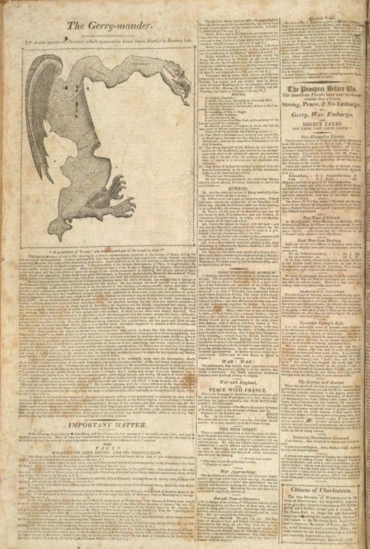
“The Gerrymander: a New Species of Monster” Boston Gazette, March 26, 1812. (Library of Congress)
Since then, “gerrymandering” has for years produced odd-shaped congressional and state legislative districts.
Gerry remained on the scene in the early days of the republic. In addition to signing the Declaration, he also signed the Articles of Confederation.
Find out why Gerry refused to sign the Constitution, over on the Pieces of History blog.
375 notes
·
View notes
Photo
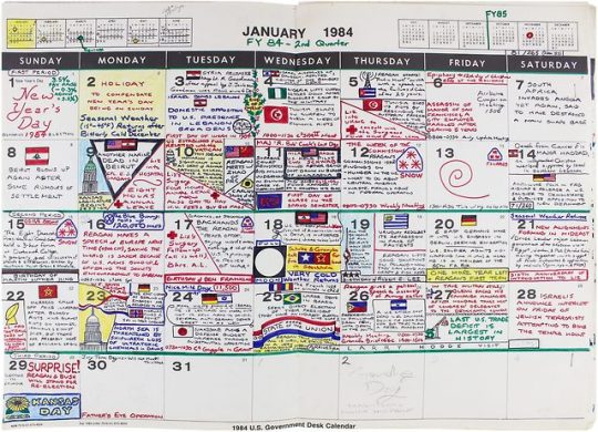
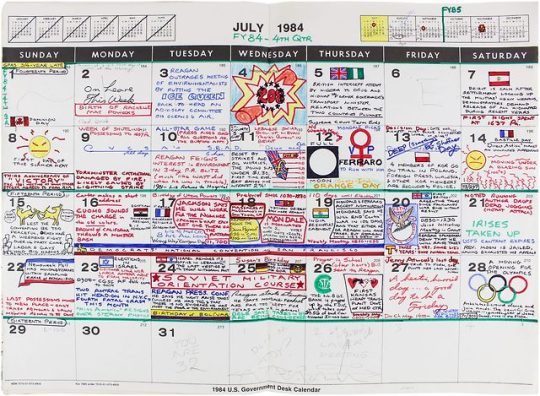
A Disgruntled Federal Employee’s 1980s Desk Calendar
During the eighties, a nameless Cold Warrior grew frustrated in his job for the Department of Defense and poured out his feelings in an unusual way. He was a midlevel (GS-11/GS-12) analyst working at the U.S. Army’s Combined Arms Center, at Fort Leavenworth in Kansas. Every GS-11/GS-12 in that era would have been given a government-issue desk calendar, and this Kansas scribe made the most of his. Like a monk, he labored over his document every day, adding carefully crafted letters and elaborate drawings to what became, over nine years, a remarkably full chronicle of the decade.
168 notes
·
View notes
Photo


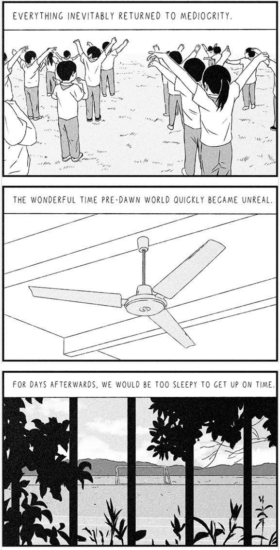
popular crowd
Here’s my patreon if you want to support, I’d really appreciate it!
2K notes
·
View notes
Photo

Page from the 1980 book, MUPPET MADNESS. Saturday Night Frogger? I think the art is by Graham Thompson.
13K notes
·
View notes
Text
If anyone’s interested in following: I created a GitHub repo to keep track of my daily web dev & design learning, and list useful tools & resources!
81 notes
·
View notes