
Title is self explanatory. A meteorologist without credentials. No formal education, no degree. Just mentioning my thoughts on what I see.
Don't wanna be here? Send us removal request.
Statistics
We looked inside some of the posts by meteorologistwithoutcredentials and here's what we found interesting.
Average Info
Notes Per Post
0
Likes Per Post
0
Reblog Per Post
0
Reply Per Post
0
Time Between Posts
3 months
Number of Posts By Type
Photo
1
Text
10
Last Seen Tumblr Blogs


Fun Fact
Tumblr was attacked by a cross-site scripting worm deployed by the Internet troll group GNAA on Dec 3, 2012.
Photo

w1 New adult game 1 561 291 girls online
0 notes
Text
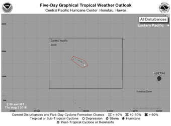
HECTOR (Central Pacific)
LEVEL 1 AREAS: DARK RED Hector is a rapidly intensifying hurricane that has the potential to be a long term threat to Hawaii. It will enter the Central Pacific zone likely on Sunday. As a major hurricane, the threat level is then likely to jump drastically as it is also likely for it to come very close if not directly impact Hawaii. At this time this threat level is being made out of awareness of the potential threat as there is still time for change. However local residents should pay close attention to the development and track of this hurricane.
UPDATES AND COMMENTS: Hurricane Hector is in the neutral zone between the Central Pacific zone and the East Pacific region. However it is rapidly strengthening and is likely to continue as it heads towards the Central Pacific zone. Once it enters this region the threat level may rise considerably for Hawaii, especially if it maintains its current projected track and strength. All locals should monitor this closely. Please share and like this post to help raise awareness. If you know anyone in Hawaii, please direct them to here for future updates.
#tropical storm#Tropical cyclone#Tropical Depression#tropical weather#tropical wave#hurricane#major hurricane#hector#severe weather#severe storm#weather#MWC
0 notes
Text
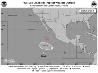
EAST PACIFIC DISTURBANCE ONE: 30%
LEVEL 1 AREAS: DARK RED Some small islands and a very small portion of the west coast of Mexico are under this advisory level out of awareness of the potential storm that may develop. UPDATES AND COMMENTS: An area has a low chance for development. Due to its proximity to some small areas, some threat levels are being issued. Currently only level 1 threats are being issued due to the low chance of development, and also due to its distance from land. If development does occur, or if it appears it could shift closer to land, higher threat levels may be issued accordingly. Although at this time, no major impacts to land are anticipated at this time.
#tropical storm#Tropical cyclone#tropical wave#Tropical Depression#tropical weather#hurricane#weather#severe weather#east pacific
0 notes
Text
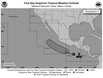
EAST PACIFIC DISTURBANCE TWO: 80%
LEVEL 2 AREAS: DARK RED The disturbance has the potential to form and cause direct impacts to some small islands off the coast of Mexico. At this time a level 2 threat is being issued for this small area. The system has an 80% chance of development at this time and so locals should pay close attention as the threat level could rise considerably in this area. At this time this threat level is being issued as a heightened awareness of the potential storm. LEVEL 1 AREAS: RED Some other small islands and a portion of the west coast of Mexico are under this advisory level out of awareness of the potential storm that may develop close to these areas. Locals should monitor as the system progresses and for any potential rising of this threat level. This is currently out of awareness of the potential storm. UPDATES AND COMMENTS: An area has a high chance for tropical cyclone development that will be near the Mexican coast. Due to its proximity to land, some areas are being issued threat levels. Currently level 1 and 2 threats are being issued, however once development occurs, higher threat levels are likely to be issued, especially if it is going to impact land directly. People along the west coast of Mexico need to monitor this system for potential development and impacts. Please share to raise awareness, especially if in these threat level areas.
#tropical storm#Tropical cyclone#Tropical Depression#tropical weather#tropical wave#hurricane#weather#severe weather#east pacific
0 notes
Text
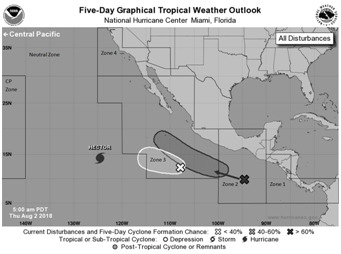
HECTOR (East Pacific)
UPDATES AND COMMENTS:
Hurricane Hector is in the neutral zone between the Central Pacific zone and the East Pacific region. Currently no threat levels are being issued in relation to this storm in the East Pacific. If it gets strong enough while in the neutral zone, a threat level may be issued for the East Pacific region out of awareness of the system although it should not have any impacts on this area directly. After it exits the neutral zone however, any threat levels on the East Pacific region will be dropped, but threat levels in the Central Pacific zone will be increased, likely by a substantial margin. A separate post will be made about this storm for the Central Pacific zone. If you live in Hawaii, please check that post when it comes.
#Hector#hurricane#tropical storm#Tropical cyclone#Tropical Depression#tropical wave#tropical weather#severe weather#severe storm#weather#east pacific
0 notes
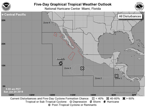
Text
LEVEL 1 AREA: DARK RED Daniel is the newest tropical storm with winds of 40mph. The system is currently not expected to be of threat to land, a few islands closest to the storm could see enhanced thunderstorm activity and dangerous water conditions, but as of now impacts are expected to be minimal. This advisory is primarily out of notice of the storms presence in the region. Although not anticipated, if any change to the storm occurs then the risk value will change accordingly. UPDATES AND COMMENTS: A new tropical cyclone has formed and has been named Daniel, this storm currently isn’t expect to bring major impacts to land at this time. Two other disturbances have a moderate chance for development although currently it appears these areas will behave similarly to Daniel and not be an immediate threat to land. Tropical moisture from these systems may reach coastlines and increase rain/thunderstorm activity in their perspective regions, but at this time no threat level is being issued on these systems. If development occurs, or if it appears that the disturbances will head towards land directly, the threat levels will be issued accordingly. Both the central Pacific and the North Atlantic Ocean appear silent for the time being and no threat levels are being issued for these regions at this time.
#tropical storm#Tropical depression#tropical cyclone#tropical weather#hurricane#weather#severe weather#tropical wave#noaa#nhc#daniel#east pacific#meteorology#forecasting
0 notes
Text
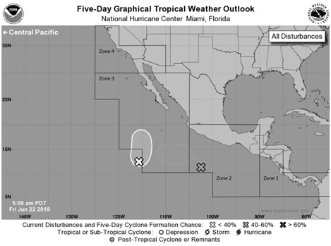
UPDATES AND COMMENTS:
two systems have a chance of developing. Currently no areas are under any threat levels. Several weather models are forecasting for at least one tropical cyclone to form in the region. Currently both are not forecasted to hit land in the short term. If development occurs or if a change in forecast puts land at risk then the threat levels will be issued accordingly. Regardless of development this moist environment with thunderstorms may cause enhanced rain/thunderstorm risk along the coast in zones 1, 2, and 3.
#severe weather#severe storm#forecasting#tropical cyclone#Tropical depression#tropical storm#thunder storm#thunderstorm#rain#coast#hurricane#east pacific
0 notes
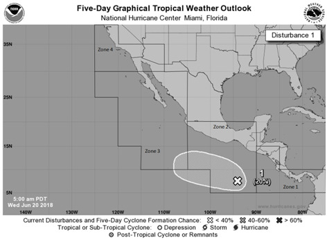
Text
UPDATES AND COMMENTS: The system has a low chance of forming. Currently no areas are under any threat levels. Currently conditions are not conducive for development, however as the system moves northwestward, several weather models are forecasting for a tropical cyclone to form in the region. Currently it is forecasted to remain away from the Mexican coastline. If it develops into a tropical cyclone or if it changes direction to put land at risk then the threat levels will be issued accordingly. Regardless of development this moist environment with thunderstorms may cause enhanced rain/thunderstorm risk along the coast in zones 1, 2, and 3.
#tropical weather#tropical cyclone#severe weather#storm#forecasting#nhc#mwc#tropical storm#Tropical depression#hurricane#weather#science
0 notes
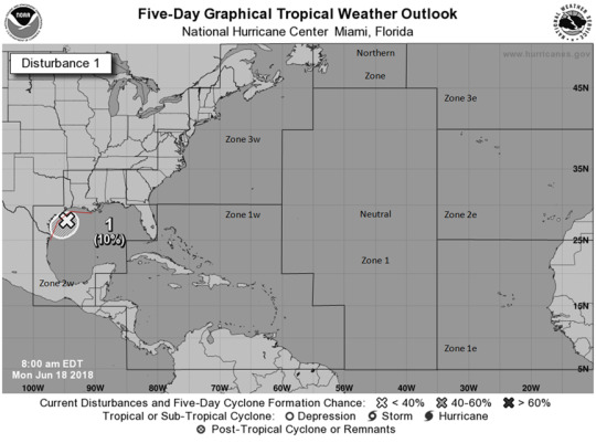
Text
LEVEL 1 AREA: DARK RED An area of thunderstorm activity has a small chance for development. Regardless of development enhanced thunderstorm activity and gusty winds may be possible in this area. A small portion of the northeast Mexican coast, and of the south central USA coast in zone 2w are under this level. UPDATES AND COMMENTS: The system has a low chance of forming but will bring rain and wind to some areas regardless of said development. Changes to the zones have been made this forecast. The West Atlantic zones are followed by a “w” (zone 1w), East Atlantic zones are followed by a “e” (zone 1e), a neutral zone and a northern zone has been added. Storms in the eastern zones won’t impacts threat levels in western zones and storms in the western zones won’t impact threat levels in the eastern zones. Storms in the neutral zone will impact all coastal threat levels on all sides. The new northern zone will be treated as an eastern zone when storms are in zone 3e, treated as a western zone when storms are in zone 3w, and will be treated as a neutral zone for both zone 3e and 3w when storms are in this area.
#tropical cyclone#atlantic#hurricane#storm#severe storm#severe weather#tropical storm#forecasting#tropical weather
0 notes
Text
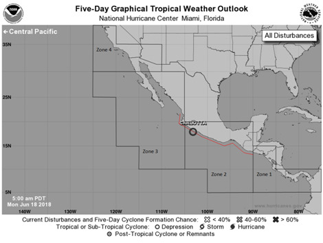
Tropical depression Carlotta
LEVEL 2 AREA: DARK RED Carlotta is a tropical depression. The system is currently very weak however the main threat is not the wind, but rather the heavy rain that is being generated by the storm. This system has stayed just off the Mexican coast for some time, even after the center dies out the rains will likely remain for some time, with gusty winds in some areas possible. Portions of zone 2 in the vicinity of the storm are under this threat level. The storm is center is currently forecasted to die out within the next day or sooner, however if the storm does otherwise the risk may change. There are at least 2 models that forecast strengthening may happen once again, although this currently isn’t part of the official forecast.
LEVEL 1 AREA: RED Although the center of the system is not forecasted to go into these areas, enhanced rain/thunderstorm activity along with some gusty winds in some areas may be possible. Due to this the rest of zone 2 and a small portion of zone 3 right next to zone 2 are under this threat level. As stated in the level 2 threat area, if the storm changes then the threat level may change in response to that. Although this currently isn’t anticipated.
UPDATES AND COMMENTS: Overall the storm has been weakening and is expected to continue to do so until it dies out, there is a slight chance that the storm may move further west and strengthen a bit more, but this isn’t currently anticipated. If such an event does occur, future threat level forecast will reflect such development.
#Tropical depression#tropical cyclone#weather#hurricane#severe weather#mexico#pacific#east pacific#storm#tropical storm#storm prep#forecasting#meteorology
0 notes
Text
NOTICE: I am not a trained meteorologist, and this point system is something that I have developed and so individuals should use their best judgment with these situations. Do detailed research on these storms and get information from local officials as to the best action to take. Life is at stake in these situations so making the right decision is crucial.
0 notes