
On sabbatical hiking in and around the great state of North Carolina.
Don't wanna be here? Send us removal request.
Statistics
We looked inside some of the posts by ncdayhiker and here's what we found interesting.
Average Info
Notes Per Post
3
Likes Per Post
1
Reblog Per Post
2
Reply Per Post
0
Time Between Posts
10 days
Number of Posts By Type
Text
17


Fun Fact
There are dozens of funny blogs to kill time on Tumblr.
Text
Recap
Got lazy toward the end with the blog. Will eventually go back and make entries for the last three including pics.
7/3 - Hawksbill Mountain (not a state park) Hawksbill Mountain Trail
7/2 - Elk Knob State Park (Elk Knob Summit Trail)
6/30 - Stone Mountain State Park (Stone Mountain Loop Trail)
6/14 - Jockey's Ridge State Park
6/6 - Raven Rock State Park
6/5 - Carvers Creek State Park
6/3 - South Mountain State Park
5/31 - Pilot Mountain State Park
5/25 - Lake James State Park
5/23 - Chimney Rock State Park
5/13 - Eno River State Park
5/6 - Hanging Rock State Park
4/23 - Crowders Mountain State Park
4/15 - Morrow Mountain State Park
4/12 - Gorges State Park
4/1 - Lake Norman State Park
3/26 - Haw River State Park
3/11 - William B Umstead State Park
0 notes
Text
#16 - Dismal Swamp State Park - 6/16/2023
Camden County / 2294 U.S. 17 N., South Mills, NC 27976 / GPS: 36.5057, -76.3551 ..... PARK MAP
Fast Facts: This park is in the northeastern part of the state and borders Virginia. It provides access to the Great Dismal Swamp, the largest remaining swamp in the eastern United States. This area features unique and abundant plant life and wildlife, as well as a rich cultural history that intertwines with George Washington, the Underground Railroad, and Prohibition. The 22-mile Dismal Swamp Canal is a popular paddling destination and hosts the annual Paddle for the Border event. The Canal was authorized by Virginia in 1787 and by North Carolina in 1790. Construction began in 1793 and was completed in 1805. The canal, as well as a railroad constructed through part of the swamp in 1830, enabled the harvest and transport of timber. The canal deteriorated after the Albemarle and Chesapeake Canal was completed in 1858. In 1929, the United States Government bought the Dismal Swamp Canal and began to improve it. The canal is now the oldest operating artificial waterway in the country. Like the Albemarle and Chesapeake canals, it is part of the Atlantic Intracoastal Waterway.
Trail(s):
Supple Jack Trail - 1.41 miles / 0:30:54 - AllTrails + Strava
Boardwalk Trail - 0.42 miles / 0:09:06 - AllTrails + Strava
Hike Buddies: Vanessa Helms, Harrison Helms + Jackson Helms
Hike Conditions: sunny + humid, mid to upper 80s at the start.
Comments: Another unique state park in our arsenal, we spent time in the visitor center reading about, among other things, all of the critters found in and around the swamp land. As we started walking down the first trail, we constantly heard movement (critters) just off the path and to be honest, it was a little frightening. One of these fine specimens was a 4 ft king snake in plain slight that slithered away when we came within a yard or two. We took a left to stay on this trail which took us to a very skinny, brushy path. Full-on creepy. Jackson opted to turn around and head back to the visitor center. I let Harrison lead and Vanessa bring up the rear so I could hang in the middle and protect them both .... uh yeah, something like that. Thankfully we didn't detect a lot of movement and sounds other than the ones we were making on this stretch of the path. The exception, the dreaded 'stick' snake that I picked up and tossed to the right of Harrison earning a well deserve expletive as Harrison performed a move that resembled Michael Jackson. When we finished this one, we did the second, less offensive/scary boardwalk trail which entailed a short walk around a raised platform over the marsh. This one was completely harmless.


0 notes
Text
Quick Recap - The first fifteen ...
6/14 - Jockey's Ridge State Park
6/6 - Raven Rock State Park
6/5 - Carvers Creek State Park
6/3 - South Mountain State Park
5/31 - Pilot Mountain State Park
5/25 - Lake James State Park
5/23 - Chimney Rock State Park
5/13 - Eno River State Park
5/6 - Hanging Rock State Park
4/23 - Crowders Mountain State Park
4/15 - Morrow Mountain State Park
4/12 - Gorges State Park
4/1 - Lake Norman State Park
3/26 - Haw River State Park
3/11 - William B Umstead State Park
1 note
·
View note
Text
#15 - Jockey's Ridge State Park - 6/14/2023
Dare County / 300 W. Carolista Drive, Nags Head, NC 27959 / GPS: 35.9642, -75.6330 ..... PARK MAP
Fast Facts: Situated in the north end of Nags Head, this park boasts the tallest dune system on the Atlantic coastline and is popular for kite flying and hang gliding. A second access point on the south side offers a secondary hiking trail as well as a wetland habitat providing for opportunities to swim, paddle, kiteboard and windsurf on the Roanoke Sound. This is the eastern most park in our arsenal and thus is the eastern terminus of the Mountains-to-Sea State Trail.
Trail(s): Tracks in the Sand Trail + freestyle - 1.59 miles / 0:41:44 - AllTrails + Strava
Hike Buddies: Vanessa Helms, Harrison Helms + Jackson Helms
Hike Conditions: sunny, low to mid 80s at the start.
Comments: OMG! What a surprise. What a treat. I had seen a few pictures of this park before we traveled to OBX, however no pictures can do it justice. We were greeted by a 3 ft racer (snake) as we made our way to the visitor center. We spent some time in the visitor center before embarking on the 'hike'. So unexpected, the size and magnificence of the dunes when we crested the first hilly path to the open expanse. It was almost breathtaking. Yes, there is a main trail, but it's not well marked given the openness and the ease of / propensity to simply make your on path. Initially we stuck to it making it to the other side where we spend time enjoying the beauty of the Roanoke Sound. On the way back we freestyled a bit and went south-southeast to the ridge top where people were flying kites and where hang gliders sat idle waiting for the next days class. We descended the steep ridge, getting sand in our shoes in the process, and made our way back to the observation deck before heading out. While it was not much of a hike per se, the uniqueness of the features in this park makes it a crowd (Helms) favorite.


0 notes
Text
#14 - Raven Rock State Park - 6/6/2023
Harnett County / 3009 Raven Rock Road, Lillington, NC 27546 / GPS: 35.4597, -78.9127 ..... PARK MAP
Fast Facts: 40 minutes north of Fayetteville situated approximately half way between Raleigh and Fayetteville, this 4,667 acre park contains the namesake 150-foot crag that adjoins and overlooks the Cape Fear River. This park is located on the most eastern edge of the Piedmont and sits along the fall zone, an area where the hard, resistant rocks of the foothills give way to the softer rocks and sediments of the coastal plain. Raven rock was originally called Patterson's Rock for an early settler who found refuge there when his canoe capsized nearby. In 1854, its name was changed to Raven Rock, inspired by the sight of ravens that formerly roosted on rock ledges. The Siouan and Tuscarora Indians hunted the area until European settlers arrived in the mid-18th century. In 1965, interest grew in preserving the area as a state park, and local citizens organized support for the project. In 1969, a bill establishing the park was passed in the General Assembly.
Trail(s): Ravenrock Loop Trail + Little Creek Loop Trail - 3.92 miles / 1:18:17 - AllTrails + Strava
Hike Buddies: Han Solo
Hike Conditions: sunny, mid to high 60s at the start.
Comments: If I didn't know better, I would have thought I was in the Foothills portion of the state. This one was somewhat similar to Morrow Mountain State Park but with less elevation. What a treat, especially after our hike the day before in Fayetteville. Unfortunate that I did this one on the second day and not the first, because Vanessa opted to rest and enjoy the cooler temps under a cabana nearby the parking lot. I wish she would have hiked this one with me instead (for her sake). I went right on Little Creek Loop Trail and made my way back around to Ravenrock Loop Trail before turning right and descending the stairs that take you to the base of the rock and the shores of the Cape Fear River. I hung out here for short time and admired the beauty. Then I climbed back up those same stairs and filmed it for the fun of it. There were a decent amount of hikers in the park for a Tuesday, perhaps like Alice said, because schools out for summer. My only regret is that I didn't spend more time on the trails at this park.


0 notes
Text
#13 - Carvers Creek State Park - 6/5/2023
Cumberland County / 995 McCloskey Road, Fayetteville, NC 28311 / GPS: 35.1700, -78.8943..... PARK MAP
Fast Facts: 13 miles northwest of Fayetteville proper in the Sandhills, this 4500+ acre park features two access points, one of which is Long Valley Farm, the former home/winter retreat of James Stillman Rockefeller. The park covers lands around Carvers Creek, a tributary of the Cape Fear River, and it borders Fort Bragg or as some now say, Fort Liberty. This park is still in the planning stages and the state intends to purchase additional acreage.
Trail(s): Long Leaf Pine Trail and Fox Squirrel Loop Trail - 5.50 miles / 1:56:36 - AllTrails + Strava
Hike Buddies: Vanessa Helms
Hike Conditions: sunny, 79 at the start.
Comments: We left Charlotte around 10:30a and ventured east slightly more than 1.5 hours. We had lunch outside of Fayetteville before heading downtown and spending a couple of hours walking up and down Hay Street. We then made the short drive to the Sandhills Access of the park around 2:30p. The trails we walked were multi-use and there was significant 'evidence' of horses using them in recent weeks. The first part of the walk was pretty much out in the open and the trail itself was quite sandy. I tried to walk on the edge to establish a better footing. When we peeled off into the woods, it was less sandy and the nearby pines had dropped a large number of their needles on the floor. Just days earlier there was a controlled burn performed here and the air smelled of charred forest. Controlled burns are used a management tool to help reduce the amount of debris that can fuel wildfires. They help protect the park's resources and adjacent landowners in the event lightning, arson or carelessness results in a fire and they are done under strictly defined weather conditions. We saw smoldering logs and small fires on the Fox Squirrel Loop Trail portion. Some of the wildlife didn't survive, however we did see a couple of squirrels and what I believe to be a broad-headed skink. Other than a long walk on a fairly warm day, this was a fairly easy 'hike' with pretty much zero elevation.


0 notes
Text
#12 - South Mountain State Park - 6/3/2023
Burke County / 3001 South Mountain Park Ave., Connelly Springs, NC 28612 / GPS: 35.5963, -81.6000..... PARK MAP
Fast Facts: 55 miles east of Asheville, this park offers ~50 miles of trails for hiking, riding and biking. The Jacob Ford access also offers numerous camping and picnicking facilities. The park covers over 20,000 acres and includes part of the South Mountains, a branch of the Blue Ridge Mountains. High Shoals Falls is the park's most popular feature. Long ago, the Catawba Valley and the gaps across the mountain ranges to the west were major travel routes. These mountains served as a buffer zone between the Cherokee and the Catawba Indians, and the first European settlers in the area farmed the fertile land along the Catawba River. The park was established as a result of recommendations made by a National Park Service study conducted in coordination with the state of North Carolina. While proposals for the park began in the 1940s, land purchase/acquisition did not occur until 1974.
Trail(s): High Shoals Fall Loop, Upper Falls and Headquarters (H.Q.) Trails - 5.13 miles / 2:07:59 - AllTrails + Strava
Hike Buddies: Dave Townsend
Hike Conditions: sunny, 62 at the start.
Comments: It took us about 1 hour 25 min to get there. I picked Dave up at 7a and we were on the trail just after 8:30a. We were smart/fortunate to arrive early because by the time we finished up, the parking lot was jammed packed. So to date, this was/is one of my favorite hikes (the other being Hanging Rock because of the views) probably due to a combination of a number of factors. We entered the High Shoals Falls trail, the most popular, just west of the parking lot and it quickly gave the feel of being in a rain forest, but with less humidity. We opted to split left at the loop which takes you to a series of stairs leading to the falls. The cool temp, the sound of the falls, the picturesque views of the falls, etc made the initial portion of our hike most enjoyable. And then we hit a series of steep stairs that took us up the mountain...a nice little burn. We turned left on Upper Falls trail and tackled a substantial ascent up the rest of the mountain. I noticed a ton of mica (fool's gold) on the ground along the way. Big props for DT who was lugging a 26 lb pack again in preparation for his upcoming 4-day hike in Glacier National Park. We then turned right on the H.Q (Headquarters) trail which eventually teed back into the High Shoals Fall loop before making our way back to the finish. We were off the trail around 11a, then made our way to downtown Morganton where we both devoured a large chorizo burrito from Mountain Burrito and undid the work we had just put in :) A quick trip to the ABC next door where we both scored a bottle of Buffalo Trace made the adventure complete.


0 notes
Text
#11 - Pilot Mountain State Park - 5/31/2023
Surry County / 1721 Pilot Knob Park Road, Pinnacle, NC 27043 / GPS: 36.3408, -80.461 ..... PARK MAP
Fast Facts: 20 miles northwest of Winston Salem, Pilot Mountain and its infamous quartzite plug is the definitive monadnock in the state, if not the country. It is an outlier of the Sauratown Mountains that also includes Hanging Rock. The Saura Indians called it Jomeokee which translates to "great guide" or "pilot". Visitors can drive to the summit area beside Little Pinnacle, but hikers can no longer reach the peak, called Big Pinnacle (2,420 ft). When it was established as the 14th state park in our arsenal in 1968, hikers could climb stairs and a ladder to the top of this commercial attraction; however this ended in an effort to preserve the habitat and nesting sites of the many ravens, raptors, hawks (and the occasional bald eagle). The Pilot Knob trail, formerly Jomeokee trail does still circle the base and affords close up views.
Trail(s): Grindstone Trail, Ledge Spring Trail and Pilot Knob Trail - 2.77 miles / 1:15:27 - AllTrails + Strava
Hike Buddies: Mike Butz
Hike Conditions: foggy, high 60s at the start quickly replaced with sun and low 70s.
Comments: It took us about 1 hour 25 min to get there. I picked Mike up shortly after 10:30a and we arrived just after noon. We had a slight scare a few minutes upon arrival as the skies let out a quick shower and the fog rolled in. When we parked at the summit, visibility was pretty much zero. As such, we took our time getting ready for the start. After 10 minutes, we got down to business, heading west from the parking lot to the Grindstone trail. It wasn't long before the sun peaked through and the fog lifted. And it wasn't long before an easy/moderate hike turned more difficult. The downhill we enjoyed on the first part of the hike was replaced with a strenuous uphill ascent on Ledge Spring Trail which included a handful of significant climbs up natural stairs adjoining the crags of the mountain. Lets just say that I'm glad I've been at his for a bit and that this was not my first rodeo, else ... It was awesome to finally see and admire the crown jewel - Pilot Mountain/Big Pinnacle. We made our way down and around the base and enjoyed views of nearby Hanging Rock State Park. For our hard work, we enjoyed a Maine Beer - Lunch at the conclusion of this hike, probably the smallest one in distance and time to date, but one of the tougher ones. Lastly, we stopped at the Morgan Ridge Brewery in Salisbury on our way home to refuel with some provisions (quesadilla and beer for me).


0 notes
Text
Quick Recap - The first ten ...
5/25 - Lake James State Park
5/23 - Chimney Rock State Park
5/13 - Eno River State Park
5/6 - Hanging Rock State Park
4/23 - Crowders Mountain State Park
4/15 - Morrow Mountain State Park
4/12 - Gorges State Park
4/1 - Lake Norman State Park
3/26 - Haw River State Park
3/11 - William B Umstead State Park
0 notes
Text
#10 - Lake James State Park - 5/25/2023
Burke County / 7321 N.C. 126, Nebo, NC 28761 / GPS: 35.7503, -81.8920..... PARK MAP
Fast Facts: 50 miles east, northeast of Asheville, this park offers a ton of water-based activities (boating, fishing, swimming, etc) on top of the numerous biking and hiking trails. One of the fairly newer parks in the state, established in 1987, the largest portion of the 3,743 acres was added in 2005 in the Long Arm Peninsula and Paddy's Creek areas. The last parcel of 129 acres was added in 2016 for $1.74MM through the N.C. Parks and Recreation Trust Fund and the federal Land and Water Conservation Fund.
Trail(s): West Wimba Trail - 6.46 miles / 1:58:53 - AllTrails + Strava
Hike Buddies: Harrison Helms
Hike Conditions: sunny, mid to high 60s at the start.
Comments: A mid-week hike in a seemingly lesser traveled park/trail meant we hardly saw anyone else out there - in fact, one lone mountain biker. The trail we opted for was lengthier than some and the first one I've done that was designated for both mountain biking and hiking. The layout lended itself to more of the former... The less than good, a bunch of small up and downs, rails, switchbacks and generally a mundane trek. The good, our timing (only had to jump off the course once to allow the passing biker, the pine tress and the pine needle laden floor of the forest ... and the flora. If I hit this park again, I think I will opt for one of the smaller, hiking only trails.


0 notes
0 notes
Text
#9 - Chimney Rock State Park - 5/23/2023
Rutherford County / 743 Chimney Rock Park Road, Chimney Rock, NC 28720 / GPS: 35.4327, -82.2502..... PARK MAP
Fast Facts: 25 miles southeast of Asheville, this park affords some of the best views you will see in North Carolina. Atop the Chimney Rock, one can get a breath-taking panoramic view of Hickory Nut Gorge and Lake Lure. While this 8,014 acre park doesn't offer the same number and distance of trails as other ones in the state, one comes here for the history and attractions. The crown jewel of the hiking experience is the infamous Hickory Nut Falls (404 ft). During the 1800s, Chimney Rock served as the most noted landmark along the Oregon and California Trails giving emigrants a sense of confidence that they were headed in the right direction.
Trail(s): Exclamation Point + Skyline Trails - 2.95 miles / 1:15:03 - AllTrails + Strava
Hickory Nut Falls Trail - 1.59 miles / 0:37:13 - AllTrails + Strava
Hike Buddies: Harrison Helms
Hike Conditions: mostly sunny, mid 60s at the start.
Comments: Probably one of the neatest parks I've been to thus far because of the views, the history, etc. It truly is an attraction and was worth the $17 per person admission. We opted to ride the elevator up instead of taking the stairs to the top of Chimney Rock given our hiking plans immediately thereafter. We spent time on the spire admiring Hickory Nut Gorge, Lake Lure and the vast beyond. In a word - Amazing. From there we ascended a fairly substantial staircase that began Exclamation Point Trail, navigated to the point itself, then Peregrine's Point (2,640 ft) before trekking the Skyline Trail which ultimately took us to the headwaters of the Hickory Nut Falls (though the falls themselves were not really visible on this trail). And then we reversed our steps on this out and back. Afterwards, we enjoyed a bite of lunch at the Skyline deli before knocking out our second, smaller hike to base of Hickory Nut Falls and back. This one was a easier hike compared to the first one of the day. In all, we spent 3.5 hours in this park and I would like to make it back here sometime with the rest of the family.


0 notes
Text
#8 - Eno River State Park - 5/13/2023
Orange County / 6101 Cole Mill Road, Durham, NC 27705 / GPS: 36.0783, -79.0050..... PARK MAP
Fast Facts: Approx 10 miles northwest of Durham, this park spans two counties and has five different access points leading to approximately 30 miles of trails throughout. The 4,319 acre park and its namesake river were pinned for the Eno Native American tribes that lived along the river prior to European settlement. The settlers had substantial farms abound and built a number of gristmills along the river. These 30 or so mills ceased operations in the 1940s.
Trail(s): Buckquarter Creek Trail and Holden Mill Trail - 4.12 miles / 1:53:44 - AllTrails + Strava (time not correct on Strava)
Hike Buddies: Vanessa Helms
Hike Conditions: overcast, low to mid 70s at the start.
Comments: Is two a pattern? Is two a large enough sample size? The night before our hike we traveled to Raleigh to see Stevie Nicks at PNC. The last time I hiked with Vanessa, we saw the Boss the previous night. Maybe I should take her with me more... Our day started with a tasty breakfast at Benchwarmers Bagels in Transfer Co. Food Hall. (one of our favorite spots - picture 1) The #1 sandwich - Avocado, Crispy garlic, radish, charred grapefruit glaze on a wood-fired Za'atar bagel paired with a hot coffee was/is money and the perfect fuel. About a 40 minute drive later west of Durham heading toward Hillsborough, we arrived at Eno River State Park. We chose the fairly tame Buckquarter Creek and Holden Mill trails and opted to go right at the start which meant putting in the work early on and enjoying the fruits of our labor on the backside of our trek. There were a few easy climbs the first half (was proud of Vanessa for being a trooper). The second half our our hike finished along the Eno River and was decently technical. It was cool to see Vanessa prove to herself that she could do it (and enjoy it). There was a ton of bio-diversity; we saw everything under the sun, except a snake which was ok by us. The mild temps coupled with a manageable humidity thanks to a lesser dense woods made the hike a very pleasurable one. Lastly, one of the neater sites we witnessed was the remains of the old Holden Mill (picture 3) which was destroyed by flooding in 1908.


0 notes
Text
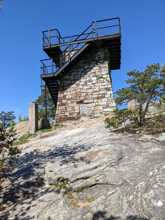
#7 - Hanging Rock State Park - 5/6/2023
Stokes County / 1790 Hanging Rock Park Road, Danbury, NC 27016/ GPS: 36.4119, -80.2541 ..... PARK MAP
Fast Facts: 30 miles north of Winston Salem, this 9,011-acre state park is slightly west of Danbury NC, the county seat of Stokes County. It's located in the Sauratown Mountain range made up of monadnocks that are separated by the nearby Blue Ridge Mountains. The highest point in this state park as well as the aforementioned range is Moore's Knob which rises to 2,759 feet above sea level. In 1936, the first 3,096 acres were donated to establish the park. Additional land acquisitions in the 1970s added the Lower Cascades and the infamous Tory's Den, a rock outcropping rumored to hide British Loyalists during the Revolutionary War. A final land acquisition in 2000 added the Flat Shoals Mountain. The Hanging Rock State Park Bathhouse was added to the National Register of Historic places in 1991.
Trail(s): Moores Wall Loop Trail - 4.86 miles / 2:20:31 - AllTrails + Strava
Hike Buddies: Dave Townsend
Hike Conditions: sunny, mid 50s at the start.
Comments: Located about 97 miles from the house, it took us about 1 hour 30 min to get there. I picked Dave up just after 7a and we were on the trail just after 8:30a. Dave purposely carried a heavy pack as he was/is in training for a massive 4-day, 54 mile hike in Glacier National Park this coming August with daughter Annabelle. Our hike started behind the stone bathhouse next to the lake parking lot and we opted to go left (clockwise) which elongated the elevation gain but made it more manageable. The first part of the loop was compact and carved through dense patches of rhododendron which helped shape the trail. This was pretty neat. About 1.5 miles into the hike, the terrain turned very rocky as we started making our ascent to Moores Knob. We went off path once or twice making it a little more interesting, but quickly found our way back to the trail. Somewhere between mile 2.5 and 3 we reached the pinnacle and climbed up Lookout Tower, a former fire tower where we were treated to a 360-degree panoramic view of the surrounding areas (Dan River basin and Virginia to the North, Winston Salem to the South, Hanging Rock Mountain and Greensboro to the East and Pilot Mountain, Elk Knob, Grandfather Mountain and Mount Mitchell (120 mi) to the West - picture 4). We took in the scenery for a bit before leaving and descending the 684 stone steps of the “endless staircase.” We were off the trail and back to our car shortly before 11:30. We finished with lunch at River Rock Cafe in Danbury before making the return trip home.


2 notes
·
View notes
Text
#6 - Crowders Mountain State Park - 4/23/2023
Gaston County / 522 Park Office Lane, Kings Mountain, NC 28086/ GPS: 35.2133, -81.2935 ..... PARK MAP
Fast Facts: 32 miles west of Charlotte, this 5,217-acre state park in Gaston County is near Kings Mountain, North Carolina and on the outskirts of Gastonia, North Carolina. It includes the peaks of Crowder's Mountain and The Pinnacle, neither of which are true mountains. In the early 1970s, a mining company was preparing to procure the mineral rights, however thanks to grassroots efforts by local citizens, educational institutions, etc, the State was convinced to set aside and protect the area. This was largely in part to significant natural communities, plants and animals, intrinsic beauty, and unique recreational opportunities. In 1973, the State officially designated the area as Crowders Mountain State Park, and it opened to the public in 1974. The Pinnacle was added in 1987, and then another 2,000 acres was added in the year 2000 and officially connected the park with Kings Mountain State Park and Kings Mountain National Military Park (site of a famous Revolutionary battle), both in South Carolina.
Trail(s): Crowders Trail + Rocktop Trail + Backside Trail + Tower Trail + Rocktop Trail + Crowders Trail - 6.46 miles / 2:34:10 - AllTrails + Strava
Hike Buddies: Han Solo
Hike Conditions: mostly sunny, mid to high 60s at the start.
Comments: This is essentially what I deem to be my home park, a 45 minute drive from the house. I decided to step up my game a little today and take on the Rocktop Trail+. These trails had it all - technical in spots, decent elevation gains and length. The start of mile two included a fair amount of rock scaling/climbing and therefore took more time to complete than other splits of the route. I opted to stay left on Backside when it intersected with Tower Trail which allowed me to reach the Tower (see below) ahead of reaching the summit of Crowders Mountain, aka the Overlook, where you can see the Charlotte skyline in the yonder distance. I hung out up there with a number of people and enjoyed the views. Fortunately or unfortunately (I'm not sure), I was able to descend the massive manmade stairs which brings you to this spot if you opted earlier to take a right at the Tower trail intersection. Fortunate in that ascending them is a massive cardio burn (I've done it one time before) but descending them is hard on the knees. So I'm not sure which is worse. Fatigue did set in on my way back down Backside Trail. While never in danger, I did misstep a few times, but thankfully no ankle rolls, only close calls. I was spent at the finish and made my way back home where a cold Hoppy Camper from Innovation Brewing awaited to aid in my recovery.


0 notes
Text
Quick Recap - The first five ...
4/15 - Morrow Mountain State Park
4/12 - Gorges State Park
4/1 - Lake Norman State Park
3/26 - Haw River State Park
3/11 - William B Umstead State Park
0 notes
Text
#5 - Morrow Mountain State Park - 4/15/2023
Stanly County / 49104 Morrow Mountain Rd, Albemarle, NC 28001 / GPS: 35.3737, -80.0735 ..... PARK MAP
Fast Facts: Situated 40-50 miles northeast of Charlotte, the park includes 5,881 acres within the Uwharrie Mountains. When first formed, these mountains stood 20,000 feet above sea level, however erosion has worn them down to little more than high hills that average less than 1000 ft. Morrow Mountain is named for a local citizen of Scotch-Irish descent, James McKnight Morrow, who donated more than 1000 acres to the State on June 29, 1920. The park was opened to the public in the summer of 1939. Within its confines lies the Yadkin and the Pee Dee Rivers as well as the shores of Lake Tillery. The discovery of artifacts in the area attests to the presence of Native Americans at least 12,000 years before European settlement.
Trail(s): Total 5.04 miles / 1hr 50 min
Three River Trail - .75 miles / 17:04 - AllTrails + Strava
Fall Mountain Trail - 4.29 miles / 1:32:57 - AllTrails + Partial Strava
Hike Buddies: Jackson Helms
Hike Conditions: mostly sunny, warm - low 70s at the start.
Comments: Arrived not really knowing what to expect out of this park, but I knew we were in for a treat when we turned down the state park road and a minute later it felt like we were in another world. The windy, hilly roads gave it a definite feel of being in the mountains. The first trail was a bit wet, muddy and not very visible in a few spots. This gave it a little unexpected character. I was waiting for a snake or other critter to make an appearance but this one ended fairly quickly, intersecting the second, longer trail that we embarked upon. The Fall Mountain Trail also started a bit wet but quickly dried out when we started going up. This trail had a gradual ascent to the summit of Fall Mountain before descending down and finishing next to the river. The biodiversity was evident. We saw a snake (fourth pic), lizards, a variety of birds, butterflies, moths and more. The terrain and all of the views we took in was equally diverse making this hike/trail one of my favorite so far.


0 notes
Text
#4 - Gorges State Park - 4/12/2023
Transylvania County / 976 Grassy Ridge Road, Sapphire, NC 28774 / GPS: 35.0960, -82.95105 ..... PARK MAP
Fast Facts: Located near the tripoint of NC, SC and Georgia, this is the western most state park in our arsenal. There are quite the number of waterfalls to see (26 to be exact) and over 56 miles of hiking trails. Adjacent to Pisgah National Forest, it is also one of the newer state parks in NC, established in 1999. The underlying land has a unique history starting with a significant recovery from a manmade disaster in 1916 followed by exchanges from one owner to the next over fifty plus years until the state finally purchased it from Duke Energy Corporation.
Trail(s): Rainbow Falls and Turtleback Falls Trails - 4.30 miles/1:50:11 - AllTrails + No Strava (left watch at home like a big dummy)
Hike Buddies: Jackson Helms (and Vanessa for a small part)
Hike Conditions: sunny, cool - mid 50s at the start.
Comments: Up here in Cullowhee on spring break for a college tour tomorrow, we ventured south a day early down through Cashiers to Sapphire NC to take on this moderately strenuous hike. It was a nice, crisp cool morning to start - we hit the trail shortly after 9:30am. Being mid-week there were not a ton of early-goers. This really was a tale of two hikes - the initial hike was a downhill descent on a well-maintained path that eventually got more technical when we actually left the state park to blaze the more rugged, less-maintained version. After going up and down a number of manmade stairs, we finally arrived to Rainbow Falls (magnificent) and hung out a few minutes before keeping right and making our way down to Turtleback Falls (also magnificent, albeit a little less). We didn't stop there - we took the trail to the end where we we came upon a fence and a private property sign with yet one finally waterfall in our sights. Enter the second hike - coming back out. And what goes down, must go back up. The ascent back up and out of the trail was a mild burn and a good cardio workout. Coming out we passed a number of families making their way down. After rewarding ourselves with some excellent BBQ at Haywood Smokehouse in Dillsboro, a long winters, uh, spring nap was in order.


0 notes