
ratzerart
Immer wieder Island... (Iceland)
Immer wieder Island (Iceland, again and again) - ein speziell auf Island ausgerichteter Fotoblog der über Hyperlinks und Suche wie ein Nachschlagewerk nutzbar ist.
Alle Fotos sind von mir selbst aufgenommen. Ein Reblogging der Fotos wird begrüßt,...
1695 posts
Don't wanna be here? Send us removal request.
Last Seen Blogs

pumptoy
ShinyDoll

jacritfitness
Jacrit Fitness
st9r-g1rl
rust cohle

inzaghi-tai
Sans titre

yonderlogz
Untitled
Photo
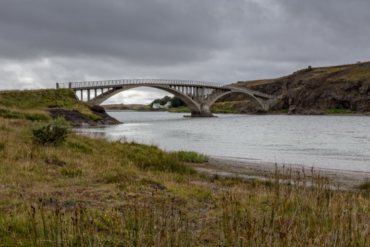
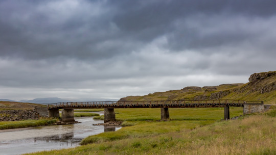
Hvítárbrú: Die Doppelbogenbrücke welche die heutige Straße #510 über den Fluss Hvítá bei Ferjukot führt, wurde 1928 gebaut und stellte seitdem die Hauptverbindung zwischen Nord- und Südisland dar, bis sie von der 1979 gebauten Brücke bei Borganes abgelöst wurde.
The twin-arch bridge which today leads road #510 across the river Hvítá near Ferjukot was built in 1928 and since that time it was the main connection between Northiceland and Souticeland until it was succeeded in this function in 1979 by the newly built bridge near Borganes.
#lensblr#luxlit#telescopical#the photographers society#travel#Reisen#Island#Iceland#Landschaft#Landscape#ratzerArt#Ratzer#photography#photographer#photographers-on-tumblr#original-photographers#artists-on-tumblr#Westen#Brücke#510#Hvítárbrú#Hvítá
110 notes
·
View notes
Photo
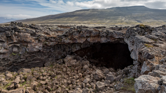
Surtshellir: Die bekannte Lavahöhle im Westen Islands, die früher von Gesetzlosen und Geächteten bewohnt wurde. Die Höhle ist 1310 Meter lang und 8-10 Meter hoch, wobei sie nach Westen hin niedriger wird.
A well-known lavacave in the west of Iceland, which in former time was inhabited by outlaws. The cave is 1310 m long and 8-10 m high but it gets lower at the west end.
#Surtshellir#Westen#Höhle#lensblr#luxlit#telescopical#the photographers society#travel#Reisen#Island#Iceland#Landschaft#Landscape#ratzerArt#Ratzer#photography#photographer#photographers-on-tumblr#original-photographers#artists-on-tumblr
53 notes
·
View notes
Photo
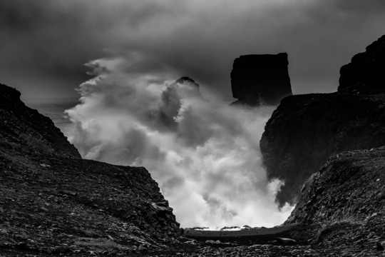
“Neptun’s Face”
Manchmal wirken Wolken und auch Wellen wie Gesichter. Das gilt auch für dieses Bild, das an der Südküste Islands aufgenommen wurde.
Sometimes clouds and waves look like faces. This is also true for this picture which was taken at the southcoast of Iceland.
#Neptun#Wellen#Brandung#Gischt#Süden#lensblr#luxlit#telescopical#the photographers society#travel#Reisen#Island#Iceland#Landschaft#Landscape#ratzerArt#Ratzer#photography#photographer#photographers-on-tumblr#original-photographers#artists-on-tumblr
196 notes
·
View notes
Photo
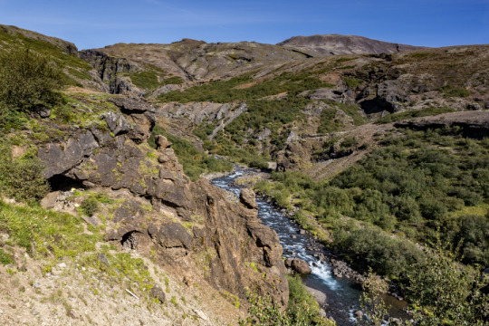
Auf dem Weg zum Wasserfall Glymur, parallel zum Flüsschen Botnsá, das ca. 200 Meter flussaufwärts über einen Baumstamm gequert werden muss.
On the way to the Glymur waterfall in parallel to the Botnsá stream which has to be crossed on a tree trunk in approx. 200 meters upstream.
#Glymur#47#Hvalfjörður#lensblr#luxlit#telescopical#the photographers society#travel#Reisen#Island#Iceland#Landschaft#Landscape#ratzerArt#Ratzer#photography#photographer#photographers-on-tumblr#original-photographers#artists-on-tumblr
56 notes
·
View notes
Photo
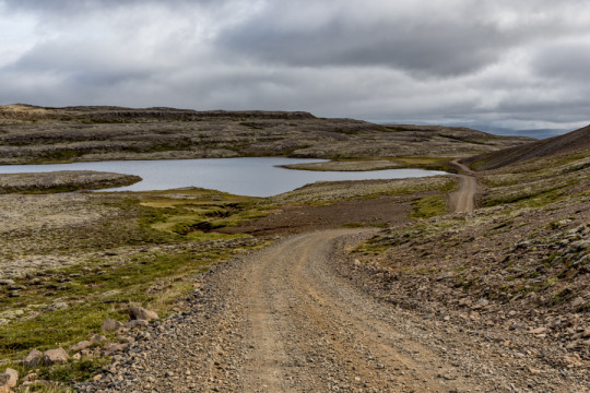
Langavatn: Den bei Anglern beliebten See im Südwesten Islands erreicht man über die #553, danach ist es aber fast unmöglich weiterzufahren.
This lake in the Southwest of Iceland which is liked by anglers can be reached on route #533 but it is nearly impossible to follow the track behind the lake.
#Langavatn#553#Südwesten#lensblr#luxlit#telescopical#the photographers society#travel#Reisen#Island#Iceland#Landschaft#Landscape#ratzerArt#Ratzer#photography#photographer#photographers-on-tumblr#original-photographers#artists-on-tumblr
63 notes
·
View notes
Photo
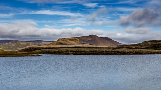
Brúnavatn
Ein kleiner See im Südwesten Islands nahe der #553
A small lake in the Southwest of Iceland near route #553
#Brúnavatn#Südwesten#See#lensblr#luxlit#telescopical#the photographers society#travel#Reisen#Island#Iceland#Landschaft#Landscape#ratzerArt#Ratzer#photography#photographer#photographers-on-tumblr#original-photographers#artists-on-tumblr
67 notes
·
View notes
Photo
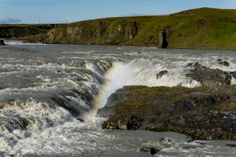
Urriðafoss: Mit einem Volumen von durchschnittlich 360 m³/s leitet der Wasserfall Urriðafoss im Süden Islands über eine Breite von etwa 40 Metern und einer Fallhöhe von 6 Metern den Fluss Þjórsá in Richtung Nordatlantik.
With an average volume of 360 m³/s the waterfall Urriðafoss in the South of Iceland which has a width of approx. 40 meters and a dropheight of 6 meters leads the river Þjórsá down to the North Atlantic Ocean.
#Urriðafoss#Þjórsá#Wasserfall#Waterfall#Süden#lensblr#luxlit#telescopical#the photographers society#travel#Reisen#Island#Iceland#Landschaft#Landscape#ratzerArt#Ratzer#photography#photographer#photographers-on-tumblr#original-photographers#artists-on-tumblr
105 notes
·
View notes
Photo
Alte Brücke an der #53 im Südwesten Islands
Old bridge at road #53 in the Southwest of Iceland.
#Brücke#53#Südwesten#lensblr#luxlit#telescopical#the photographers society#travel#Reisen#Island#Iceland#Landschaft#Landscape#ratzerArt#Ratzer#photography#photographer#photographers-on-tumblr#original-photographers#artists-on-tumblr
54 notes
·
View notes
Photo
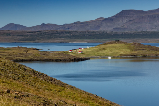
Hvammsvik: Blick von der #47 auf die Ansiedlung Hvammsvik am Hvalfjörður im Südwesten Islands. Ein paar Häuser, ein 9-Loch-Golfplatz und noch etwas mehr.
View from road #47 on to Hvammsvik, a small setteling at the whale fjord (Hvalfjörður) in the Southwest of Iceland. Some buildings, a 9 hole golf course and a little bit more.
#Hvammsvik#Hvalfjörður#47#Südwesten#lensblr#luxlit#telescopical#the photographers society#travel#Reisen#Island#Iceland#Landschaft#Landscape#ratzerArt#Ratzer#photography#photographer#photographers-on-tumblr#original-photographers#artists-on-tumblr
57 notes
·
View notes
Photo
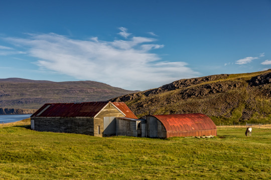
Stall, Scheune und Pferd. Nahe dem Hvalfjörður.
Stable, barn and horse. Near to the whale fjord (Hvalfjörður).
#Stall#Scheune#Hof#Hvalfjörður#lensblr#luxlit#telescopical#the photographers society#travel#Reisen#Island#Iceland#Landschaft#Landscape#ratzerArt#Ratzer#photography#photographer#photographers-on-tumblr#original-photographers#artists-on-tumblr
51 notes
·
View notes
Photo
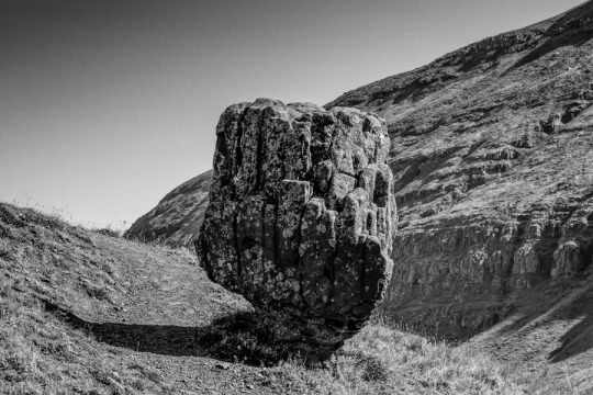
Steðji: Ein Naturdenkmal auf dem Skeiðhóll am Hvalfjörður im Südwesten Islands an der #47 gelegen.
A natural monument on the Skeiðhóll hill at the whale fjord in the Southwest of Iceland located at road #47.
#Steðji#Naturdenkmal#Hvalfjörður#Südwesten#47#lensblr#luxlit#telescopical#the photographers society#travel#Reisen#Island#Iceland#Landschaft#Landscape#ratzerArt#Ratzer#photography#photographer#photographers-on-tumblr#original-photographers#artists-on-tumblr#s/w#schwarzweiß#b/w#Black and White
72 notes
·
View notes
Photo
Hvalfjörður: Man kann die Ringstraße #1 durch einen Tunnel fahren, um schnell nach Akranes im Westen von Island zu kommen, aber wenn man Zeit hat, empfehle ich die Straße #47 um den Walfjord (Hvalfjörður) herum zu nehmen, die tolle Ausbilcke bietet, die in Erinnerung bleiben.
You can drive the ringroad #1 through a tunnel to quickly get to Akranes in the West of Iceland but if you have time I recommend that you take road #47 and circle the whale fjord (Hvalfjörður) with it’s great sights to behold.
#Hvalfjörður#Wallfjord#1#47#Ringstraße#Tunnel#lensblr#luxlit#telescopical#the photographers society#travel#Reisen#Island#Iceland#Landschaft#Landscape#ratzerArt#Ratzer#photography#photographer#photographers-on-tumblr#original-photographers#artists-on-tumblr
74 notes
·
View notes
Photo
Ostfjorde, in der Nähe von Bakkagerði
Iceland, Eastfjords, near Bakkagerði
#Bakkagerði#Ostfjorde#Osten#lensblr#luxlit#telescopical#the photographers society#travel#Reisen#Island#Iceland#Landschaft#Landscape#ratzerArt#Ratzer#photography#photographer#photographers-on-tumblr#original-photographers#artists-on-tumblr
89 notes
·
View notes
Photo
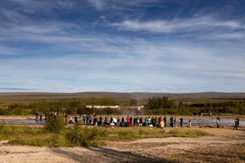
Strokkur im Haukadalur im Süden Islands. Dieser Geysir bricht etwa alle 4-6 Minuten aus und stellt einen der am meisten besuchten Besucher-Hotspots in Island dar.
Strokkur at the Haukadalur valley in the South of Iceland. This Geysir erupts approx. all 4 to 6 minutes and is one of the most visited tourist hot spots in Iceland.
#Strokkur#Haukadalur#Süden#Geysir#GIF#lensblr#luxlit#telescopical#the photographers society#travel#Reisen#Island#Iceland#Landschaft#Landscape#ratzerArt#Ratzer#photography#photographer#photographers-on-tumblr#original-photographers#artists-on-tumblr
56 notes
·
View notes
Photo
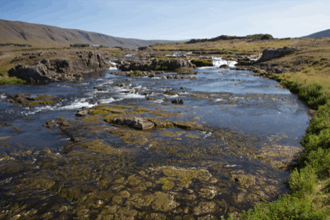
Laxá kurz vor ihrem Zufluss in den Hvalfjörður (Walfjord) an der #47 im Westen Islands
Laxá river near to it’s inlet to the Hvalfjörður (wale fjord) at route #47 in the West of Iceland.
#Laxá#Hvalfjörður#47#Westen#lensblr#luxlit#telescopical#the photographers society#travel#Reisen#Island#Iceland#Landschaft#Landscape#ratzerArt#Ratzer#photography#photographer#photographers-on-tumblr#original-photographers#artists-on-tumblr
68 notes
·
View notes
Photo
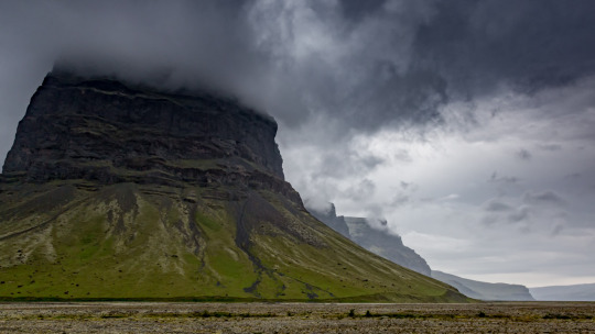
Tittlingsskarð bei Núpshlíð an der Núpsá im Süden Islands.
Tittlingsskarð near Núpshlíð at the Núpsá river in the South of Iceland
#Tittlingsskarð#Núpshlíð#Núpsá#Süden#lensblr#luxlit#telescopical#the photographers society#travel#Reisen#Island#Iceland#Landschaft#Landscape#ratzerArt#Ratzer#photography#photographer#photographers-on-tumblr#original-photographers#artists-on-tumblr
110 notes
·
View notes
Photo
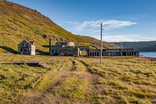
Alte Fischfabrik Eyri am Ingólfsfjörður in der Strandir-Region in den Westfjorden Islands.
Old fish factory at Eyri at the fjord Ingólfsfjörður in the region of Strandir in the Westfjords of Iceland.
#Fischfabrik#Eyri#Ingólfsfjörður#Westfjorde#Westen#Strandir#lensblr#luxlit#telescopical#the photographers society#travel#Reisen#Island#Iceland#Landschaft#Landscape#ratzerArt#Ratzer#photography#photographer#photographers-on-tumblr#original-photographers#artists-on-tumblr
48 notes
·
View notes