
Don't wanna be here? Send us removal request.
Statistics
We looked inside some of the posts by saaky and here's what we found interesting.
Average Info
Notes Per Post
2
Likes Per Post
2
Reblog Per Post
0
Reply Per Post
0
Time Between Posts
8 days
Number of Posts By Type
Text
10
Last Seen Tumblr Blogs


Fun Fact
Kazakhstan’s Minister of Communications and Informatics has blocked the Tumblr site because it contained 60 sites of terrorism, extremism, and pornography in 2015.
Text
Curitiba’s BRT/Sustainable Planning in Brazil
History of Curitiba
Curitiba is located in the South of Brazil. With an area of 432 square kilometers and a population of about 1.8 million, it is a medium-sized developing city.
In 1974, Lerner led a team that created the world's first BRT system, which was a great success. The KU BRT enjoys dedicated express lanes and operates at speeds approximately equivalent to the light rail, with peak hour departures every 60 seconds and destinations reached in 20-25 minutes. Even though there are more than 500,000 private cars in the area, less than 30% of car owners choose to drive to and from work on weekdays; they prefer to travel by BRT because it is more efficient.
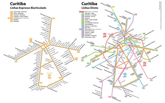
Curitiba's public transport system is an "integrated" public transport system, consisting of more than 390 routes and nearly 2,200 buses, with a daily capacity of more than 2 million passengers, covering more than 1,100 kilometers of roads in the city of Curitiba.
Curitiba's integrated BRT network covers the entire metropolitan area and neighboring towns, catering to the needs of different people traveling.
Transportation
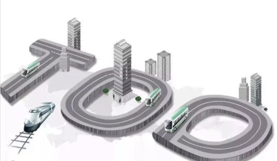
The transportation axis is the backbone of the city. To promote the development of the city along the transportation axes in bands to gather traffic for the bus rapid transit, Curitiba specified the TOD model, which encourages mixed land use development.
The master plan zones all land uses and development densities centered on the roads where the city's bus routes are located. Curitiba's zoning plan stipulates that the blocks on either side of the BRT-only bus corridors located on the triple road structure axis are for high-density development. The model on the right shows what percentage of transportation types are used in Curitiba. Public Transportation is the highest at 45%

Green Transportation
The buses used alternative low-carbon fuel technologies - biofuels In 2009, Curitiba started using biofuel-only energy-efficient buses. Biofuel and hybrid buses produce over 25% less greenhouse gas emissions than regular buses and are cost-efficient and fuel-efficient. The bus system is one of the greatest examples of sustainable transportation in a city in the world. They operate like an above-ground subway system with many bus routes having express lanes on highways.
The buses use alternative low-carbon fuel technologies - biofuels In 2009, Curitiba started using biofuel-only energy-efficient buses. Biofuel and hybrid buses produce over 25% less greenhouse gas emissions than regular buses and are cost-efficient and fuel-efficient.
Housing
Curitiba housing placement is based on the idea of “structural axes” that organize the city. Structual axes are grids designed to define where different structural elements will be built. This tactic is used to create a more organized plan for the city.
The structural axes are known as one of the greatest achievements of Curitiba because they organize the city in a way where everything is easily accessible and placed strategically.

The area on the outside of the structural axis adjacent to the BRT corridor is the residential area, the closer the BRT corridor is, the higher the intensity of development in the neighborhood is. The further away from the BRT corridor the lower the intensity of development in the neighborhoods.
Neighborhood ZR4 on the outside of the structural axis is a medium-intensity residential area with mainly 8-12 story residential buildings. the roads on the outside of the neighborhood are ordinary city roads, It has 3 5-story residential buildings and 2-story townhouses, Curitiba allows for small commercial services such as small stores, pharmacies, and other small commercial services that meet the daily needs of residents.
Density
Density is highest around the axes. decreasing the further away they are from the axes. Housing densities along the axes are an average of 38 dwellings per acre. Closer to the center of the city, the density is even higher.
Green Space
Curitiba has almost 600 square feet of green space per resident. There are about 1,700,000 residents in Curitiba, Brazil. They have planted 1.5 million trees and built 28 public parks. This helped combat flooding. They surrounded Curitiba’s urban areas with fields of grass. This overall saves the city itself the cost and environmental expenses of dams.


Sustainability
Recently the Curitibas housing policies represent a potential pattern for sustainable, effective housing in developing cities.
Many residents in Curitiba follow a well-developed recycling system where paper, glass, plastic, and metal, are all collected to be recycled and turned into new products.

Design and Planning Proposal
Clifton Heights
In Clifton Heights, many nearby amenities are easily accessible to residents. There are many bus stops around the area as well. In 2001, the surrounding area underwent a major change. From once being a vehicular-oriented area to a more pedestrian-friendly area, like the one we live in now. As you can see on the map, the area is made up of Kroger, Walgreens, CVS, and even multiple convenience stores.
Walkability
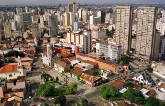
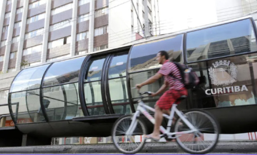
Curitiba Brazil is considered the most “pedestrian-friendly city in the world today.” In 1972, their idea was to take back some of the pavement made for transportation and give it back to the people.
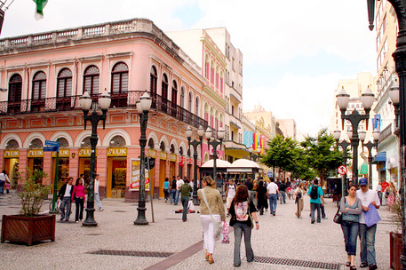
As you can see in the photo above, Curitiba has many restaurants and shops located on the streets, inaccessible to cars. This makes the area safer for pedestrians, allowing them to enjoy their surroundings without having to fear for their safety.
The same cannot be said for Cincinnati. Since this city is more dependent on cars to get around, there are many roads and traffic which makes pedestrian walkways more dangerous.
Although there are some safety measures, drivers seem to disregard walkers' safety by speeding and swerving through intersections. Some drivers have even run red lights as people are crossing the road. If Cincinnati implemented areas where people are free to walk without fear of cars like the image shown of Curitiba, residents will have an easier time accessing nearby amenities.

Concrete example
In London walking accounted for 25.0% of all trips. In 2018, 87.0% of London residents walked at least once a week. Transport for London (TFL) has improved the distance between bus stops and walking routes, increased the recognition of walking networks, and increased the motivation of residents to walk. In addition, London has planned seven scenic and interesting walking routes, including the Capital Circle Walk, the Green Chain, the Jubilee Green Way, the Jubilee Walk, the Lea Valley Walk, the Outer London Track Road and the Thames Path.

Green Transportation
In 2009, Curitiba started using biofuel-only energy-efficient buses. Biofuel and hybrid buses produce over 25% less greenhouse gas emissions than regular buses and are cost-efficient and fuel-efficient.
Buses in Cincinnati could be more sustainable by using biofuels as they are used in Curitiba. These fuels allow less carbon to enter the atmosphere and therefore make their city more clean.

Concrete example
Shanghai in China
2019: Shanghai Jiushi Bus Group and SINOPEC Shanghai Petroleum Branch jointly held the launch ceremony of biodiesel promotion and application, and filled the "first shot" B5 diesel to the bus fuel tank.
End of 2020: For more than a year, the parking lot stations of Jiushi Bus Group have used B5 diesel, with a total supply of nearly 20,000 tons.
The recycling and disposal of kitchen waste oils and fats in Shanghai has basically realized the closed-loop management of receiving all receivable and applying all used. The use of this biodiesel contributes to a significant reduction in greenhouse gas emissions, in line with the near - and long-term sustainability goals of these cities.This example shows that by using biofuels, buses can be more environmentally friendly and also contribute to the sustainable development of cities.
Recycling
Many residents in Curitiba follow a well-developed recycling system where paper, glass, plastic, and metal, are all collected to be recycled and turned into new products.
Cincinnati is extremely polluted, with trash covering the streets. If they followed the same recycling system that Curitiba does, the city would be cleaner and more sustainable.

Concrete example
Hammarby, Sweden has built an underground waste disposal system. The "station" of this system is the more than 450 trash cans scattered throughout Hammarby. These trash cans have no bottom, and the bottom is directly connected to the pipe. When garbage is thrown into a bucket, its underground journey begins. In order to ensure that each package of waste can be smoothly "forward" in the pipe, the transport system uses a powerful suction method, so that the garbage forward speed of 70 kilometers per hour. By establishing effective waste sorting and disposal systems, the cleanliness and sustainability of cities can be greatly improved. This successful practice could serve as a model for cities like Cincinnati.
Connectivity
Due to tons of overcrossing in Curibita, many have decided to switch from public transportation back to using their own vehicles. To deal with this issue, Curitiba is trying to implement a new system called City Vehicle Interconnected (CVI), which is a new kind of BRT that mixes both intelligent mobility with a more ideal interconnected city by using technology. This will include the creation of hybrid & electric buses that can connect up to a total of 5 corridors which is equal to 106 kilometers and 300 stations.
Residents in Curitiba can now spend a small amount of money to travel anywhere they may need, furthermore lessening the use of personal vehicles.
If Cincinnati influenced more people to use metro buses, residents could save money on gas and there would be safer drivers on the roads. The metro could become a new way to travel for those who want to travel safely and spend less money.
Concrete example
Suzhou in China
Bus lanes: The bus lanes in Suzhou cover the main cross-district passenger flow corridors, realizing the close connection and rapid direct access between the central city and the peripheral city, and improving the efficiency of urban public transport.
Integration of bus lanes and subways: Suzhou's bus lanes are effectively integrated with subway lines, for example, buses bring considerable passenger flow to subway stations.
Second Phase Walkability & Connectivity
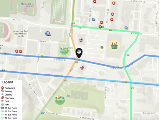
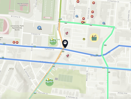
Our vision for this project, was to not only consider our BRT stop & to upgrade it, but to take into consideration all the other bus stops & why people catch buses to this area. Whether they are students, wanting groceries, or simply coming to Short Vine, we wanted to find a solution to all the possible situations & improve them for all to enjoy.
For the second part of our Final Project, we focused on Connectivity & Walkability around our BRT stop. Our BRT stop is located at the intersection of Calhoun & Vine Street.

To improve walkability around our BRT stop, we decided to decrease the sizes of roads, increase size of sidewalks, & implement more greenery around our BRT stop.
This is our very rough draft of our vision for improving walkability / Connectivity.


This is our idea of how the bike lanes would connect. Bike lanes are typically on the right, but theres a bus lane on the right & this works better for our idea.

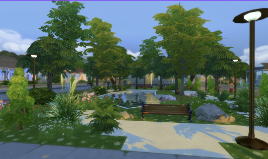
We first noticed that right across from our BRT stop there was an empty lot, to fix this issue of unused space, we decided to place a park here. This park has tons of greenery & has a trail for pedestrians & cyclist.

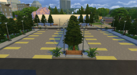
We also noticed how there are a ton of parking lots around this area & many of them arent being occupied at all, leading to space waste. For example, in the upcoming image, there are about 300 parking spaces & half of them were not in use. We decided to place trees and upgrade the parking lot to get rid of some unused spaces, but we had to keep in mind that it is a grocery store and there are busier days than others.

Heres what we did,


Project Plaza
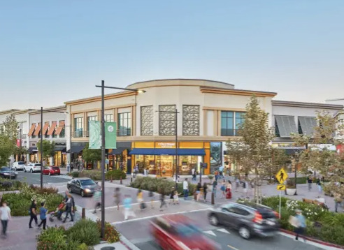
Ontop of adding a park, redesigning parking lots, adding bikes lanes & greenery, we also decided that Short Vine could use an upgrade. There are always tons of cars parking on the street, pedestrians having close eencounters with cars, we decided to upgrade Short Vine! To do this we drew inspiration from Broadway Plaza, Walnut Creek, California.


Sources
0 notes
Text
Can future housing in Cincinnati incorporate any of these elements? Find an example from elsewhere that could be applied in Cincinnati.
Adaptive reuse
Future housing projects can use adaptive reuse by turning old buildings into brand-new homes for residents of Cincinnati. An example of adaptive reuse is the "Church Conversion into a Residence; Chicago, United States." For this project, they reused the structure of the church and kept the unique characteristics such as the windows, which made the house even more beautiful.

In Cincinnati, we see a good example of this type of reconstruction at the Urban Outfitters on Calhoun Street.

Before the renovation

After the renovation
Modular design
Cincinnati has many apartment buildings, especially around the University of Cincinnati. The modular design would be a great technique to use when building these apartments since it'll move construction to a more secluded area. Construction can cause a lot of problems around the area, potentially bothering and endangering residents nearby. If we keep this process more organized, it'll make things a lot easier and people a lot happier. This is especially good when they are creating rooms that are similar to each other.
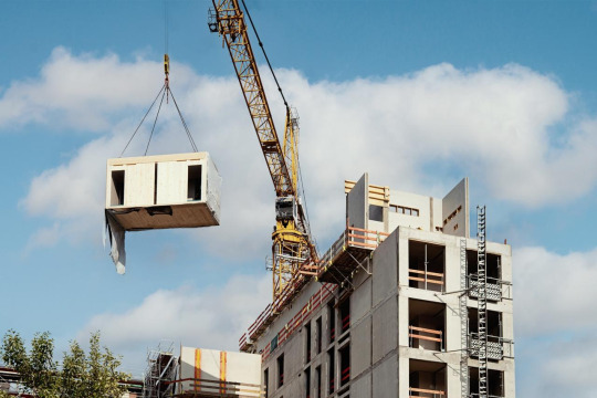
Pre-fab
Cincinnati could leverage prefabricated housing solutions to expedite the creation of livable spaces. Embracing prefabricated buildings would streamline construction processes, ensuring quicker completion without encroaching excessively on space and time for other residents. This approach holds significant promise for constructing apartments and houses in Cincinnati, as prefabricated components can be easily segmented and seamlessly assembled on-site.
Green Technology
Cincinnati can effectively integrate green technology by focusing on enhancing energy efficiency, such as through the implementation of sustainable energy solutions like solar panels and wind turbines. For instance, the Cincinnati Zoo has already begun utilizing solar arrays to generate its own energy, aiming to achieve self-sufficiency solely through renewable sources in the near future. By strategically installing solar panels on the sides and rooftops of buildings, the city can use solar power to generate electricity, thereby significantly reducing its reliance on nonrenewable resources and mitigating its overall energy consumption.

0 notes
Text
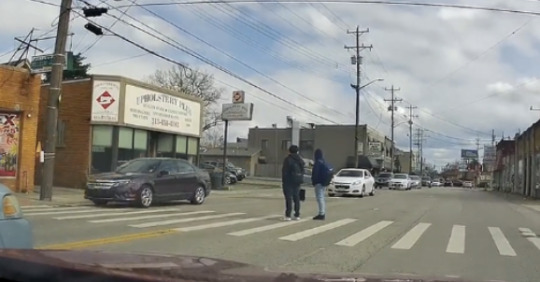
The Future BRT Stop in Cincinnati
Practical Observation


Some examples of good urbanism around the Vine and Calhoun Street bus stop is the close proximity to Kroger, Walgreens, and CVS. This makes it easy for bus riders to walk to these stores and get any essential food or health products that they may need. Some examples of bad urbanism around this bus stop are that there are busy streets and extreme amounts of construction. This makes it more difficult to reach their destination safely, and quickly.
GIS Map
Historical Background
Clifton Heights was the neighborhood that bridged the gap between downtown Cincinnati in the south and the University of Cincinnati in the north. It was the “original” suburb of Cincinnati, but as the population grew rapidly during the early mid-19th century it became cramped. Eventually, the neighborhood would be populated by the wealthy who wanted to live more lavishly and comfortably. They wanted a neighborhood close to the city but also spacious. Soon after the University of Cincinnati gained popularity, Clifton Heights became more dense and became a middle-class neighborhood.
Once Clifton Heights Community Urban Redevelopment Corporation (CHCURC) was formed in 2001, the surrounding area underwent a major change. From once being a vehicular-oriented area to a more pedestrian-friendly area, like the one we live in now. With the rebuilding and remodeling of the area, it became pedestrian-friendly. The bus stop is in a perfect location because it allows people to have walkable areas and easily accessible stores.
0 notes
Text
What are the barriers to TOD in America, and how can cities overcome this issue? Support your view with a successful example of TOD (in or outside the U.S.)
We think the obstacle to TOD in the U.S. is that the whole process of implementation is subject to legitimacy challenges.
The implementation of TOD in the capital markets is often predicated on land appreciation, and due to the large upfront investment, it must be guaranteed that land prices in the area will rise in order to operate. But there are huge risks involved, and most of these risks are borne by the city, not the developer. In order to promote a TOD strategy, the city usually has to provide upfront infrastructure funding, project management and community engagement services. As the founder of TOD, Peter Calthorpe reminds us that "affordable housing must start with affordable neighborhoods." Increasing the supply of affordable housing and providing more jobs must be urged by the government to accomplish this. And it is impossible to do so by relying on the capital markets, which tend to create eye-catching hedonistic environments that employ glamorous, highly educated elites.
Addressing this obstacle depends in large part on the ability of cities to develop appropriate housing strategies to make government affordable.
TOD does not work in isolation; it and affordable housing strategies accomplish each other. As people use public transportation more, the less they spend on transportation, which increases the overall affordability of the community. Extremely low-income households will move farther into the suburbs because they can't afford to pay downtown rents, spending even more than 50 percent of their household income on transportation to do so. While moving to the suburbs reduces the cost of housing, the additional cost of transportation makes it difficult for poor families to survive. Housing compensation in the form of affordable housing could therefore be provided for low-income residents displaced by regional development. Provide affordable housing for low income households within a half-mile radius around each transit hub. This is because the preservation of older homes and the development of affordable housing around transit stations is consistent with the State's macro-strategy of continued support for affordable housing.

The San Francisco Bay Rim project is a success story.
In executing the planning for the TOD project, the management recognized at the outset of the project that public interest and private enterprise complement each other ---- The private economic growth driven by public transportation will be used in part to pay for the cost of public transportation, and the public-private partnership needs to continue throughout the project. The Transbay redevelopment not only plans for residential land to match the office space, but also provides affordable housing at 35% for low-income people. The first project completed in the Transbay Redevelopment Area, Rene Cazenave Apartments, was developed by two local non-profit organizations. The eight-story building consists of 120 apartments with condominiums for the homeless, supportive services, and ground-floor retail space.

With the opening of the Salesforce Passenger Center, the redevelopment of the Bay Rim area opens up a new urban revitalization scenario: one that is transit-oriented and provides a high level of public amenities and a diversity of employment opportunities in a mixed-income community. The development is expected to increase the value of properties within 1.2 kilometers of the Salesforce Terminal by an average of 5%, with an estimated 11% increase in the value of properties directly adjacent to the Terminal.
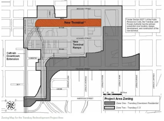
Currently, the implementation of the TOD project not only pushes the construction of the surrounding land, but also attracts high-tech research and development industries to the city center with the perfect transportation system and new public facilities.

0 notes
Text
What are possible ways of alleviating food insecurity in Cincinnati (including UC campus)?
We believe there are 2 ways to do this, strategically placing grocery stores around/near low income neighborhoods. But, for a college campus, we could implement food trucks with fresh foods and lower prices.

Before diving deeper into our answer, it's pivotal to refresh our memories with what food insecurity looks like in Ohio. Going back to the map from the previous lecture, Ohio is sitting at 18.6 percent which is in the higher percentile in the U.S. To fix this problem, we believe you must implement more grocery stores around the city. Currently in Cincinnati Ohio, there are 2,008 grocery stores/supermarkets in Ohio, and 380 grocery stores in Cincinnati. Cincinnati also has 52 neighborhoods and for every 7 neighborhoods, 1 neighborhood is in a food desert. As a comparison, Ohio has 11 million people & Illinois has 12 million. Illinois has 2574 grocery stores/ supermarkets.
When you combine no transportation with low income and high food rates, there are bound to be countless families who can't afford to have consistent, healthy meals. So why is our solution to place grocery stores around low income neighborhoods?
Although there may be higher crime rates in these areas or around these areas, being afraid to place a business in the food deserts, starts to become the reason why they are food deserts. By placing these grocery stores relatively close, but not IN low income neighborhoods, we could see a decrease in robbery rates. This could also lower the amount of low income neighborhoods around Cincinnati. A slight example of this would be how on Seymour Avenue there used to be a Walgreens, but due to its close proximity to a neighborhood & a school, there was a high rate of theft, thus leading to the closing of the said Walgreens, but on Montgomery road, there is a Kroger with bus access that has low rates of robbery & is thriving.

As for a college campus, we do have a Kroger near our campus, which may be a far walk & expensive for students. To go back to the lecture again, the success of food trucks in Chicago, could do wonders here for students on campus. If we were to create a fresh food bus of our own, that could be more beneficial for students. It could decrease the amount of distance you have to travel, and depending on where it is placed, it can be convenient for students to get those foods on their way back from class. Also if we allow discounts or some form of special rewards to students who show their Bearcat cards while purchasing, it would decrease the amount of money students had to pay. The bus could come onto campus every Wednesday and they could switch up what they sold. From fruits to maybe vegetables another week just to help students get their needed food for the week or day.
Not only could these food trucks be beneficial around a college campus, but we could also take this idea and bring it into low income neighborhoods too. If the stores were too expensive, food trucks could also assist to try and alleviate neighborhoods in food deserts. Kroger is 13 minutes away from campus & 21 minutes away if you live in stratford heights, but UC does have bikes you can rent. If your issue was transportation, a bike could decrease the amount of time it takes to get to Kroger. As far as food goes, there are actually resources on campus for students who don't have access to food.

Question: As a UC student, is it difficult to gain access to food on campus? Would you buy from the food truck if this idea became a reality?
0 notes
Text
What types of regional and local transport does Cincinnati need more of in the future? Streetcar, BRT (Bus Rapid Transit), Bike-share, Subway, Monorail (Cable car), or High-Speed Rail? Explain why.
We think Cincinnati needs more Bike-share systems in the future.
Currently, Cincinnati has very few bike lanes, which aren't as safe to its users. Since most people in Cincinnati don't have access to a car, an inexpensive resort would be to ride a bike. If there are fewer bike lanes, residents will struggle will transportation. They will have to resort to different transportation that might cost them money/time.

As you can see in this image there are only 2 protected bike lanes in all of this area. These bike lanes are located in Central Parkway and Clifton Avenue. Although this is a good start to the spread of protected bike lanes, most of these lanes remain narrow and unprotected, subjecting users to increased danger with cars driving all around them. The biggest type of bike lanes in Cincinnati are shared between drivers and bikers. This creates a dangerous environment since bikers have less defense and a slower pace, while cars can speed and honk and potentially even hit bikers when they aren't paying attention. This might influence the resident in Cincinnati to not ride bikes since they might be afraid for their own safety.

Here is an image I pulled from the lecture showing the protected bike lane in Cincinnati. The cement blocks that block the lane from the road are a good way to protect bikers and keep them safer. This technique should be more widespread throughout Cincinnati, giving bikers a way to defend themselves against the potential danger of automobiles.

According to this statistic, most residents agree with the fact that Cincinnati lacks in the amount of bike lanes. They state that they would be more likely to use the bike system if there were more lanes, trails, and paths that they could travel safely on. For the number of citizens of Cincinnati who are unable to afford nice/safe cars or even a ticket for the metro, they are forced to risk their lives on unsafe paths where they may never reach their destination. For the amount of roads, I feel like there's plenty of room to add safe protected bike lanes. This decision would be most beneficial to a lot of the people living in Cincinnati.
0 notes
Text
What’s the “best” density for the design of cities today? Find an example of the city block in Cincinnati. Measure its housing density (units per acre) and explain how its elements make the best quality of urban environment.
The best density for the design of cities today is 21-23 units per acre. I believe this would work best for cities because it allows there to still be an adequate amount of housing while still having a good amount of open space and water features close by.

Here is a screenshot of the 21-23 units per acre density from the lecture. In this picture, there are no demonstrations of monotony, which means there is more variation in the way buildings and homes are created. That means that instead of a city looking like a series of copied and pasted homes with similar characteristics, we see a mix of different materials being used during the architectural process. I think this is very important for the citizens of the city to feel a sort of uniqueness when buying a home.

79.6 is the residential density of this neighborhood that I found in Cincinnati. I believe that this is still a good density because the houses are still somewhat spaced out, as well as there is a park nearby that residents can easily reach by way of car or on foot. It uses the space in a more eco-friendly way by leaving room for trees, parks, and other environmental elements. Although there isnt as much green space, I still think they include as much as they can in places nearby.

Here is a zoomed-out picture of the area surrounding the neighborhood from the first picture. As you can see there is a park in the middle and the top left, which most residential areas can reach easily. Overall this area shares great qualities of an urban environment with aspects of a park as well as a school, a barber shop, and many places to eat. This allows the residents to have everything they may need right around them.
0 notes
Text
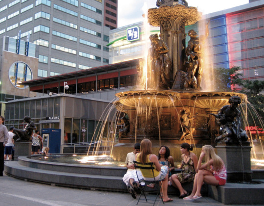
A public square meets Whyte's criteria of human scale——Fountain Square

(source from google image)
Introduction of Fountain Square
Located in downtown Cincinnati, Fountain Square was built in 1871 and renovated in 1971 and 2005. The renovation of Fountain Square has attracted individual booths and even large catering businesses, making the entire plaza a better experience with more amenities. The redesigned Fountain Square provides Cincinnati residents with a place to mingle, dine, and have fun. Now Fountain Square has a new look where people can entertain or just sit and chat.
(source from google image)
Elements related to Whyte's ideas
According to Whyte, the success of a public space is not necessarily related to its size, but to its versatility. Key elements of a successful public space include plenty of inviting places to sit and relax, such as benches, moveable chairs, ledges and steps. Ample sunlight is also important because people are attracted to well-lit areas. Food and beverage vendors can attract more people to stop by. Water features and greenery enhance the aesthetics of a public space and provide a sense of inner peace and comfort. A variety of events in the plaza can attract people and create an active atmosphere.
Fountain Square fits Whyte's idea perfectly. Fountain Square provides a versatile space. It is built in an open area with plenty of sunlight and has a variety of seating options around the fountain. These attract people to sit and relax. The Fountain Square has a large number of vendors including food and beverages. This enhances the social atmosphere of the public space. And it has a stage for performances, which attracts a large number of people to stay and observe. Of course, the trees and fountains in the Fountain Square complement each other and their arrangement creates a more pleasant environment. Fountain Square attracts a large number of people to stay and rest.
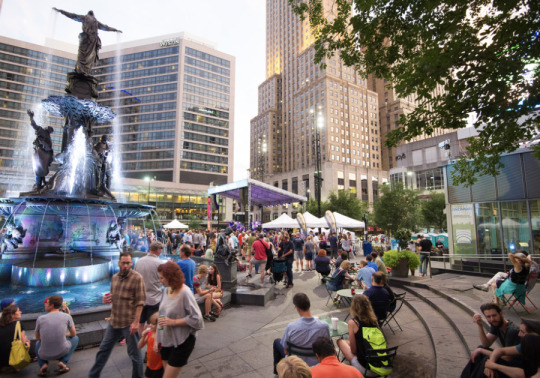

(source from google image)
0 notes
Text
What are lessons from Paris and Chicago that Cincinnati’s neighborhoods can emulate?
Chicago utilizes a roadway to provide citizens transportation over the river, just as they do in Ohio. This makes entering and leaving the state/city a lot easier for citizens and students who might commute to school/work.

Ohio state bridge

Chicago waterfront roadway (1920)
Furthermore, we see similarities in the parks. For example, we have the oldest park in Cincinnati (Piatt Park)

In the lecture, we saw how Chicago used parks to connect open places and unite all age groups. This idea is greatly implemented in Ohio, with many great parks around the different neighborhoods.
Moving on to the organization of Ohio streets. These streets differ the same way the ones in Chicago do based on the location. We see examples of streets in downtown Cincinnati, avenues in Columbus Ohio, and boulevards in Cleveland Ohio. Chicago is built up the same way with these 3 different sectors.
For our neighborhood we chose Over-the-Rhine
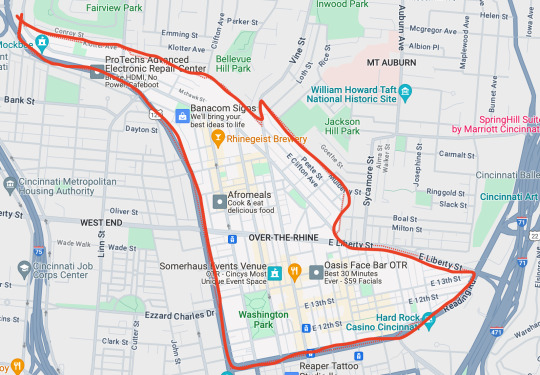
This is a mid-19th-century neighborhood that has many restaurants, shops, parks, venues, and fun activities.
Another main point of Chicago’s was a regional highway system. The majority of this neighborhood is surrounded by a highway system, US-127. This is a major highway because it covers a lot of the eastern United States.
Another big point of Chicago and of Paris too is ecological public space. Such as shopping areas, restaurants, and parks. A big part of the Over-the-Rhine neighborhood that is well-known and attracts tourists is the Findlay Market. This market is the oldest operated public market in Ohio. It has fresh food markets, street performers, and special events to attract people.
The lesson about Paris is that every neighborhood should have at least one park within it. In this neighborhood, there is one big main park: Washington Park. It is a well-known area that many people go through.

Washington Park
Another principle from Paris (and Chicago as seen before) is to have large boulevards for fresh air and light. While this is a pretty big boulevard, it is nowhere near the size of Paris’s and there is less walkability. With the limited walkability, it is not as good as Paris’s since it is sectioned off.
Overall, Over the Rhine follows the same ideals as these two cities (Chicago and Paris) with an abundance of parks nearby, many boulevards, restaurants, and walkability to bring people together. These are all important ideals because they promote environmental well-being between different communities.
(Uses information from the Haussmann Paris lecture along with the Burnham Chicago lecture, both from week 2)
1 note
·
View note
Text
Ideal City——Garden City
What is an “ideal” city?
We agree that the ideal city is similar to a Garden City. It needs to maximize the convenience of the people who live in it, without destroying the ecosystem.
1. It brings together the community, the area is easily walkable, and it organizes everything coherently.
Garden City is a right-sized city that combines the best of the city and the countryside. It connects cities and villages that are within easy walking distance of each other through convenient city roads and railroads, and is able to maximize the character of both cities and villages, providing those who live there with a living and working environment that combines the beauty of the city and the countryside with cleanliness, comfort, and amenities, and with a great deal of self-governance for its residents.
2. The city promotes a more environmentally friendly philosophy and improves the quality of life for its people.
First of all, the garden city can provide a good ecological environment for city residents to live and work normally. Secondly, the garden city provides leisure and recreation venues, facilitates people to get close to nature, satisfies their spiritual pursuits, makes up for the shortcomings of their spiritual life, cultivates their emotions, and has great benefits and helpful effects on urban residents.
3. They have forests, cow pastures, and fruit farms, which help the environment.
Garden cities have great advantages for the protection of the ecological environment compared with other urban construction. Garden cities improve the microclimate of the city and ensure that all ecosystems are healthy and sustainable. Garden cities can protect the soil and water resources of the city and prevent soil erosion. Because of the large number of trees and grasslands in the garden city, the soil and water of the city can be well protected and will not be lost due to human damage.

Source: from lecture one big ideas ideal cities
Dose an example exist?
Brisbane in Australia is an example.
In its green space planning, Brisbane has paid great attention to the integration of urban green space with natural elements such as natural topography, rivers and wetlands. Green space elements such as countryside, semi-rural, open landscapes, public spaces and scenic corridors are protected, designed and managed as a whole. In the suburbs and urban fringes, there are large areas of green space, which are connected to the green network with rivers and wetlands as the backbone, forming a green space system that is "large on the outside and small on the inside, effectively connected".

Source: Brisbane; from google image
Debate Question
Would you want to live in Garden City? Why or why not?
1 note
·
View note