#060910
Text
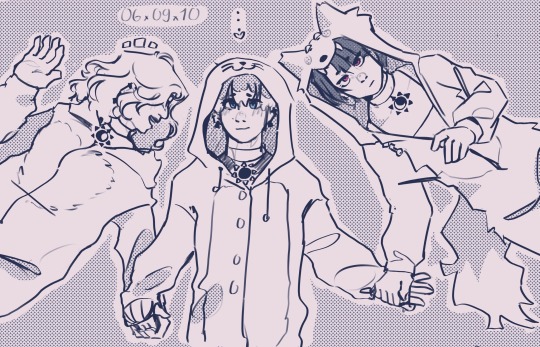
did i ever post this?
#060910#milgram#milgram fanart#kotoko yuzuriha#mahiru shiina#mikoto kayano#theyre in love your honor#could be considered platonic ig
124 notes
·
View notes
Photo

Shroom view by Helena / Funny Bunny on Flickr.
28 notes
·
View notes
Photo
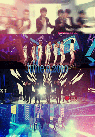
#Infinite#060910#Sunggyu#Dongwoo#Hoya#Woohyun#Sungyeol#Myungsoo#Sungjong#edit#stage perf#comeback#debut#stupid gif limit#-_-
89 notes
·
View notes
Text
Hazardous Weather Outlook for McHenry Co., IL
<pre>FLUS43 KLOT 060910
HWOLOT
Hazardous Weather Outlook
National Weather Service Chicago/Romeoville IL
410 AM CDT Mon Apr 6 2020
Winnebago-Boone-McHenry-Lake IL-Ogle-Lee-De Kalb-Kane-DuPage-
La Salle-Kendall-Grundy-Kankakee-Livingston-Iroquois-Ford-
Northern Cook-Central Cook-Southern Cook-Northern Will-
Southern Will-Eastern Will-Lake IN-Porter-Newton-Jasper-Benton-
410 AM CDT Mon Apr 6 2020 /510 AM EDT Mon Apr 6 2020/
This Hazardous Weather Outlook is for portions of North Central
Illinois...Northeast Illinois and Northwest Indiana.
.DAY ONE...Today and Tonight.
Weather hazards expected...
Significant Thunderstorm Risk tonight...with an associated:
Limited hail risk...up to one inch in diameter.
Limited Flooding Risk.
DISCUSSION...
Scattered thunderstorms are likely tonight across northern
Illinois and northwest Indiana. The overall threat of severe
weather is low, though one or two storms could briefly produce
marginally severe hail late this evening into the first part of
the overnight hours. The thunderstorms may also produce locally
heavy rain.
.DAYS TWO THROUGH SEVEN...Tuesday through Sunday.
Tuesday...
Elevated Severe Thunderstorm Risk.
Wednesday...
Limited Thunderstorm Risk.
Thursday...
Limited Non Thunderstorm Wind Risk.
DISCUSSION:
There is a chance that severe thunderstorms could develop along a
cold front that will move across the area late Tuesday afternoon
and Tuesday evening. It is entirely possible that the front will
not be strong enough to initiate thunderstorm development, in
which case there wouldn't be any severe weather. However, if
storms do manage to develop, conditions would be quite favorable
for them to produce large hail, possibly golf ball sized or
larger, as well as locally damaging winds, potentially in excess
of 70 mph.
.SPOTTER INFORMATION STATEMENT...
Due to the isolated nature of any severe weather threat tonight,
spotters will probably not be needed.
GENERAL STORM MOTION OF THE DAY:
Moving toward east at 25 to 30 mph.
</pre>
https://wxn.io/0xLqU
------------------------------------------------
(c) Copyleft 2020 WxNotify. All wrongs reserved.
You may unsubscribe from WxNotify e-mails by going to https://wxnotify.com/signin.html
and removing the corresponding alert.
from Blogger https://ift.tt/2UIUVzE
via IFTTT
0 notes
Text
Wind Chill Advisory for McHenry Co., IL until 10:00 AM CST 1/6
WWUS43 KLOT 060910
WSWLOT
URGENT - WINTER WEATHER MESSAGE
National Weather Service Chicago IL
310 AM CST Sat Jan 6 2018
...Very Cold This Morning...
/O.CON.KLOT.WC.Y.0003.000000T0000Z-180106T1600Z/
Winnebago-Boone-McHenry-Ogle-Lee-DeKalb-Kane-DuPage-La Salle-
Kendall-Grundy-Will-Kankakee-Livingston-Iroquois-Ford-Newton-
Jasper-Benton-
Including the cities of Rockford, Belvidere, Woodstock, Oregon,
Dixon, DeKalb, Aurora, Elgin, Wheaton, Ottawa, Oswego, Morris,
Joliet, Kankakee, Pontiac, Watseka, Paxton, Morocco, Rensselaer,
and Fowler
310 AM CST Sat Jan 6 2018 /410 AM EST Sat Jan 6 2018/
...WIND CHILL ADVISORY REMAINS IN EFFECT UNTIL 10 AM CST /11 AM
EST/ THIS MORNING...
* WHAT...Very cold wind chills expected. The cold wind chills
will cause frostbite in as little as 30 minutes to exposed
skin. Expect wind chills to range from 15 below zero to 25
below zero.
* WHERE...Portions of and northwest Indiana and central, east
central, north central and northeast Illinois.
* WHEN...Through 10 AM CST today.
PRECAUTIONARY/PREPAREDNESS ACTIONS...
A Wind Chill Advisory means that cold air and the wind will
combine to create low wind chills. Frost bite and hypothermia can
occur if precautions are not taken. Make sure you wear a hat and
gloves.
https://goo.gl/U6aasq
------------------------------------------------
(c) Copyleft 2018 WxNotify. All wrongs reserved.
from Blogger http://ift.tt/2m4gARk
via IFTTT
0 notes
Last Seen Blogs