#AlwarqaSurveyEngineering
Explore tagged Tumblr posts
Visit Tumblr Blog
Explore Tumblr blogs with no restrictions, modern design and the best experience.
Last Seen Tumblr Blogs


Fun Fact
The total number of visits Tumblr.com received during January 2021 is 327 million.
Photo

Alwarqa Survey conducts large scale Transport Surveys required for developing city-wide transport demand models and manual Trip Generation. In addition, we offer a full range of traffic engineering services. We are highly capable of providing full assistance with intelligent transportation, parking management, security, communications, integrated systems in traffic management.
For More Details
EPhone:- +971-4-2676170
Email:[email protected]
#AlwarqaSurveyEngineering TrafficSurvey RealTimeData TrafficDataCollection RoadSurveys#AlwarqaSurveyEngineering#TrafficSurvey#realtimedata#TrafficDataCollection#RoadSurveys
0 notes
Photo

With many years of research and real life experience in all territories of the #GeographicalInformationSystem (GIS) domain, we provide successful and accurate execution of your GIS related projects. For any research project, the essential and important point with #GISmappingdata is registering a map with the correct real world coordinates. #AlwarqaSurveyEngineering leverages the power of Geographic Information Systems (GIS) to analyze, manage, and display environmental data. We use GIS Service in 90% of our projects. For More Details Phone:-+971 42676170 Email:[email protected] Website:-http://www.alwarqasurvey.com/gis-services-in-ras-al-khaimah
0 notes
Photo

#GIS software adds intelligence to spatial data, whether the info is generated within the field with #GPS or remotely with lidar and photo grammetry. A geographic information system (GIS) is a system designed to #capture, store, manipulate, analyze, manage, and present spatial or geographic data. #AlwarqaSurveyEngineering leverages the power of Geographic Information Systems (GIS) to analyze, manage, and display environmental data. We use GIS Service in 90% of our projects. Our GIS analyst are capable of capturing data from many different sources and in many different formats, including local, state, and federal datasets, aerial and satellite imagery, digital elevation models (DEMs), #CADdrawings, KML & KMZ files, client files, and GPS data collection.
For More Details
Email Id:[email protected]
Phone no:-+97142676170
Website:- http://www.alwarqasurvey.com/gis-services-in-ras-al-khaimah
0 notes
Photo

#Progressmonitoring enables to steer the project as per the plan thus saving time and making the best use of resources involved. UAV Based progress monitoring is utilized for construction/deconstruction activities, #pipelinerouting by infrastructure developers, city planners, highway developers, oil and gas companies, water infrastructure developers. #AlwarqaSurvey has proven track record on #progressmonitoringinAbuDhabi For More Details Phone:- +971-4-2676170 Email:[email protected] Website:-http://www.alwarqasurvey.com/progress-monitoring-in-dubai
#Progressmonitoringservices#progressmonitoringinAbuDhabi#progressmonitoringinDubai#AlwarqaSurveyEngineering
0 notes
Photo

#Progressmonitoring at regular intervals enables to visualize the growth of the project as well as reduces the chance of any possibility of delay /failure at very primal stages. Progress monitoring enables to steer the project as per the plan thus saving time and making the best use of resources involved. #AlwarqaSurveyEngineering has a good and experienced team of #ProgressMonitoringInDubai & UAE.
For More Details
Phone:-+971-4-2676170
Email:[email protected]
Website:-http://www.alwarqasurvey.com/progress-monitoring-in-dubai
0 notes
Photo

#HYDROGRAPHICSURVEY are made to acquire data required to chart and/or #mapshorelines and bottom depths of streams, rivers, lakes, reservoirs and other larger bodies of water. This type of survey is also of general importance to navigation and to development of #waterresources for flood control, irrigation, electrical power, and water supply. #AlwarqasurveyEngineering is the best #HydrographicsurveyinAbuDhabi.
For More Details
Phone:-+971-4-2676170
Email:[email protected]
Website:-http://www.alwarqasurvey.com/hydrographic-survey-in-dubai
#HYDROGRAPHICSURVEY#HydrographicsurveyinAbuDhabi#AlwarqasurveyEngineering#waterresources#mapshorelines
0 notes
Photo

#AlwarqaSurveyEngineering is a top multidisciplinary #BIMServices Provider in all aspects of BIM specialized in #ArchitecturalBIM Services. We offer comprehensive BIM Architectural Services to clients globally. We specialize in delivering building information modeling – BIM services to revolutionize #buildingdesign, engineering, and construction processes, enabling project stakeholders to collaborate better and reduce the cost and time.
For More Details
Phone:-+971-4-2676170
Email:[email protected]
Website:-http://www.alwarqasurvey.com/revit-and-bim-services-dubai
0 notes
Photo

#GIS is a tool used in problem-solving and decision-making process and for visualization of data in a spatial environment. Our Team always works on GIS data conversions and prepares #electronicmaps using Geographic Information Systems (GIS) technology by utilizing the paper or #electronicdata that has been either captured by the clients or collected otherwise. If you want #GISServiceinAbuDhabi, #AlwarqaSurveyEngineering is the best option in terms of quality and productivity. We were one of the first survey companies in Abu Dhabi to offer GIS Services in Abu Dhabi.
For More Details
Phone:-+971 42676170
Email:[email protected]
Website:-http://www.alwarqasurvey.com/gis-services-in-ras-al-khaimah
0 notes
Photo

#LASERSCANNING is a relatively new technology, having been used as a precise survey instrument only. Now, it is quickly becoming the new industry standard as a way to make very #accuratemeasurements in complicated environments. #3DLaserScanning is a non-contact, non-destructive technology that digitally captures the shape of physical objects using a line of laser light.3D Laser Scanning by #AlwarqaSurveyEngineering is fast becoming the industry norm for precise surveying in #highprecision and high-value technical environments.
For More Details
Phone:- +971 4 2676170
Email:[email protected]
Website:- http://www.alwarqasurvey.com/
0 notes
Photo

#LASERSCANNING is a relatively new technology, having been used as a #precisesurvey instrument only. Now, it is quickly becoming the new industry standard as a way to make very accurate measurements in complicated environments. It has an effective range of 400’ to 500’. With several “scan” setups inside a room or of a building, a complete #3Dmodel can be made of the existing conditions. These models are then used to create 2D civil or architectural drawings, 3D computer models, and final survey documents. Alwarqa constantly aims to touch new heights and become one of the acclaimed company of #3DLaserScanninginAbuDhabi. For More Details Phone:-+971 42676170 Email:[email protected] Website:-http://www.alwarqasurvey.com/
#3DLaserScanninginAbuDhabi 3DLaserScanninginDubai#3DLaserScanninginUAE#LASERSCANNING#Alwarqasurveyengineering
0 notes
Photo
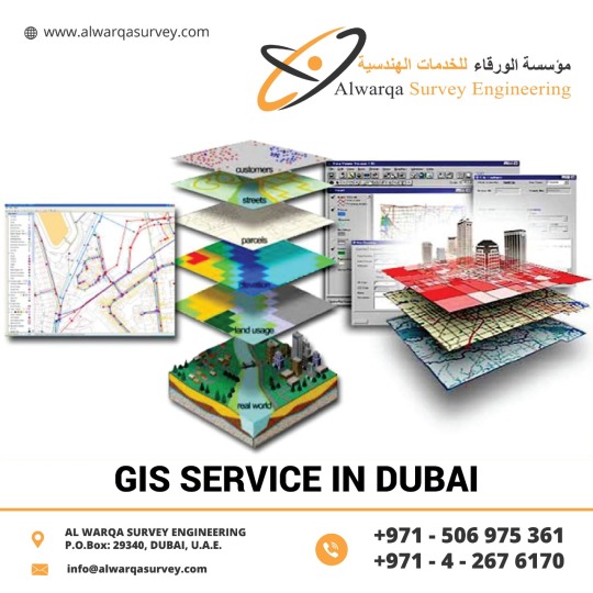
#GeographicInformationSystems can visualize spatial information, It has the power to create maps with the images.#GIStechnology offers time management. It has high accuracy, It presents higher predictions and analysis. If you want #GISServiceinDubai, UAE & Abu Dhabi #AlwarqaSurveyEngineering is the best option in terms of quality and productivity. AlwarqaSurvey Engineering provides GIS services with an all-inclusive solution for spatial data management to government and industrial organizations through #GISremotesensingservices. For More Details Phone:-+971 42676170 Email:[email protected] Website:-http://www.alwarqasurvey.com/gis-services-in-ras-al-khaimah
0 notes
Photo

#BIMservicesinAbuDhabi is one of the Best in #AlwarqaSurveyEngineering provides end to end solutions to maximize the customer efficiency in #BIMModeling, BIM Drafting and Drawing Services, #BIMAutomation, BIM implementation, BIM Coordination and MEP Clash Detection and BIM Integration. We specialize in #BIMStructural, MEP BIM, Rendering and Walkthrough, #ParametricRevitFamilyCreation.
For More Details
Phone:-+971 42676170
Email:[email protected]
Website:- http://www.alwarqasurvey.com/revit-and-bim-services-dubai
0 notes
Photo

#AlwarqasurveyEngineering Provides #BathymetricsurveyinUAE .Bathymetric surveys allow us to measure the depth of a water body as well as map the #underwater features of a water body. Bathymetric surveys provide information about the unique shape and features of #submergedterrain, which can be used to develop detailed maps of the riverbed, lakebed, or seafloor. We at Alwarqa Survey provides solutions that meet the client's #hydrographic requirements, from the land-sea boundary to full ocean depth, using acoustic, optical and #remotesensingtechnology.
For More Details
Phone:-+971 42676170
Email:[email protected]
Website:- http://www.alwarqasurvey.com/hydrographic-survey-in-dubai
0 notes
Photo

Solar Inspections In Dubai | Abu Dhabi
The output of #solarpanels decreases at a rate of 0.5% to 3% each year. Timely detection of such defects is important to fix anomalies to avoid severe drops in #energyproduction. A drone equipped with a thermal camera can inspect a solar farm with higher speed and accuracy. Utilizing #DroneInspection will typically reduce cost of inspections by approximately 30-50%.We at #AlwarqaSurveyEngineering Offers the best #Solarinspectionindubai,UAE and & Abu Dhabi.
For More Details Phone:-+971 42676170
Email:[email protected]
Website:- http://www.alwarqasurvey.com/solar-inspection-in-dubai
0 notes
Photo

#3DLASERSCANNINGInAbuDhabi is a relatively new technology, having been used as a #precisesurvey instrument only. Now, it is quickly becoming the new industry standard as a way to make very #accuratemeasurements in complicated environments. This is precisely why using this technology is the best solution for measuring as-built condition. For More Details Phone:-+971 42676170 Email:[email protected]
0 notes
Photo

#AlwarqaSurvey providing vast range of services in marine surveys which incorporates #BathymetricSurveyinUAE and #marinegeophysicalsurveys, oceanographic investigation, diving and #coastalengineeringservices. Most surveys are primarily concerned with water depth. The nature of the sea floor material because of the implications for anchoring, dredging, structure construction, pipeline and cable routing and fisheries habitat. #SONAR (Sound Navigation and Ranging) uses sound waves to find and identify objects in the water and to determine water depth.
For More Details
Phone:-+971 42676170Email:[email protected]
Website:- http://www.alwarqasurvey.com/hydrographic-survey-in-dubai
0 notes