#ExcelToMap
Explore tagged Tumblr posts
Visit Tumblr Blog
Explore Tumblr blogs with no restrictions, modern design and the best experience.
Last Seen Tumblr Blogs


Fun Fact
In Q3 of 2020, 31% of US users access the Tumblr app daily.
Text
How to Geocode Excel Data into a Map?
Introduction
Turning raw Excel data into a visual map can be a game-changer for businesses, researchers, and urban planners. Whether you need to analyze sales territories, track deliveries, or study demographic trends, mapping your data helps unlock insights that spreadsheets alone can't offer. This article will walk you through the process of geocoding Excel data and transforming it into an interactive map.

What is Geocoding?
Geocoding is the process of converting addresses or place names into geographic coordinates (latitude and longitude). Once geocoded, this data can be visualized on a map for better spatial analysis.
Steps to Geocode Excel Data
1. Prepare Your Data
Before uploading your Excel file, ensure it contains:
Address fields (Street, City, State, ZIP Code, Country) OR latitude & longitude columns.
A clear and consistent format without duplicate entries.
2. Use an Online Geocoding Tool
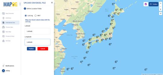
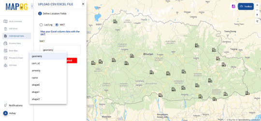
Several platforms offer geocoding services where you can upload Excel files and generate maps. Pick one such tool allows users to geocode their data seamlessly like MAPOG, making mapping a hassle-free experience.
3. Upload and Process Your File
Import your Excel file (.csv or .xls format).
Map the appropriate columns to ensure accuracy.
Run the geocoding process, which assigns latitude and longitude to each entry.
4. Visualize Your Data on a Map
Once geocoded, your data points will appear on an interactive map. You can customize it by:
Changing basemaps (road, satellite, hybrid views).
Applying color-coded categories for better analysis.
Adding additional attributes like time zones, demographics, or custom fields.
Real-World Applications of Geocoded Maps
Business & Sales Tracking
Companies can map customer locations to optimize delivery routes.
Sales teams can analyze which regions have the highest conversions.
Urban & Environmental Planning
City planners can study population density and infrastructure needs.
Environmentalists can track pollution sources and their impact zones.
Healthcare & Public Services
Hospitals can map patient distributions to allocate resources efficiently.
Emergency responders can analyze risk-prone areas for better preparedness.
Tools to Explore
Platforms like MAPOG provide useful tools for geocoding and mapping. The Upload CSV-Excel tool is specifically designed to help users transform spreadsheet data into actionable maps while supporting formats like CSV, XLSX, XLS, ODS . If you're looking for a user-friendly, powerful way to visualize data where you can upload both latitude, longitude and WKT data, it's worth exploring.
Conclusion
Geocoding Excel data into a map can simplify complex datasets, reveal patterns, and enhance decision-making. Whether you're in business, urban planning, or research, mapping your data brings it to life.
Ready to get started? Try out mapping tools and see how geocoding can elevate your workflow!
0 notes