#Garmin gps marine
Text
New Garmin Marine work!
Garmin Marine GPSMAP16x3 in Italy
The GPSMAP16x3 chartplotter and a Garmin Marine reel. This was a treat to head to Italy and shoot around Portofino. An absolutely stunning location on beautiful boats with the Spanish based production company Let’s.film.
North Carolina was a gem, too, albeit not the most ideal weather for shooting. All-in-all, these are the moments of full appreciation for what…

View On WordPress
#boating#Cameron Karsten#Commercial Photography#director#film#Garmin Marine#GPS#Italy#Let&039;s.film#Motion#navigation#North America#product#recreation#Subconscious Productions#video
0 notes
Text
#furuno#garmin#gps#lowrance#simrad#raymarine#radar#marine electronics#PCB#Circuit Board Repairs#Electronic Repairs
0 notes
Text

Find all Garmin Marine GPS, Chartplotters, Autopilots, Radars, and accessories all in one place. Being a authorized dealer makes Marine Tech an authority on all Garmin products. Our team of qualified Garmin marine electronics experts are able to guide you through the entire process of putting together your dream Garmin marine electronics package.
1 note
·
View note
Text
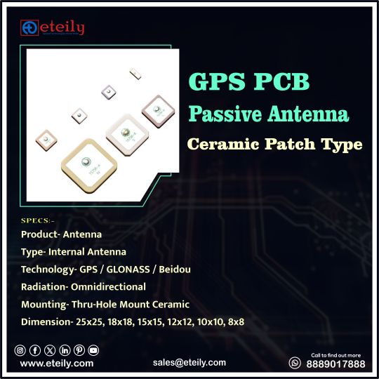
Eteily Technologies India Pvt Ltd
GPS PCB Passive Antenna Ceramic Patch Type
SPECS :
1. Product- Antenna
2. Type-Internal Antenna
3. Technology- GPS/GLONASS/Beidou
4. Radiation-Omnidirectional
5. Mounting-Thru-Hole Mount Ceramic
6. Dimension-25x25, 18x18, 15x15, 12x12, 10x10, 8x8
For More Info -
+91 88890 17888
#eteily#technologies#eteilyindia#telecom#telecommunications#gps#gpstracker#gpsantenna#pcb#india
#gps antenna#gps antenna manufacturer#gnss antenna#gps antenna for car#garmin gps antenna#garmin antenna#trimble gps antenna#gps active antenna#gps patch antenna#external gps antenna#gps antenna types#usb gps antenna#nmea 2000 gps antenna#external gps#marine gps antenna#one lap gps#iridium gps#passive gps antenna#gps antenna for ipad#tracking antenna#fakra gps antenna#neo 6m gps module with arduino#lowrance gps puck
0 notes
Text
Ultimate Guide To GPS Handhelds: Exploring The Top Garmin GPSMAP Models

On OSAT, you can find a variety of GPS portable trackers with cutting-edge technology for accurate tracking and navigation. These GPS handhelds are the ideal companions for everyone who enjoys being outside, whether they are hikers, geocachers, outdoor enthusiasts, or business people who want accurate position data. These trackers guarantee that you stay on course and explore with confidence because they are outfitted with cutting-edge features like real-time tracking, waypoints, and thorough maps. Discover the best GPS handheld trackers for your requirements, from user-friendly interfaces to small and durable designs. With OSAT's selection of GPS portable trackers, enjoy the independence of precise navigation and location monitoring.
#Trackers#GPS Handhelds#GPS handheld trackers#Garmin GPSMAP 66i#inreach gps tracker#satellite gps tracker#satellite gps tracker hiking#satellite trackers#satellite gps trackers#handheld marine gps#OSAT
0 notes
Text
#Garmin not connecting#Garmin Not Connecting to iphone#Garmin GPS Not Charging#Garmin GPS Won't charge#garmin gps update#garmin marine map updates#garmin gps map update
0 notes
Text
Garmin quatix® 7 Pro Review
Have you ever dreamt of a smartwatch that caters to your marine adventures while also fulfilling your fitness and daily lifestyle needs? With the Garmin quatix® 7 Pro Premium GPS Marine Smartwatch with AMOLED Display, LED Flashlight, Sailing and Watersport Activities, Fish Forecast and Trolling Motor Control, it seems like you’re about to enter a world of endless possibilities and seamless…
0 notes
Text
Garmin Indonesia - Pusat Jual beli Garmin Dan Service Center - Garmin Store Indonesia
#garmin indonesia#garmin store#jual beli gps garmin#jual gps garmin#jual garmin gps#gps garmin#garmin gps#garmin
0 notes
Text
Global GPS Equipment Market Growth Analysis 2024 – Forecast Market Size And Key Factors Driving Growth
Overview and Scope
The GPS equipment refers to various devices and tools required for the functioning of the satellite navigation system. A GPS is a satellite navigation system that determines an object's location on the ground.
Sizing and Forecast
The gps equipment market size has grown steadily in recent years. It will grow from $2.39 billion in 2023 to $2.47 billion in 2024 at a compound annual growth rate (CAGR) of 3.3%.
The gps equipment market size is expected to see steady growth in the next few years. It will grow to $2.88 billion in 2028 at a compound annual growth rate (CAGR) of 3.9%.
Order your report now for swift delivery, visit the link:
https://www.thebusinessresearchcompany.com/report/gps-equipments-global-market-report
Segmentation & Regional Insights
The gps equipment market covered in this report is segmented –
1) By Product Type: Data loggers, Data pushers, Data pullers, Covert GPS Trackers
2) By End-Use Industry: Transportation And Logistics, Construction, Oil And Gas, Metals And Mining, Government, Other End-Use Industries (Hospitality, Education, Retail, Agriculture, and Healthcare)
3) By Application: Road, Aviation, Marine, Location-based services, Surveying and Mapping, Other Applications
The Asia-Pacific was the largest region in the GPS equipment market in 2023. Asia-Pacific is expected to be the fastest-growing region in the global GPS equipment market share during the forecast period. The regions covered in the gps equipment market report are Asia-Pacific, Western Europe, Eastern Europe, North America, South America, Middle East, Africa.
Intrigued to explore the contents? Secure your hands-on a free sample copy of the report:
https://www.thebusinessresearchcompany.com/sample.aspx?id=2793&type=smp
Major Driver Impacting Market Growth
The increased use of GPS tracking devices in commercial vehicles contributed to the growth of the GPS equipment market. GPS tracking devices help in monitoring commercial vehicles such as trucks, buses, heavy commercial vehicles, and construction vehicles. Through monitoring and handling these vehicles in real-time with GPS trackers, companies can get real-time updates, optimize routes, increase efficiency, and improve fuel efficiency, among others. Businesses are increasingly using GPS for tracking vehicles and will have an edge over their competitors in providing a better customer experience. Therefore, the use of GPS equipment in commercial vehicles is a key factor leading to the growth of the GPS equipment market.
Key Industry Players
Major companies operating in the gps equipment market report are Schlumberger Limited, Texas Instruments Inc., Garmin Ltd., Sensata Technologies Inc., Trimble Navigation Limited, Ramboll Group A/S, Jimi IoT, MiTAC Digital Technology Corporation (Navman), Suntech Power Holdings Co. Ltd.
The gps equipment market report table of contents includes:
1. Executive Summary
2. Market Characteristics
3. Market Trends And Strategies
4. Impact Of COVID-19
5. Market Size And Growth
6. Segmentation
7. Regional And Country Analysis
.
.
.
27. Competitive Landscape And Company Profiles
28. Key Mergers And Acquisitions
29. Future Outlook and Potential Analysis
Contact Us:
The Business Research Company
Europe: +44 207 1930 708
Asia: +91 88972 63534
Americas: +1 315 623 0293
Email: [email protected]
Follow Us On:
LinkedIn: https://in.linkedin.com/company/the-business-research-company
Twitter: https://twitter.com/tbrc_info
Facebook: https://www.facebook.com/TheBusinessResearchCompany
YouTube: https://www.youtube.com/channel/UC24_fI0rV8cR5DxlCpgmyFQ
Blog: https://blog.tbrc.info/
Healthcare Blog: https://healthcareresearchreports.com/
Global Market Model: https://www.thebusinessresearchcompany.com/global-market-model
0 notes
Text
Navigating Waters with Precision: Unlocking the Depths with Garmin Fish Finders
Embark on a seamless aquatic adventure with the cutting-edge technology of Garmin Fish Finders. As avid anglers and marine enthusiasts know, finding the perfect catch requires more than just intuition—it demands precision and insight into the underwater world. With Garmin Fish Finders, you're equipped with the tools to explore and understand the depths like never before.
Garmin Fish Finders are engineered to redefine the fishing experience, providing a comprehensive solution for both beginners and seasoned anglers. These state-of-the-art devices utilize advanced sonar technology to locate fish, identify underwater structures, and create a detailed map of the terrain beneath the surface. The result? A fishing experience that's not just about luck but is driven by data and informed decision-making.
One of the standout features of Garmin Fish Finders is their high-frequency CHIRP sonar technology. Unlike traditional sonar, CHIRP (Compressed High-Intensity Radiated Pulse) delivers a continuous sweep of frequencies, providing clearer and more detailed images of the underwater environment. This means you can spot individual fish, distinguish between various species, and even identify the size of your potential catch with unparalleled accuracy.
Navigating vast bodies of water can be a challenge, but Garmin Fish Finders make it a breeze with their built-in GPS capabilities. Mark your favorite fishing spots, create waypoints, and follow preloaded maps to ensure you never miss a hotspot. The combination of sonar and GPS technologies empowers you to navigate confidently, maximizing your time on the water and increasing your chances of a successful fishing expedition.
Garmin Fish Finders are designed with user-friendly interfaces, making them accessible to anglers of all skill levels. The intuitive controls and vivid displays provide real-time data in a format that's easy to interpret. Customize your display preferences to focus on the information that matters most to you, whether it's water temperature, depth, or fish location.
For those who crave even more advanced features, some Garmin Fish Finders come equipped with side-scanning and down-scanning capabilities. These technologies expand your underwater vision, allowing you to explore a wider area and identify fish and structures with incredible detail. It's like having a panoramic view of the underwater landscape, giving you the upper hand in the pursuit of your next big catch.
Durability is a key factor in any marine device, and Garmin Fish Finders are built to withstand the rigors of the water. With rugged construction and water-resistant designs, these devices are ready to accompany you on any fishing expedition, from serene lakes to challenging offshore adventures. Trust in the reliability of Garmin technology to enhance your fishing experience, rain or shine.
In conclusion, Garmin Fish Finders represent a revolution in the world of recreational and professional fishing. Elevate your angling game with the precision of CHIRP sonar, the convenience of GPS navigation, and the clarity of advanced scanning technologies. Whether you're a weekend warrior or a seasoned pro, Garmin Fish Finders are your gateway to unlocking the secrets of the underwater world and ensuring that every fishing trip is a rewarding one. Dive into a new era of fishing technology—choose Garmin Fish Finders and navigate waters with confidence.
0 notes
Text
GPS Systems: Navigating the World Seamlessly
GPS systems, or Global Positioning System, have become an integral part of our lives, revolutionizing how we navigate the world. From guiding us on road trips to helping emergency services locate people in need, GPS technology has made its mark in various industries. In this article, we will explore the world of GPS systems, their history, how they work, their applications, advantages, and the impact they have on our daily lives.
What is a GPS System?
GPS stands for Global Positioning System, and it's a network of satellites orbiting the Earth. These satellites transmit signals that can be picked up by GPS receivers, commonly found in smartphones, vehicles, and other devices. These receivers calculate their position on Earth based on the signals they receive from multiple satellites.
The History of GPS
The concept of a satellite-based navigation system was developed by the U.S. Department of Defense during the Cold War. It aimed to provide accurate positioning for military operations. In 1978, the first GPS satellite was launched, and over the years, the system was made available for civilian use.
How Does GPS Work?
GPS satellites circle the Earth, constantly transmitting signals that include the satellite's location and the precise time the signal was transmitted. GPS receivers use this information to calculate their position. The more satellites a receiver can connect to, the more accurate the position calculation becomes.
Types of GPS Systems

GPS systems come in various forms, including handheld devices, automotive GPS, aviation GPS, and marine GPS, each designed for specific purposes. Handheld devices are ideal for outdoor activities, while automotive GPS helps drivers navigate roads.
Applications of GPS Systems
The applications of GPS systems are diverse. They are widely used for navigation, tracking, surveying, and geocaching. GPS technology is even integrated into smartphones and fitness trackers to monitor exercise routines.
The Advantages of GPS
The convenience of GPS is undeniable. It ensures we can find our way even in unfamiliar places, saving both time and frustration. Moreover, GPS technology has improved logistics, making the delivery of goods more efficient.
The Role of GPS in Everyday Life
GPS has become a part of our daily routines, from using map apps to order rideshare services to finding the nearest coffee shop. It has changed how we explore the world and has become a companion for travelers.
Challenges and Limitations of GPS
Despite its widespread use, GPS is not without its challenges. Accuracy can be affected by obstructions or atmospheric conditions. Signal loss is also common in densely built areas. Privacy concerns have arisen due to the tracking capabilities of GPS.
Recent Technological Advancements
Recent advancements in GPS technology include increased accuracy, better signal reception, and improved battery life for portable devices. These developments continue to expand the utility of GPS.
The Future of GPS
The future of GPS promises even greater accuracy, with the potential for centimeter-level precision. This will open up new possibilities in fields like autonomous vehicles and augmented reality.
The Impact of GPS on Various Industries
GPS technology has transformed various industries, including transportation, agriculture, emergency services, and geology. For instance, farmers use GPS to optimize crop planting, while emergency services rely on it for swift responses.
Choosing the Right GPS System
Selecting the right GPS system depends on your specific needs. Whether you're a hiker, driver, pilot, or outdoor enthusiast, there's a GPS solution tailored to your requirements.
GPS System Brands and Models
There are several reputable brands and models to choose from, including Garmin, TomTom, and Magellan, each offering a range of GPS devices with various features and price points.
Conclusion
In conclusion, GPS systems have become an indispensable part of our lives. From providing directions to emergency services and aiding in location-based services, GPS technology offers unmatched convenience. As it continues to evolve, the future of GPS holds the promise of even greater accuracy and wider applications, making it an exciting technology to watch.
FAQs
What is the difference between GPS and GLONASS?
GPS is the American navigation system, while GLONASS is the Russian counterpart. Both systems serve similar purposes but use different constellations of satellites.
How does GPS affect privacy?
GPS can be used to track the movements of individuals, raising privacy concerns. To protect your privacy, you can limit location-sharing permissions on your devices.
Are there alternatives to GPS for navigation?
Yes, there are alternatives like Galileo (European), BeiDou (Chinese), and IRNSS (Indian). These systems provide regional navigation services.
Can GPS be used for surveying and geocaching?
Yes, GPS technology is widely used for surveying land, marking boundaries, and geocaching, a popular outdoor treasure-hunting activity.
What should I consider when buying a GPS system for my car?
When buying a car GPS, consider factors like screen size, maps and updates, traffic alerts, and ease of use to make an informed choice.
0 notes
Text
#Marine Electronics#Cairns Marine Electronics#Best Marine Electronics#Queensland Marine Electronics#GPS#Autopilots#Radar#Fish finders#Garmin#Raymarine#Lowrance#Simrad#Furuno#Coursemaster#TMQ#Satellite Compass#Satellite Communications#Recreational Boats#Tinnie's#Luxury Vessels#Trawlers#Commercial vessels#Sail Boats#Yachts#VMS#Open Array#FNQ Marine Electronics#Radome#Radar Dome#Weather Fax
0 notes
Video
youtube
2023 Sea-Doo Switch
DESCRIPTION
Geared and styled for the the active adventurer with watersports-ready features and spacious versatility.
FEATURES
Tri-Hull Design: Allows for nimble and precise handling, exciting performance and improved stability.
Unique Driving Experience: Fun, simple and stress-free handling. Easy to steer and easy to dock with intuitive Sea-Doo handlebar controls. iBR Intelligent Brake & Reverse stops the boat sooner and improves maneuverability.
Powerful ROTAX® 1630 ACETM Engine: Proven to be reliable, this jet propulsion system offers an outsized fun-factor with a level of maneuverability never seen on a pontoon boat.
Switch Bimini Top: Sturdy, lightweight aluminum frame and highgrade marine canvas offer essential protection from the elements. Can be raised and lowered in seconds.
Switch Modular Deck: Innovative tile system that allows you to transform the onboard layout in seconds. Its secure and easy-to-use quick-attach tiles offer unparalleled adaptability.
Watersports-Ready: Equipped with watersports essentials like a quick-attach inflatable holder, rearview mirror and ski-mode that delivers repeatable launches and maintains a consistent pace.
Sun Pads & Backrest: Sit, sprawl out or sunbathe in ultimate comfort at the front of the boat. Enjoy the unique view and proximity to the water.
Garmin' 7" Touchscreen GPS: A top-of-the-line navigation system and chartplotter with optional fish-finder capability.
Switch Painted Trailer Included: A high quality-finish powder-coated trailer is included in the price. Galvanized trailer finish optional.
CAPACITY
Maximum Person Capacity: 8 (US), 7 (CA)
Maximum Load Capacity: 1,155 lb/525 kg
Fuel Capacity: 29 gal/110 L
Total Storage Capacity: 152 gal/577 L
HULL
Type: Tri-Hull
Material: Polytec™ - Robust & Scratch resistant
INSTRUMENTATION
Gauge Type: 4.5 in. Digital Display
Main Functions: Speedometer, Clock, Fuel consumption instant & average, Fuel autonomy distance & time to empty
Driving Mode - iTC Functions: Sport mode, ECO® mode, slow mode, cruise control, ski mode
Audio System: BRP Audio System
Navigation: Garmin 7" touchscreen GPS
OTHER FEATURES
iBR - Intelligent Brake & Reverse
iDF - Intelligent Debris-Free System
RF D.E.S.S.™ key
Clear-view side panels
Sun pads & sport lounge
Sun pad backrest
2 Corner tables
Wind deflector
Rearview mirror
Glove box with dual USB port
12V outlet
Retractable boarding ladder
Ski tow eye
LinQ attachment points
Under-deck storage compart ment
Console storage net
Integrated anchor storage
LED Courtesy light
4 Integrated cleats
LED navigation lights
Quick-attach inflatable holder
ROTAX® ENGINE
Engine: 1630 ACE™ 230 ECT
Horsepower: 230 hp
Top Speed*: 46 mph
Cooling: Closed Loop Cooling System (CLSC)
Reverse System: iBR® System (Brake & Reverse System)**
Fuel Type: Regular Unleaded Gasoline (87 Octane)
DIMENSIONS AND WEIGHT
Estimated Dry Weight: 2,193 lb/995 kg
Length: 17.4'/5.3 m
Width (Beam): 93.5"/2.4 m
Height: 81.1"/2.1 m
Draft***: 18.7"/47.5 cm
TRAILER DIMENSIONS AND WEIGHT
Estimated Dry Weight: 629 lb/285 kg
Length: 227"/5.76 m
Width: 90.4"/2.3 m
Trailer Type: Painted trailer with brakes included/Galvanized trailer with brakes (optional)
#seadooswitch #seadooswitch #seadoogtx #seadoogti #sea-doo #seadoohowto #seadooboat #seadoo #seadoo #howtodriveaseadoo #skidoo #seatrial #pontoonboat #yacht #howtoseries #jetski #personalwatercraft #jetskibeginnersguide #pwc #boat #boatbuyersguide #yamaha #jetskibuyersguide #pontoon #tritoon #boatzone #boatlife #miamiboatramps
0 notes
Text

Dual Band L1&L2 GNSS Screw Mount Panel Antenna
SKU: ET-L1L2SC-1L3-SMS
Specs:-
TYPE - Internal PCB Antenna
TECHNOLOGY - GPS L1/L2
FREQUENCY- 1575.42MHz & 1227.6MHz
CONNECTOR- SMA Male Straight
MOUNTING- Panel/Screw/Permanent
For More Info -


#eteily#technologies#eteilyindia#telecom#telecommunications#dualband#gps#sma#connector#rfantenna#india
#gps antenna#gps antenna manufacturer#gnss antenna#gps antenna for car#garmin gps antenna#garmin antenna#trimble gps antenna#gps active antenna#gps patch antenna#external gps antenna#gps antenna types#usb gps antenna#nmea 2000 gps antenna#external gps#marine gps antenna#one lap gps#iridium gps#passive gps antenna#gps antenna for ipad#tracking antenna#fakra gps antenna#neo 6m gps module with arduino
0 notes
Text
Elevate Your Outdoor Adventures with Garmin GPSMAP 86i

Explore the great outdoors with confidence and precision using the Garmin GPSMAP 86i, a top-tier handheld marine GPS navigator designed to accompany you on your maritime and land excursions. As a beacon of innovation, this device seamlessly integrates advanced GPS technology with essential marine features, providing mariners and outdoor enthusiasts with unparalleled navigation capabilities.
The Garmin GPSMAP 86i is not just a GPS – it's a versatile tool that combines navigation, communication, and safety features. With built-in inReach satellite communication technology, you can stay connected globally, send and receive messages, and trigger an SOS alert in case of emergencies. The device also boasts a high-sensitivity GPS, coastal charts, and an intuitive interface for effortless navigation.
Whether you're sailing, hiking, or exploring remote terrains, the Garmin GPSMAP 86i is your reliable companion. Its rugged design, water-resistant construction, and long-lasting battery make it the perfect choice for any adventure. Stay on course, communicate with confidence, and make the most of your outdoor experiences with the Garmin GPSMAP 86i – where cutting-edge technology meets reliable navigation.
For More Info: Trackers
0 notes
Text
Quel GPS marine, lecteur de cartes choisir pour naviguer en voilier?
Les lecteurs de cartes nautiques et les GPS sont des
instruments de navigation très utiles, en bateau. Mais comment faire le bon
choix ?
La cartographie fait partie de l’armement obligatoire, à bord d’un bateau, voilier ou bateau à moteur, dès la navigation côtière. Cette réglementation sur les cartes marines, régie par la division 240, exprime le libre choix du plaisancier quant au support. Cela signifie que le chef de bord peut choisir, s’il le souhaite, de n’embarquer que des cartes électroniques.
Dans le même temps, la cartographie électronique est largement associée au GPS, on parle de traceurs GPS. En effet, le système GPS (Global Positioning System) va permettre de se positionner sur cette cartographie, partout dans le monde. Mais parmi la multitude de solutions, quel choix s’offre au plaisancier, dans ce cas ?
GPS-lecteur de carte, smartphone et PC, quelle solution choisir?
Pour se positionner sur une carte marine, il existe 3 grandes solutions. La plus abordable est le smartphone. Ce dernier, ainsi que la tablette, permet d’installer des applications de cartographie marine très puissantes qui permettent de se positionner sur une carte très détaillée, voire de proposer du routage. Le tout pour moins de 50 euros. L’inconvénient est que nos téléphones ont une autonomie encore limitée, ne sont pas étanches et sont peu visibles en plein soleil.
La solution la plus complète, et la plus haut de gamme, est sans doute le PC embarqué. La puissance d’un ordinateur permet d’utiliser des logiciels de navigation très perfectionnés, offrant toutes les informations possibles de navigation, météo, trafic et sur le bateau. Cependant, ces logiciels de cartographie ont un coup élevé, auquel vous devrez ajouter le prix du PC.

La troisième solution est donc un GPS marine, qui équipe nos bateaux depuis 25 ans, comme le célèbre FX312, la gamme Geonav ou encore le GP32, de Furuno. Ces GPS pour bateau sont très fiables et costauds. Ils ont l’avantage de ne pas être énergivores (sauf si vous souhaitez embarquer de multiples fonctions) et sont étanches. Enfin, leurs écrans permettent de bien lire les données, même en plein soleil.
Comment choisir un GPS marine?
Il existe de très nombreux modèles. Les plus simples, comme le GP32 de Furuno, permettront de se positionner (latitude, longitude…), tout en pouvant être branché sur…un PC. Les plus perfectionnés pourront proposer une cartographie, avec AIS et sondeur avec de écrans de 5 à 12 pouces. Toutes les fabricants proposent ce type de GPS (Furuno, Raymarine, Garmin, B&G, Lowrance,…) Enfin, vous aurez le choix entre les versions fixes ou portables.
Dans tous les cas, pour faire votre choix, vous devrez prendre les critères suivants en considération:
- Etanchéité
- Connecteurs NMEA
- Taille de l'écran
- Qualité du signal GPS
- Qualité des cartes marines
GPS portable ou GPS fixe?
Choisir entre un GPS portable et un GPS bateau fixe va dépendre de son programme, de son type de navigation. En effet, si vous naviguez pour de longues croisières, sur des voiliers de plus de 10 mètres, l’investissement dans un GPS fixe sera vite rentabilisé. Ses nombreuses options et son écran de belle taille seront un confort supplémentaire et un gage de sécurité indéniable. Dans le même temps, si vous êtes équipé d’une barre à roue, le GPS trouvera facilement sa place sur la console de barre, juste sous les yeux.

A l’inverse, si vous naviguez sur de plus petites unités, en mode raid ou sur des croisières estivales, d’une semaine, le GPS portable apportera plus de confort et sera plus simple à utiliser. Dans un premier temps, sur un petit voilier, installer un GPS fixe branché sur la batterie consommera trop. Ensuite, celui-ci sera plus facilement à portée de main, dans une pochette de filière ou dans une poche. Si vous naviguez en solitaire, ou en équipage réduit, là encore, le GPS portable sera un gage de sécurité. En effet, vous n’aurez plus besoin de lâcher la barre pour descendre à la table à carte, par exemple. Enfin, sur un catamaran, le GPS portable évitera d’investir dans deux écrans, un par poste de barre sur chaque coque. Garmin et Magellan sont les grands leaders du secteur.
Découvrez notre sélection de GPS portables
Qu'est ce qu'un GPS multifonctions ou combiné?
Les GPS marines proposent de nombreuses options. Si les plus simples n’afficheront que votre position, les plus perfectionnés deviennent de véritables tableaux de bord et apportent toujours un plus en électronique marine. Il s'agit des GPS Multifonctions et des combinés sondeur-lecteur de cartes.
La grande majorité des GPS bateau disponibles sur le marché sont des lecteurs de cartes, des traceurs. C'est-à-dire qu’ils vont positionner le bateau sur une carte et donner des éléments de route. C’est maintenant un grand classique.
L’ensemble des ces lecteurs de cartes proposeront de
signaler les écarts de route, de donner des informations comme les courants
marins, les marées ou l’heure d’arrivée au port.
Pour les pêcheurs plaisanciers, il existe des combinés. Ces combinés GPS/sondeur, permettent de coupler l’écran de cartographie avec un sondeur. Le tout permettant une visualisation des fonds marins.
Il est possible d’avoir sur ces écrans tactiles toutes les données de navigation comme le radar, le pilote, des données moteurs, l’AIS. Enfin, ces lecteurs de cartes sont maintenant capables de récupérer et envoyer des infos via WI FI.
Les Smartphones et tablettes
De plus en plus de plaisanciers se passent, aujourd'hui, de GPS portable ou de lecteur de cartes. Ils optent pour une alternative beaucoup plus accessible, financièrement, et tout aussi pratique. Il s'agit du smartphone, ou de la tablette. En effet, ces outils, équipés d'un récepteur et émetteur GPS permettent de se positionner de façon très efficace. Il ne reste plus qu'à installer des applications de navigation avec cartographie, voir des applications AIS et autres.
Certains smartphone, et certaines tablettes étanches, permettent d'être utilisés dans un environnement marin sans aucun souci.
Les montres GPS pour navigation marine

La Quatix 5 est la nouvelle génération de montre GPS marine conçue par Garmin. Pensée pour résister aux conditions extrêmes du milieu marin, la Quatix 5 reste une montre au design élégant. Etanche jusqu’à 100 mètres, elle est équipée d’un écran couleur LED antireflet et rétroéclairé, ce qui permet d’avoir un écran visible quelles que soient les conditions de luminosité. Enfin, elle est équipée d’une antenne EXO en acier inoxydable et un récepteur GPS/GLONASS. La quatix 5 dispose d’une autonomie de 24 heures en mode GPS, 60 heures en mode UltraTrac™ et deux semaines en mode montre.
Connectée avec le bateau
La quatix 5 permet de disposer de nombreuses données de navigation du bus NMEA® 2000 (vitesse, profondeur, température et données de vent) des appareils Garmin, quelle que soit sa position sur le bateau . Elle peut également servir de télécommande pour le pilote en permettant d’activer/désactiver le pilote, d’engager le maintien de cap, d’initier une route GPS ou d’engager un modèle de manœuvre préprogrammée depuis n’importe quel endroit du bord.
Des fonctionnalités pour tous les profils
La quatix 5 est une véritable source d’informations autonome comme les marées sur les 7 prochains jours, une fonction « alarme de mouillage », un calculateur de câblot permettant d’évaluer la longueur de chaîne à mouiller en fonction de la profondeur.
Pour les amateurs de régate, la quatix 5 dispose des fonctions SailAssist™ : compte à rebours programmable, indicateur virtuel de ligne de départ, distance/temps à la ligne et aide au virement de bord.
Fonctions connectées et personnalisables
Enfin, la quatix est aussi une montre connectée… Elle permet de suivre ses activités quotidiennes, son nombre de pas, sa distance parcourue, … La montre peut également être synchronisée avec un smartphone compatible pour recevoir des notifications d’appels entrants, partage de position, SMS et emails…
Read the full article
0 notes
Last Seen Blogs

arrrrrtsage
Sages Art~

tuqahomahala
Untitled
tuqahomahala
Untitled

kumquatstar
FIFA 22 Coins Generator, Hacks and Cheats Online

kosngkosng
Untitled