#GeologicalWonders
Explore tagged Tumblr posts
Visit Tumblr Blog
Explore Tumblr blogs with no restrictions, modern design and the best experience.
Last Seen Tumblr Blogs


Fun Fact
Tumblr has 16.74 million mobile monthly users in the US.
Text
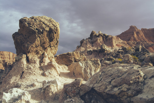
#badlands#badlands national park#the badlands#national park#national park service#national parks#landscape#landscapes#road trip#south dakota#hiking#landscape photography#travel photography#outdoor photography#nature#travel#travels#outdoors#great plains#earth pix#depth of earth#earth official#north america#geologicalwonders#geological formations#dramatic landscapes#travel blog#Badlands South Dakota#roadtrip usa
14 notes
·
View notes
Text
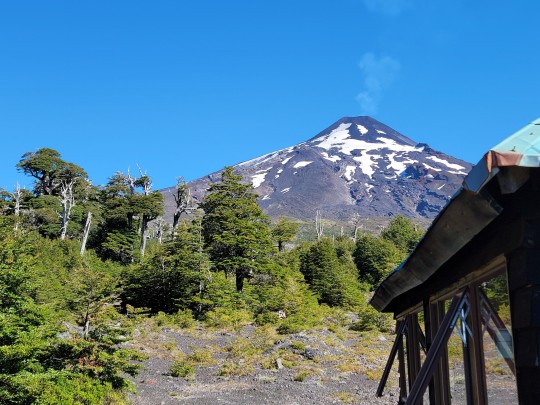


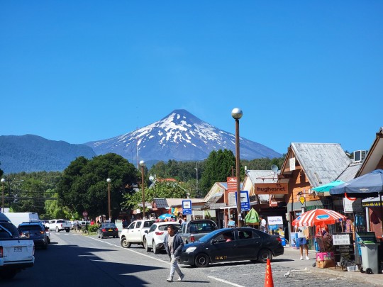
The incredible (and active!) Volcán Villarrica or Ruka Pillañ and its surroundings. Taken February 13 2024
#volcano#volcanic#volcanes#chile#travel#travel photography#pucon#villarrica#volcan villarrica#nature#geology#geologicalwonders#geological formations#ring of fire#pacific rim#volcanoes
5 notes
·
View notes
Text
Geologists initially believed the Eye of the Sahara, aka the Richat Structure, to be an enormous impact crater.
The structure is likely to have actually formed through a process called “folding”, creating what’s called a symmetrical anticline.
The sedimentary rock making up the central dome have dated the formation back to the late Proterozoic, between 1 billion and 542 million years ago.
Folding occurs when tectonic forces acting from either side squeeze sedimentary rock – if the rock is cold and brittle it can fracture, but if it’s warm enough, it will become a fold. Folds that form upwards are called an anticline, while downward folds are called a syncline.
2 notes
·
View notes
Text
Kutumsar Gupha : कुटुम्सर गुफा - छत्तीसगढ़ के अद्भुत पर्यटन स्थल रोचक बाते

कुटुम्सर गुफा(Kutumsar Gupha) - छत्तीसगढ़ के अद्भुत पर्यटन स्थल

Kutumsar Gupha : कुटुम्सर गुफा - छत्तीसगढ़ के अद्भुत पर्यटन स्थल रोचक बाते Kutumsar Gupha छत्तीसगढ़ के बस्तर जिले में स्थित है । जो छत्तीसगढ़ की राजधानी रायपुर से लगभग 283 कीमी. की दुरी पर स्थित है । यह छत्तीसगढ़ का बहुत ही लोकप्रिय पर्यटन स्थलो में एक है। जहाँ हर दीन कई सैलानी घुमने जाते है । यह छत्तीसगढ़ का प्रमुख पिकनिक स्थल में से एक है ।

छत्तीसगढ़ की सबसे लंबी गुफा यात्रा में लगने वाला समय कुटुम्सर गुफा छत्तीसगढ़ की राजधानी रायपुर से लगभग 283 कीमी. दुर बस्तर जिले में स्थित है । जहाँ पहुचने में काफी समय लगेगा । लगने वाला समय:- - मोटर सायकल में जाने पर करीब - 5 घण्टा 24 मिनट का समय लगेगा । - कार से जाने पर करीब - 5 घण्टा 28 मिनट का समय लगेगा । - पैदल चल के जाने पर करीब 2 दिन से भी ज्यादा का समय लगेगा । यह गुफा छत्तीसगढ़ राज्य के बस्तर जिले के कांकेर घाटी राष्ट्रीय उद्यान में स्थित है । यह भारत की सबसे गहरी Kutumsar Gupha गुफा मानी जाती है जो 60-120 फिट गहरी है । इसकी लम्बाई 4500 फिट है । बस्तर के इस गुफा की तुलना कल्र्सवार ऑफ़ केव से की जाती है जो कि विश्व के सबसे लम्बी गुफा है। छत्तीसगढ़ की इस गुफा प्रसिद्ध गुफा की खोज भूगाल के प्रोफेसर डा.षंकर तिवारी ने इस क्षेत्र के स्थानिय निवासियों की मद्द से किया था । इस कुटुम्सर गुफा में रंग-बिरंगी अंधी मछलीयां रहती है। जिसे भूगोल के प्रोफेसर डा.षंकर तिवारी के नाम पर कप्पी ओला षंकराई रखा गया । छत्तीसगढ़ के Kutumsar Gupha का नाम पहले गोपंसर गुफा था जिसे गोपान षब्द से लिया गया ���ै, जिसका अर्थ छिपा हुआ होता है । लेकिन वर्तमान समय में इसे कुटुम्सर गुफा के नाम से जाना जाता है । इसका यह नाम कुटुम्सर गाँव में स्थित होने के कारण पड़ा । इस गुफा की विषेशताएं लोगो के आकर्शण का केन्द्र है। कुटुम्सर गुफा की विषेशता - यह गुफा चुना पत्थर की गुफा है,यह कोलाब नदी की सहायक नदी कांगेर के किनारे में स्थित है । - यह समुद्र तल से करीब 560 मी की उचाँई पर स्थित है । - इस गुफा की मुख्य सुरंग की लम्बाई लगभग 200 मीटर है । - बारिष के मौसम में यहा पर बाढ़ आ जाती है। - इस गुफा में रंग-बिरंगी अंधी मछलीयां पाई जाती है । यह स्थान चारो ओर हरी-भरी वनस्पत्तियों , पहाडियों से घिरी हुयी है । हय गुफा बहुत ही रहस्यमयी है। कुटुम्सर गुफा जाने सबसे सही समय कुटुम्सर गुफा को आप एक सिमित समय में ही कर सकते है। प्रतिवर्श यह गुफा 1 नवम्बर से 15 जून तक जा सकतें है, लेकिन से समय को छत्तीसगढ़ पर्यटन विभाग द्वारा परिवर्तन किया जा सकता है । मानसुन के समय इस गुफा में पानी भर जाने के कारण यहा जाना संभव नही हो पाता अर्थात यह गुफा 16 जून से 30 अक्टूबर तक बन्द रहता है । इन डेटा के अनुसार आपको विन्टर के मौसम में जाना सही रहेगा । कुटुम्सर गुफा में लगने वाला शुल्क कांगेर घाटी में स्थित Kutumsar Gupha तक जाने के लिए जिप्सी का उपयोग करना पडे़गा जिसका किराया करीब 1500 भारतीय मुद्रा है। साथ ही इसी में गाइड चार्ज भी जुडा होता है । कुटुम्सर गुफा के अन्दर प्रवेष करने के लिये 25 रूपये का षुल्क देना पडता हैे।

कांगेर घाटी राष्ट्रीय उद्यान आस-पास के अन्य पर्यटन स्थल Kutumsar Gupha के आस-पास कई अन्य पर्यटन स्थल मौजूद है जहाँ इसके साथ-साथ घुमा जा सकता है। ये पर्यटन स्थल निम्न है- - कैलाष गुफा:- 30 कीमी. - कांगेर धारा:- 6 कीमी. - तीरथगढ़ जलप्र��ात:- 10 कीमी. - दंडक गुफा:- 7 कीमी. कांगेर घाटी राष्ट्रीय उद्यान में बहुत सी अच्छी जगह मौजूद हैं। जिसमें कैलाष गुफा,कांगेर धारा,तीरथगढ़ जल प्रपात,दंडक गुफा आदी । बरसात के दिनों में इस गुफा से कई छोटी-छोटी नदीया बहती है । इनके पानी में कैल्षियम उपस्थित होते हैे। साल में यह गुफा 8 माह तक घुला रहता हैे। अगर आप घुमने षौकिन हो तो छत्तीसगढ़ के इस मनोरम, सुन्दर स्थान पर एक बार जरूर जायें । यह स्थान आपके मन को हर्श-उल्लास से भर देगी । यह स्थान आपको एक नया अनुभव प्रदान करेगी । आप इस जगह से एक अच्छी यादें लेकर जा सकते हैं। Read the full article
#Adventuretourism#Bastarcaves#Caveecology#Caveexploration#Caveformations#Cavegeology#Cavenetworks#Cavesystem#Cavetourism#Cavernouslandscapes#Cavingexperience#Chhattisgarhcaves#Darkcaves#Geologicalwonders#Karstlandscape#KutumsarCave#KutumsarGupha#KutumsarGuphaजिप्सीकिराया#Naturalcaverns#Speleothems#Spelunkingdestination#Stalactiteformations#Subterraneanbeauty#Subterraneanwonders#Undergroundcaves#Undergroundrivers#कांगेरघाटी#कार#कुटुम्सरगुफा#कुटुम्सरगुफाकाशुल्क
1 note
·
View note
Photo

🌍✨ Age of Earth’s Oldest Life Forms: Stromatolites, microbial structures dating back over 3.5 billion years, are a window into the origins of life on Earth. 🦠
#EarthHistory#Stromatolites#GeologicalWonders#OldestLifeForms#ScienceFacts#DidYouKnow#Evolution#MicrobialMats#AncientLife#STEMTrivia
1 note
·
View note
Text

Interesting fact #1
#MarianaTrench#ChallengerDeep#DeepOcean#OceanExploration#UnderwaterWorld#MarineBiology#ExtremeDepths#PacificOcean#OceanConservation#GeologicalWonders
1 note
·
View note
Text
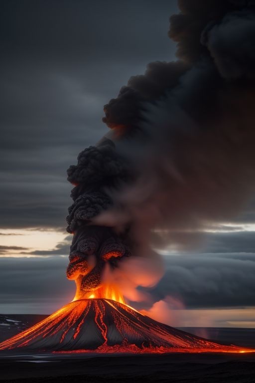
Witnessing Nature's Fury: Iceland Volcano Spews Lava in Eruption
Iceland, a land of stunning landscapes and geological wonders, has once again captured the world's attention with a spectacular display of nature's power. In recent days, a volcano in the Reykjanes Peninsula has erupted, sending plumes of ash and rivers of molten lava into the air. This event, while not unexpected in a country known for its volcanic activity, has mesmerized onlookers and sparked discussions about the dynamic forces shaping our planet. In this blog post, we delve into the eruption, its causes, and its significance.
On a chilly morning in Iceland, residents and visitors awoke to the rumblings of Fagradalsfjall, a volcano located approximately 30 kilometers southwest of the capital, Reykjavik. This awakening marked the first eruption in the area in over 800 years, igniting excitement and awe among those fortunate enough to witness it firsthand. The eruption initially began with a fissure opening on the volcano's slopes, unleashing a cascade of fiery lava that flowed gracefully down the mountainside.
As the eruption progressed, lava fountains illuminated the night sky, casting an otherworldly glow over the surrounding landscape. The lava, a molten testament to the Earth's inner turmoil, flowed steadily, carving new channels and reshaping the terrain with each passing hour. Spectators gathered from near and far, cameras in hand, to capture the spectacle and bear witness to the raw power of nature in motion.
The eruption of Fagradalsfjall, like many volcanic events, is rooted in the complex geological processes that shape the planet's surface. Iceland sits atop the Mid-Atlantic Ridge, a boundary where the Eurasian and North American tectonic plates meet and diverge. This geological hotspot is responsible for Iceland's volcanic activity, as magma from the Earth's mantle rises to the surface, creating new landmasses and reshaping the island over millennia.
In the case of the Fagradalsfjall eruption, experts believe that a combination of factors, including magma pressure and tectonic stress, contributed to the volcano's awakening. While volcanic activity in Iceland is not uncommon, the precise timing and location of eruptions remain unpredictable, underscoring the dynamic nature of the planet we call home.
Beyond its awe-inspiring beauty, the eruption of Fagradalsfjall holds scientific significance and offers valuable insights into the inner workings of our planet. Volcanic eruptions provide scientists with opportunities to study magma dynamics, gas emissions, and the interactions between geological processes and the environment. By monitoring and analyzing volcanic activity, researchers can better understand volcanic hazards and mitigate risks to human populations living in volcanic regions.
Furthermore, the eruption serves as a reminder of Iceland's geological heritage and its unique place in the natural world. For centuries, Icelanders have coexisted with volcanic activity, harnessing its energy for geothermal power and drawing inspiration from its rugged landscapes. The eruption of Fagradalsfjall serves as a testament to the resilience of both nature and humanity, highlighting our ability to adapt and thrive in the face of adversity.
The eruption of Fagradalsfjall stands as a testament to the awe-inspiring power of nature and the dynamic forces that shape our planet. From its humble beginnings as a fissure in the earth to its fiery crescendo of lava fountains and ash plumes, the eruption captivated the world and reminded us of the fragile balance between creation and destruction. As Icelanders and visitors alike gather to witness this geological spectacle, let us marvel at the wonders of the natural world and strive to protect and preserve the beauty that surrounds us.
1 note
·
View note
Text
Rainbow Mountains of China's Zhangye Danxia National Geologic Park

Unleash your inner child and wander through nature's playful masterpiece - the Rainbow Mountains of China.
0 notes
Text
Liesegang Rings at Bouddi National Park, New South Wales, Australia /

Step into tranquility and be captivated by the mesmerizing Liesegang Rings at Bouddi National Park. Marvel at this unique geological phenomenon found in the heart of New South Wales, Australia.
0 notes
Text
Rainbow Mountains of China's Zhangye Danxia National Geologic Park

Prepare to be dazzled by the kaleidoscope of colors at the mesmerizing Zhangye Danxia National Geologic Park. It's like stepping into a real-life Pinterest board.
0 notes
Text


The beginnings of Life on 🌍 never cease to amaze me.
0 notes
Text
columnar basalt on the icelandic coast

Explore the hidden wonders of Iceland's coastal landscape, where intricate columnar basalt formations stand as a testament to the earth's artistic prowess.
0 notes
Link
#Grootfontain#Namibia#HobaMeteorite#HistoricalSignificance#NaturalBeauty#OldGermanFort#ColonialHistory#NamibianLandmarks#WaterbergPlateauPark#Wildlife#NamibianCountryside#GeologicalWonders#TouristAttractions#AfricanTravel#HobaMeteoriteSite#HistoricalLandmarks#NamibianHeritage#NatureExploration#TravelNamibia#AfricanLandscapes#CulturalHistory#TourismNamibia#LandmarkSightseeing#HobaMeteoriteVisit#HistoricalSites#NaturalWonders#NamibianAdventure#TravelDestinations#AfricanGeology#ScenicBeauty.
0 notes
Photo

Ancient limestone formations inside Lake Shasta Caverns, California Unleash your inner explorer and witness the magnificent ancient limestone formations hidden within the depths of Lake Shasta Caverns, California. It's a captivating journey through history.
0 notes
Text
Living in the Paleozoic Era 🌿🦕🌏
Welcome to a journey back in time to the Paleozoic Era, a period of Earth's history that spans from about 541 million to 252 million years ago. It's a time of ancient landscapes, bizarre creatures, and dramatic geological changes. Let's dive into what life was like during this fascinating era!
🌍 Ancient Supercontinents: During the Paleozoic Era, Earth looked quite different from what we know today. The landmasses were joined together in the supercontinent Pangaea, surrounded by a vast Panthalassa Ocean.
🌋 Volcanic Activity: Volcanoes were a common sight, and they released massive amounts of greenhouse gases, creating a warm, tropical climate. Sea levels were much higher, with shallow seas covering large portions of the continents.
🌿 The Dawn of Life: Life was thriving, but it was vastly different from the species we see today. The first land plants appeared, bringing greenery to the barren landscapes. These early plants laid the foundation for terrestrial ecosystems.
🐚 Marine Wonders: The oceans were teeming with life. Ancient creatures like trilobites, nautiloids, and jawless fish ruled the seas. Corals began building reefs, while the first fish with jaws emerged.
🦗 Invasion of Land: One of the most significant events of the Paleozoic was the colonization of land. Arthropods, like millipedes and scorpions, were among the first to venture onto the continents. They were soon followed by amphibians.
🌅 Mass Extinctions: The era was marked by multiple mass extinctions, including the Ordovician-Silurian and Permian-Triassic extinctions. These events shaped the course of life on Earth and paved the way for new species to evolve.
🦕 The Age of Reptiles: By the late Paleozoic, reptiles had emerged, including the iconic sail-backed Dimetrodon. These reptiles were the ancestors of the dinosaurs that would dominate the next era.
🌄 The End of an Era: The Paleozoic Era came to a close with the Permian-Triassic extinction, the most devastating in Earth's history. It wiped out nearly 95% of marine species and marked the end of many Paleozoic life forms.
Today, we marvel at the remnants of the Paleozoic Era, from the fossils of trilobites to the geological formations that tell the story of this ancient world. Studying this era helps us understand the evolution of life on Earth and the forces that have shaped our planet.
#PaleozoicEra#AncientEarth#LifeOnLand#MassExtinctions#PrehistoricCreatures#GeologicalHistory#FossilHunting#EvolutionaryTimeline#DawnOfLife#ReptilianWorld#Paleontology#AncientLandscapes#GeologicalWonders#EarthHistory#SailBackedReptiles#Pangaea#PrehistoricPlants#AncientOceans#TriassicEra#PermianExtinction#Trilobites#Amphibians#VolcanicActivity#PanthalassaOcean#Arthropods#FossilRecord#PrehistoricClimate
0 notes
Text
Liesegang Rings at Bouddi National Park, New South Wales, Australia /

Step into tranquility and be captivated by the mesmerizing Liesegang Rings at Bouddi National Park. Marvel at this unique geological phenomenon found in the heart of New South Wales, Australia.
0 notes