#MappingTechnology
Explore tagged Tumblr posts
Visit Tumblr Blog
Explore Tumblr blogs with no restrictions, modern design and the best experience.
Last Seen Tumblr Blogs


Fun Fact
Tumblr is available in 18 languages.
Text

Discover how drone survey enhance mapping, accuracy, and efficiency. Learn about costs, benefits, and choosing the right drone surveying company today!
0 notes
Text
Temperature mapping services of Ovens
inquiry : https://vegabazaar.com/.../Temperature-mapping-services.../
0 notes
Text
Ola Maps reliability issues according to MapmyIndia CEO

Rohan Verma, CEO of MapmyIndia, has criticized ANI Technologies, the parent company of Ola, for what he describes as “gimmick” promises related to their navigational maps of India. Verma questioned the credibility of Ola’s map service, which allegedly involves a startup named Geospoc Pvt Ltd, after receiving a legal notice from Ola Electric.
Verma expressed skepticism about the quality of Ola’s maps, stating that he does not view them as a business threat because they lack sufficient quality. This skepticism is echoed by numerous users who have complained about the poor performance of Ola’s revamped taxi and electric vehicle apps. Despite the promotional claims, the actual product has been widely criticized for its subpar map quality.
This dispute follows a licensing agreement signed on July 23, 2021, between Ola Electric and MapmyIndia. The deal allowed Ola to use MapmyIndia’s APIs and SDKs. MapmyIndia alleges that Ola breached the terms of this agreement. In response, Ola has strongly denied these accusations, suggesting that they are an attempt by MapmyIndia to undermine their competition.
Verma emphasized that map development is a complex and resource-intensive process that requires significant expertise and investment. He noted that only a few companies have succeeded in this field internationally, and it is implausible for a company to suddenly produce high-quality maps without a solid track record. Verma also cautioned against relying on competing map services, urging consumers to be wary of products that might lack accuracy and reliability.
READ MORE
#MapmyIndia#OlaMaps#MapmyIndiaCEO#OlaMapsCriticism#IndianTech#NavigationApps#TechWarnings#IndianTechNews#MappingTechnology#OlaMapsGimmick#MapmyIndiaVsOla#TechOpinions#NavigationWarnings#TechIndustryInsights#MappingCritique
0 notes
Text
Elevate Your Aerial Operations with DJI Matrice 350 RTK | AeroSmart.ae
Welcome to AeroSmart.ae, your gateway to advanced aerial solutions. As we celebrate our 1-year milestone, we're excited to introduce you to the DJI Matrice 350 RTK, a game-changer in the world of unmanned aerial vehicles (UAVs).
DJI Matrice 350 RTK: Redefining Precision in Aerial Operations
Unparalleled Precision
The DJI Matrice 350 RTK is engineered for precision, equipped with Real-Time Kinematic (RTK) technology that ensures centimeter-level accuracy in positioning. Whether you're in surveying, mapping, or inspection, experience unparalleled precision in every flight.
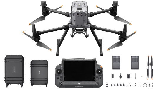
Advanced Flight Control
Navigate the skies with confidence using the Matrice 350's advanced flight control system. Its intelligent features, such as obstacle avoidance and automated flight paths, make your operations smoother and safer. Focus on your mission while the Matrice 350 takes care of the details.
Versatile Payload Options
Tailor your drone to meet your specific needs with the Matrice 350's versatile payload options. Capture high-resolution images, perform thermal inspections, or carry out surveys with ease. This drone adapts to your requirements, ensuring you have the right tool for the job.
Long-Lasting Performance
Built for endurance, the Matrice 350 RTK boasts an impressive flight time, allowing you to cover more ground in a single mission. Maximize your productivity and minimize downtime with a UAV that's designed to go the distance.
AeroSmart.ae: Your Partner in Aerial Excellence
At AeroSmart.ae, we're committed to providing you with cutting-edge technology that empowers your aerial operations. Our 1-year journey has been marked by dedication to excellence and customer satisfaction.
Explore the DJI Matrice 350 RTK on our website and discover how it can transform the way you approach aerial tasks. Elevate your operations with AeroSmart.ae where innovation meets reliability in the skies.
Contact Us today and let our experts guide you in choosing the perfect UAV solution for your needs. Your success is our priority.
Source:- https://aerosmart84.blogspot.com/2023/11/elevate-your-aerial-operations-with-dji.html
#AeroSmart#DroneTech#PrecisionAerial#Matrice350RTK#UAVInnovation#AerialSolutions#DJI#AeroTech#SkyHighPrecision#AerialExcellence#FlightInnovation#DroneLife#AeroSmartAnniversary#SkywardAdvancements#MappingTechnology#RTKPrecision#AeroSmart1Year#ExploreTheSkies#DroneCapabilities#AerialOperations
0 notes
Text
AI & Self-Driving Cars: A $25.8B Industry by 2034 – The Future is Now!
AI in Autonomous Vehicle Sensors Market is accelerating towards a smarter, safer future, integrating AI-driven LiDAR, radar, and camera systems to enhance vehicle perception and decision-making. These cutting-edge sensors enable autonomous vehicles to navigate complex environments, ensuring efficiency and safety while reducing accidents and optimizing traffic flow. 🚦
To Request Sample Report : https://www.globalinsightservices.com/request-sample/?id=GIS33019 &utm_source=SnehaPatil&utm_medium=Article
🔍 Market Overview LiDAR leads the market, offering unmatched accuracy in environmental mapping and obstacle detection. Camera sensors follow closely, benefiting from advancements in AI-driven image processing. Radar sensors, while slightly behind, are gaining traction due to their reliability in adverse weather conditions.
🌎 Regional Insights
North America dominates, driven by massive investments and technological innovation in autonomous vehicle development.
Europe ranks second, benefiting from stringent safety regulations and a strong automotive industry.
Key players: The United States and Germany spearhead advancements, fostering strategic partnerships to enhance sensor accuracy and AI integration.
📊 Market Segmentation & Key Trends
Type: LiDAR, Radar, Ultrasonic, Camera, Infrared Sensors
Application: Passenger Vehicles, Commercial Vehicles, Ride-Sharing, Logistics
Technology: Machine Learning, Deep Learning, Computer Vision, Sensor Fusion
Functionality: Perception, Localization, Mapping, Decision-Making
Deployment: Cloud-Based, Edge-Based, Hybrid
🚀 Future Outlook The LiDAR segment dominates, while camera-based sensors hold 30% of the market, followed by radar sensors at 25%. Major players like Velodyne Lidar & Luminar Technologies are driving innovation, while regulatory frameworks in the US & EU shape safety standards. 🚘 Despite high production costs, increased R&D investments and AI integration will fuel growth, making autonomous driving a reality!
#autonomousvehicles #aiinsensors #lidartechnology #radarsensors #camerasensors #sensorfusion #driverlesscars #futureofmobility #smarttransportation #aiinmobility #deeptech #machinelearning #computervision #automotiveinnovation #robotaxis #selfdrivingcars #nextgentech #avtechnology #smartcities #connectedcars #automateddriving #aiintheautomotiveindustry #techforgood #vehicletechnology #innovationdriven #ridesharing #logisticsautomation #autonomousfleets #smartmobilitysolutions #evfuture #mobilitydisruption #automotivesensors #mappingtechnology #cloudcomputing #aiinlogistics #edgecomputing
Research Scope:
· Estimates and forecast the overall market size for the total market, across type, application, and region
· Detailed information and key takeaways on qualitative and quantitative trends, dynamics, business framework, competitive landscape, and company profiling
· Identify factors influencing market growth and challenges, opportunities, drivers, and restraints
· Identify factors that could limit company participation in identified international markets to help properly calibrate market share expectations and growth rates
· Trace and evaluate key development strategies like acquisitions, product launches, mergers, collaborations, business expansions, agreements, partnerships, and R&D activities
About Us:
Global Insight Services (GIS) is a leading multi-industry market research firm headquartered in Delaware, US. We are committed to providing our clients with highest quality data, analysis, and tools to meet all their market research needs. With GIS, you can be assured of the quality of the deliverables, robust & transparent research methodology, and superior service.
Contact Us:
Global Insight Services LLC 16192, Coastal Highway, Lewes DE 19958 E-mail: [email protected] Phone: +1–833–761–1700 Website: https://www.globalinsightservices.com/
0 notes
Link
Check out this listing I just added to my Poshmark closet: Fabletics Luciana Rib Seamless Long-Sleeve Zip Up.
0 notes
Text
Faultlines, black holes and glaciers: mapping uncharted territories
Full post over on tuthillscopes.com
Faultlines, black holes and glaciers: mapping uncharted territories
The Lengthy Read: Within the era of satellites and Google Maps you may still find areas that remain a mysterious On a basic summer time evening, the Aurora, a 60ft cutter-rigged sloop, approaches the rugged shore of eastern Greenland, along what is known the Forbidden Coast. Its captain,...
#Geography, #Greenland, #MappingTechnologies, #Maps, #Science, #Technology, #WorldNews
0 notes
Text
Faultlines, black holes and glaciers: mapping uncharted territories
more on tuthillscopes.com
Faultlines, black holes and glaciers: mapping uncharted territories
The Lengthy Read: Within the era of satellites and Google Maps you may still find areas that remain a mysterious On a basic summer time evening, the Aurora, a 60ft cutter-rigged sloop, approaches the rugged shore of eastern Greenland, along what is known the Forbidden Coast. Its captain,...
#Geography, #Greenland, #MappingTechnologies, #Maps, #Science, #Technology, #WorldNews
0 notes
Text
Temperature and humidity mapping of Cold Storage Areas services Ensure the integrity of your cold storage areas with our expert Temperature and Humidity Mapping services, tailored to meet the stringent requirements of industries such as pharmaceuticals, biotechnology, and food storage. Our comprehensive solution utilizes cutting-edge technology to meticulously assess and document temperature and humidity variations within your storage environment. inquiry : https://vegabazaar.com/product/Temperature-and-humidity-mapping-of-Cold-Storage-Areas-services/
0 notes
Text

Temperature mapping services of Deep freezer room
inquiry : https://vegabazaar.com/.../Temperature-mapping-services.../
0 notes
Link
Check out this listing I just added to my Poshmark closet: Fabletics Luciana Rib Seamless Long-Sleeve Zip Up.
0 notes