#WDEF Weather
Text
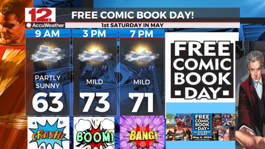
@WDEFNews12 - #FreeComicBookDay 2024 won't be a dry one with showers and thunderstorms possible, but being in a comic book store on a rainy day sounds like a great time to me! #SupportYourLocalComicBookStore
#Free Comic Book Day#WDEF Weather#wdef news 12#wdef-tv#chattanooga weather#wdef.com/weather#wdef#chief meteorologist austen onek#tennessee river valley#[email protected]#wdef chattanooga#wdef.com
0 notes
Text
#WDEFWeather #News12Weather #BlipCast for Thursday evening: increasing clouds this evening, better chances for some showers into early Friday.
Your week-ending forecast coming up tonight on @WDEFNews12 at 5:30, 6, 7 & 11. Can't join us on-air? Go to wdef.com/weather.
#wdef.com/weather#chief meteorologist austen onek#[email protected]#chattanooga weather#wdef chattanooga#wdef-tv#tennessee river valley#wdef news 12#wdef.com#wdef#WDEF Weather#News 12 Weather
0 notes
Text
WDEFWeather #News12Weather #BlipCast: quiet, dry and warm Thursday almost in the books. Could be a stormy Friday for parts of the area. We'll time out the potential for severe weather coming up on @WDEFNews12 at 5:30, 6, 7 & 11.
#wdef.com/weather#chief meteorologist austen onek#tennessee river valley#[email protected]#wdef chattanooga#chattanooga weather#wdef.com#wdef#wdef-tv#wdef news 12#WDEF Weather#WDEF BlipCast Forecast
0 notes
Text
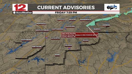
For SE Monroe County TN in the WDEF News 12 viewing area…
…HIGH WIND WARNING IN EFFECT FROM MIDNIGHT TONIGHT TO
10 AM EST SATURDAY…
WHAT…Southeast winds 25 to 35 mph with gusts up to 65 mph
expected.
WHERE…The higher elevations and foothills of the East
Tennessee mountains.
IMPACTS…Damaging winds will blow down trees and power lines.
Widespread power outages are expected.
Travel will be difficult, especially for high profile vehicles.
#wdef weather#wdef news 12#wdef chattanooga#wdef.com#chattanooga weather#tennessee river valley#wdef.com/weather#wdef-tv#wdef
0 notes
Text
#WDEFWeather #BlipCast for Wednesday Evening: Some clouds but dry for mid-week. Cooler weather on the way as we close out 2023.
More on your forecast tonight on WDEF News 12 at 5:30, 6, 7 & 11. Can't join us on air? Go to wdef.com/weather for updates.
0 notes
Text
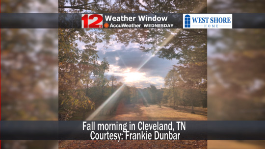
Many thanks to #WDEFNews12 viewer Frankie Dunbar for an early morning autumn view from #ClevelandTN - our @WestShoreHome #WeatherWindow #PictureOfTheDay.
#WDEF#WDEF-TV#WDEF.com#WDEF News 12#News 12 Chattanooga#WDEF Chattanooga#WDEF-TV News 12#Tennessee River Valley#wdef.com/weather#Chief Meteorologist Austen Onek#[email protected]#Chattanooga Weather#WDEF Weather#Weather In Chattanooga#West Shore Home#Weather Window#Picture Of The Day
0 notes
Text
ICYMI: Here's the latest detailed look at your #WDEFNews12 forecast. #ThisIsThePlace for #WeatherOvertime. #ShareAndEnjoy
youtube
#WDEF#WDEF-TV#WDEF.com#WDEF News 12#News 12 Chattanooga#WDEF Chattanooga#WDEF-TV News 12#Tennessee River Valley#wdef.com/weather#Chief Meteorologist Austen Onek#[email protected]#Chattanooga Weather#WDEF Weather#Weather In Chattanooga#West Shore Home#Weather Window#Picture Of The Day#WDEF Weather Overtime#WDEF weatherblog#WDEF News 12 Weatherblog#Island Cove Marina And Resort#Food City#Weather In The Classroom#epb fiber optics#Weather Where The Troops Are#Chattanooga Tennessee Weatherblog#Paniagua Auto Mall#Weather Question of the Day#Skywarn#Skywarn storm spotter
0 notes
Text
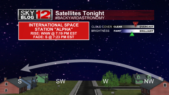
#WDEFWeather #SkyBlog12 #BackyardAstronomy --- The International Space Station will pass over the @wdefnews12 viewing area, remaining very low in the western skies. Clouds won't be a major problem but could interfere along the flight path. #KeepLookingUp
#AmateurAstronomy#ScienceRules#KeepLookingUp#SkyBlog12#WDEF#WDEF-TV#WDEF.com#WDEF News 12#News 12 Chattanooga#WDEF Chattanooga#WDEF-TV News 12#Tennessee River Valley#wdef.com/weather#Chief Meteorologist Austen Onek#[email protected]#Chattanooga Weather#WDEF Weather#Weather In Chattanooga
0 notes
Text
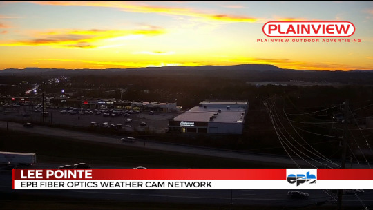
Wednesday #sunset light from Lee Pointe on the Plainview Outdoor Advertising camera looking off towards #LookoutMountain in the distance.
#WDEF#WDEF-TV#WDEF.com#WDEF News 12#News 12 Chattanooga#WDEF Chattanooga#WDEF-TV News 12#Tennessee River Valley#wdef.com/weather#Chief Meteorologist Austen Onek#[email protected]#Chattanooga Weather#WDEF Weather#Weather In Chattanooga
0 notes
Text
#WDEFWeather #BlipCast for Wednesday Evening: Dry until the end of the week, when chances for rain and thunderstorms increase. Tune in tonight for your updated forecast coming up on @WDEFNews12 at 5:30, 6, 7 & 11.
#WDEF#WDEF-TV#WDEF.com#WDEF News 12#News 12 Chattanooga#WDEF Chattanooga#WDEF-TV News 12#Tennessee River Valley#wdef.com/weather#Chief Meteorologist Austen Onek#[email protected]#Chattanooga Weather#WDEF Weather#Weather In Chattanooga
0 notes
Text
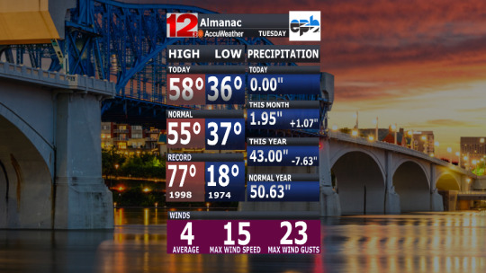
#WDEFWeather #WeatherAlmanac for Tuesday, December 5, 2023
#WDEF#WDEF-TV#WDEF.com#WDEF News 12#News 12 Chattanooga#WDEF Chattanooga#WDEF-TV News 12#Tennessee River Valley#wdef.com/weather#Chief Meteorologist Austen Onek#[email protected]#Chattanooga Weather#WDEF Weather#Weather In Chattanooga
0 notes
Text
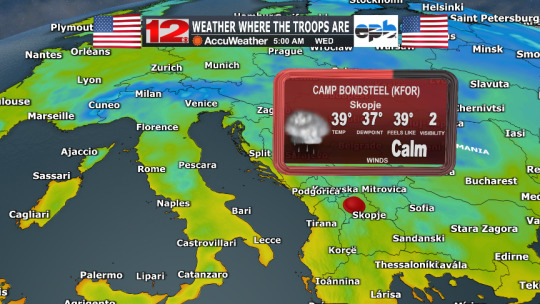
Not everyone can get #HomeForTheHolidays as they are serving our country in faraway places. Keeping you on the homefront informed with our WDEF News 12 #WeatherWhereTheTroopsAre updates through year's end.
#WDEF#WDEF-TV#WDEF.com#WDEF News 12#News 12 Chattanooga#WDEF Chattanooga#WDEF-TV News 12#Tennessee River Valley#wdef.com/weather#Chief Meteorologist Austen Onek#[email protected]#Chattanooga Weather#WDEF Weather#Weather In Chattanooga#Weather Where The Troops Are
0 notes
Text
#WDEFNews12 #weatherblog #WeatherOvertime. #ShareAndEnjoy Tuesday December 5, 2023
ICYMI: After a brief drop in temperatures Wednesday, mild weather for the rest of the week. Then more chances for rain/thunder by the upcoming weekend.
All that and much more in tonight's #WDEFNews12 #weatherblog #WeatherOvertime. #ShareAndEnjoy
youtube
#WDEF#WDEF-TV#WDEF.com#WDEF News 12#News 12 Chattanooga#WDEF Chattanooga#WDEF-TV News 12#Tennessee River Valley#wdef.com/weather#Chief Meteorologist Austen Onek#[email protected]#Chattanooga Weather#WDEF Weather#Weather In Chattanooga#West Shore Home#Weather Window#Picture Of The Day#WDEF Weather Overtime#WDEF weatherblog#WDEF News 12 Weatherblog#Island Cove Marina And Resort#Food City#Weather In The Classroom#epb fiber optics#Weather Where The Troops Are#Chattanooga Tennessee Weatherblog#Paniagua Auto Mall#Weather Question of the Day#Skywarn#Skywarn storm spotter
0 notes
Text
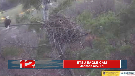
#WDEFWeather: #BaldEagle on the @etsu #EagleCam at sunset Tuesday.
0 notes
Text
WDEFWeather #BlipCast for Tuesday Evening: our next cold front is almost here which will give us a windy and chilly Wednesday. Indoor plans for the weekend would be a good idea. More on your complete forecast tonight on #WDEFNews12 at 5:30, 6, 7 & 11.
#WDEF#WDEF-TV#WDEF.com#WDEF News 12#News 12 Chattanooga#WDEF Chattanooga#WDEF-TV News 12#Tennessee River Valley#wdef.com/weather#Chief Meteorologist Austen Onek#[email protected]#Chattanooga Weather#WDEF Weather#Weather In Chattanooga
0 notes
Text
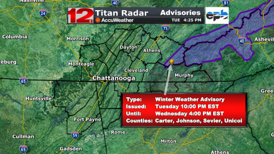
For SE Monroe County TN in the #WDEFNews12 viewing area.
WINTERWEATHERADVISORY REMAINS IN EFFECT FROM 10 PM THIS EVENING TO 4 PM EST WEDNESDAY…
WHAT…Snow expected. Total snow accumulations of 1-3" above 2500 ft, with greater than 3" possible above 4000 ft.
WHERE…Mountains of East Tennessee, mainly above 2500 ft.
WHEN…From 10 PM this evening to 4 PM EST Wednesday.
IMPACTS…Plan on slippery road conditions. The hazardous
conditions could impact the morning commute, especially if
traveling over the Appalachian Mountains.
0 notes
Last Seen Blogs

wasted-women
Trope of the blog: Women in refrigerators


rainbow-meme-trash
[bea]

rhetttsai
#RhetttsaiInHisMidwesternNightsDream

chickpeamag
chickpea mag