#eastern Sierra Observatory
Text

A vista view of the Eastern Sierra range from Bristlecone Pine Forest in the White Mountains.
This was a quick (2 night) trip to the Eastern Sierra Observatory near Bishop. It was a lot of driving, but we had some unique and interesting experiences, like looking at stars and meteors, and hiking through the oldest trees on the planet.
1 note
·
View note
Photo
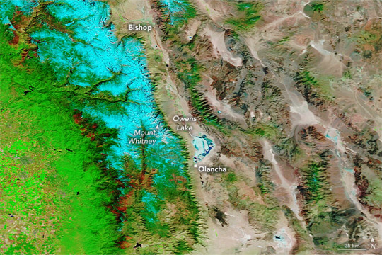
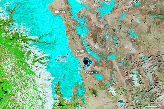
A Surge of Floodwater For Owens Lake California's Owens Lake has been mostly dry since the construction of the Los Angeles Aqueduct in 1913. The project siphoned water from the eastern slopes of the Sierra Nevada range and Owens River Valley to the city of Los Angeles, 220 miles (354 kilometers) to the south, drawing down the lake. That changed in March 2023 after floodwaters pooled on the west side of the aqueduct, eroded soil that supported the concrete-lined channel, and contributed to the collapse of three of its sections near Olancha. To drain and repair the damaged section of the aqueduct, the Los Angeles Department of Water and Power (LADWP) opened spill gates letting water run downstream. According to news reports, some of that floodwater joined with water from other sources and poured over the lakebed of Owens Lake. Two weeks later, on March 25, the Moderate Resolution Imaging Spectroradiometer (MODIS) on NASA’s Terra satellite acquired this image (lower image) of Owens Lake. The image is false color, which makes the water (dark blue) stand out from its surroundings. Snow appears light blue and vegetation is green. The image on the left shows the same area in March 2022. This is the first time the Los Angeles Aqueduct has been breached by extreme weather, according to the Los Angeles Times. But it is not the first time the lakebed has flooded since the construction of the aqueduct. Since the early 2000s, LADWP has occasionally flooded parts of the lake with shallow water to prevent dust from becoming airborne and potentially affecting human health. However, the aqueduct’s breach came after an atmospheric river brought 5 to 13 inches of rain to parts of Central California on March 9 and 10. Heavy precipitation in the state in 2023 led to a record amount of snow on the southern Sierra Nevada range (shown in light blue in the image above). Yet, the past three years have been some of California’s driest. Recent research indicates that climate change has made these water cycle extremes more common. Matthew Rodell, a hydrologist based at NASA’s Goddard Space Flight Center, led a recent study that used data from the NASA/German Gravity Recovery and Climate Experiment (GRACE) and GRACE Follow-On (GRACE-FO) satellites to characterize extreme wet and dry events over the past 20 years. GRACE satellites monitor miniscule, month-to-month changes in Earth’s gravity field that scientists can use to determine where on Earth water is accumulating or diminishing. The researchers ranked 1,056 extreme events during the two-decade period and found that the most intense droughts and wet events were becoming more frequent. During the first 13 years of the study, there was an average of three major extreme wet or dry events per year. Yet between 2015 and 2021, seven of the planet’s 10 warmest years, there was an average of four such extreme events per year. According to Rodell: “What we’re seeing in California—this weather whiplash between extreme dry and wet conditions—is becoming more common as a result of climate change.” NASA Earth Observatory images by Lauren Dauphin, using MODIS data from NASA EOSDIS LANCE and GIBS/Worldview. Story by Emily Cassidy.
2 notes
·
View notes
Text
Events 3.13
624 – The Battle of Badr, the first major battle between the Muslims and Quraysh.
1567 – The Battle of Oosterweel, traditionally regarded as the start of the Eighty Years' War.
1591 – At the Battle of Tondibi in Mali, Moroccan forces of the Saadi dynasty, led by Judar Pasha, defeat the Songhai Empire, despite being outnumbered by at least five to one.
1639 – Harvard College is named after clergyman John Harvard.
1697 – Nojpetén, capital of the last independent Maya kingdom, falls to Spanish conquistadors, the final step in the Spanish conquest of Guatemala.
1741 – The Battle of Cartagena de Indias (part of the War of Jenkins' Ear) begins.
1781 – William Herschel discovers Uranus.
1809 – Gustav IV Adolf of Sweden is deposed in the Coup of 1809.
1811 – A French and Italian fleet is defeated by a British squadron off the island of Vis in the Adriatic during the Napoleonic Wars.
1826 – Pope Leo XII publishes the apostolic constitution Quo Graviora in which he renewed the prohibition on Catholics joining freemasonry.
1845 – Felix Mendelssohn's Violin Concerto receives its première performance in Leipzig with Ferdinand David as soloist.
1848 – The German revolutions of 1848–1849 begin in Vienna.
1862 – The Act Prohibiting the Return of Slaves is passed by the United States Congress, effectively annulling the Fugitive Slave Act of 1850 and setting the stage for the Emancipation Proclamation.
1884 – The Siege of Khartoum begins. It lasts until January 26, 1885.
1888 – The eruption of Ritter Island triggers tsunamis that kill up to 3,000 people on nearby islands.
1900 – British forces occupy Bloemfontein, Orange Free State, during the Second Boer War.
1920 – The Kapp Putsch briefly ousts the Weimar Republic government from Berlin.
1930 – The news of the discovery of Pluto is announced by Lowell Observatory.
1940 – The Winter War between Finland and the Soviet Union officially ends after the signing of the Moscow Peace Treaty.
1943 – The Holocaust: German forces liquidate the Jewish ghetto in Kraków.
1954 – The Battle of Điện Biên Phủ begins with an artillery barrage by Viet Minh forces under Võ Nguyên Giáp; Viet Minh victory led to the end of the First Indochina War and French withdrawal from Vietnam.
1957 – Cuban student revolutionaries storm the presidential palace in Havana in a failed attempt on the life of President Fulgencio Batista.
1969 – Apollo 9 returns safely to Earth after testing the Lunar Module.
1974 – Sierra Pacific Airlines Flight 802 crashes into the White Mountains near Bishop, California, killing 36.
1979 – The New Jewel Movement, headed by Maurice Bishop, ousts the Prime Minister of Grenada, Eric Gairy, in a coup d'état.
1988 – The Seikan Tunnel, the longest tunnel in the world with an undersea segment, opens between Aomori and Hakodate, Japan.
1992 – The Mw 6.6 Erzincan earthquake strikes eastern Turkey with a maximum Mercalli intensity of VIII (Severe).
1993 – The 1993 Storm of the Century affects the eastern United States, dropping feet of snow in many areas.
1996 – The Dunblane massacre leads to the death of sixteen primary school children and one teacher in Dunblane, Scotland.
1997 – The Missionaries of Charity choose Sister Nirmala to succeed Mother Teresa as their leader.
2003 – An article in Nature identifies the Ciampate del Diavolo as 350,000-year-old hominid footprints.
2012 – The Sierre coach crash kills 28 people, including 22 children.
2013 – The 2013 papal conclave elects Cardinal Jorge Mario Bergoglio taking the name Pope Francis as the 266th Pope of the Catholic Church.
2016 – The Ankara bombing kills at least 37 people.
2016 – Three gunmen attack two hotels in the Ivory Coast town of Grand-Bassam, killing at least 19 people.
2020 – President Donald Trump declares the COVID-19 pandemic to be a national emergency in the United States.
2020 – Breonna Taylor is killed by police officers who were forcibly entering her home in Louisville, Kentucky; her death sparked extensive protests against racism and police brutality.
0 notes
Text
Something Sciency, Cool, & Interesting: The Series
Episode 1: Diamonds being made from the Carbon in the Air
Links:
https://www.theguardian.com/environment/2020/oct/30/ecotricity-founder-to-grow-diamonds-made-entirely-from-the-sky#:~:text=Dale%20Vince%2C%20the%20founder%20of,sky%20mining%20facility%E2%80%9D%20in%20Stroud.
https://news.sky.com/story/eco-friendly-diamonds-developed-using-carbon-sucked-from-the-air-bling-without-the-sting-12118523
SUMMARISED
I absolutely love this! Whilst I am not the biggest fan of gemstones, I do know many people who are, and this is such a wonderful way to make these wonderful gems at a lower impact to environment!
The diamonds are certified by the International Gemological Institute, meaning they are pretty much chemically and physically identical to the real ones.
Not only does this allow people to continue buying diamonds in a way that is completely sustainable (it actually has a negative carbon impact because the carbon from the air is now being locked into a very permanent form), but it will most likely make them faster to produce and cheaper to buy.
Currently, the diamond mining industry causes incredible ecological devastation, from rerouting rivers to causing soil erosion. From this link: https://www.brilliantearth.com/blood-diamond-environmental-impact/ - “Diamond miners in the Kono district of eastern Sierra Leone have left behind thousands of abandoned mining pits. Wildlife has vanished, topsoil has eroded, and land once suitable for farming is now a desolate moonscape. The mining pits have created a public health disaster as well. When the pits fill with stagnant rainwater, they become infested with mosquitoes, spreading malaria and other water-borne diseases.” This is an excellent example of the negative impact of diamond mining.
Also, the concentration of carbon dioxide in the atmosphere is now at 412 parts per million! That could be used to make a lot of diamonds.
https://climate.nasa.gov/news/2915/the-atmosphere-getting-a-handle-on-carbon-dioxide/#:~:text=The%20concentration%20of%20carbon%20dioxide,it%20was%20near%20370%20ppm.
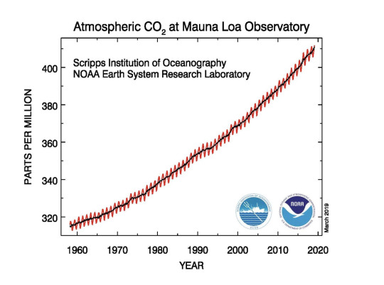
This graph illustrates the steadily increasing concentrations of carbon dioxide in the atmosphere (in parts per million) observed at NOAA's Mauna Loa Observatory in Hawaii over the course of 60 years. Measurements of the greenhouse gas began in 1959.
5 notes
·
View notes
Text

Meade's 14" LX850 at Eastern Sierra Observatory in Bishop, CA.
1 note
·
View note
Text
Present Time Gmt

What Countries Are In Gmt
Present Time Tense
Gmt Time Zone
Greenwich Mean Time zone. This website uses cookies to improve your experience, analyze traffic and display ads. Converting EST to GMT. This time zone converter lets you visually and very quickly convert EST to GMT and vice-versa. Simply mouse over the colored hour-tiles and glance at the hours selected by the column. EST stands for Eastern Standard Time. GMT is known as Greenwich Mean Time. GMT is 4 hours ahead of EST.
What Countries Are In Gmt
Jackson, Missouri Local Time Details
Time Zone
Abbreviations
Central Standard Time - is abbreviated as CST
Central Daylight Time - is abbreviated as CDT
UTC - GMT
Offset
Jackson, Missouri is GMT/UTC - 6h during Standard Time
Jackson, Missouri is GMT/UTC - 5h during Daylight Saving Time
Daylight Saving
Time Usage
Jackson, Missouri does utilize Daylight Saving Time.
Daylight Saving
Start Date
Jackson, Missouri starts Daylight Saving Time on
Sunday March 14, 2021 at 2:00 AM local time.
Daylight Saving
End Date
Jackson, Missouri ends Daylight Saving Time on
Sunday November 7, 2021 at 2:00 AM local time.
View Current Times in All Missouri Cities and Towns
Time Zone Look Up by State with Current Local Times

WE RESPECT YOUR PRIVACY. YOU MAY REVIEW OUR PRIVACY POLICY HERE
All dates are shown in the format: month/day/year
Terms of Use | Privacy | Contact
The information contained on this page is not authoritative and its use is subject to our Terms of Use.
Site Copyright © 2000-2021 TimeTemperature.com, Inc.
Greenwich Mean Time
Offset: GMT is 0 hours ahead Greenwich Mean Time (GMT) and is used in Europe
Countries: It is used in following countries: Burkina Faso, Côte d'Ivoire, Britain (UK), Guernsey, Ghana, Greenland, Gambia, Guinea, Guinea-Bissau, Ireland, Isle of Man, Iceland, Jersey, Liberia, Mali, Mauritania, St Helena, Sierra Leone, Senegal, Sao Tome & Principe, Togo
Principal Cities: The largest city in the GMT timezone is London from United Kingdom with population about 7.557 million people. Other major cities in the area are Abidjan, Dakar, Grand Dakar, Accra
Greenwich Mean Time (GMT) originally referred to the mean solar time at the Royal Observatory in Greenwich, London. It is now often used to refer to Coordinated Universal Time (UTC) when this is viewed as a time zone, and in casual use for the most parts it is the same. In military GMT is known as Zulu time.Greenwich Mean Time was the same as Universal Time (UT), until the introduction of UTC in 1972 a standard astronomical concept used in many technical fields.
GMT representations, usage and related time zones
W3C/ISO-8601: International standard covering representation and exchange of dates and time-related data
Z - is the zone designator for the zero UTC/GMT offset, also known as 'Zulu' time
+00 - basic short
+0000 - basic
+00:00 - extended
Email/RFC-2822: Internet Message Format Date Standard, typically used for timestamps in email headers
Present Time Tense
+0000 - sign character (+) followed by a four digit time providing hours (00) and minutes (00) of the offset. Indicates zero hour and zero minutes time differences of the zero meridian.
Military/NATO: Used by the U.S. military, Chinese military and others
Gmt Time Zone
Zulu - Military abbreviation for GMT
Z - short form of 'Zulu'
IANA/Olson: Reflects GMT time zone boundaries defined by political bodies, primarily intended for use with computer programs and operating systems
Africa/Abidjan
Africa/Accra
Africa/Bamako
Africa/Banjul
Africa/Bissau
Africa/Conakry
Africa/Dakar
Africa/Freetown
Africa/Lome
Africa/Monrovia
Africa/Nouakchott
Africa/Ouagadougou
Africa/Sao_Tome
Africa/Timbuktu
America/Danmarkshavn
Atlantic/Reykjavik
Atlantic/St_Helena
Eire
Etc/GMT
Etc/GMT+0
Etc/GMT-0
Etc/GMT0
Etc/Greenwich
Europe/Belfast
Europe/Dublin
Europe/Guernsey
Europe/Isle_of_Man
Europe/Jersey
Europe/London
GB
GB-Eire
GMT
GMT+0
GMT-0
GMT0
Greenwich
Iceland
GMT Abbreviation: Several time zones share GMT abbreviation and it could refer to these time zones
Greenwich Mean Time - UTC +0
GMT+04:00 - UTC +4
GMT-05:00 - UTC -5
GMT - UTC +0
GMT+13:00 - UTC +13
GMT-03:00 - UTC -3
Time zones with the GMT +0 offset:
EGST - Eastern Greenland Summer Time
GMT - Greenwich Mean Time
WET - Western European Time
AZOST - Azores Summer Time
UTC - Universal Time Coordinated
WT - Western Sahara Standard Time
Z - Zulu Time Zone
GMT - GMT
+00 -
0 notes
Text
Gmt Zulu Time

Conversion between GMT -4 Time and Zulu Time, Current Local Times in GMT -4 Time and Zulu Time.
World Time Explorer. Click on a continent or region to reveal the countries, then choose one to view current time and useful facts such as capital city and public holidays. The United Kingdom uses GMT only during winter months and British Summer Time (BST) during summer months. British Summer Time is in its way unique, not just because of its.
Zulu Time is the time in the Zero Meridian Time Zone, also called the UTC (Universal) time zone, or GMT (Greenwich Mean Time Zone). It is most commonly used in aviation and the military, as a way to sync up operations and reduce confusion when plannign of operations spanning multiple time zones.
Gmt Zulu Time Conversion
Gmt Zulu Time Chart
Zulu Time Is Gmt
Is Gmt The Same As Zulu Time
Time Difference
Zulu Time (Z) is Greenwich Mean Time (GMT). Integer Time Zones east of the Prime Meridian at Greenwich, London Standard time zone abbreviations with examples, indexed by the zone hour value (time difference or offset relative to GMT) and the equivalent military designations.
Greenwich Mean Time is 0 hours ahead of Universal Time Coordinated
9:30 pm21:30 in GMT is 9:30 pm21:30 in UTC
GMT to UTC call time
Best time for a conference call or a meeting is between 8am-6pm in GMT which corresponds to 8am-6pm in UTC
9:30 pm21:30 Greenwich Mean Time (GMT). Offset UTC 0:00 hours
9:30 pm21:30 Universal Time Coordinated (UTC). Offset UTC 0:00 hours
9:30 pm21:30 GMT / 9:30 pm21:30 UTC
GMTUTC12am (midnight)12am (midnight)1am1am2am2am3am3am4am4am5am5am6am6am7am7am8am8am9am9am10am10am11am11am12pm (noon)12pm (noon)1pm1pm2pm2pm3pm3pm4pm4pm5pm5pm6pm6pm7pm7pm8pm8pm9pm9pm10pm10pm11pm11pm0:000:001:001:002:002:003:003:004:004:005:005:006:006:007:007:008:008:009:009:0010:0010:0011:0011:0012:0012:0013:0013:0014:0014:0015:0015:0016:0016:0017:0017:0018:0018:0019:0019:0020:0020:0021:0021:0022:0022:0023:0023:00
Greenwich Mean Time
Offset: GMT is 0 hours ahead Greenwich Mean Time (GMT) and is used in Europe
Countries: It is used in following countries: Burkina Faso, Côte d'Ivoire, Britain (UK), Guernsey, Ghana, Greenland, Gambia, Guinea, Guinea-Bissau, Ireland, Isle of Man, Iceland, Jersey, Liberia, Mali, Mauritania, St Helena, Sierra Leone, Senegal, Sao Tome & Principe, Togo Sabrent rocket acronis.
Principal Cities: The largest city in the GMT timezone is London from United Kingdom with population about 7.557 million people. Other major cities in the area are Abidjan, Dakar, Grand Dakar, Accra
Greenwich Mean Time (GMT) originally referred to the mean solar time at the Royal Observatory in Greenwich, London. It is now often used to refer to Coordinated Universal Time (UTC) when this is viewed as a time zone, and in casual use for the most parts it is the same. In military GMT is known as Zulu time.Greenwich Mean Time was the same as Universal Time (UT), until the introduction of UTC in 1972 a standard astronomical concept used in many technical fields.
If your MacBook, MacBook Air, or MacBook Pro stops responding, here’s how to force restart it: To force a restart your MacBook, you need to press and hold down the Command (⌘) button, the Control. Apr 30, 2020 How to Force Restart Your Mac Press and hold down the Command (⌘) and Control (Ctrl) keys along with the power button (or the Touch ID / Eject button, depending on the Mac model) until the screen. Reboot mac air laptop.
Serial del 21. Enjoy watching Del Persian series episode 40. Del Series Story This amazing Persian series is about two families who come together to celebrate the marriage between Arash and Rasta. But on the wedding night, the bride Rasta suddenly disappears and the. Del Serial Story This amazing Persian series is about two families who come together to celebrate the marriage between Arash and Rasta. But on the wedding night, the bride Rasta suddenly disappears and the wedding is. Do you want to watch a Persian drama? Well, then Del series will be right up your alley! Grab your popcorn and be prepared to be entertained. With storylines that will leave you wanting more – this is a great series.
GMT representations, usage and related time zones
W3C/ISO-8601: International standard covering representation and exchange of dates and time-related data
Z - is the zone designator for the zero UTC/GMT offset, also known as 'Zulu' time
+00 - basic short
+0000 - basic
+00:00 - extended
Email/RFC-2822: Internet Message Format Date Standard, typically used for timestamps in email headers
+0000 - sign character (+) followed by a four digit time providing hours (00) and minutes (00) of the offset. Indicates zero hour and zero minutes time differences of the zero meridian.
Military/NATO: Used by the U.S. military, Chinese military and others
Zulu - Military abbreviation for GMT
Z - short form of 'Zulu'
IANA/Olson: Reflects GMT time zone boundaries defined by political bodies, primarily intended for use with computer programs and operating systems
Africa/Abidjan
Africa/Accra
Africa/Bamako
Africa/Banjul
Africa/Bissau
Africa/Conakry
Africa/Dakar
Africa/Freetown
Africa/Lome
Africa/Monrovia
Africa/Nouakchott
Africa/Ouagadougou
Africa/Sao_Tome
Africa/Timbuktu
America/Danmarkshavn
Atlantic/Reykjavik
Atlantic/St_Helena
Eire
Etc/GMT
Etc/GMT+0
Etc/GMT-0
Etc/GMT0
Etc/Greenwich
Europe/Belfast
Europe/Dublin
Europe/Guernsey
Europe/Isle_of_Man
Europe/Jersey
Europe/London
GB
GB-Eire
GMT
GMT+0
GMT-0
GMT0
Greenwich
Iceland
GMT Abbreviation:
Gmt Zulu Time Conversion
Several time zones share GMT abbreviation and it could refer to these time zones
Greenwich Mean Time - UTC +0
GMT+04:00 - UTC +4
GMT-05:00 - UTC -5
GMT - UTC +0
GMT+13:00 - UTC +13
GMT-03:00 - UTC -3
Time zones with the GMT +0 offset:
EGST - Eastern Greenland Summer Time
GMT - Greenwich Mean Time
WET - Western European Time
AZOST - Azores Summer Time
UTC - Universal Time Coordinated
WT - Western Sahara Standard Time
Z - Zulu Time Zone
GMT - GMT
+00 -
Universal Time Coordinated
Offset: UTC is 0 hours ahead Greenwich Mean Time (GMT) and is used in Universal
Coordinated Universal Time (UTC) is the world time standard that regulates clocks and time. It is successor to Greenwich Mean Time (GMT). For casual use, UTC is the same as GMT, but is used by the scientific community.
UTC is the time standard commonly used across the world since 1972. It is used in many technical fields, like aviation industry and meteorologists, also used to synchronize time across internet networks.
UTC representations, usage and related time zones
W3C/ISO-8601: International standard covering representation and exchange of dates and time-related data
Z - is the zone designator for the zero UTC/GMT offset, also known as 'Zulu' time
+00 - basic short
+0000 - basic
+00:00 - extended
Email/RFC-2822: Internet Message Format Date Standard, typically used for timestamps in email headers
Gmt Zulu Time Chart
+0000 - sign character (+) followed by a four digit time providing hours (00) and minutes (00) of the offset. Indicates zero hour and zero minutes time differences of the zero meridian.
Military/NATO: Used by the U.S. military, Chinese military and others
Zulu - Military abbreviation for UTC
Z - short form of 'Zulu'
IANA/Olson: Reflects UTC time zone boundaries defined by political bodies, primarily intended for use with computer programs and operating systems
Zulu Time Is Gmt
Etc/UCT
Etc/UTC
Etc/Universal
Etc/Zulu
UCT
UTC
Universal
Zulu
Is Gmt The Same As Zulu Time
Time zones with the GMT +0 offset:
EGST - Eastern Greenland Summer Time
GMT - Greenwich Mean Time
WET - Western European Time
AZOST - Azores Summer Time
UTC - Universal Time Coordinated
WT - Western Sahara Standard Time
Z - Zulu Time Zone
GMT - GMT
+00 -
0 notes
Photo
The evening view from my tent. #easternsierra #easternsierraobservatory (at Eastern Sierra Observatory) https://www.instagram.com/p/CBi2GjOJ2AF/?igshid=1q9h5q1srf56e
0 notes
Photo
Rain in the sky and topography
Several features of the storm are neat to see in this view. First, a little moisture does rain out over the ocean as the moisture moves north, but the downpour really isn’t triggered until there is some topography in the way. When the moisture approaches the coast mountain ranges and especially the Sierra Nevada Mountains, the air is forced upwards and cools, triggering condensation of liquid and rainfall. You can see this effect all along the coast – the moisture keeps coming in but only turns to rainfall when it runs into an obstacle. Rain first hits the San Francisco Bay area and the Central Valley, then the moisture tail marches to the south towards Los Angeles.
Second, note how effective of a rain shadow a mountain range can be. Some rain did leak over the Sierra Nevada highlands, but compared to California western Nevada and the deserts of Eastern California were relatively dry. Death Valley is in this region in the rain shadow of the Sierra Nevada and other mountains; that’s why this part is so dry.
Third, as the storm marches to the south it suddenly finds a gap – the Sierra Nevada mountains have been broken apart by faults in the Mojave Desert east of Los Angeles. Moisture that comes in just south of Los Angeles is able to slip across the mountains and produce one line of rain heading out into the deserts.
This type of data, when collected over a number of years, can let scientists better understand how mountains interact with storms and how storm systems interact with the geology below. In addition, measuring total rainfall amounts over large regions can allow water use to be assessed over long timescales, including river flow and groundwater recharge, allowing better planning for droughts and floods.
-JBB Gif Credit: NASA/Earth Observatory http://earthobservatory.nasa.gov/IOTD/view.php?id=89442
#Science#California#Atmospheric River#Gif#Satellite#GPM#Precipitation#Water#Death valley#Mojave#Sierra Nevada#Rain shadow#The earth story#Storm#Pineapple express#san francisco#los angeles
64 notes
·
View notes
Text
We drove back to Bishop for some tasty beers and dinner at the Mountain Rambler Brewery.
Scott shuttled us up for another night at the observatory. There was another lecture, on the moon, and more observation of meteors, stars and the Milky Way.

0 notes
Photo

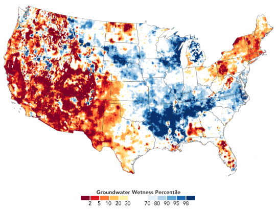
Drought Conditions Continue in Spring 2021 Almost half of the United States is currently experiencing some level of drought, and it is expected to worsen in upcoming months. Experts say the dry conditions could put a strain on water supplies and have important effects on the environment, such as increasing susceptibility to fire this summer. The top map above, built with data from the U.S. Drought Monitor, depicts areas of drought in the continental U.S. on March 23, 2021. It is based on measurements of climate, soil, and water conditions from more than 350 federal, state, and local observers around the country. NASA provides experimental measurements and models to this monitoring effort. The hardest hit areas are in Arizona, Utah, Nevada, Colorado, and New Mexico, where severe to exceptional drought developed in 2020 and persisted through winter. A weak summer monsoon season and ongoing La Niña conditions have stifled precipitation. La Niña is characterized by cooler than normal sea-surface temperatures in the central and eastern tropical Pacific Ocean. The associated weather patterns can push the jet stream north and cause it to curve, diverting storms and precipitation away from the region. The middle map below shows surface soil moisture as of March 29, 2021, as measured by the Gravity Recovery and Climate Experiment Follow-On (GRACE-FO) satellites. The colors depict the wetness percentile; that is, how the levels of soil moisture compare to long-term records for the month. Blue areas have more abundant water than usual, and orange and red areas have less. The darkest reds represent dry conditions that should occur only 2 percent of the time (about once every 50 years). In California, many of the state’s reservoirs are currently below historical averages due to an absence of strong winter storms and below-average snowpack in the Sierra Nevada. As of March 2, the state closed out its fifth consecutive month with below-average rain and snow. The current event fits the pattern of a long megadrought episode over the past two decades. A recent study showed 2000-2018 has been the driest period in the U.S. Southwest since the late 1500s. “The larger megadrought and this event are certainly not independent of one another,” said Andrew Badger, an author of the study and researcher at NASA’s Goddard Space Flight Center. “While the megadrought period is primarily focused on the southwest U.S., the current drought outlook also has a larger spatial extent as it extends farther east towards the Great Plains.” The lower map shows shallow groundwater storage as of March 29, 2021, as measured by the GRACE-FO satellites. The colors depict how the amount of groundwater compares to long-term records (1948-2010). Groundwater in aquifers is an important resource for crop irrigation and drinking water, and it also can sustain streams during dry periods. Groundwater takes months to rebound from drought, though, as it has to be slowly and steadily replenished by surface moisture that seeps down through soil and rock to the water table. The National Oceanic and Atmospheric Administration (NOAA) announced in its spring outlook that warmer-than-average temperatures this spring, below-average precipitation, and low soil moisture could lead drought conditions to expand in the Great Plains and southern Florida. Winter wheat crops already took a hit from a severe cold outbreak in February. “As with any extreme event, pinning down the root causes can be challenging. The important thing to remember is the underlying conditions of the megadrought that are present now were present for the 2012-2013 drought,” said Badger. “These conditions can prime the surface for drought events to become more extreme when the right atmospheric conditions arise.” NASA Earth Observatory images by Lauren Dauphin, using GRACE data from the National Drought Mitigation Center and data from the United States Drought Monitor at the University of Nebraska-Lincoln. Story by Kasha Patel.
4 notes
·
View notes
Text
Wildfires burn record 2 million acres in California; 14,000 firefighters pressed into service in San Francisco Bay area
Shaver Lake: Wildfires have burned a record 2 million acres in California this year, and the danger for more destruction is so high the US Forest Service announced Monday it was closing all eight national forests in the southern half of the state.
After a typically dry summer, California is parched heading into fall and what normally is the most dangerous time for wildfires. Two of the three largest fires in state history are burning in the San Francisco Bay Area. More than 14,000 firefighters are battling those fires and dozens of others more around California.
A three-day heat wave brought triple-digit temperatures to much of the state during Labor Day weekend. But right behind it was a weather system with dry winds that could fan fires. The state's largest utility, Pacific Gas & Electric, was preparing to cut power to 158,000 customers in 21 counties in the northern half of the state to reduce the possibility its lines and other equipment could spark new fires.
Randy Moore, regional forester for the Forest Service’s Pacific Southwest Region that covers California, announced the national forest closures and said the decision would be re-evaluated daily. Campgrounds at all national forests in the state also were closed.
“The wildfire situation throughout California is dangerous and must be taken seriously." Moore said. “Existing fires are displaying extreme fire behavior, new fire starts are likely, weather conditions are worsening, and we simply do not have enough resources to fully fight and contain every fire."
Lynne Tolmachoff, spokeswoman for the California Department of Forestry and Fire Protection, or Cal Fire, said it's “unnerving" to have reached a record for acreage burned when September and October usually are the worst for fires because vegetation has dried out and high winds are more common. The previous high was 1.96 million acres burned in 2018. Cal Fire began tracking the numbers in 1987.
While the two mammoth Bay Area fires were largely contained after burning for three weeks, firefighters struggled to corral several other major blazes ahead of the expected winds. Evacuation orders were expanded to more mountain communities Monday as the largest blaze, the Creek Fire, churned through the Sierra National Forest in Central California.
It was one of many recent major fires that has displayed terrifyingly swift movement. The fire moved 15 miles (24 kilometers) in a single day and burned 56 square miles (145.04 square kilometers).
Debra Rios wasn't home when the order came to evacuate her hometown of Auberry, just northeast of Fresno. Sheriff's deputies went to her ranch property to pick up her 92-year-old mother, Shirley MacLean. They reunited at an evacuation center.
“I hope like heck the fire doesn't reach my little ranch,” Rios said. “It’s not looking good right now. It’s an awfully big fire.”
Mountain roads saw a steady stream of cars and trucks leaving the community of about 2,300 on Monday afternoon.
Firefighters working in steep terrain saved the tiny town of Shaver Lake from flames that roared down hillsides toward a marina. About 30 houses were destroyed in the remote hamlet of Big Creek, resident Toby Wait said.
“About half the private homes in town burned down,” he said. “Words cannot even begin to describe the devastation of this community.”
A school, church, library, historic general store and a major hydroelectric plant were spared in the community of about 200 residents, Wait told the Fresno Bee.
Sheriff's deputies went door to door to make sure residents were complying with orders to leave. Officials hoped to keep the fire from pushing west toward Yosemite National Park.
The Creek Fire had charred more than 114 square miles (295 square kilometers) of timber after breaking out Friday. The nearly 1,000 firefighters on the scene had yet to get any containment. The cause had not been determined.
On Saturday, National Guard rescuers in two military helicopters airlifted 214 people to safety after flames trapped them in a wooded camping area near Mammoth Pool Reservoir. Two people were seriously injured and were among 12 hospitalised.
On Monday night, a military helicopter landed near Lake Edison to rescue people trapped by the Creek Fire, the Fresno Fire Department said on Twitter.
Chief Warrant Officer Joseph Rosamond, the pilot of a Chinook helicopter, said visibility was poor and winds increasingly strong during the three flights he made into the fire zone. His crew relied on night-vision goggles to search for a landing spot near a boat launch where flames came within 50 feet (15.24 meters) of the aircraft.
The injured, along with women and children, took priority on the first airlift, which filled both helicopters to capacity, he said.
“We started getting information about how many people were out there, how many people to expect, and that number kept growing. So we knew that it was a dire situation,” Rosamond said.
Rosamond called the conditions “extreme” and said it was one of the most difficult flying missions in his 25 years as a military pilot.
Record-breaking temperatures were driving the highest power use of the year, and transmission losses because of wildfires have cut into supplies. Throughout the holiday weekend, the California Independent System Operator that manages the state’s power grid warned of outages if residents didn’t reduce their electricity usage. But none had occurred by late Monday afternoon.
Pacific Gas & Electric warned it might cut power starting late Monday because of the increased fire danger. Some of the state’s largest and deadliest fires in recent years have been sparked by downed power lines and other utility equipment.
PG&E received criticism for its handling of planned outages last year. The utility said it has learned from past problems, “and this year will be making events smaller in size, shorter in length and smarter for customers.”
In Southern California, crews scrambled to douse several fires that roared to life in searing temperatures, including one that closed mountain roads in Angeles National Forest and forced the evacuation of the historic Mount Wilson Observatory.
Cal Fire said a blaze in San Bernardino County called the El Dorado Fire started Saturday morning and was caused by a smoke-generating pyrotechnic device used by a couple to reveal their baby's gender. In eastern San Diego County, a fire destroyed at least 10 structures after burning 16 square miles (41.44 square kilometers) and prompting evacuations near the remote community of Alpine in the Cleveland National Forest.
California has seen 900 wildfires since 15 August, many of them started by an intense series of thousands of lightning strikes in mid-August. There have been eight fire deaths and more than 3,300 structures destroyed.
via Blogger https://ift.tt/2GvAwcH
0 notes
Text
Headlines
Trump declares national emergency to get $8 billion for wall
(AP) Defiant in the face of a stinging budget defeat, President Donald Trump declared a national emergency Friday to get more federal dollars for his long-promised wall at the U.S.-Mexico border, relying on a broad interpretation of his powers that was certain to trigger stiff legal challenges.
Snow storm brings whiteout conditions to California’s Sierra
(AP) Skiers eager to hit the slopes had to sit out a Presidents’ Day holiday weekend as heavy snow and rain fell for a fourth straight day Friday in California’s mountains, where the snow was so deep in some areas plows couldn’t go out and cities were running out of places to pile it.
Amazon dumps NYC headquarters and its promised 25,000 jobs
(AP) Amazon abruptly dropped plans Thursday for a big new headquarters in New York that would have brought 25,000 jobs to the city, reversing course after politicians and activists objected to the nearly $3 billion in incentives promised to what is already one of the world’s richest, most powerful companies.
Mexican President Announces Bailout for Cash-Strapped Pemex
(AP) Mexican President Andres Manuel Lopez Obrador announced a $3.9 billion bailout for the country’s cash-strapped, state-owned oil company Friday and promised it an additional $1.6 billion in revenue, making it a rescue package of up to $5.5 billion.
Mexican President Visits ‘El Chapo’s’ Home Turf Seeking Reconciliation
(Reuters) Mexican President Andres Manuel Lopez Obrador visited the birthplace of the country’s most infamous drug trafficker, Joaquin “El Chapo” Guzman, on Friday, calling for peace and reconciliation days after a U.S. jury convicted the kingpin.
Venezuela Opposition’s U.S. Envoy Has No ‘Crystal Ball’ on Maduro Exit
(Reuters) The Venezuelan opposition’s envoy to the United States said on Friday there was no telling how long it would take to oust President Nicolas Maduro but that efforts to end his rule were “irreversible,” despite the failure so far to convince the military to abandon him.
Venezuela Opposition Slams Raid of NGO That Supports Humanitarian Aid
(Reuters) Venezuela’s opposition-run congress accused the police on Friday of illegally raiding the headquarters of a non-governmental organization that supports their plan to bring humanitarian aid into the country and confiscating medicine and baby milk.
Spain Launches New Push to Exhume Dictator Franco’s Remains
(AP) Spanish authorities are giving Gen. Francisco Franco’s descendants a 15-day deadline to find a new burial place for the former dictator before his remains are exhumed from a lavish mausoleum.
World Jewish Congress Concerned About Neo-Nazism in Europe
(AP) The World Jewish Congress is voicing concern about the rise of far-right activities across Europe attempting to promote anti-Semitism, hatred, xenophobia, and Nazi glorification among young people.
U.S. Adviser Bolton Promises India Support After Kashmir Attack
(Reuters) U.S. National Security Adviser John Bolton spoke to his Indian counterpart promising support to bring those responsible for a deadly car bombing in disputed Kashmir to justice, the Indian Foreign Ministry said on Saturday.
Iran Threatens Retaliation Over Car Bombing That Killed 27
(AP) The head of Iran’s powerful Revolutionary Guard threatened to retaliate against neighboring Saudi Arabia and United Arab Emirates over a suicide car bombing this week that killed 27 members of the elite organization.
Lebanon’s Cabinet Wins Vote of Confidence in Parliament
(AP) Lebanon’s parliament gave the new government of Prime Minister Saad Hariri a vote of confidence after days of heated debates and harsh verbal exchanges.
SDF Take Control of Last IS Enclave in East Syria--Observatory
(Reuters) The Syrian Observatory for Human Rights said U.S.-backed fighters seized the last Islamic State enclave in eastern Syria on Saturday after the jihadists who were still there surrendered.
Seven Militants Killed, 15 Troops Killed or Wounded in North Sinai: Egyptian Military
(Reuters) Seven militants were killed and 15 Egyptian military personnel were killed or wounded in a clash in North Sinai on Saturday, the Egyptian military said.
Zimbabwean Rescuers Pull Out Eight Trapped Miners Alive
(Reuters) Zimbabwean rescuers pulled out eight illegal gold miners alive on Saturday out of about 70 people who were earlier this week trapped in flooded shafts, an accident that the government has declared a disaster, officials and witnesses said.
66 killed in Nigerian state before presidential election
(AP) Authorities in Nigeria’s Kaduna state are reporting at least 66 deaths in a wave of violence just before the country’s presidential election.
0 notes
Text
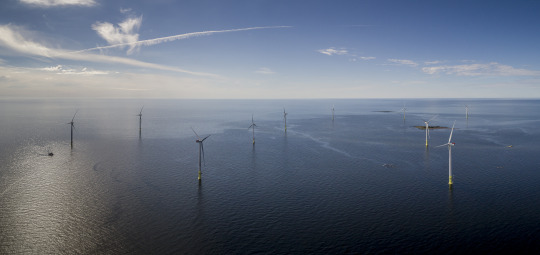
Can Offshore Wind Turbines Succeed in the Great Lakes?
Ice jams and bird and bat deaths will determine the answer
Aside from a small pilot program along the coast of Finland, offshore wind turbines have not been placed in waters that freeze during winter. Moving ice can act like a battering ram, pushed by storms and unpredictable currents, knocking into masts that hold up spinning blades. A major test could be coming soon in Lake Erie near Cleveland. If the six turbines in the Icebreaker Windpower project are built, they could usher in a new era of offshore power in freshwater lakes, rather than salty coastal seas, which has never been done.
The Ohio Power Siting Board has given preliminary approval to Icebreaker, to be built by the nonprofit Lake Erie Energy Development Corp. (LEEDCo). And the Ohio Environmental Protection Agency has ruled the installation complies with federal standards relating to water pollution. Final approval could come this fall, and the turbines could be operating within three years—if objections from concerned groups are satisfied.
Icebreaker would be the second offshore wind farm in the U.S. The Block Island Wind Farm—13 miles off the Rhode Island coast—began generating electricity in December 2016. The $126-million project in Lake Erie would eventually be owned by Fred. Olsen Renewables in Norway, which has 23 operational and planned wind farms (onshore and offshore) in four European countries. The Lake Erie turbines would produce about 21.7 megawatts of electricity, enough for about 7,500 homes. The 200-foot blades would rise 479 feet at their highest point from the water’s surface.
Enthusiasts say Great Lakes wind energy has some advantages over Atlantic coast locations: shallower floor depth, smaller waves, no hurricanes, electrical grids close to shore, fewer effects on commercial fishing and competitive wind speed. If Icebreaker succeeds, they think hundreds of Lake Erie turbines could follow.
The key to success will be how well Icebreaker deals with what Ohioans call the “ice shove.” Winter winds and water currents push thick ice sheets around, at times piling them 30 to 50 feet high close to shore. The sheets are known for wreaking havoc on waterfront infrastructure. Can the wind turbines survive?
Tahkoluoto offshore wind farm in Finland
SLOW START
The Icebreaker project had been held up for several years because of concerns the turning blades would kill too many birds. The plan was tentatively approved in July after Ohio regulators finally determined there would be “minimum environmental impact” to wildlife. They did add more than 30 environmental caveats (pdf) Icebreaker will need to address, most of them related to bird safety.
The persistent issue has been whether the turbines would adversely affect migratory birds on the eastern edge of the Mississippi Flyway. As part of the approval agreement, LEEDCo must develop and install sophisticated radar-monitoring equipment in the lake before construction begins to determine how the wind turbines might affect birds and bats. The company has already done migratory bird studies and found the impact would be minimal. A U.S. Geological Survey ornithologist found an estimated 21 to 42 birds and 21 to 83 bats would be killed by all the turbines annually. The U.S. Fish and Wildlife Service wrote in March that Icebreaker “has limited direct risk to migrating birds and bats.”
Environmental organizations have been split on this issue. The Sierra Club, The Nature Conservancy, Ohio Environmental Council and Environmental Defense Fund back Lake Erie offshore wind as a better alternative for wildlife than the more than 20 coal- and natural gas–fired power plants operating in Ohio. The American Bird Conservancy and Ohio-based Black Swamp Bird Observatory, however, have opposed the plan because they contend (pdf) the wind farm would result in much higher aviary and bat deaths.
The National Audubon Society supported the addition of migratory bird monitoring to “set the standard for wind energy development, if any, in the entire Great Lakes.” One species that needs to be monitored and protected, according to Audubon, is the red-breasted merganser, a diving duck that can be found on Lake Erie in the late fall.
THE ICE TEST
Whether the tall turbine masts can survive ice sheets comes down to two primary innovations: Lake Erie is the shallowest of the Great Lakes, and averages about 78 percent ice coverage each winter, the highest of the five lakes. The ice challenge will differ from that faced in the Baltic Sea, however. Frozen saltwater tends to hang more below the waterline than does frozen freshwater, which floats on top. Icebreaker will install an inverted cone on the towers at the water level. The idea is that by tapering from a wide flare higher up on the mast down to a narrow base at the waterline, the cone can deflect ice flowing toward the masts, pushing it down and away. Engineers at Finland’s Tahkoluoto pilot installation installed similar cones for their surface ice. Engineers were watching last winter to see how the masts would do, but the weather was mild and there was little ice shove.
The second innovation that will be tried on Icebreaker involves how the masts will be attached to the lake floor. The “mono bucket,” a suction cup–style, circular steel bucket, 56 feet in diameter, will form the foundation. Dropped face down to the bottom from a barge, air and water will then be pumped out of the hollow inside, causing the cup to get pulled solidly into the lake bed a few meters deep. The natural pressure then holds it in place. The process takes a few days instead of the few months needed to install a conventional offshore turbine foundation. This approach has been used a half dozen times in deeper European coastal waters but experts think Lake Erie’s shallowness (60 feet at the turbine site) and lesser wave action is an even better fit, because stress on the foundation will be less. The unanswered question is whether the mono buckets will hold up as the anchor for a mast that might get rocked by ice for about four months each year.
If the bucket handles Lake Erie, it could be sought for wind farms proposed along the U.S. east coast. Willett Kempton, a professor in the University of Delaware’s School of Marine Science and Policy, says that is because the depth of the Atlantic Ocean’s continental shelf there is generally between the depths of Lake Erie and the North Sea.
PRICE WILL PREVAIL
Building wind farms offshore is still more expensive than erecting them on land, and the price of electricity produced offshore has been higher because of that. Block Island has been selling electricity to the mainland grid for 24.4 cents per kilowatt-hour (kWh), which is high in general—but a future Maryland project is guaranteeing 13.2 cents. Some European companies sell wind power from the North Sea below 10 cents. The average electricity price in the U.S. is about 13 cents per kWh, but the cost varies quite a bit from state to state. LEEDCo says its price will be “well below” that of Block Island’s, but adds it cannot be more specific at this time.
Whether Icebreaker could succeed economically may be more of a regional matter. The Midwest has ample natural gas resources and coal-fired power plants, and onshore wind turbines are moving in from the west. Those factors make the price of electricity in the Midwest generally cheaper than it is in the Northeast. Turbines in the Great Lakes region also may struggle to compete. “I don’t see much future movement in offshore wind after this Lake Erie project,” says Charles Standridge, professor of engineering at Grand Valley State University in Michigan, who has studied offshore wind viability in Lake Michigan. Open space for land turbines, battery storage improvements and increased solar power make Midwest energy production very competitive right now, Standridge says. Unless Great Lakes offshore wind producers can drop the costs “rapidly,” he says, “it is likely going to be pushed aside for a while.”
Still, the Icebreaker organizers are anxious to see how things play out. “We really believe that this little project will open some eyes about what is possible” in freshwater lakes, says David Karpinski, vice president of operations. “Costs will come down…and Cleveland businesses will see the value in this as a game changer in the local economy. People everywhere want cleaner and more reliable and cheaper energy, and this project will show the value of doing that in the Great Lakes.”
(source: Scientific American)
0 notes
Link
Excerpt:
When searing black lava from fissure 8 slid into the Pacific Ocean at Kapoho Bay on June 3, it had been five weeks since the collapse of the Pu‘u ‘Ō‘ō crater, along the eastern rift zone of the Kīlauea volcano on Hawaii's Big Island. Toxic, acid-laden steam billowed high above boiling waves. Within 36 hours, the bay became paved over by lava, creating a new coastline almost a mile out and destroying shallow-water coral reefs and tidepools.
“It’s been an absolute loss,” said marine biologist Misaki Takabayashi of the University of Hawaii at Hilo. The area was popular with snorkelers for its easy access and intense beauty. Takabayashi described the view as floating above a colorful coral reef set against stark black basalt. “When people would go, they were in awe,” she told me.
The name Kapoho derives from the Hawaiian word poho, meaning a depression or hollow. Those dips in the seafloor created the Wai‘ōpae Tidepools, part of which were protected by the state as a Marine Life Conservation District. Takabayashi’s team had been studying those for 12 years. They are now gone as well.
Pu‘u ‘Ō‘ō, 2,300 feet up on Kīlauea, has been erupting continuously since 1983, delighting tourists and repeatedly inundating landscapes and communities downstream with destructive lava flows. The current event has been associated with some 12,000 earthquakes, the largest a 6.9-magnitude shaker on May 4. More than 20 separate fissures in the earth have opened.
Kīlauea is the prime attraction of Hawaii Volcanoes National Park, a UNESCO World Heritage Site that saw over 2 million visitors last year. Now, most of the park is closed indefinitely.
Park roads are cracked and covered with ash from eruptions that have shot up 10,000-foot-high plumes. The Hawaii Volcano Observatory, Jaggar Museum, and emergency operations center have all experienced considerable earthquake damage. The entire park is without running water.

A MASSIVE LAZE (LAVA HAZE) PLUME RISES FROM KAPOHO BAY ON THE MORNING OF JUNE 6. | PHOTO COURTESY OF THE U.S. GEOLOGICAL SURVEY
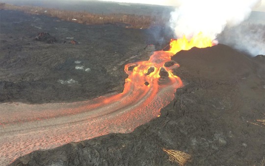
LAVA FOUNTAINS ERUPT FROM FISSURE 8, SENDING A RIVER OF MOLTEN ROCK SEVEN MILES DOWN TO THE OCEAN. | PHOTO COURTESY OF THE U.S. GEOLOGICAL SURVEY

LAZE PLUMES RISE FROM THE LAVA DELTA THAT HAS FORMED OVER KAPOHO BAY. | PHOTO COURTESY OF THE U.S. GEOLOGICAL SURVEY
0 notes
Photo

From NASA Earth Observatory Image of the Day; April 4, 2018:
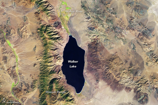
Disappearing Walker Lake
Since 1960, the Aral Sea in Kazakhstan has lost 90 percent of its volume. Iran’s Lake Urmia has declined even more quickly, shrinking by that amount since 2000. In the United States, the story of Walker Lake in Nevada is similar, though the rate of decline has been slower.
Walker Lake lost 90 percent of its volume beginning roughly a century ago, around the time farmers and cattlemen established communities in Walker Basin. The lake, about 120 kilometers (75 miles) southeast of Reno, is fed from the north by the Walker River and has no natural outlet. Its water comes mostly from spring snowmelt running down from the Sierra Nevada, but much of that water is diverted before it reaches the lake; it is used to irrigate alfalfa fields and pasture grass in the Antelope, Bridgeport, Smith, and Mason valleys.
As the inflow of fresh water has declined, the concentration of dissolved solids (mainly salt) in the lake has increased—from 3 grams per liter in the 1880s to 17 grams per liter now, making the lake about half as salty as seawater. As has been the case with other shrinking salt lakes, a sharp increase in salinity had a major effect on fish and other wildlife. Of the 17 fish species that historically lived in Walker Lake, only 3 were still present in 1979. The Lahontan cutthroat trout is listed as a threatened species and only survives in the lake because of stocking.
Over several decades, Landsat satellites have observed the water level change at Walker Lake. This pair of false-color Landsat images shows it on October 22, 1988, (top) and October 22, 2017 (bottom). The lake sits in a valley between the Wassuk Range to the west and the Gillis Range to the east. Cottonwood, willow, Russian olive, tamarisk, and grasses grow along the banks of the Walker River. Pinyon-juniper forests grow on the eastern slopes of the Wassuk Range.
In a study published in Nature Geoscience, a team of scientists led by Wayne Wurtsbaugh of Utah State University discussed how water managers might respond to save Walker Lake and other declining salt lakes. They calculated that increasing the inflow of fresh water to Walker Lake by 24 percent would increase salinity levels enough to preserve lake ecosystems and wildlife. Doing the same for Lake Urmia would require an 83 percent increase. In the case of the Aral Sea, water managers proposed saving a small section of the lake—about 5 percent of its former size—to maintain fish populations even as the rest of the basin dries out.
“There is a tendency to invoke ‘climate change’ as the culprit for the decline of saline lakes without fully understanding all of the hydrological balances,” the scientists said. “Climate change—with warmer temperatures, increased evaporation, and altered precipitation—does indeed represent a pervasive long-term problem for saline lakes sustainability, [but] water development (agriculture, mining, and cities) in arid basins generally represents a larger and more immediate challenge.”
References
High Country News (2011, August 10) Re-watering Nevada’s dying Walker Lake. Accessed March 28, 2018.
U.S. Geological Survey Hydrology of the Walker River Basin. Accessed March 28, 2018.
Wurtsbaugh, W.A. et al, (2017) Decline of the world's saline lakes. Nature Geoscience, 10, 816-817.
Walker Basin Conservancy History of Walker Lake. Accessed March 28, 2018.
NASA Earth Observatory images by Joshua Stevens, using Landsat data from the U.S. Geological Survey. Story by Adam Voiland. Instrument(s): Landsat 5 - TM; Landsat 8 - OLI
#earth observatory#long post#climate change#land use#water usage#shrinking lake#Walker Lake#Nevada#landsat 5#landsat 8
0 notes
Last Seen Blogs

luffylovie
♡ luffylovie ♡

ginnyweatherby
Queen of Doofenthirst

imnobodyuknow
ImNobodyUKnow

hes-a-bit-of-a-prat
free palestine

anti0800
✦⁎°.✧°₊•ᡕᠵ᠊ᡃ່࡚ࠢ࠘⸝ ່ࠡࠣ᠊߯