#gryphonfolk homeland
Photo
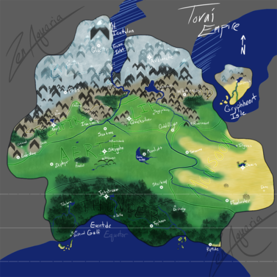
Something I’d been working on, on and off, for the past week-ish, as part of my project of making one of my species into a D&D supplement.
I’m not really a cartographer sort, but the Toraion (my gryphonfolk) homeland has needed a new map for ages. The old one was long outdated. xD
This might be a final, might just be a draft. Dunno yet! But it is approximately how their native lands are laid out and where their cities are located. There are smaller towns, but they are not featured only because I ran out of names for settlements for now. The surrounding lands are not concrete; the world around the Torai Empire hasn’t been officially mapped yet due to life obligations on the part of the Storymaster (my Taller Half). x3
So there’s the Holds themselves, their capitals, major cities, and minor cities. Gryphheart Isle is Lifeblood territory, and those little southern archipelagos are Thunder territory. Yeah I forgot a map key. Shush. lol Some of the Hold borders follow the rivers and might be hard to see, I realize.
Holds - Capitals - Major Cities - Minor Cities
Aerie - Skygate - Sunhome, Moonloft, Zephyr, Starkeep - Riversbank, Pinefall, Hillroost
Blizzard - Avalanche - Frost, Glacier - Rime, Fjord, Hailstone, Crevasse
Lifeblood - Quicksilver - Whitecross, Goldflight - Lakesmoth, Sageplains, Rivermount, Loneperch
Monsoon - Oasis - Savanna, Floodwater - Tallgrass, Dune
Steelfire - Anvil - Lodestone, Ironspark - Orewood, Geode, Coldforge
Thunder - Jetstream - Typhoon, Riptide - Tidebore, Delta, Duskedge, Port Driftwood
#map#fantasy map#D&D homebrew#dungeons and dragons#toraion#torai empire#gryphonfolk homeland#worldbuilding#art#not pony
18 notes
·
View notes
Last Seen Blogs

quoctrieumkt
Quốc Triệu MKT

calmwithkari
Calm with Kari

mommy-samantha222
Mommy_samantha

luludohs
lulu
mommy-samantha222
Mommy_samantha