#it was colonizers calling them lakes. do you think those guys knew fuck shit about anything.
Text
NOAA finally has a predictive map to show how water levels in Michigan/the great lakes region could adjust with climate change. (Having a hell of a time finding the link to the actual tool, but i think its this one.) I'm really interested in this bc for YEARS everyone has said "coastal regions will be the most affected" but also that "the great lakes will be relatively protected" in the same breath. Really, the only prediction I've seen is that we will get hella climate refugees from the drought-ridden areas. In fact, some people I've spoken with have had an outright blase attitude about how climate change is going to hit Michigan.
I've been trying to find info about the coastlines and weather changing for four YEARS and haven't been able to find anything other than "no one knows, but NOAA is watching it." NOAA has a fuckton of really interesting sea vessels and research initiatives around here btw! I follow their aurora forecast religiously, they have all kinds of ROVs that explore the formations and sinkholes ans shipwrecks at the bottoms of the lakes, and now this, which I've obviously been waiting for someone to address.
If you live in the coastal region of Michigan you can SEE it happening in real time. Cliffs eroding, homes spilling into the sea, the shoreline and water levels changing dramatically between seasons. When I was a kid, there were yards and yards worth of beach and dunes to walk across to get to the water. Like easily half a block or more. When I came back in 2020, there was about 6 feet of beach. In just 4 years, the water levels have gone back and forth so much that it goes from being like this- so flooded there's no more beach- to Hamlin Lake this spring, following the extreme lack of snowfall:
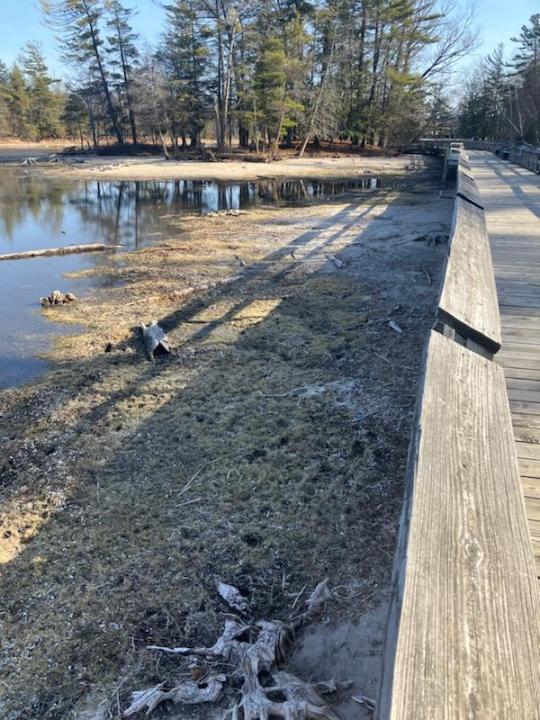
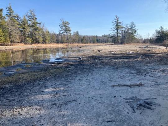
My parents took these a few weeks ago. This is a lake, not a river or a creek. This is typically a BEACH. There is a dam on the far side of this lake. There are boardwalks to walk across the water and places where usually, you'd be able to kayak or canoe under the bridge. This campground is one of the most sought after, highest rated campgrounds in the entire United States. You have to reserve on New Years the minute they open registration to get a site.
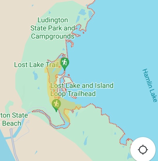
Tbf Hamlin Lake is enormous, but the part that's dry.... is also not small, and its THE spot, right at the campsite. I highlighted it here.
Seeing it this dry is at least as shocking as going to lake michigan and seeing the water level randomly get so high you can't even put a towel down. It's at least as shocking as how unbelievably violent the wind and weather has gotten, how common gale force winds strong enough to shake houses and tear off siding are, the way they cannot reliably predict even normal weather on the coast anymore. The way the popup storms loom, undetected on the radar. It's at least as shocking as watching the dunes get smaller and smaller and cleave apart the more erosion they undergo, the more people that walk on them, watching the dunegrass and the scraggly beach trees straining at the roots to hold the earth together. It's at least as shocking as every time I've seen they clear cut a new swath of national forest for cabin rentals. We can't keep doing this. We can't keep doing this we can't keep doing this.
Anyway, this is just your friendly reminder that the Great Lakes ARE, in fact, part of America's coastal region. they are inland, freshwater seas rather than "lakes" as the names imply, and they, too, cannot remain unchanged by global warming.
Remember this when you think about the six YEARS it took for Flint to get clean water.
Just some food for thought.
#me#home#climate change#us politics#it was colonizers calling them lakes. do you think those guys knew fuck shit about anything.#the french ones no less.#pere marquette had his filthy little hands all OVER this region#michigan
2 notes
·
View notes
Last Seen Blogs

orangefreckles
Well Well Well

is-the-skeleon-kissable
Is the skeleton kissable?

ciameth
CIAMETH

miniatureconnoisseurstrawberry
Sin título

ransolmcasterfo
ransolmcasterfo > porternash