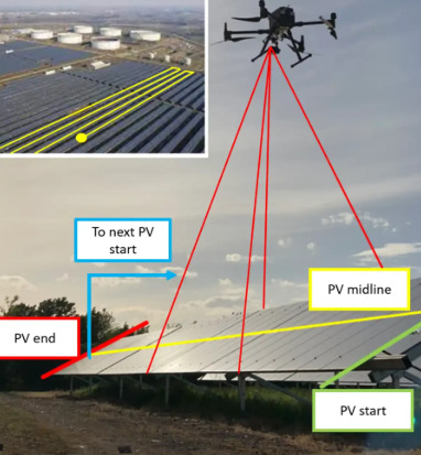
#mapping drone
Explore tagged Tumblr posts
Visit Tumblr Blog
Explore Tumblr blogs with no restrictions, modern design and the best experience.
Last Seen Tumblr Blogs


Fun Fact
In 2020, Tumblr had 29.4 million users in the US.
Text
Drone Mapping: Revolutionizing Aerial Surveying
Introduction
Drone mapping is an advanced technology that utilizes UAVs (unmanned aerial vehicles) to capture high-resolution aerial imagery and generate accurate, georeferenced maps. This innovation is transforming industries such as agriculture, construction, urban planning, and environmental monitoring by providing cost-effective and efficient mapping solutions.
How Drone Mapping Works
Drones equipped with high-resolution cameras and GPS sensors fly over designated areas, capturing overlapping images. These images are processed using photogrammetry software to create detailed 2D orthomosaic maps or 3D models. The final output provides accurate spatial data, enabling professionals to analyze terrain, infrastructure, and environmental changes.
Key Benefits
High Precision & Accuracy – Advanced GPS and imaging technologies ensure detailed, distortion-free maps.
Time & Cost Efficiency – Reduces the need for manual surveys, saving time and resources.
Enhanced Safety – Eliminates the risks associated with traditional land surveying in hazardous environments.
Real-Time Data Collection – Provides up-to-date information for better decision-making.
Versatile Applications – Supports industries such as construction, agriculture, and disaster management.
Applications of Drone Mapping
Agriculture: Monitors crop health, irrigation needs, and soil conditions for precision farming.
Construction & Infrastructure: Tracks project progress, assists in site planning, and ensures structural integrity.
Urban Planning & Land Development: Aids in zoning, smart city development, and transportation planning.
Disaster Management & Emergency Response: Provides critical mapping for search and rescue, damage assessment, and recovery planning.
Environmental Monitoring: Helps track deforestation, coastal erosion, and wildlife habitats.
Challenges & Considerations
Despite its advantages, drone mapping faces challenges such as regulatory restrictions, weather dependency, and the need for skilled operators. However, advancements in AI, automation, and data processing are helping mitigate these obstacles, making drone mapping more accessible and efficient.
Conclusion
Drone mapping is revolutionizing industries by providing fast, accurate, and cost-effective mapping solutions. As technology continues to evolve, the potential for drone mapping will expand, improving efficiency, safety, and decision-making across various sectors. With ongoing innovations, drones will remain a crucial tool for modern aerial surveying and geospatial analysis.
0 notes
Text

Ways To Improve Accuracy Of Drone Mapping Programs In Challenging Environments
Drone mapping is seriously cool, but things get tricky when flying in challenging environments like dense forests, mountainous terrains, or areas with sketchy weather. If you’ve ever tried to capture high-precision maps and felt like your drone was fighting against nature, don't worry—you’re not alone! In this blog-style breakdown, we will cover some of the best ways to improve drone mapping accuracy, especially in tough situations.
1. Use Ground Control Points (GCPs) Like A Pro
If you want next-level accuracy, Ground Control Points (GCPs) are your best friends. These are marked spots on the ground with known coordinates, which you can later use to align your map data. Without GCPs, your drone might think it's doing a great job, but your map could be slightly off. In challenging environments, this slight miscalculation can become a big deal. So, invest some time in setting up GCPs around your area before starting the flight. It’s a small effort that pays off big when you’re trying to get precise results.
2. Pick The Right Sensors
Not all drone cameras are built the same. In tough environments, traditional RGB cameras can struggle to capture every detail. This is where specialized sensors come into play. LiDAR (Light Detection and Ranging) is a solid choice for dense forests or areas with lots of obstacles. It sends out pulses of light and measures how long they take to return. This helps the drone “see” through obstacles and create accurate 3D maps. Multispectral cameras are another good option, especially in agricultural or forestry settings. These cameras pick up information that human eyes can’t, giving you more detailed data to work with.
3. Fly At The Right Altitude And Speed
Flying too high or too fast can throw off your map accuracy, especially in tough environments. The rule of thumb is simple: the lower and slower, the better. When you’re flying lower, the drone’s camera can pick up more details, and flying slower allows it to capture more precise data points. In environments where obstacles like trees or cliffs can interfere with data collection, this approach becomes even more critical.
4. Pre-Plan Your Flight Paths
Before launching your drone, make sure you’ve pre-planned your flight path. Use software that allows you to set waypoints and control your drone's flight with pinpoint precision. In challenging environments, this planning helps avoid obstacles, ensuring your drone stays on course and covers the entire area. Plus, you’ll avoid any last-minute panic when your drone suddenly approaches a giant tree!
5. Improve Your Post-Processing Game
Once your drone lands, the mission isn’t over yet. The magic happens in post-processing! The software you use to stitch the images and generate the map is just as important as the flight itself. Make sure you're using software with advanced algorithms that can correct for any distortions caused by rough terrains. Also, try to use tools that support georeferencing so that you can align your map to real-world coordinates more accurately. This will dramatically improve the quality of your final map.
Why The AUTEL ALPHA Is The Ultimate Drone For Challenging Mapping Jobs!
Now, let us save you some trouble searching for the best drone to handle all mapping needs. Meet the AUTEL ALPHA from MAVDRONES—your new mapping sidekick! This beast of a drone is specifically designed to tackle tough environments with ease. Equipped with a high-quality LiDAR sensor and a multispectral camera, it doesn’t just capture stunning visuals; it goes deep to deliver the kind of data you need for accurate mapping. It also features advanced waypoint planning and obstacle avoidance, making it ideal for flying in tricky environments like dense forests or rugged terrains.
Plus, with its long flight time and ability to maintain stability even in windy conditions, you won’t have to worry about your drone cutting the mission short. If you’re serious about drone mapping and want to level up your game in challenging environments, the AUTEL ALPHA is where it’s at. It’s like having a mapping expert in the sky! So there you have it! From using GCPs to flying smart, these tips will help you get the most accurate drone maps, no matter the environment. Trust the AUTEL ALPHA to make your mapping missions smooth and successful.
0 notes
Text
Invest in Smarter Construction with Drone Technology

The construction industry has long struggled with issues like project delays, budget overruns, and safety risks. These challenges can be mitigated significantly with the use of drones, which provide high-quality data and enhanced oversight in ways that traditional methods cannot match. Here are some key reasons why drones are gaining traction in construction:
Accurate Data Collection: Drones equipped with high-resolution cameras and advanced sensors can capture detailed aerial images and generate 2D maps and 3D models of construction sites. This allows for precise planning and monitoring of progress, reducing the likelihood of costly mistakes.
Improved Safety: Construction sites can be dangerous, especially when working at heights or in hazardous areas. Drones allow project managers to monitor these areas without exposing workers to risk, making safety inspections quicker and safer.
Cost and Time Savings: Drones can significantly reduce the amount of time spent on site inspections, surveys, and monitoring. Tasks that traditionally take days or weeks can now be completed in a matter of hours. Moreover, the data collected helps minimize rework and optimize resource allocation, cutting down costs.
Enhanced Communication and Collaboration: High-definition images and real-time video feeds from drones make it easier for all stakeholders — engineers, contractors, and clients — to stay informed about project progress. This improved communication leads to better collaboration and quicker decision-making.
Key Applications of Drones in Construction
While the general advantages of drones are evident, their real impact lies in specific applications tailored to the needs of the construction industry. Below are some of the primary ways drones are being used to transform construction projects:
1. Land Surveying and Mapping
One of the most time-consuming aspects of pre-construction is land surveying. Drones simplify this process by quickly capturing aerial data over vast areas. Using photogrammetry, drones can create precise 2D and 3D maps of the terrain. These maps help construction teams understand the topography, identify potential obstacles, and plan the project more effectively. Compared to traditional ground-based methods, drones deliver faster results with higher accuracy.
2. Site Monitoring and Progress Tracking
Drones can perform regular site flyovers, capturing updated aerial images and video footage. This data provides project managers with a clear view of the entire construction site, allowing them to track progress in real-time. By comparing current drone-captured data with initial project plans, managers can quickly identify discrepancies and address potential issues before they escalate. This real-time monitoring can also help track material usage and prevent theft or misuse.
3. Inspections and Safety Audits
Safety is a major concern on construction sites, especially in large-scale projects with complex structures like skyscrapers, bridges, or tunnels. Drones equipped with thermal cameras and other specialized sensors can conduct safety audits by inspecting hard-to-reach areas such as high beams, rooftops, and confined spaces. These inspections can be done more efficiently and safely than traditional methods, allowing for early detection of structural issues or safety hazards.
4. Volumetric Measurements
Calculating stockpile volumes and earthworks has traditionally been an expensive and labor-intensive process. Drones streamline this process by capturing aerial images that are converted into volumetric data using specialized software. This is particularly useful in tracking materials like gravel, sand, or soil, ensuring that supply levels are accurately measured and costs are controlled.
5. Marketing and Client Engagement
Drone footage is not just for internal use; it can also be a powerful marketing tool. High-quality aerial videos of construction progress are impressive visual aids that can be shared with clients, stakeholders, and potential investors. These visuals provide a compelling way to showcase the capabilities of a construction firm and can be instrumental in winning new business.
The Financial and Competitive Advantage
Investing in drone technology for construction offers both short-term and long-term financial benefits. In the short term, the reduced labor costs and faster project timelines result in immediate savings. In the long term, drones improve the overall efficiency and accuracy of construction projects, leading to fewer delays and reduced rework, which translates to better profit margins.
Additionally, companies that integrate drone technology into their workflows gain a competitive edge in an industry that is increasingly prioritizing innovation. Being able to deliver projects on time, within budget, and with enhanced safety measures is a key differentiator in today’s construction landscape.
Conclusion
Drone technology is no longer a futuristic concept in construction — it’s here, and it’s transforming the way the industry operates. From improving safety and efficiency to providing precise data for better decision-making, drones are the smart investment that can drive your construction business forward. By adopting drone technology, construction firms can stay ahead of the curve, reduce costs, and complete projects more efficiently and safely than ever before.
#2D Drone mapping#2D Drone#Drone Mapping#Mapping Drone#Drone Mapping Software#Drone Innovation#Drone In Construction
1 note
·
View note
Text
#railroad track maintenance tools#Rail Thermometer#Rail Track Gauges#Mapping Drone#Brunton Compasses#Echosounder#CORS
0 notes
Text
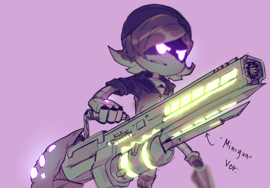
Have you seen the Murder Drones Episode 8 teaser???
I saw that part with Uzi and her gun
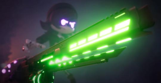
And I thought that it was a minigun version of it that her tail was helping her support it or something. I honestly thought it was like-
#Murder drones#uzi doorman#Uzi#In my defense I just woke up when I watched the teaser#Guns are hard and I didn't want to spend too much time on this#gradient maps are so much fun#doodles#So happy for the new episode yet so sad that there will be no second season
1K notes
·
View notes
Text

Gold, Incense and Myrrh
#so a friend introduced me to the We three kings warriorcats MAP and WHOOPS somehow this happened??#yeah; dunno either#murder drones#md#serial designation n#serial designation v#serial designation j#sd n#sd v#sd j#md n#md v#md j#fanart#EDIT whoops i mixed something. now u guys can reblog
86 notes
·
View notes
Text
hey chat does anyone know any murder drones maps that may be open atm
I’ve been thinking about applying for some
#If you have your own you’re hosting feel free to advertise#We need more map calls in the Md community#k’s rants#murder drones#Also for the record I mean like animation maps💀#If anyone..got confused
31 notes
·
View notes
Text
Hate having weird irrational fears because things in videogames like diving in crystal clear water will scare the shit out of the thalassophobe in me, or this big fucking boat will set off my megalophobia.

#Don't get me started on whenever I had to dive in Fallout 4#That shit was a fucking *nightmare* for me#whenever I'm flying around this map I always jumpscare myself when I turn my camera to see Nyunkrepf's Hope just sitting there#Does it do anything? Nope! Nothing but make me incredibly unsettled at least.#well that and emit a low droning sound...#Z speaks
14 notes
·
View notes
Text

The map shows the geography of explosions and fires in Russian oil refineries and oil depots. The Russians try very hard to hide the extent of the losses suffered. Source: Киев за три дня
12 notes
·
View notes
Text
Wait!
#murder drones#md cyn#fanart#maps#murder drones cyn#worker drone#murder drones animatic#animation meme#meme
15 notes
·
View notes
Text
man if i had an actual plot structure to use as scaffolding (because i can’t really do slice of life or things like it) i could write so many N and Uzi words that are just the actual practicalities and obstacles (varying in size and some seen, some unforeseen) of an interspecies relationship
#banana.txt#murder drones#esp for the no solver stuff i tend to work with on my way early pilot era fics#like the diet is an obvious one but there’s also other physical needs. behavior. mindset. culture (esp since copper drones actually have-#-the opportunity to develop a culture outside of the oppressive influence of human society’s treatment of them as a whole)#communication in general which can fall under body language but also plain just. DD vocalization an an range outside of WD auditory-#-processor range. and just senses in general#ITS A LOT TO PONDER#for gods sake DDs think movement wise in three dimensions naturally#as opposed to WDs (and humans) as terrestrial entities spatial map/field of movement being laterally compressed
16 notes
·
View notes
Text
youtube
I joined a Cyn map so ofc I had to animate the mineshaft scene from episode 7 (it hasn’t even been 24h since my last upload omg 😭)
#artwork#episode 7 murder drones#n murder drones#md cyn#murder drones cyn#n cyn#oh my god I can’t stop making animations way too late#map part#murder drones animation#murder drones#Youtube
27 notes
·
View notes
Text

What Is The Definition Of Drone Mapping In Construction?
Drone mapping is one of the current coolest advancements in the construction world! You’ve probably heard people talking about how drones are transforming industries. Well, construction is one of those industries that is seeing massive benefits. But what exactly is drone mapping in construction? Let's break it down.
About Drone Mapping
Drone mapping involves using a drone to capture detailed aerial images of a construction site. These images are stitched together using software to create a high-resolution map or 3D model of the site. Think of it like Google Maps but with a much higher level of detail. And it's not just static images—these maps can be interactive, letting you zoom in, measure distances, and even analyze elevations!
Why Is Drone Mapping A Big Deal In Construction?
Traditionally, mapping a construction site could take hours or even days. You’d need surveyors, equipment, and a lot of manual effort. But with drone mapping, the game has changed. Here’s why:
Speed: Drones can map large areas in a fraction of the time. What used to take days can now be done in hours—sometimes even less.
Accuracy: Drone mapping can achieve highly accurate measurements, with some drones being equipped with RTK (Real-Time Kinematic) GPS systems that offer precision down to the centimeter.
Safety: Some construction sites can be tricky or dangerous to survey manually, like those with uneven terrain or ongoing operations. Drones eliminate the need to put people at risk.
Cost-Effective: You save on manpower and equipment, plus you can conduct more frequent surveys, catching problems before they get expensive.
How Does Drone Mapping Work?
It’s pretty simple! You program the drone to fly over the site following a set path. As it flies, the drone captures high-resolution images of the area. Once the flight is complete, these images are processed using mapping software (like Pix4D or DroneDeploy) to create 2D maps or 3D models.
Some drones, like the DJI MATRICE 350 RTK, are equipped with additional sensors that can capture even more data, such as thermal imaging or LiDAR. This makes drone mapping not just a tool for surveying land, but also for inspecting structures, monitoring progress, and more.
Why Use Drone Mapping On Construction Sites?
Drone mapping has a lot of advantages that are hard to ignore:
Progress Tracking: You can create regular maps to monitor how the project is moving along. This makes it easier to spot delays or errors before they become major issues.
Improved Communication: Want to show a client or your team how the site is shaping up? Interactive maps and 3D models make it super easy to share updates. Everyone can be on the same page, literally!
Site Analysis: Whether it's before construction begins or during the process, drone maps give you crucial info about the terrain, allowing for better planning and decision-making.
Best Drone For Construction Site Mapping: The DJI Matrice 350 RTK
If you’re in the construction biz and looking to get started with drone mapping, the DJI MATRICE 350 RTK is the top tool. This drone has everything you need for accurate and efficient mapping.
Why Is It So Great?
Precision: The M350 comes with RTK GPS, meaning it can give you centimeter-level accuracy—perfect for construction sites where precision is everything.
Durability: Construction sites can be rough environments. The M350 is built to withstand tough conditions, with a rugged design and long flight time.
Advanced Sensors: Not only does it have high-resolution cameras, but it also supports thermal and LiDAR sensors, making it versatile for all kinds of mapping and inspection tasks.
Ending Note
So, if you’re ready to level up your construction site mapping game, the DJI MATRICE 350 RTK – M350 DRONE from Mavdrones is your go-to drone. Fast, accurate, and reliable—what more could you want? Drone mapping is changing the way construction sites are surveyed and monitored. With advanced drones like the M350, you can save time, money, and effort—all while getting highly detailed and accurate results. Ready to fly?
0 notes
Text
#Mapping Drone#Brunton Compasses#railroad track maintenance tools#Wheel Profile Gauge#Rail Track Gauges#Rail Thermometer#Echosounder#CORS
0 notes
Text

Love this guy. His lack of reaction is peak comedy. XD
142 notes
·
View notes
Text
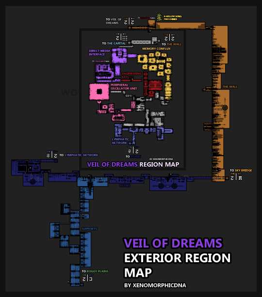
Map boi is back with more map
This time it's the ★exterior★
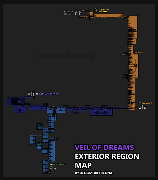
It's not as nice looking as the interior, (which you can find → here btw) but i think it's bigger as a region.
I will be making at least one more, and it will be of Two Birds' can because it's got lots of rot bits and that sounds like fun to design.
Pearl dialogue and some rambles below the cut↓
I know I said dialogue but fr look at this
THE DIFFERENCE in canvas size here
Pearl dialogue for both of the two regions
Bright Pink pearl dialogue when read by Veil Of Dreams:" What is it Mouse? Oh a pearl, alright I'll have a look. Ah this one is one of mine, it contains various notes regarding Four Blue Flames when he was still being constructed. It was actually a personal request of mine to have him built, his technology is better than mine in practically every way and he makes for a great research partner. I admire his work ethic, but I do wish he took breaks. After our creators' Ascension he's only become more wrapped up in the Great Problem, I worry for him. ... There is nothing more on this pearl that would interest you, you can have it back, I do not need it."
Bright Pink pearl dialogue when read by Four Blue Flames: "Hello Mouse, a pearl? Let's have a look. Hm, where did you find this? It's encrypted so I cannot read it to you, but I can guess that it was written by one of us. Unfortunately, I am of no use to you, but if you like pink then the pearl would make for a great decoration. Or alternatively, you can trade it to the scavengers. Of course, they will ruin the pearl like they do with the rest but if you are in need of explosives the scavengers excel in their creation. Now if you do not mind, allow me to get on with my work."
Deep Red pearl dialogue when read by Veil Of Dreams: "Rodent, you've got a pearl, allow me to read it for you. Oh, this one holds digital copies of several pieces of literature, I was missing many of these from my memory banks. I have them saved now, but I do not like the implications of this. Please Mouse, take the pearl and bring it to the library in the Capital."
Deep Red pearl dialogue when read by Four Blue Flames: "Oh a pearl, let's see what it says. This one is filled with all sorts of religious literature, it's rather old, from the Green hegemonic linguistic dynasty. It contains texts for meditation and prayers and various forms of religious guidance. I actually did not have this archived, so I appreciate your fondness of treasure hunting, you are a great help. I think this one would fit nicely in the Capital's library, please, bring it to Veil Of Dreams and he will guide you from there."
#MAAAN THESE TAKE SO LOOOON#i will make more#i would actually have echo dialogue bUUUt i havent thought of anything so uhh ye#also some people asked how i made the map on the last post and its honestly just done on a small canvas on my usual drawing#program. Just turn off anti-aliasing and set brush size to 1 and start drawing. The background is just black with like 50% opacity and then#there is the colour layer under all that. No fancy program or anything :>#embrace massive supercomputer and design the entire structure ya cowards/j#the exterior would be fairly safe tbh i mean there might be the occasional spider and maybe a white lizard or two#but the main threat would be uuuuh a lot of miros vultures- so actually maybe not that safe#but mouse does get a citizen id drone later and both mouse and fish get put on a sorta “no kill” list by veil of dreams#dreams loves his birds oh he has so many around his structure its not even funny#rain world#iterator#rain world oc#iterator oc#oc veil of dreams#drawins
55 notes
·
View notes