#mike lucibella
Explore tagged Tumblr posts
Visit Tumblr Blog
Explore Tumblr blogs with no restrictions, modern design and the best experience.
Last Seen Tumblr Blogs


Fun Fact
BuzzFeed published a report claiming that Tumblr was utilized as a distribution channel for Russian agents to influence American voting habits during the 2016 presidential election in Feb 2018.
Photo

Crabeater seal at Palmer Station
A crabeater seal lounging at Palmer Station, Antarctica. Despite their name, crabeater seals only eat Antarctic krill and use their specially shaped teeth to filter out the seawater.
Credit: Mike Lucibella/NSF
#mike lucibella#photographer#national science foundation-ocean observatory initiative#crabeater seal#seal#animal#mammal#arctic national wildlife refuge#palmer station#antarctica#antarctic krill#nature
243 notes
·
View notes
Text
The Forgotten American Explorer Who Discovered Huge Parts of Antarctica
https://sciencespies.com/nature/the-forgotten-american-explorer-who-discovered-huge-parts-of-antarctica/
The Forgotten American Explorer Who Discovered Huge Parts of Antarctica

The early-1900s exploits of intrepid explorers like Robert Scott and Edward Shackleton captured the public imagination. With the benefit of cameras and deft handling of newspaper media, the Edwardian British explorers, alongside their Norwegian rival Roald Amundsen, established themselves as heroic polar pioneers. In the process, however, the south polar exploits of their American forerunner, Charles Wilkes, have been largely forgotten.
It was the round-the-world expedition by Wilkes—whose scientific collection constituted the first treasures of the infant Smithsonian—that first established the continental dimensions of Antarctica. But in a twist of 19th-century international politics, that claim to Antarctica was denied to the Americans by the pole-hungry British. Fast forward to today, and the United States finds itself in another nationalistic race to capitalize on the frozen southern continent. This time, its sparring partner is China.
Amundsen might have been the first man to reach the South Pole, in 1911, but the discovery of the Antarctic continent occurred several generations earlier. In January 1840, when Wilkes was commander of the United States Exploring Expedition, he charted 1500 miles of the east Antarctic coastline in his flagship U.S.S. Vincennes. Before this American expedition, only small, rocky outcrops of Antarctica had been sighted. Most exploreres believed an open polar sea or, at most, a scattered archipelago lay at the planet’s far south.
In a remarkable coincidence, a French expedition led by the legendary Jules Dumont D’Urville reached the same stretch of coastline on the same day. But D’Urville stayed just long enough to plant the French flag on a tiny offshore island before sailing back north. Wilkes, meanwhile, against the advice of his medical staff and officers, braved the cold, ice, and howling katabatic winds to claim glory for the Vincennes.
Charles Wilkes barely had time to announce his Antarctic triumph before British rival James Clark Ross (celebrated discoverer of the North Magnetic Pole) began to steal his thunder. Wilkes’s mistake was to send the lagging Ross his historic first chart of the east Antarctic coast. A year later, when Ross retraced Wilkes’s route, he found the American had been deceived in places by glacial reflections and had mistaken ice shelves for actual coastline, marking it several degrees too far north. These errors did nothing to undermine the substance of Wilkes’s discoveries, yet Ross and the British Admiralty built a public case against the American claim—with great success. Most 19th-century maps of Antarctica do not recognize Wilkes’s remarkable 1840 feat. Even his obituaries in American newspapers made only passing mention of Wilkes’ polar discoveries.


Lieutenant Charles Wilkes, commander of the United States Exploring Expedition, 1838 to 1842
(Thomas Sully, U.S. Naval Academy Museum)
In the 20th century, Wilkes would finally get his due. In 1912-13, Australian explorer Douglas Mawson was the first to revisit the east Antarctic shores mapped by the Vincennes. Mawson so admired Wilkes’ navigation of the ice pack in a wooden sailing ship that he christened the entire coast “Wilkes Land,” which remains the largest continuous territory on Earth named for a single individual.
Wilkes’ rehabilitation reflected the changing power dynamics of the polar great game. The British and French eventually ceded the argument, and corresponding territory, to the United States as the world’s emerging polar power. During the Cold War, the United States continued to assert its leadership in Antarctic affairs, brokering the international Antarctic Treaty of 1958 and investing in cutting-edge polar research. Much of what we know about climate change, for instance, comes from secrets revealed in drilling Antarctic ice cores, an outgrowth of America’s interest in polar science.
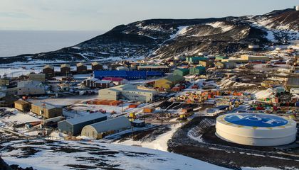
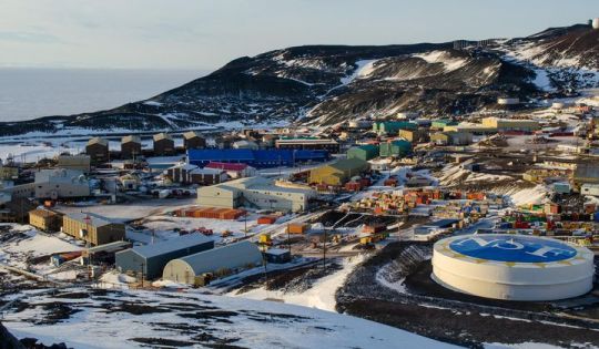

2015 photograph of McMurdo station, Antarctica
(Mike Lucibella, NSF)
Today, the Antarctic landscape is changing—and not just from melting glaciers. America’s interest in Antarctica appears to be waning, and so too is its influence.
In the decade following the 2008 global recession, funding for the Office of Polar Programs, which oversees American facilities and research in Antarctica, fell by 8 percent. Plans for the long-overdue replacement of aging facilities at McMurdo Station, the United States’ Antarctic headquarters, were drawn up during the Obama administration, but a further proposed cut of more than 10 percent in the 2021 budget places those rebuilding plans in jeopardy just as work is set to begin. Without modernization of McMurdo, which in its size and sophistication has long been the envy of other nations, the perception of America’s declining interest in Antarctica will grow.
China, long relegated to spectator status in Antarctic affairs, stands to gain the most. With four Antarctic stations already, China is now in the advanced planning stages for a fifth station—this one to be located in the heart of “downtown” Antarctica, on an island in the Ross Sea adjacent to McMurdo. The image of a rusting, outdated American station alongside a gleaming, state-of-the-art Chinese facility will communicate more clearly than a hundred polar policy papers the reality of the power transfer already under way in Antarctica, where China’s investments in icebreakers, communications hardware, and station infrastructure dwarfs that of other nations, including the United States.

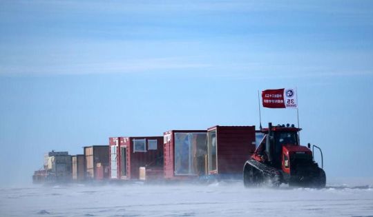

China’s 35th Antarctic expedition sends 37 members of two inland expedition teams to the Kunlun and Taishan stations in Antarctica Dec. 18, 2018.
(Xinhua News Agency / Getty Images)
The French, British, and American expeditions of the 1840s sailed south in the hope of discovering a Terra Australis laden with mineral treasures, only to find towering glaciers and deathly cold. A couple of centuries later, it’s China that is determined to reap Antarctica’s mineral riches.
As the northern ice melts, the Arctic Ocean is already the scene of international jockeying for mining rights. But as China scholar Anne-Marie Brady has documented extensively, Beijing views Antarctica as the last great terrestrial frontier on Earth, hosting great deposits of coal, natural gas, precious minerals, added to plentiful fish stocks in the surrounding ocean and even vast freshwater reserves locked up in Antarctic ice. China intends to exploit the continent fully once the current Antarctic Treaty expires in 2048, if not sooner. With nations hungry for new sources of oil and mineral wealth, and China laying the groundwork for industrialization of the pole, the stakes for Antarctica couldn’t be higher.
An obvious irony looms over this new Antarctic rush. If Antarctic glaciers are already melting, and the consequent sea-level rise threatens to inundate coastal cities across the globe, why would any government make plans to exacerbate global warming by exploiting fossil fuel reserves in Antarctica? Will the 21st century end with oil fields in an ice-free Wilkes Land or strip-mining in the forested Transantarctic Mountains that are currently buried in ice? It seems outlandish, but this is exactly the future that Beijing’s plan could trigger, even if public pronouncements from China conform to the diplomatic polar language of international collaboration and disinterested scientific research.
As the nation with the greatest historical investment in Antarctica, the U.S. has the resources and authority to lead an international re-commitment to south polar conservation. By reaffirming its leadership role at the pole, America can ensure that the great game of the 21ar century does not repeat the mistakes of those of centuries prior, when the world’s pristine frontiers were fought over and ransacked with little thought for environmental damage, or for what future human generations might do once the last wilderness on Earth melts away.
This story is adapted from the author’s new book Land of Wondrous Cold: The Race to Discover Antarctica and Discover the Secrets of its Ice.
#Nature
#03-2020 Science News#2020 Science News#Cannon#Earth Environment#earth science#Environment and Nature#Nature Science#News Science Spies#Our Nature#outrageous acts of science#planetary science#Science#Science Channel#science documentary#Science News#Science Spies#Science Spies News#Space Physics & Nature#Space Science#Nature
1 note
·
View note
Photo

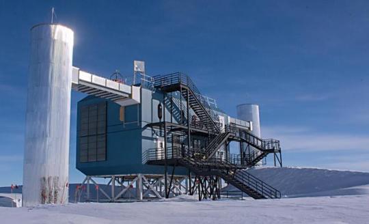


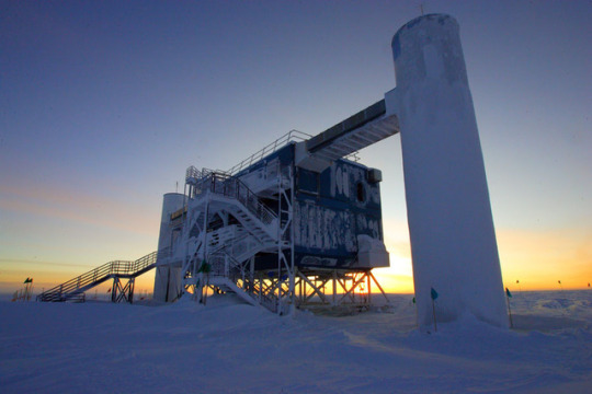


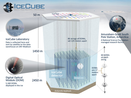
IceCube ( IceCube Neutrino Observatory)
IceCube, the South Pole neutrino observatory, is a cubic-kilometer particle detector made of Antarctic ice and located near the Amundsen-Scott South Pole Station. It is buried beneath the surface, extending to a depth of about 2,500 meters. A surface array, IceTop, and a denser inner subdetector, DeepCore, significantly enhance the capabilities of the observatory, making it a multipurpose facility.
IceCube is the first gigaton neutrino detector ever built and was primarily designed to observe neutrinos from the most violent astrophysical sources in our universe. Neutrinos, almost massless particles with no electric charge, can travel from their sources to Earth with essentially no attenuation and no deflection by magnetic fields.
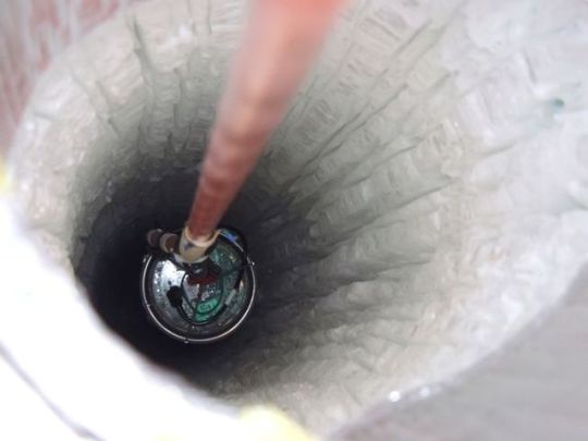
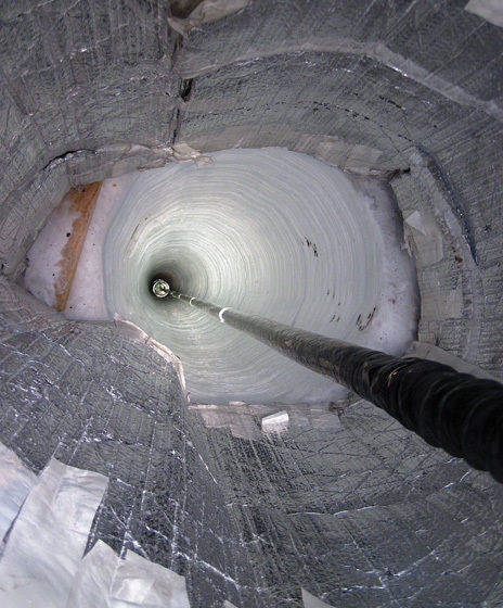
The in-ice component of IceCube consists of 5,160 digital optical modules (DOMs), each with a ten-inch photomultiplier tube and associated electronics. The DOMs are attached to vertical “strings,” frozen into 86 boreholes, and arrayed over a cubic kilometer from 1,450 meters to 2,450 meters depth. The strings are deployed on a hexagonal grid with 125 meters spacing and hold 60 DOMs each. The vertical separation of the DOMs is 17 meters.
Eight of these strings at the center of the array were deployed more compactly, with a horizontal separation of about 70 meters and a vertical DOM spacing of 7 meters. This denser configuration forms the DeepCore subdetector, which lowers the neutrino energy threshold to about 10 GeV, creating the opportunity to study neutrino oscillations.
IceTop consists of 81 stations located on top of the same number of IceCube strings. Each station has two tanks, each equipped with two downward facing DOMs. IceTop, built as a veto and calibration detector for IceCube, also detects air showers from primary cosmic rays in the 300 TeV to 1 EeV energy range. The surface array measures the cosmic-ray arrival directions in the Southern Hemisphere as well as the flux and composition of cosmic rays.
Developments in neutrino astronomy have been driven by the search for the sources of cosmic rays, leading at an early stage to the concept of a cubic-kilometer neutrino detector. Cosmic rays, which consist mainly of protons, are the highest energy particles ever observed, with energies over a million times those reached by today’s particle accelerators on Earth.
AMANDA, the Antarctic Muon and Neutrino Detector Array, was built as a proof of concept in the mid 1990s and demonstrated that the extremely clear Antarctic ice was suitable for detecting energetic neutrinos. IceCube, the only cubic-kilometer neutrino detector constructed to date, was completed in December 2010, only six years after the deployment of the first string at the South Pole.
Neutrinos are not observed directly, but when they happen to interact with the ice they produce electrically charged secondary particles that in turn emit Cherenkov light, as a result of traveling through the ice faster than light travels in ice.
The IceCube sensors collect this light, which is subsequently digitized and time stamped. This information is sent to computers in the IceCube Lab on the surface, which converts the messages from individual DOMs into light patterns that reveal the direction and energy of muons and neutrinos.
The IceCube Neutrino Observatory was built under a National Science Foundation (NSF) Major Research Equipment and Facilities Construction grant, with assistance from partner funding agencies around the world. The NSF Office of Polar Programs supports the project with a Maintenance and Operations (M&O) grant. The University of Wisconsin–Madison is the lead institution, coordinating data-taking and M&O activities. The international IceCube Collaboration, with more than 40 institutions worldwide, is responsible for the scientific research program.
Source: icecube.wisc.edu Images: iceCube/NSF,Mike Lucibella, Sven Lidstrom, Jim Haugen, B. Gudbjartsson.
#neutrino#neutrinos#particle#particula#fisica#physcis#astrophysics#astrofisica#icecube#antarctica#antartida
3K notes
·
View notes
Photo
New Post has been published on https://usviraltrends.com/u-s-u-k-science-armada-to-target-vulnerable-antarctic-ice-sheet-science/
U.S.-U.K. science armada to target vulnerable Antarctic ice sheet | Science
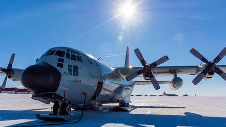
Planes, ships, and submersibles: Operating on the Thwaites glacier will require a heavy logistic lift from the United States and the United Kingdom.
Mike Lucibella/U.S. National Science Foundation U.S. Antarctic Program
By Paul VoosenApr. 30, 2018 , 6:00 AM
An armada of 100 scientists will soon be descending on West Antarctica, and understanding the future of global sea levels might depend on what they find. Today, after several years of planning, the U.S. and U.K. science agencies announced the details of a joint $50 million (or more) plan to study the Thwaites glacier, the Antarctic ice sheet most at risk of near-term melting.
The International Thwaites Glacier Collaboration plans to deploy six teams to the remote ice sheet, where they will study it using a host of tools, including instrument-carrying seals and earth-sensing seismographs. The researchers will concentrate their work in the Antarctic summers of 2019–20 and 2020–21. An additional two teams will channel the findings of the field teams into global models.
Overall, the collaboration is the largest joint effort between the two nations in Antarctica since the 1940s. “We’ll see what until now has been inferred playing out right in front of our sensors,” says Ted Scambos, a glaciologist at the National Snow and Ice Data Center in Boulder, Colorado, who is serving as the lead U.S. scientific coordinator.
Over the past decade, thanks to a variety of satellite and aircraft observations and modeling insights—including signs that the glacier’s ice has started thinning and flowing faster toward the ocean—scientists have been paying special attention to Thwaites. It is, they believe, the Antarctic ice sheet most at risk of accelerated melting in the next century, making it the wild card in projections of sea level rise. But its remote location, 1600 kilometers from the nearest research station, has made it inaccessible to scientists seeking to understand these risks up close.
Thwaites, a 182,000-square-kilometer glacier in the Amundsen Sea, acts as a plug, blocking the rest of the West Antarctic Ice Sheet from flowing into the ocean. Melt from the glacier already accounts for 4% of modern sea level rise, an amount that has doubled since the 1990s. Scientists are concerned that if it retreats, it could become unstable, making the collapse of the ice sheet irreversible and ultimately increasing sea levels by 3.3 meters over the span of centuries or millennia.
“It could contribute to sea level in our lifetimes in a large way, in a scale of a meter of sea level rise,” says Sridhar Anandakrishnan, a glacial seismologist at Pennsylvania State University in State College who is co-leading one Thwaites project. “Which is just an unthinkable possibility.”
Over the past decade, the Thwaites glacier has risen to the forefront of scientists’ Antarctic melt concerns.
Jeremy Harbeck
Overall, the U.S. National Science Foundation and the United Kingdom’s Natural Environment Research Council will spend $25 million on the science, with each of the eight teams led by researchers from both countries. Funders expect to spend another $25 million or more on the logistics of moving so much heavy equipment toward the shelf. Several ships will work off the coastline while scientists will be based at the former drilling site of the West Antarctic Ice Sheet Divide ice core, flying from there to their research sites in small airplanes or helicopters.
The scientific teams will focus on what puts Thwaites particularly at risk. Researchers have noticed that shifts in winds seem to be pushing warm, deep ocean waters on to Antarctica’s continental shelf at the base of its glaciers. Thwaites is perched on a ridge that holds these waters back, but beyond that ridge, the land under the glacier slopes downward, creating an inland bowl that is below sea level. But the researchers are uncertain about the composition and slipperiness of that geologic bowl.
One study, co-led by Anandakrishnan, will seek to understand the actual composition of the bowl and a second ridge, 70 kilometers inland, on which the glacier might catch. “In some models [the melting glacier] stabilizes” on that ridge, Anandakrishnan says. “In some it doesn’t.” By detonating explosives on the surface of the ice sheet and using seismic sensors to measure their reflections, his team will tease out whether the rock underlying Thwaites, including this critical ridge, is soft and pliable or hard and crystalline.
Another project will target the warm intruding waters. “We plan to have a pincer movement,” says Karen Heywood, an oceanographer at the University of East Anglia in Norwich, U.K., who will be co-leading the team. One effort will involve drilling sensors through the ice and then driving several autonomous submersibles and gliders toward these stations. Another, starting this year, will involve outfitting 10 seals a year with scientific instruments, using the animals to make routine, repeated studies of the ocean. The technique that should produce a torrent of sustained data. They’ll be running similar measures on the nearby Dotson Ice Shelf, seeking to understand whether differences in the ocean waters explain why Thwaites is retreating so rapidly compared with Dotson.
Scientists also expect to explore the glacier’s grounding zone, planning to drill through 800 meters of ice to observe over several seasons where the triangle of ice, ocean, and rock meet. That will include dropping a new autonomous vehicle, developed by the Georgia Institute of Technology in Atlanta, that can deploy through a borehole and explore the grounding zone—an unprecedented view.
Other projects will seek geological evidence of whether Thwaites has previously retreated and reformed in the past 10,000 years, giving a clue to whether the modern melting threat is truly unprecedented. And another team will examine the glacier’s connections to the broader ice sheet—its shear margins—using radar and seismic reflections to detect whether neighboring ice helps hold it in place or lets it go, like a game of high-stakes red rover.
For now, the researchers are eager to get started. The United States and United Kingdom announced the opportunity almost a year and a half ago and it took some time to come together. This project is expected to launch a new generation of Antarctic researchers and, in the process, might reduce some uncertainty about the future of climate change. “No doubt we’re going to learn something that’s important to refining those predictions,” Scambos says. “This is kind of the missing piece right now.”
0 notes