#sinkyone wilderness state park
Text

In the Shady Dell forest in Sinkyone Wilderness State Park, many of the ancient redwoods are shaped like candelabras. Whereas redwoods typically grow straight up, stressors caused these trees to sprout branches near the ground that droop like velvet ropes in a theater. Then when conditions improved, the branches grew straight up. The 2.3-mile Peter Douglas Trail, created in 2016, provides access to these amazing trees.
16 notes
·
View notes
Text

The Candelabra tree at Shady Dell in the Sinkyone Wilderness State Park North of Fort Bragg and Mendocino on the North Coast. The 957-acre dell is home to a mystical grove of the ancient candelabra-shaped redwoods.
Photo by Mike Shoys
0 notes
Photo
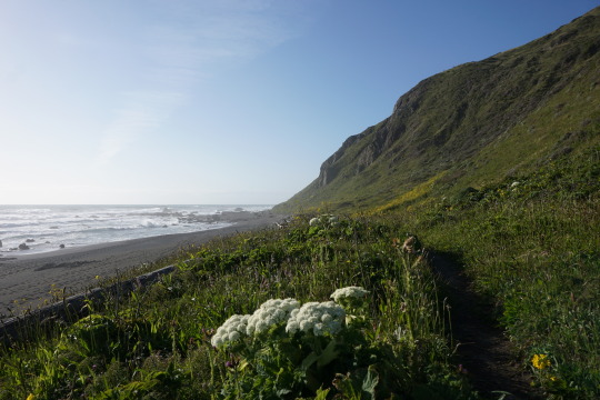


Lost Coast Trail, California
Beautiful wildflowers and rain showers along the 1st half through King Range National Conservation Area (#1-4) followed by dense forests and coastal cliffs along the 2nd half through Sinkyone Wilderness State Park (#5-10)
#lct#lost coast trail#lost coast#backpacking#hiking#camping#views#landscapes#nature#wildflowers#sinkyone#king range#sinkyone wilderness state park#king range national conservation area#california#spring
36 notes
·
View notes
Photo

A tree in Yemen

Boabab tree in Madagascar photo by @maguzman83

Bulbous red cedar

The Thinking Tree, an ancient olive tree in Puglia, Italy

The candelabra tree at Shady Dell in the Sinkyone Wilderness State Park
1K notes
·
View notes
Text

The candelabra tree at Shady Dell in the Sinkyone Wilderness State Park north of Fort Bragg and Mendocino on the North Coast. The 957-acre dell is home to a mystical grove of the ancient candelabra-shaped redwoods 📷 Mike Shoys taken from the Save the Redwoods League book "The Once and Future Forest: California's Iconic Redwoods"
144 notes
·
View notes
Text
Sinkyone Wilderness State Park
So, I don’t want to brag…but I found the best state park in California. I considered not sharing and keeping the pristine, remote wilderness to myself. But Sinkyone Wilderness State Park is so far off the beaten path that I don’t think I need to worry about it getting overrun. Sinkyone Wilderness State Park is one of the few ways to access the Lost Coast – California’s least developed stretch of…
View On WordPress
#beaches#best beaches california#black sand beaches california#california coast road trip#camping#driving to lost coast#elk#harbor seals#hiking#lost coast#lost coast california#needle rock visitor center#north coast road trip#northern coast camping#otters#road trips#seals#sinkyone#sinkyone wilderness state park
0 notes
Video
instagram
360* view of Wheeler Beach. •Sinkyone State Park • #findout #backpacking #camping #lostcoasttrail #lostcoast #sinkyonewilderness #wheelerbeach #wheeler #camp #stateparks #california #californiadreaming #californialove (at Sinkyone Wilderness State Park)
#camp#lostcoast#california#californiadreaming#findout#californialove#lostcoasttrail#camping#wheelerbeach#backpacking#wheeler#sinkyonewilderness#stateparks
0 notes
Text
On California’s Lost Coast: Sea Lions, Surf and Squiggly Roads
On a deserted beach in Northern California, I mistook a sea lion for driftwood. The Lost Coast is deceiving that way. Wild things appear tame and tame things, like the paved road my family and I took to get here, wild.
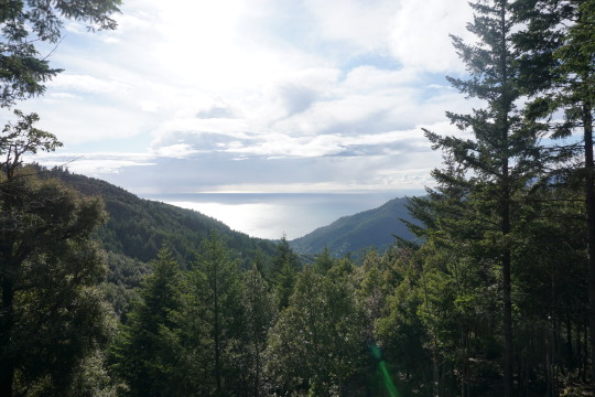
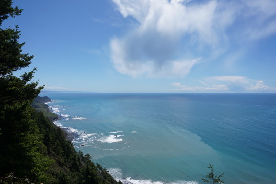
In June, seeking immersion in nature, we visited the Lost Coast, the largely roadless shore between the indiscernibly tiny town of Rockport and the Victorian charmer Ferndale, about 100 miles apart by inland roads. Here in Humboldt County, California reaches its westernmost point near a junction of three seismically active tectonic plates. The King Range mountains plunge into the sea, deterring road-builders from continuing State Route 1 along the ocean. Breaking waves strew driftwood along beaches reached by hiking trails that require consulting a tide chart. It’s cold and foggy, even in summer, and just rough enough to keep all but the most intrepid day-trippers away.
“No one comes here without intending to come here,” said Verna Kaai, the manager of the Tides Inn, a homey base in Shelter Cove, the oceanfront gateway to the Lost Coast, when I booked a room for three days amid a weeklong road trip. “We’re only about 20 miles from the highway,” she said of the squiggly access road that connects the town to the nearest thoroughfare, “but it will take you up to an hour to travel.”
That sounded like our speed. And while the coast wasn’t lost to the Native Americans, loggers and cannabis growers who have left their mark here, it appealed to us in another escapist sense: little connectivity. Ms. Kaai assured me I wouldn’t have cellular service, though the hotel had very slow Wi-Fi. In this screen-centric age, a few scenic and relatively unwired places remain in the United States, such as Organ Pipe Cactus National Monument in southern Arizona and parts of the Adirondack Mountains in New York. But this slice of California’s coast — only some 225 miles north of San Francisco — seems, well, lost in plain sight.
A harrowing drive
Long before it went missing, the area was populated by Native American Sinkyone and Mattole people, and later, lumberjacks and harvesters of tanoak bark, used to tan leather. The Gold Rush in the mid-19th century brought more settlers, and logging intensified in the race to rebuild the city after the San Francisco earthquake in 1906. Churning seas tended to wash out piers, which killed most attempts to fish commercially in the 19th and 20th centuries. In 1970, after the timber industry had depleted much of the area, and depopulation drew pot growers, the 68,000-acre King Range National Conservation Area, which protects 35 miles of coast and mountains up to 4,088 feet, became the country’s first National Conservation Area.
Now, visitors come to the Lost Coast to hike, fish, beachcomb, bird-watch and scan the ocean for migrating whales in the offshore marine preserve (Ms. Kaai recommended visiting on a weekend, when Shelter Cove’s few restaurants are open). Others come to backpack along the famous Lost Coast Trail-North, a nearly 25-mile beach trek that generally takes three days, requires a permit (free, with a $6 reservation fee) and is subject to tides that periodically make portions impassable.
Like the hiking here, driving to reach the Lost Coast requires a degree of fortitude. The builders of California’s Highway 1, which skirts the Pacific from Orange County more than 600 miles north, gave up the shore plan at the King Range, a topographic accordion we glimpsed in hazy fog and spray before veering inland. It ends at Leggett, about 15 miles from the ocean, funneling drivers onto U.S. 101, which continues north through southern Humboldt County before rejoining the coast near Eureka.
From the U.S. 101 exit at Garberville, 23 miles from Leggett, the route to Shelter Cove turned westward and challenging. For the next 50 minutes of concentrated driving, my husband, Dave, worked hard to maintain 35 miles per hour winding up mountain ridges and through dense fir forests, and downshifting at the continuous switchbacks to avoid overheating the brakes. Past the town limit sign for Shelter Cove, population 809, I finally relinquished my clutch on the Jeep door handle at the ocean panorama of surf-bashed rock islands and mountain-backed beaches.
Shelter Cove, at last
On the southern end of the Lost Coast Trail-North, Shelter Cove is scattered across a largely treeless peninsula that protects the town’s namesake, a south-facing cove. A general store on the access road deals groceries and hardware in the absence of any commercial main street in town. Modest houses dot the shore, leaving plenty of gaps for places with names like Seal Rock and Abalone Point, and views to the sea from most vantage points, including a campground and a lightly used nine-hole golf course. The closest thing to a town square is the community center, which, when we visited, was holding a group garage sale near the landing strip that parallels the coast.
Between the runway and the sea, the location of the eight-room Tides Inn — a three-story cross between a motel and a McMansion that is perched above a cove and hugged by rocky arms — exceeded our expectations. Our suite was thoughtfully furnished with nautical décor in the bedroom, a kitchenette nook with a mini-refrigerator and microwave and a high-top dining table. But the views made you forget about anything indoors. From our third-floor balcony, we could hear sea lions barking each morning and watch sunsets late each evening.
While it remains a destination for lovers of isolation, Shelter Cove has added a few tourist-friendly essentials in the past year, including a brewpub and a Venezuelan restaurant, Mi Mochima. On our first night, we followed the music across a ball field and skirted the unfenced landing strip to find Gyppo Ale Mill, a microbrewery, which takes its name from independent timber crews who came to Northern California to fell big trees (some logging remains, though environmental activists are fighting to preserve one of the region’s remaining old-growth Douglas fir stands, known as Rainbow Ridge). On this Friday night, the local band Planet 4 played funky tributes to Dr. John, who had recently died, and children ran circles around a cornhole-playing field.
Like us, the Gyppo Ale Mill’s co-owner Julie Peacock took one of the dramatic drives to the Lost Coast region and immediately fell in love with it. In 2001, she and her husband, Josh Monschke, whose family has roots in Humboldt County logging, left ski resort jobs in Utah to move to the area to farm marijuana, and he continues to run a nursery. They opened Gyppo last spring and call it “California’s most remote brewery,” because, said Ms. Peacock, “I haven’t found one more remote.”
We felt we’d earned an I.P.A. or two, after the harrowing drive in, but learned that’s not an excuse used by residents.
“Locals think nothing of driving that road to town,” said Katie Wallace-Schmidt, the manager of Gyppo as she delivered falafel burgers and lamb sausage to our table. “In L.A., I could easily be on the highway for 50 minutes to go 10 miles. I’d much rather be here.”
A dose of wilderness therapy
Given the weather, which generally peaks in the 60s in summer, we didn’t consider Shelter Cove a swim destination, though we found hardy bathers dipping into the shallows at Cove Beach on Saturday morning. By afternoon, a dozen SUVs and pickup trucks were parked on the popular beach, a rare safe place to swim along the Lost Coast, which is known for its rip currents and shore-breaking waves.
If not a traditional beach-lovers’ shore, the Lost Coast is ideal for losing time climbing over craggy rocks and inspecting tide pools. Between hikes in the conservation area, we scrambled around the peninsula’s rough edges, watching whistling oystercatchers, turkey vultures with their wings spread to dry in the sun, and sleepy harbor seals, some of them still pale in their juvenile coats (a notice posted in the Tides Inn window warned visitors from getting close to the pups, which are often alone and mistaken for orphaned while their parents, who may abandon their babies if in the presence of humans, are out fishing).
The Bureau of Land Management, which oversees the King Range preserve, allows 60 overnight backpackers per day to depart on the Lost Coast Trail-North between May 15 and Sept. 15 (30 people per day are permitted the rest of the year, when worsening weather notoriously alters and sometimes washes out parts of the trail). Day hikers do not need a permit. On our visit, the Shelter Cove trailhead parking lot was full, with more than two dozen cars, and a nearby street was lined with the overflow, indicating the numbers of hikers somewhere along the coast. Still, we felt we had the trail to ourselves Saturday morning, along with a black bear, possibly, based on the fresh scat we encountered.
From the Shelter Cove trailhead at Black Sands Beach, the going was slow on spongy black sand and tumbled sandstones that were hard to grip as our boots sank inches with each step. The slow pace that beach hiking enforced worked as wilderness therapy. We combed the high-tide line, finding patterned sea urchin shells, sun-bleached sea stars, driftwood sanded by waves and the occasional crab trap. Near the breaking surf, we nearly bumped into a juvenile sea lion we mistook for a log. We took breaks atop 20-foot high boulders that appeared to have tumbled from a mountain peak with an evident rock slide on its oceanfront face (the offshore Mendocino Triple Junction sets off frequent tremblers in an area where the three tectonic plates meet). Massive timbers made sturdy bridges to cross mountain streams that run down the slopes and cut through the sand on their way to the sea.
Venezuelan fare, blind curves and a tiny lighthouse
That night we gorged at Mi Mochima, a sunny new Venezuelan spot with its own boomerang story. The married owners, Blu Graham and Maria Graham Diaz, met in Venezuela where he was a scuba-diving guide. In 2011, after moving back to the coast where he grew up, Mr. Graham opened the neighboring Lost Coast Adventure Tours, which offers guided backpacking trips on the trail. The ocean-view A-frame restaurant, where Ms. Diaz is the chef, is designed to balance out their seasonal business, offering mini fish empanadas, garlic-sautéed prawns and a hearty shredded beef stew known as pabellón criollo. Our waitress, the couple’s adult daughter, Indiana Graham, explained that the coastal town of Mochima, Venezuela, and Shelter Cove are only distant in a geographic sense.
“They both are all about the ocean,” she said.
Getting to the northern trailhead at the Mattole River the following day was the most extreme of our adventure drives. Our innkeepers recommended a paved route largely outside of the conservation area that still turned out to be a hair-raising, one-hour, 40-minute errand on narrow roads that occasionally pinched to one lane, often, it seemed, just as we reached a blind curve (Lost Coast Adventure Tours, also offers shuttle service to the trailhead in 11-passenger vans).
A series of determined roads ascended pine-dense hillsides, undulated over mountain passes of wildflower meadows and tunneled through trees, only to descend and make the climb all over again. The few towns indicated on the map were easy to miss, though the general store in Honeydew, a blink of a town where a few intriguing back roads intersect, was thronged with dirt bikers on a group drive. We passed through sleepy Petrolia, site of the first oil well drilled in California, and took the relatively flat Lighthouse Road that follows the tail end of the Mattole River to reach the Lost Coast Trail at its top end.
In contrast to the pine forests around the southern trailhead at Shelter Cove, grassy woodlands border the northern gateway. Desert wildflowers, including globe-shaped yellow sand verbena, daisylike purple fleabane and violet lupine, bloomed in the dunes. A deer grazed a hillside and sea lions on offshore rocks barked at our approach. At just over three miles in, a colony of elephant seals dozed below the squat, white Punta Gorda Lighthouse, a remote, long-decommissioned beacon anchoring a grassy hillside above the shore.
Leaving the Lost Coast northbound saves one of the best adventure drives for last when, past Petrolia, two-lane Mattole Road links to the coast again and follows an undeveloped stretch. Bushy wild radish plants crowded the road as it climbed inland and, 90 minutes later, abruptly disgorged us in Ferndale, a manicured Victorian-era Mayberry. There, a ukulele ensemble was jamming in a bank parking lot, a comparatively found spot — with cellular service restored — at the border of the lost wilds.
Elaine Glusac is a frequent contributor to the Travel section.
52 PLACES AND MUCH, MUCH MORE Follow our 52 Places traveler, Sebastian Modak, on Instagram as he travels the world, and discover more Travel coverage by following us on Twitter and Facebook. And sign up for our Travel Dispatch newsletter: Each week you’ll receive tips on traveling smarter, stories on hot destinations and access to photos from all over the world.
Sahred From Source link Travel
from WordPress http://bit.ly/30KSLQV
via IFTTT
0 notes
Photo


Hardy Creek Beach, CA
Hardy Creek Beach in Mendocino County is located where Highway 1 turns inland and heads north never to return to the coast. The beach is in a small cove where Hardy Creek flows down from the hills behind it. Winter waves have pushed driftwood and larger drift logs up to the back of the cove. Many photographic rocks stand tall in the surf. South of the beach is Hardy Rock which is shaped like a shark fin and has a rock arch that is visible when viewed from the highway near the rock. North of the beach there are several more towering sea stacks. There is a narrow parking area right at the bend in the highway. A steep trail drops straight down to the beach from this spot. A “no trespassing” sign half-way down this trail probably scares off those that weren’t already turned back by the steep access. The coastline north Hardy Creek gets very rugged so the highway turns inland and follows a safer route north from here. That creates a vast wild area with no highway passing through it. This area is known as The Lost Coast and is largely protected by Sinkyone Wilderness State Park.
Source
#Hardy Creek Beach#pacific ocean#seascpae#cliff#fog#grass#nature#countryside#waves#original photography#summer 2017#rock formation#California#usa#west coast#flower#blooming#seagull#cormorants#close up#travel#vacation#road trip#landscape#view#sand
0 notes
Photo

When I asked the ranger for a good, scenic, primitive camping spot, he replied: “Site #3 is the best. There are no trails leading to the campsite. It’s perched among the bushes on top of a bluff looking towards the ocean and might get windy but it’s THE BEST”. It became a mission to find the site. No trails and had to climb straight up a bluff through some steep grassy slope and there it was. . The views of the #LostCoast was spectacular indeed. Just as we finished pitching the tent to watch sunset, a herd of Elk, about 50-60 of them, paid a visit to our campsite and they were chilling around all evening. . 🏕🦌 🌊 🌅 . At $5/person, this is one of the best camp site I have ever stayed in. #Sinkyone wilderness, ‘twas a real #wilderness experience. . #billionstarhotel #takethetrail @bedrocksandals #lostcoast #hiking #backpacking #adventures #rei1440project #optoutside #trailchat #trailrunning #california @furtherfasterforever (at Sinkyone Wilderness State Park)
#wilderness#takethetrail#billionstarhotel#backpacking#hiking#trailchat#lostcoast#sinkyone#trailrunning#3#adventures#optoutside#california#rei1440project
0 notes
Video
undefined
tumblr
Lost Coast Trail, Northern Section Timelapse 2
#lct#lost coast trail#lost coast#backpacking#hiking#camping#views#landscapes#nature#sinkyone#sinkyone wilderness state park#king range national conservation area#timelapse#california#spring
2 notes
·
View notes
Video
undefined
tumblr
Lost Coast Trail, Northern Section Timelapse 1
#lct#lost coast trail#lost coast#backpacking#hiking#camping#views#landscapes#nature#sinkyone#king range#sinkyone wilderness state park#king range national conservation area#timelapse#california#spring
1 note
·
View note
Photo

"Of all the paths you take in life, make sure a few of them are dirt." - John Muir • Lost Coast Trail, Sinkyone Wilderness State Park, Mendocino county, California. • 📷 by @joeytwelve. • #californiadreaming #californialove #california #camping #backpacking #hiking #johnmuir #thelostcoast #lostcoast #lostcoasttrail #thelostcoasttrail #sinkyone #sinkyonewilderness #sinkyonewildernessstatepark #mendocino #mendocinocoast #findout (at Sinkyone Wilderness State Park)
#thelostcoast#californialove#camping#mendocinocoast#findout#lostcoast#mendocino#johnmuir#californiadreaming#california#hiking#lostcoasttrail#thelostcoasttrail#sinkyone#sinkyonewildernessstatepark#sinkyonewilderness#backpacking
0 notes
Photo

A week ago this was my view. There's nothing like waking up along the Lost Coast. Just you with the mountains, the Pacific, and the animals. I can't wait to return. • Wheeler Camp along the Lost Coast. Sinkyone Wilderness State Park, Mendocino County, California. • #latergram #findout #tn2twnt #traillogic #kelty #lostcoast #lostcoasttrail #thelostcoast #thelostcoasttrail #sinkyone #sinkyonewilderness #mendocino #mendocinocounty #backpacking #camping #hiking #pacific #wilderness #recharge (at Sinkyone Wilderness State Park)
#findout#kelty#sinkyonewilderness#recharge#backpacking#sinkyone#mendocino#tn2twnt#thelostcoast#hiking#mendocinocounty#wilderness#lostcoast#thelostcoasttrail#pacific#traillogic#lostcoasttrail#camping#latergram
0 notes
Photo

A babbling brook along the Lost Coast. • Jackass Creek. Sinkyone Wilderness State Park • #findout #latergram #backpacking#camping #camp #backpack #mendocino #mendocinocounty #wheeler #thelostcoast #thelostcoasttrail #lostcoast #hiking #outside #nofilter #lostcoasttrail #creek (at Sinkyone Wilderness State Park)
#thelostcoast#findout#latergram#backpack#lostcoast#nofilter#mendocino#backpacking#mendocinocounty#hiking#outside#thelostcoasttrail#lostcoasttrail#wheeler#creek#camping#camp
0 notes
Video
instagram
How to chill your beer after a long hike. • @alvaradostreetbrewery @21stamendment • #craftbeer #camping #californiaadventure #californiabeer #californialove #californiadreaming #craftnotcrap #untappd #craftbeerlover #craftbeervigilantes #begforjuno #backpacking #bacpackingbeer #cannedbeer #mendocino #mendocinocounty #mendocinocoast #thelostcoast #lostcoast #lostcoasttrail #wheeler #wheelerbeach #littlejackasscreek #california #beer beerporn #craftbeerporn #sinkyone #sinkyonewilderness (at Sinkyone Wilderness State Park)
#craftbeervigilantes#mendocinocounty#backpacking#californiadreaming#bacpackingbeer#untappd#thelostcoast#craftbeerlover#beer#californialove#craftbeer#camping#mendocinocoast#wheeler#wheelerbeach#littlejackasscreek#craftbeerporn#begforjuno#lostcoasttrail#lostcoast#sinkyone#california#californiaadventure#cannedbeer#mendocino#craftnotcrap#sinkyonewilderness#californiabeer
0 notes
Last Seen Blogs


hey-my-names-jo3-blog
Can I get uuuuuuh respect women

canterburyproarb613
Untitled

jewelop
Jewelop

hazyerrors
Lost cause.