#slowly experimenting with how I draw sun and moon <3 its been super fun
Text
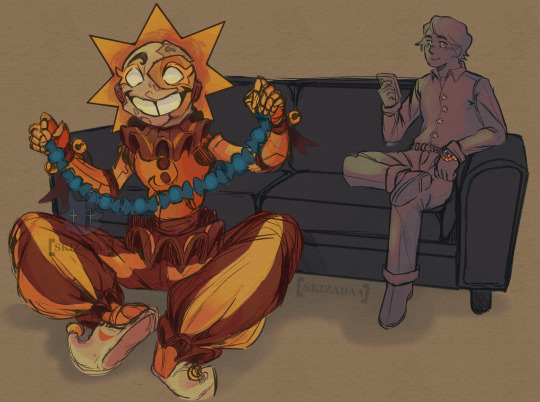
A break time sketch featuring @tuzesdays y/n from dayshift go figure
#skizabaa scribbles#sundrop fnaf#fnaf daycare attendant#fnaf sb#sun x reader#sun fnaf#dayshift go figure#its still somewhat messy since I didn't clean it up that much but I like it#slowly experimenting with how I draw sun and moon <3 its been super fun#tuzesday asked if I was gonna post this after streaming it on call and I went 'yeah sure' so here we are#skizabaa_scribbles
1K notes
·
View notes
Text
72 Needles In Millions of Haystacks // My First 24-Hour Orienteering Race
It’s somewhere around 3:00 in the morning. I’ve been up somewhere around 24 hours. And I’m… somewhere. I just don’t know where.
My partner Sean and I have just descended hundreds feet down a sheer rock face that’s dumped us into a pitch-black forest. Above us, a canopy of ancient pines blocks out the full moon. Below, the trunks of their fallen compatriots and an army of younger ones eager to take their place make our travel directionless and nearly impossible. And amid all this, we’re looking for a small, orange and white triangular flag with nothing more than a dot on the map, a compass, and the vague clue that it was located at a “reentrant.”
Suddenly, there at the bottom of that cliff, swallowed up by the forest, I felt very, very small. And very, very far away from anything. Forget finding the control, I think to myself. What if we can’t ever find our way out of this canyon?
Are we going to die down here?
__
A Little Compass Context
This was my first ever 24-hour rogaine orienteering race. I’d been introduced to orienteering a year and a half ago when my good running buddy Guillaume Calmettes invited me to a local event. He was using to sharpen his navigational skill in prep for his first run at the infamous Barkley Marathons. And he convinced me it was super fun and easy to pick up. He was correct.
In orienteering there are two basic formats. This first one I did was Classic, meaning you get handed a map of the area you’re in with little numbered dots on it. Then, you have to use your compass to find your way as you run from control to control in a pre-determined order as fast as possible. Beginner’s luck. I got second place. Guillaume got first.
The next event we went to the following month, I won.
Our compass skills were admittedly only okay. (Actually, Guillaume’s were fine. Mine, less so.) But having experience and fitness as a runner, helped us immensely. Still, we made plenty of mistakes. This year, I made some huge errors in races. It’s really humbling when it takes you 3:34 to finish a course, and the winner did it in 0:57. The beginner’s luck had run out.
Most orienteering events are relatively short, usually one or two hours long. But it’s incredibly intense. When you’re trying to find 15 different controls as fast as you can, you have your head buried in your map as you’re sprinting through parks, up and down hillsides and rooting through streams to find your controls.
Then Guillaume told me about rogaining. It’s the same thing, except it lasts for 24 hours. 🤯 I’ve run plenty of ultras that last longer than 24 hours, and I’ve done some orienteering races for a few hours, but I didn’t know you could combine the two. It sounded bonkers.
(For the record, the name rogaine comes from a portmanteau of the sport’s founding members’ names. It has zero to do with a fix for male pattern baldness.)
Guillaume and I talked wistfully about one day competing in the World Championship. Then, two months ago, I got a text. The North American Championship was taking place at the Nav-X Challenge in a month, in the Sierra National Forest. The top two teams would go to World. So we signed up.
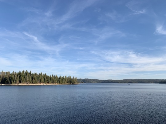
Lake Shaver, near the course
A few days later, Sean Ranney reached out to Guillaume to see if he could join the fun. If you don’t know who Sean is, he’s an incredibly accomplished runner who holds the Tahoe Rim Trail unsupported FKT. He’s also the creator of a Barkley-style race called Euchre Bar Massacre every October. He’s legit.
Then, with just two weeks to go before Nav-X, Guillaume ran into some problems with his visa and had to return to France the day of the race. Sean and I were incredibly bummed to lose G, but we decided to go on and do the race. “Do it for Guillaume!” we said. “Or to rub it in his face!” We hadn’t decided which.
___
What To Expect When You’re Expecting
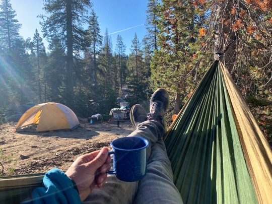
So, this is how I find myself waking up in a tent in the middle of the Sierra, waiting to be handed a map that would send me out into the forest on a very wild goose chase.
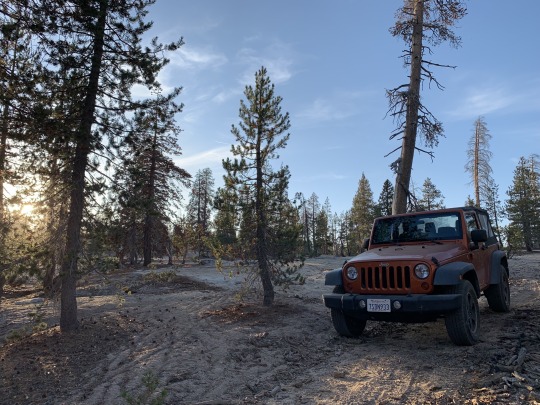
Camp/a Jeep commercial
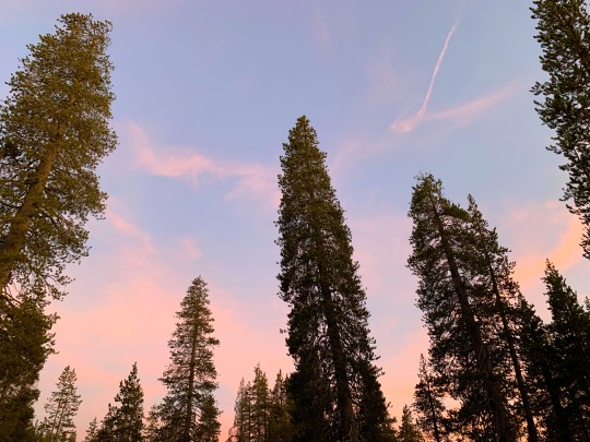
Sunset the night before
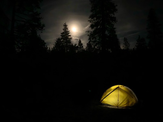
Full moon over camp
Waiting for Sean to show...
Nine o’clock rolls around. Time to receive our maps. Sean is nowhere to be seen. Nine-thirty. Ten. I look around as other teams scurry to plot their movements and prep their gear for the next 24 hours. Time is running out. Instead of feeling stressed, I’m a little relieved. Maybe I won’t have to do this after all…
Ten-thirty. Sean’s red truck rolls into the dusty campground. I guess we’re doing this.
In a supremely ironic twist of fate, Sean had gotten lost for hours while driving to the starting area. This does not bode well for our future prospects. We exchange quick pleasantries and immediately get down to the business of plotting our moves. The High Sierra sun already beats down on us as we squat over a stump, with our highlighters and sharpies clenched in our hands. It feels oppressive already.
The second type of orienteering is called Score-O. All rogaine races are Score-O. The premise is that there are flagged controls laid out across the course, each assigned a point value based on difficulty to travel to it or find. Rather than racing for the fastest time, everyone has the same amount of time to nab as many controls/points as they can. If you’re skilled enough to get every single control, you’ve “cleared.” It’s a game of strategy. Do you go after more of the easy controls that are closer to the start but are lower value? Or do you try to go out farther and burn time to get higher-value controls further afield?
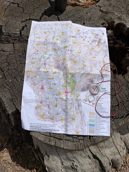
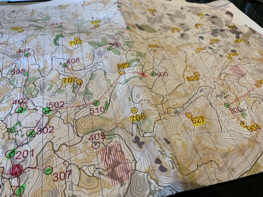
Looking at our map, we have 72 controls. The possibilities are pretty much endless as to how we can design our run. Hell, the map itself is huge. It’s over two feet tall. I’m just wondering how I’m going to carry this thing in front of me for 24 hours.
Being novices to this whole thing, Sean and I both frantically googled rogaine strategies in the week leading up to the race. Interestingly, it involves office supplies. So on drive way up the previous day, I had found myself in a Staples somewhere in the Valley buying various brightly color writing utensils.
First, we highlight all the high-value controls on the map in yellow. The locations of water drops we highlight in pink. It quickly becomes apparently that the northeast corner of the map has the highest concentration of 60, 70, 80, and 90-point controls, but they’re spread further apart, and the terrain seems to be more forested, meaning navigation and travel will be more difficult. Also, there’s more water. The southern portion of the course has the next highest concentration of points. It seems to be more exposed rock which will be faster nav and travel. No water to speak of though. The northwest sector is denser in the number of controls but they’re lower value.
The correct plan seems fairly obvious (I think). We decide we’ll make a big loop of the northwestern segment first while we’re fresh, it’s hot, and we still have sunlight. Then, we’ll loop back to the hash house (the start/finish area), resupply and head out on our second loop. This loop will take us to the south overnight, where it should theoretically be easiest to navigate and we won’t need much water. Then, we’ll head back to the hash house for another resupply and go out on our third loop to pick off as many easier, lower-point controls as we can before noon tomorrow.
(One thing to factor into strategy is the penalty for finishing late. In this case, we’d lose 10 points for every minute past 24 hours that we’re out of the course. So you also want to plan the end of your race to have points where you can call audibles towards the end.)

Marking up the map
With our basic game plan laid out, we quickly start penciling in lines of travel from control to control. Again, more strategy. This time we’re trying to make each move the shortest possible while also hitting every control and simultaneously avoiding any overly difficult moves due to a giant mountain between them, dense forest, whatever.
We check our watches. It’s just a few minutes before the noon start. We quickly draw over our lines in sharpie, shrugging to each other occasionally. “I guess this seems good, right?” “Yeah. It all feels easy right now at least.”
Slipshod plan formatted, we hurriedly stuff all our gear, clothes and food into our packs. Because, oh yeah, since you’re going to be out in the wilderness on your own pretty much the whole race, you need to carry everything with you too.
Ready to roll
Still cramming stuff in our vests, we amble up to the starting area. We are, as usual, the outliers. Like any sport, orienteering has its own mores, particularly when it comes to fashion. Pants to protect the legs while crashing through underbrush. Long-sleeved shirts to deal with fluctuating temperatures. Protective hats to block hours of sun exposure. Calf-high gaiters to keep shoes free from any debris. Big packs to carry a day’s worth of supplies. Hiking-style shoes to cover the harsh terrain. We have none of this.
No, Sean and I stand there in our bright, little running shorts. Thin, polyester shirts. Tiny packs. We have so much skin exposed, I’m sure the other races are wondering if we’ll die of exposure or blood loss first.
It’s also worth noting that Sean and I are on the young end of the age spectrum. By a lot. Looking around, the average age seems to be hovering around 55. Orienteering, for whatever reason, tends to attract a much older crowd. I suppose it’s because it’s a thinkers’ sport. As I’ve learned time and time again, a great navigator who can move slowly but efficiently can crush a fast runner who’s shitty at navigation. Skill and experience levels the playing field immensely.
It’s 11:59. Our big adventure begins soon. The race directors herd us into the starting corral and offer a few final tidbits of intel and advice. And then, it’s, “OK… go!”
“Here goes nothing…” I mutter to Sean.
___
Noob Troop Loop
Orienteering starts are funny. Because each team has chosen a different one of the millions of possible permutations of routes, everyone scatters off in totally different directions immediately.
Sean and I bound out of the campground and down the main dirt road to the first bend, where we stop and consult our maps. We line up our compasses and shoot a bearing to the east-southeast, where our first control, 307, will supposedly be. Flipping over the map, I read the description of 307 off the chart. It simply says, “Broad saddle.” We peel off and quickly find ourselves climbing up a steep hill, dodging underbrush as best as we can. Soon enough, we top out. The saddle. But where is the control? We run a few hundred feet to the right, nothing. So we backtrack and try the left. Soon, “There it is!” We see the orange and white dangling from a tree branch. We quickly insert our e-sticks (basically USB sticks attached to our hands) to record our presence and then immediately consult the map again.
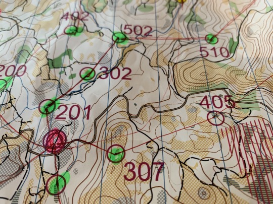
Moving from the hash house (pink) to 307 to 405
Control 405. To the east-northeast, maybe half a mile away. Rather than shoot straight there, we see that there’s a road between it and us. The road connects to another road that travels within about a tenth of a mile to it. And near there, there’s a junction with a trail. So, we can travel expeditiously via road, then shoot our bearing off the trail junction so we know exactly where we are and the exact angle we have to travel to reach 405, labeled “Marsh, S end.” Or at least that’s the idea.
We make our way to the road, turn on the second road, and fairly quickly find the junction. From there, we shoot the bearing and sprint off, back into the woods. Soon enough, we find a marsh and start scanning the area. Nothing. We move along the edge, trying to stay on the south side. But as the control continues to remain elusive, we begin just running around aimlessly hoping to bump into it. Ten minutes go by. “Where the hell is this thing?” “We’re definitely at the south end of the marsh… right?”
Finally, I pull my head out of the moment. “Stop. Let’s look at the map.” That’s when I notice that the marsh isn’t just one big strip; it has a bend into it, breaking the marsh into two distinct sections. “What if we’re in this part of the marsh, not over here?” Lightbulb. We’d overshot the bearing just enough that we’d landed ourselves in the smaller, adjacent part of the marsh. We turn 180 degrees and crashed through more underbrush until, there it was. The other part of the marsh. We sprint down its south face, and sure enough, the control comes into view. Ah, I’m starting to see how this is going to go…
We dip our e-sticks and I look down at my watch. 12:40. Two controls in 40 minutes. “Spot on pace!” I announce naively but also fully aware that it’s it’s naive. With 72 controls, to clear the course, we’ll need to find a control every 20 minutes for 24 hours straight. Two things: 1) That is an insane pace, and 2) it means we can make zero mistakes, like, ever.
So, time to get going. We consult the map again. Our next objective is 706, labeled “Reentrant.” We check our compasses and take off.
For the next hour or so, we’re cranking along nicely. Our control-every-20-minutes pace holds up. At 300 (“Broad terrace, N end”), I pull my head out of the map for a moment. It’s been two hours since we’ve started. “Holy shit. I feel like I’ve been out here with you all day,” I tell Sean.
There is no down-time in orienteering. No time to turn your brain off. No time even to eat or drink really. Your head’s always buried in your map, staring off the end of your compass, or scanning your surroundings, hoping to catch a glimmer of orange out of the corner of your eye. And as soon as you do and you’ve tag the control, your heads right back at it again. Oh, and you’re also running or hiking fully cross-country, hopping over logs, running down bare rock faces, hopping over talus fields, or breaking through underbrush, trying not to fall on your face.
Remember that thing you tried to do when you were little where you’d try to pat your head and rub your belly. It’s sort of like that except you’re also juggling a soccer ball, reciting pi to the 100th decimal, cooking an omelet, and doing your taxes.
___
Needle In A Haystack
The afternoon goes off relatively without much of a hitch. We trudge up hillsides, take shortcuts on logging roads that are nowhere to be seen on the map, skip across waterlogged marshes, cross long talus fields, and refill our bottles in cold, mountain-fed streams. Most importantly, we’re picking off controls here and there with only occasional difficulty. I actually can’t believe how well we’re moving. Honestly, I came into the race feeling only OK about my compass skills. But with the repetition of doing it over and over and over, hour after hour after hour, I’m starting feel cautiously confident.
Additionally, Sean and I have a very complementary partnership emerging. Ying and yang. He seems to be better with the compass and traveling over large distances to the general area of a control. Once there, I tend to be better at reading the immediate terrain and spotting the controls at a distance. (“LASIK!” I tell him. “The best money I’ve ever spent!”) And when one of us falters in his unspoken area of expertise, the other picks up the slack and the roles reverse. I’m really liking our chances.
Our entire northern loop
Eventually, we reach the very far northwestern corner of the map. 830, “Bare rock, W foot.” We sight ourselves off a massive wall of bare rock rising almost a thousand feet to our right. We’re almost surrounded by it in fact. I suddenly start to feel a quiet terror. It’s a cross between claustrophobia and helplessness. I realize just how far away we are from everyone and everything. Civilization. Safety. And any sense of origin. It’s like riding in an airplane and suddenly thinking about the fact that you’re 30,000 feet above the Earth in a metal tube. We round a giant grouping of boulders and thankfully spot the control. Mercifully, the feeling washes away in our excitement.
We make a few more moves. We shoot a bearing from 631 (“Stream”) to 821 (“Marsh, partially treed, SW part”). The move feels fairly complicated on the map. In practice, it’s even worse. But after 25 minutes or so, we find ourselves in the general area where we think we’re supposed to be. Except, we have no idea where we actually are. Or where the marsh is. Instead, we’re on a steep, loose hillside, chockful of deadfall and chaparral. This looks nothing like a marsh. This looks like the opposite of a marsh. Sean, sure he knows where we are, shoots off up the hillside. I follow him but only half-heartedly, feeling like he’s going the wrong way. My head starts to spin. The airplane feeling comes on again.
Five minutes later. “Stop! Let’s look at the map and see where we think we are,” I implore. “I think we’re here,” Sean points with the corner of his compass. I’m not sure how he arrived at that conclusion. But, scanning the dense canopy of trees enveloping us, I have no better counter. “I think we need to go back up here,” he points. I’m at a loss so I shrug and say sure.
We fumble around for another 15-20 minutes. Then I hear Sean shout, “Found the marsh!” “You glorious son of a bitch!” I exclaim and sprint towards the sound of his voice. Sure enough, he’s located a marsh perched on a shelf on the hillside. In my excitement, I try to hop over a huge trunk, but my shoe catches a piece of bark and I ragdoll. Flipping forward, I slam into the marsh, bent at a 90-degree angle the wrong way. “Shit! Shitshitshitshitshiiiit.” I follow up with, “I’m OK!” I look down at my knee, and it’s bright red. Blood oozes down, soaking my sock below. I pop up, more embarrassed than hurt. “You alright, man?” Sean asks. I look down at my leg, wet with blood. “Yeah, the flies are just going to have a little feast,” I grin.
After all this, we can’t even find the control. We flail a bit more until we realize there are in fact several marshes on this hillside. None seem to actually be on the map. We make our way from one to another, until we finally find our “treed marsh” and the control. Finally.
After spending the last four hours totally off-trail in the middle of the wilderness, our next line of travel bisects a trail and then turns into a logging road. We make it there, and it feels surprisingly wonderful to be swaddled in civilization again. And good thing too, because night is falling fast.
We have a half dozen more controls to get us back to the hash house, but most all are near roads or trails so we cruise through them without incident. The only snafu comes on the very final control, a quarter mile from the campground. 201 (“Stream junction”). At 20 points, it should be uber easy. But somehow we find ourselves going up and down a dry stream bed, back and forth, looking for a non-existent control. Something is clearly wrong, but we can’t work it out. We both get frustrated. I rise the idea of just cutting bait—it’s only 20 points after all—and heading home. But Sean’s stubbornness is quickly joined by my own, and we refuse to give up. I know this is a poor use of our time, but I know how angry I’ll be with myself tomorrow if we don’t get every control we try for. The moment of frustration forces us to pause and regroup. Sean looks at the map and, in his amazing wisdom that I still don’t understand, decides that we must be in the wrong stream. Looking at the map, I’m not sure that we could be in any other stream. But absent a better idea, I go with it. Five minutes later and back on the road, we spot our correct stream. We instantly feel foolish. Five minutes more of fighting vegetation along the stream bed and we find the control. A short jog later and we’re back at the hash house.
It feels good to be back amongst people and lights and manmade objects. The timing tent is playing some Zeppelin, and the RD offers me soup. I greedily accept. I see a full bottle of Mrs. Butterworth syrup sitting on a table and say, “Oh. Are you guys making pancakes later?” The RD stares at me and just says, “No.” “Uh… OK.”
It’s 9:30. We tell the few people lounging around where we’ve been, and they seem impressed. It feels good; we must be doing something right. We’re a third of our way through the course, which is great. But it also means clearing the course is out of the question. No mind.
I jog back to my Jeep, grab a fresh battery pack for my headlight and shove more gels, turkey sandwiches and formerly-frozen burritos into my pack. Ready to roll. We know night will be trying, but we just don’t know how much.
___
Descent Into Darkness
Time to begin our southern loop. Drier, opener, faster (supposedly). We pop out on the road and look for the second path junction to the left. According to the map, it should come very quickly. But it doesn’t. Or it does. We can’t tell. There are so many Jeep trails and turn-offs, it’s hard for us to know which is the correct one. We choose one that seems right. But the trail isn’t bearing in the direction it is on the map. Still we follow it. Dumb. We’re going uphill now. This seems very wrong. It’s supposed to be flat. Still we follow it. Finally we both agree it’s wrong. Duh. We head back down to the road. For some reason we think the trail must be farther away from camp so we head out. We take other side trails momentarily before deciding they’re wrong. We probably run at least a mile from camp. At some point, a pickup comes rumbling down the dirt road keeping up dust in our headlamps. “Oh hey guys! Is that Andy and Sean?” Through the floating dust and the stupor in my head, I can’t really make out who it is. After a few moments, I dawns on me that it’s one of the RDs. Sean explains to him what we are—or aren’t—doing. “These roads are all fucked up, man. Just get to a control and shoot straight lines from there,” he offers as advice. As the pickup chugs off, I say to Sean, “Well no shit. That’s what we’re trying to do.” But he’s right. The area is so heavily used we can’t trust the map or anything we see. So what do we do?
We fumble around for another 20 minutes or so before we finally identify a set of cliffs off to our right. On the map, we see a symbol for cliffs. We’ve finally located ourselves. PHEW. And we’re right by a control. We shoot a bearing and head off towards 202 (“Marsh, just N of N tip”). And we find it! We curse, we laugh, we howl. But we’ve found it. And we burned 70 minutes doing it. For 20 points. Just a quarter mile from the starting line. Woof.
With a new understanding of where we are, we shoot a bearing and head off into the wilderness once more.
Earlier that afternoon I had said, “How the hell are we supposed to do this in the dark?” Now that it was dark… yeah. “Flying blind” does not begin to accurately describe what we’re doing. We just take a bearing, point ourselves in a direction and pray that we end up there. And our “easier, rockier” loop is nowhere to be seen. It’s all dense forests with zero visibility. (Fun fact! Almost all 24-hour rogaines are held as close to full moons as possible!) The one advantage the night provides is that the controls have pieces of reflective tape on them. So, if you’re scanning your surroundings, your headlight might at least catch a glimmer coming off the tape. This proved appreciably helpful in spotting controls at a great distance, ones that we probably wouldn’t have caught in daylight.
But still, it’s just really fucking hard.
After we grab a few controls, we head towards a big section of cliffs. It looks cool on the map. It looks cooler in person. We claw our way up a sheer rock face onto what turns out to be a massive, smooth granite ridge, rising hundreds of feet above the surrounding valley. We find 902 (“Spur/bare rock, access from N or S”) rather easily. There’s nothing else up there besides the control attached to a lone tree clinging stubbornly to the rock. We register our e-sticks and then sit down for a minute.
“Wow. It’s really beautiful out here.” In the full moon, we can finally see the world around us. It’s a symphony of rock and wood and water lit by the pale glow of a giant rock floating in the sky reflecting sunlight from millions of miles away. For a minute, inside all the madness, the world is perfect.
“Dude. I’m going to eat my fucking burrito,” I exclaim. I throw my pack off and dig in, finding the now-nearly-warm bean and cheese burrito that had been sitting in the bottom for 12 hours now. I bite into it and immediately start moaning. “I can feel the endorphins firing in my brain,” I gush to Sean. He laughs politely. I’m in heaven.
A few minutes later, we say goodbye to the view, take our bearings and head down off the cliffs. Rather than change back to forest, the ground beneath our feet stays sandy and open. “Finally!” I shout. “The rocky loop we were promised.” Feeling in high spirits, we cruise downhill towards 506 (“Reetrant”). At only 50 points, this one should be no problem… Right?
Forty-five minutes later, Sean and I are just flabbergasted. I’ve run out of curse words. I’m empty. I’m fully defeated. We’ve run up and down this damn stream so long looking for a junction to shoot a bearing from that I don’t even know what my name is anymore. We’re flailing. Several times, I fully lose the thread. I look down at my map, and it’s gibberish. I forget which control we’re looking for. I start trying telling Sean he’s wrong, as I’m looking at a totally different part of the map. I don’t know what we’re doing anymore.
We sweep the forest back and forth, a few dozen feet from the stream and a few dozen feet apart from each other, hoping to catch the glint of reflective tape in our headlamps. But the battery on my light is dying and has automatically dimmed itself. Even if the control is out here, I probably won’t see it. If was more coherent I’d be upset. Instead I’m just apathetic.
Somehow, we decide to sweep in the opposite direction, way downstream, which feel very wrong to us, but at this point, it’s the only thing we haven’t done. Running—mostly out of desperation—we drop into a deep forest and begin thrashing around in the undergrowth when suddenly, “Holy shit! I’ve got it!” We find it. I have no idea how that control relates to what we were looking for, but I don’t care. Desperation gives way to a rush of relief.

Here’s what it looked like on Strava. Woof.
Later, as we’re following our next bearing, Sean and I both admit to each other that we thought about suggesting we just bail on the control. But then we both realized we couldn’t.
And here’s the true challenge of rogaine. Ninety percent of the time you can’t just skip a control that’s hard to find. Because if you don’t know where the control is, then you don’t know here you are either. And if you don’t know where you are, you don’t where we’re you’re going next. So, you’re forced to find the control, even if it feels impossible, because it’s your own way out alive.
The rest of the night continues on, eventfully and uneventfully. Ironically, we seem to have the most difficulty finding the lowest-point controls while the high-value controls are relatively easy to locate. We joke about it. It’s funny. I think.
Features like “clearing” and “reentrant” continue to be the bane of my existence. What constitutes one clearing over another clearing? What the actual fuck is a reentrant anyway?
We flail in the dark some more.
We drop down a rock face to a deep dark forest where I think we’re going to die. Somehow, by sheer miracle, I get the sense that the control is much farther north than we think it is, and we sweep the edge of the forest. Four minutes later, I catch the gleam of reflective tape in my headlamp.
Another time, Sean and I are a bajillion miles away from anywhere we think we know. We’ve been running across a series of gullies towards 907 (another fucking “reentrant”). We’ve run ourselves down deep into the folds of a hillside. We’re surrounded by rocks and more rocks. We have no idea where in the world we possibly are. And then all of a sudden Sean shouts, “I see it!” There it is, two hundred feet above us. Another miracle.
The night goes on, until dawn slowly yawns on the horizon. I realize I feel better than I’ve ever felt in ant 100-miler at this point. We’ve covering a lot of ground, and it’s more full-body, but I’m not gutting myself to do it. And the necessity of focus actually makes me feel sharp. Then I realize I’ve only eaten a few hundred calories all night. I check my water bottles. Oh yeah. I’ve only drank about 20 oz of water in the last 12 hours too.
No mind. The sun comes up and navigation becomes easier again. Weirdly, I miss the reflective tape. You can’t have it all.
The next control is 623. I read the description: “Pool at base of 8m water (no access from NW).” “Oooh! That sounds delightful,” I say. We find it. It is delightful. Just as the sun has risen, we find ourselves in the midst of a smooth, rocky gully with a gently roaring waterfall surrounded by glimmering pools of cool water. “I’m really glad we did this one,” I say out loud, instantly feeling like we’re an old, married couple.
Five minutes later, I’m blowing my ass out behind a bush.
Three controls away from finishing our second loop, we hit another snafu. We burn what feels like an hour wandering aimlessly through the forest. It’s 503 (another fucking “reentrant”). It should be easy. It’s not. I shout at Sean to stop and let’s think this thing out. We orient ourselves off a giant wall to the north of us and try to think our way out of this thing. Ten minutes later, I start shouting “Hallelujah!” as the world around us is finally matching up with the world on our maps. We split up and two minutes later I shout, “Holy shit I found it!” Seriously, what is a reentrant anyway??
An hour later, we’re back at the hash house. It’s around 9:00 in the morning. The first loop took us 9.5 hours. The second one took 11.5. Clearing the map is waaaay out of the question. But as we’re milling around the food tent, we still feel plenty good. Sean and I both make a beeline for the industrial-sized can of cocktail fruit and spoon the syrup and processed pineapple into our cups and guzzle it whole. It’s heavenly.
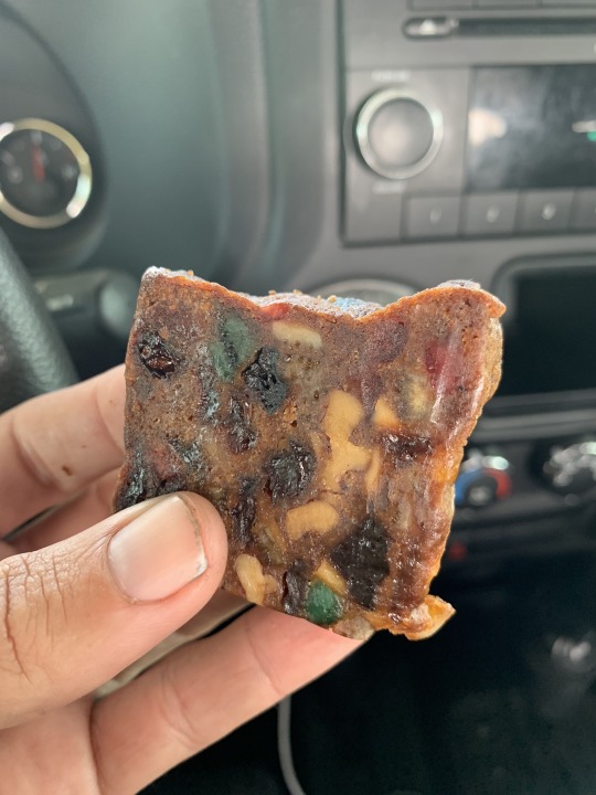
Also, fruitcake FTW.
___
Victory Lap?
We’re closing in on two hours left. It’s getting hot again. I know Sean wants to quit. He knows I want to quit. I know he knows that I want to quit. He knows that I know that he wants to quit. But instead, we make plans to head out on our final, truncated loop. We’ll pick off a few controls that are nearby with enough time to return before noon. (Good rogaine strategy! I feel proud.)
Sean looks a little rough. I didn’t eat many calories overnight, but he ran out. Nonetheless, all night, he’d pushed the pace on hills, leaving me in the dust. I’ve been perkier on the roads and had to pull him a bit. Basically, we’re both beat. We don’t want to admit it to the other person. It’s funny that we only met about 24 hours ago.
“We leave by 22,” we agree. Translation: 10:00am. We’ll have two hours to complete our mini-loop of four controls. It’ll only be 130 points total, but it’s more to prove to ourselves that we refuse to quit. At 10:00am precisely, we meet by the port-a-potties.
In my mind, this mini-loop is a victory lap. We find the first control with ease. The second with ease. The third with ease. The fourth one pretends to be difficult but soon we wrangle it in. With most of the course under our belts and 45 minutes left, we head back home.
At the hash house, we jam our e-sticks in the control labeled “FINISH” and give each other a series of handshakes, fist-bumps and hugs. We did it.
___
“That’s A Good Thing”
When we put our e-sticks into the download terminal—basically the thing that receives all those timestamps when we punched the different controls—the printer immediately spit out a long receipt-looking thing. “Wow. That’s long. That’s a good thing,” says the volunteer working the computer.
I look at my receipt. It says we have 2,900 points. I look over at the timekeeper’s screen, and the top number of points I see from other teams is 2,630. Whoa. We might have won.
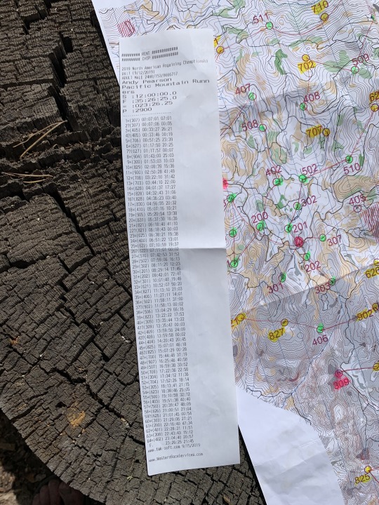
We did all that. Sheesh.
There’s still twenty minutes left—it’s 11:40am—so there’s a good chance another team could still come in and kick our asses.
Fifty minutes later we’re standing at the awards ceremony. I’m cracked out my mind. I’m dirty. Sticky. Tired. Blood-shot-eyes-y. But eventually the RD announces, “Male team, open… with 2,900 points… wow, that’s almost the whole map… Pacific Mountain Runners, Andy Pearson and Sean Ranney!”
Beginner’s luck again. We’re the North American Champions.
The best part about orienteering is how quaint it is. (And I don’t use that word pejoratively.) This award ceremony is only a few dozen people huddled around an awning trying to stay out of the sun. The awards come in dozens of flavors, across every possible permutation of age and gender divisions imaginable. And the awards themselves? A certificate declaring “2019 North American Rogaine Champion” with the name section blank—RD: “You can write your own name in” —and your choice from a variety of chocolates. As far as I can tell chocolate is the belt buckle of orienteering. The adventure has been so epic, and the reward so unassuming, it feels perfect.
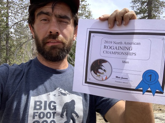
What winning feels like.
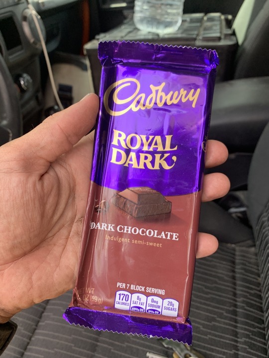
What winning tastes like.
___
The Venn Diagram
Reflecting back, I’m both proud of and humbled by what we did. The experience taught me more in 24 hours than I think I’ve ever learned. From geology to map-reading to problem-solving to ultrarunning to 500 other things, orienteering requires everything from you. But it’s a constant education too.
I love ultrarunning deeply. It speaks to a deep physical and spiritual part of human existence. But orienteering adds the mental aspect as well. You have to always be on.
We ended up moving more than 60 miles in 24 hours, with probably 90-95% of that being off-trail. (Full Strava details here.) During the race, I joked with Sean that the Venn diagram of people who would actually do this is so incredibly small. You have to possess the ability to run/hike at ultramarathon distances while also calling on a deep reservoir of navigational and outdoor experience. (Or in my case, just faking it.)
___
Not The End
If any of this sounds at least mildly interesting to you, I’d encourage you to look up orienteering clubs in your city. Almost all cities have one. In LA, ours is the LAOC. They have monthly events that are usually just an hour or two in length, and they’re a great way to try your hand at it. (Also, a fun family activity for kids!) Learning these kinds of map and compass skill is deeply rewarding and can add all kinds of new dimensions to your appreciation of the outdoors.
Basically, try it! And if you have questions or want some tips, let me know. I’m happy to help.
In the end, more than being proud of what we did, I’m proud of what we learned. And I can’t wait to hack our way through the Rogaine World Championship in Lake Tahoe next August. I just hope there won’t be any fucking reentrants.
2 notes
·
View notes
Last Seen Blogs

autistic-sidestep
bear bod wei chen agenda

kiingyaassin-blog
Kiing.yaassin

random-rottmnt-stuff
SUPPORT RISE!


hiroaki184
MUST BY MOST