#well y'know at least this is a substantial write up 🥲
Text
Re: Did Farragut Ever Experienced Tsunami? 🌊
In the original post, @aceofthyme commented:
I don't know much about the Pororoca, but I have studied tsunamis at uni, and I think it would still be possible for either of these to be a minor tsunami triggered by a minor earthquake, the first particularly if the quake was offshore. And, considering wave patterns of tsunamis, it's possible it wouldn't have been noticed out at sea, esp if it was minor. That being said, I think it's more likely you're correct about it being the Pororoca for the first one?
.
Alright, let's examine the points one by one.
First of all, how does an earthquake happen?
Earthquakes occur anywhere on the earth where there is sufficient stored elastic strain energy (think of the tip of a ruler fixed at the edge of a table. One end hanging off the edge, and then you press down on the hanging end, hold it a little while and then release it. It's vibrating rapidly up and down — that's the kind of energy we're talking about) to drive fracture propagation along a fault plane. The fracture propagation causes strain seismic wave (ie. the tremor, "quakes" one feels during an earthquake event), this happens at a fault line (ie. a line where two continental plates meet).
There are other causes of earthquake aside from tectonic ones, but the tectonic cause is the one most relevant to the topic we are discussing now.
There are three fault types, and all of them could cause earthquake.
•normal thrust fault (earthquakes from this fault tend to measure lower on the magnitude scale, compared to the ones caused by other types of faults)
•strike-slip fault (think of San Andreas Fault in California, US. Intermediate in strength, between normal and reverse thrust fault.)
•reverse thrust fault (this is the type of fault that gives really BIG earthquakes (8.0 and up), such type of earthquakes are also called megathrust earthquake (from how deep one tectonic plate goes under the other, which makes the other plate "bend" so much until it finally snaps back into its original position))
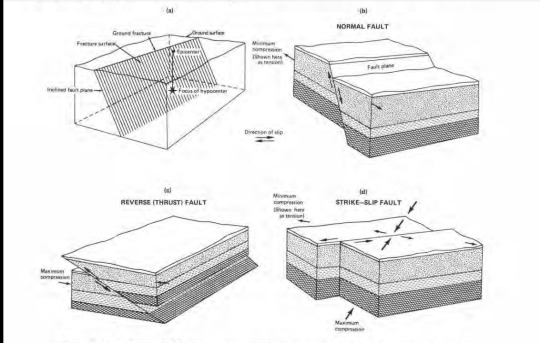
Types of Faults (source: Washington State Earthquake Hazards, Washington division of Geology and Earth Resources Information Circular 85, 1988)
.
Where do you find (tectonic) faults? Tectonic faults are found wherever there are two tectonic plates "meeting" each other — tectonic plate boundary. There are three types of of plate boundary
•divergent (the plates are moving away from each other, from the boundary line)
•convergent (the plates are moving towards each other, to the boundary line)
•transform (the plates' edges merely "touch", neither towards nor away from each other — the plates move horizontally against each other¹)
Reverse thrust faults are found on convergent plate boundary, normal faults on divergent boundary, and strike-slip faults on transform boundary.
(1: anyhow a little aside on transform plate boundary — remember San Andreas Fault, and the misconception that one day California is gonna fall off to the sea? Well, the reason that is a misconception is that San Andreas Fault is a strike slip fault — a transform plate boundary! So yeah, much as the plates are moving against each other, they are definitely not moving away from each other.)
.
So, that's an explanation about earthquake, what about tsunami? What caused a tsunami?
There are various causes to tsunami, from volcanic eruption to landslide by the sea to even meteorite (...yes, that), but again, for our topic the most relevant type would be the seismic cause — in another word, tsunamis triggered by earthquakes.
The most common type of fault causing earthquake (and then tsunami) is the reverse thrust fault. Earthquakes caused by normal fault activities could also trigger tsunami, but it is exceedingly rare. To determine whether an earthquake could trigger tsunami, one should not just see the type of the fault causing the earthquake, one should also measure how strong the earthquake is. As far as earthquakes have been able to be quantitatively measured (using first the Richter, later Moment Magnitude scale), tsunami-triggering earthquake usually measures at 7.5 Mw, sometimes (well, often actually) even stronger than that.
Keep that number in mind.
.
Bearing that in mind, what was the big surge of wave in Paraíba, Brazil that Farragut encountered likely to be? And what about the one he encountered some 130 miles away from Anguilla?
Let's go with the Brazil case first.
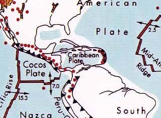
So, what could possibly trigger an earthquake off the Brazilian coast? For one thing, there's a tectonic plate boundary in the middle of the Atlantic ocean — Mid-Atlantic Ridge. What kind of tectonic plate boundary is Mid-Atlantic ridge? It's a divergent boundary (which would have normal fault as the active fault in turn — the thing that could potentially trigger earthquakes and tsunami), so while it could cause earthquake, it wouldn't exactly trigger tsunami.
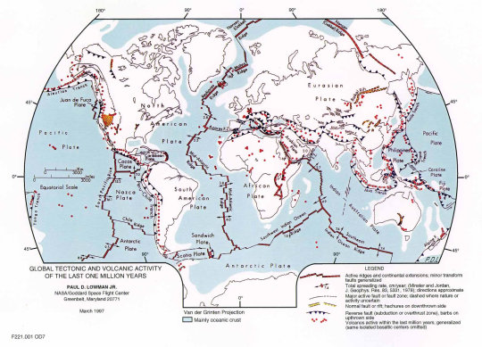
BTW this map also notes the types of tectonic plate boundaries, and as you can see from the arrows pointing away from the line, Mid-Atlantic ridge is a divergent boundary.
.
But wait — you said a normal fault could still trigger tsunami??
Yes, but as I said, it is exceedingly rare. The last time it happened (in Sumba, 1997), the normal fault off the southern coast of Sumba Island caused an earthquake measured at 8.0 Mw, which triggered a tsunami. So from this case, you could infer that while it takes earthquakes as strong as (or stronger than) 7.5 Mw to trigger tsunami (from a reverse thrust fault), it takes an earthquake (caused by a normal fault) with an even stronger moment magnitude (8.0 in this case).
How strong earthquakes from Mid-Atlantic ridge could be, then?
Here's a map of recorded earthquakes in every tectonic plate boundary on earth, measured in the 20th century (from 1900 to 2017 to be precise).
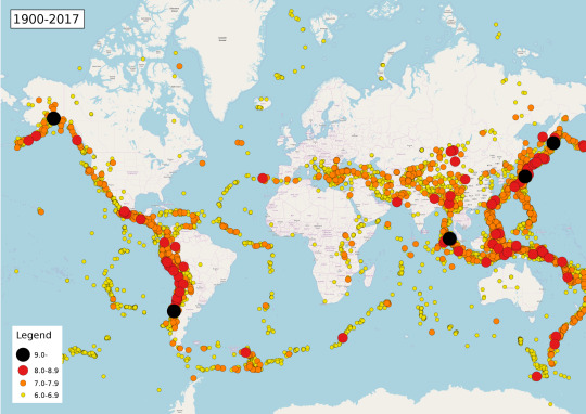
Let's zoom in closer to Brazil.
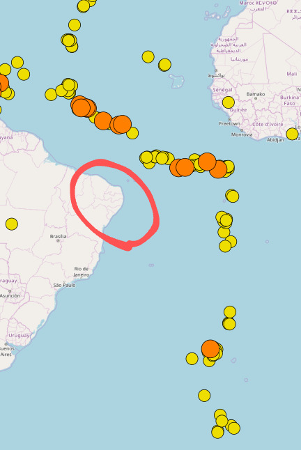
Boa Vista (in Paraíba) is within tbe region encircled in red.
As you can see on the map, the biggest magnitude of earthquakes measured (with epicenter from the Mid-Atlantic ridge) only measured up to 7.9 Mw at most. One should probably account how the grounds around the epicenter at the Mid-Atlantic ridge got displaced too, to see if the earthquake could trigger tsunami. That said, at the moment I am leaning more towards no — neither the magnitude was strong enough, nor the fault type would have caused tsunami in Brazilian coast off Paraíba.
So with all that said, I am more convinced what what Farragut encountered in Boa Vista around November 1842 is likelier to be pororoca instead of fully fledged tsunami.
Wait wait, what's pororoca again??
Pororoca is a tidal bore caused by the gravitational pull of the moon (and in some alignments, like in spring equinox, the sun), which is so strong it could reverse the flow on the Amazon river momentarily. At its peak strength it could travel inland and upstream as far as 800 km (500 mi).
(and yes, it has a characteristic loud roar, which makes pororoca extra remarkable).
.
And now, let's talk about the one in the Carribean — 130 miles off Anguilla.
Let's look again at the tectonic plate boundaries map, zooming in this time.
Hmmm, what is that?
If you remember the legend, the line with arrowheads indicates a reverse thrust fault.
Let's look at another map for a better look.
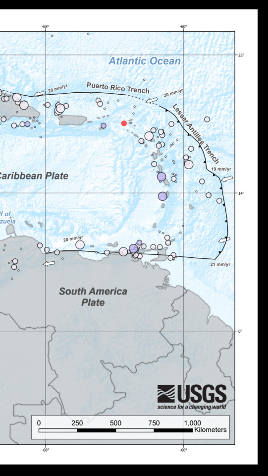
Anguilla is located to the right of the red dot (map source)
As you can see, the subduction trench — the reverse thrust fault (also with a similar legend) — is located at some 200 to 300 km to the east of Anguilla. Bear in mind the fault type — it's the fault that most likely to trigger a tsunami.
Now you see the recorded earthquake magnitude map, and you see that there are a few recorded earthquake with magnitudes measured at 7.0 Mw and stronger. One could definitely encounter an earthquake with an epicenter somewhere on the fault, with a magnitude of 7.5 Mw or stronger (which could trigger a tsunami).
And to top it all...
There was a recorded megathrust earthquake with the epicenter located on this fault line!
It happened in Guadeloupe, 8 February 1843, with a suggested magnitude of 8.0 Mw. In my view, it is likely that this earthquake would have triggered a tsunami as well.
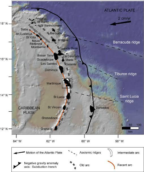
And to remind you on how things lay, here's a map showing where Guadeloupe is located (roughly SSE to Anguilla). The earth
It would have been great if the dates were written in the biography (because unfortunately it weren't written down 🤦🏾🤦🏾🤦🏾), but it was written down that Farragut only reached Chesapeake Bay in 11 February 1843 — the tsunami that he might have experienced could very well have been triggered by the earthquake happened on Guadeloupe (which would also explain that despite his ship sailing somewhat close to the fault line, the waves that he experienced was very strong, lasting a few minutes).
So that's how I came to my thought of the great waves that he experienced in the Carribean were likelier to be a tsunami (compared to the one he experienced in Brazil).
To broadly summarize...
The fault line in Brazil
1. is not the *right* fault type (normal fault), and even then,
2. the earthquake magnitude couldn't be great enough to trigger tsunami.
While the fault line in the east of the Carribean
1. is the *right* fault type (reverse thrust fault)
2. the earthquake magnitude could be great enough to trigger tsunami, and
3. there is a recorded megathrust earthquake around the time period (in which we focus our observation).
And that, I think, covers all the points in your response.
#writings#this was quite the writeup whoa#now this is either way superlate- or superearly-#farragut friday#lmao 🙈#geophysics#seismology#geology#maritime history#american history#earthquake#tsunami#well y'know at least this is a substantial write up 🥲#written as a response#not sure how else to tag it 🙈#geoscience#history#david farragut#david glasgow farragut
2 notes
·
View notes
Last Seen Blogs

white-persian-cat
White Persian Cat

cackled0g
In a Disputatious Mood

edgarvalentinf-blog
Joe Biden - Dems gefährden Trumps Leben

rosesnwater
RosesnWater

fit-her
Fit-Her