#westofsantafe
Photo

Diablo Canyon Recreation Area “Caja del Rio Canyon (known locally as Diablo Canyon), is a popular local rock climbing area on the northern section of Canada Ancha, near its confluence with the Rio Grande. This area can be accessed by Camino La Tierra and Old Buckman Road. Although the area is not marked, it has an undeveloped but very large parking area at its east end. The canyon walls include impressive trap rocks. The flat, sand bottom of the canyon is subject to spectacular flash floods during the summer monsoon season. The hike from Diablo Canyon to the Rio Grande is both scenic and easy (not for me). The wash is also popular with horse riders… …Diablo Canyon was a filming location for the 2007 film 3:10 to Yuma.” - Wikipedia The channel/arroyo that floods and has occasional water is called Cañada Ancha I was in the canyon a couple years ago. While we were in the canyon I heard the call of a Bald Eagle or possibly a Golden Eagle. The sound was bouncing off the walls of the canyon. The 7th photo shows an indentation in the canyon wall and a prominent petroglyph. #DiabloCanyonRecreationArea #DiabloCanyon #CajaDelRioCanyon #WestOfSantaFe #NorthernNewMexico #SpectacularCliff #Arroyo #CañadaAncha (at Diablo Canyon) https://www.instagram.com/p/CnDLZqUvQq9/?igshid=NGJjMDIxMWI=
#diablocanyonrecreationarea#diablocanyon#cajadelriocanyon#westofsantafe#northernnewmexico#spectacularcliff#arroyo#cañadaancha
0 notes
Photo
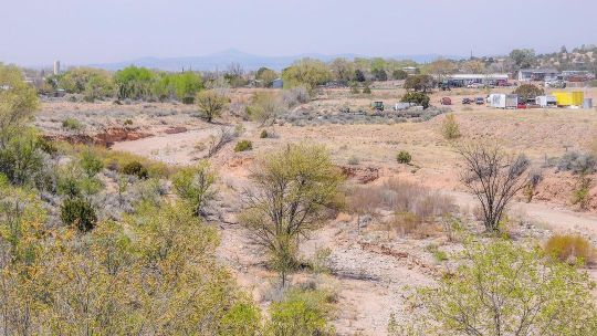
The view to the west yesterday from a bridge over the dry Santa Fe River. The smokey haze is from the Cerro Pelado fire in the Jemez Mountains which is about 35 miles to Northwest as the crow flies. The dry Santa Fe river is a symptom of the climate crisis which has led to a severe drought in the West. Normally this time of the year the snow melt would have resulted in a flowing a river in the Spring. Now the snow had melted except for a few patches here and there. We need moisture and lots if it! #Haze #SmokeySkies #WestOfSantaFe #ClimateChange #WeNeedMoisture #CerroPeladoFire #Wildfire (at Santa Fe, New Mexico) https://www.instagram.com/p/CdCZzTVrOwQ/?igshid=NGJjMDIxMWI=
0 notes
Photo

Jemez Mountain Views - I don’t have access to an unobstructed view of the Jemez within walking distance but I found a location to view the mountains over the roofs of buildings. The Jemez Mountains Are West Of Santa Fe and are an amazing place to visit. There are hot springs, a waterfall, the Soda Dam, Battleship Rock, Jemez Pueblo, Jemez Historic Site and the amazing Valles Caldera National Preserve. #JemezMountains #WestOfSantaFe #NewMexicoMountains #MountainViews #LandscapePhotography (at Santa Fe, New Mexico) https://www.instagram.com/p/CYmz0lbv2zE/?utm_medium=tumblr
0 notes
Photo

Diablo Canyon (6) Some of the flora growing in the Canyon. “Caja del Rio Canyon (known locally as Diablo Canyon), is a popular local rock climbing area on the northern section of Canada Ancha, near its confluence with the Rio Grande. This area can be accessed by Camino La Tierra and Old Buckman Road. Although the area is not marked, it has an undeveloped but very large parking area at its east end. The canyon walls include impressive trap rocks. The flat, sand bottom of the canyon is subject to spectacular flash floods during the summer monsoon season. The hike from Diablo Canyon to the Rio Grande is both scenic and easy. The wash is also popular with horse riders… …Diablo Canyon was a filming location for the 2007 film 3:10 to Yuma.” - Wikipedia #DiabloCanyon #CajaDelRioCanyon #WestOfSantaFe #NorthernNewMexico #SpectacularCliff #Wash https://www.instagram.com/p/CPHED7-r52E/?utm_medium=tumblr
0 notes
Photo

Diablo Canyon (5) “Caja del Rio Canyon (known locally as Diablo Canyon), is a popular local rock climbing area on the northern section of Canada Ancha, near its confluence with the Rio Grande. This area can be accessed by Camino La Tierra and Old Buckman Road. Although the area is not marked, it has an undeveloped but very large parking area at its east end. The canyon walls include impressive trap rocks. The flat, sand bottom of the canyon is subject to spectacular flash floods during the summer monsoon season. The hike from Diablo Canyon to the Rio Grande is both scenic and easy. The wash is also popular with horse riders… …Diablo Canyon was a filming location for the 2007 film 3:10 to Yuma.” - Wikipedia #DiabloCanyon #CajaDelRioCanyon #WestOfSantaFe #NorthernNewMexico #SpectacularCliff #Wash (at Diablo Canyon) https://www.instagram.com/p/CPHD1cVLMnL/?utm_medium=tumblr
0 notes
Photo

Diablo Canyon (4) “Caja del Rio Canyon (known locally as Diablo Canyon), is a popular local rock climbing area on the northern section of Canada Ancha, near its confluence with the Rio Grande. This area can be accessed by Camino La Tierra and Old Buckman Road. Although the area is not marked, it has an undeveloped but very large parking area at its east end. The canyon walls include impressive trap rocks. The flat, sand bottom of the canyon is subject to spectacular flash floods during the summer monsoon season. The hike from Diablo Canyon to the Rio Grande is both scenic and easy. The wash is also popular with horse riders… …Diablo Canyon was a filming location for the 2007 film 3:10 to Yuma.” - Wikipedia #DiabloCanyon #CajaDelRioCanyon #WestOfSantaFe #NorthernNewMexico #SpectacularCliff #Wash (at Diablo Canyon) https://www.instagram.com/p/CPHDK6hrYfP/?utm_medium=tumblr
0 notes
Photo

Diablo Canyon (3) Diablo Canyon’s unique rock face “Caja del Rio Canyon (known locally as Diablo Canyon), is a popular local rock climbing area on the northern section of Canada Ancha, near its confluence with the Rio Grande. This area can be accessed by Camino La Tierra and Old Buckman Road. Although the area is not marked, it has an undeveloped but very large parking area at its east end. The canyon walls include impressive trap rocks. The flat, sand bottom of the canyon is subject to spectacular flash floods during the summer monsoon season. The hike from Diablo Canyon to the Rio Grande is both scenic and easy. The wash is also popular with horse riders… …Diablo Canyon was a filming location for the 2007 film 3:10 to Yuma.” - Wikipedia #DiabloCanyon #CajaDelRioCanyon #WestOfSantaFe #NorthernNewMexico #SpectacularCliff #Wash (at Diablo Canyon) https://www.instagram.com/p/CPHDADLLT95/?utm_medium=tumblr
0 notes
Photo

Diablo Canyon (2) “Diablo Canyon Caja del Rio Canyon (known locally as Diablo Canyon), is a popular local rock climbing area on the northern section of Canada Ancha, near its confluence with the Rio Grande. This area can be accessed by Camino La Tierra and Old Buckman Road. Although the area is not marked, it has an undeveloped but very large parking area at its east end. The canyon walls include impressive trap rocks. The flat, sand bottom of the canyon is subject to spectacular flash floods during the summer monsoon season. The hike from Diablo Canyon to the Rio Grande is both scenic and easy. The wash is also popular with horse riders… …Diablo Canyon was a filming location for the 2007 film 3:10 to Yuma.” - Wikipedia #DiabloCanyon #CajaDelRioCanyon #WestOfSantaFe #NorthernNewMexico #SpectacularCliff #Wash (at Diablo Canyon) https://www.instagram.com/p/CPHCZ5rrz6L/?utm_medium=tumblr
0 notes
Photo

Went for a hike today at Diablo Canyon about 17 miles west of Santa Fe on a dirt road in bad need of grating (nothing but washboard-like driving max 15-20 miles an hour). Diablo Canyon is adjacent to the Camino Real de Tierra Adentro (Royal Road of the Interior Land). Which was an historic 2,560-kilometre-long (1,590 mi) trade route between Mexico City and Ohkay Owingeh (formerly San Juan Pueblo), New Mexico, USA, from 1598 to 1882. It was the northernmost of the four major "royal roads" that linked Mexico City to its major tributaries during and after the Spanish colonial era. #DiabloCanyon #Exploring #NorthernNewMexico #CaminoReal #WestOfSantaFe (at Diablo Canyon) https://www.instagram.com/p/CPHBcEgLqQk/?utm_medium=tumblr
0 notes
Last Seen Blogs

qingyumokinnie
Zeilder!!

its-the-bookworm
Just a Silly Little Author

letsrunfromhere-blog
Relentless Chaos

cyberdudedotcom
a volte non sembra vero..............

kaede2705
Untitled