theunusualworldofmountainwalking
The Unusual World of Mountain Walking
52 posts
Don't wanna be here? Send us removal request.
Last Seen Blogs

spaus-week
SpAus Week 2024

os-a
OSAMA
himchanshipbones
Just call me hip bones

ourbestside
OurBestSide

oscarvifer
oscarVíFER
Text


Hot hike / run up the VK
0 notes
Text


Started a Plain Joux, walked through the lift system towards Chalets D'Ayeres des Rocs, Ascended Broken ground towards Pointe du Derechoir fore the the fixed cable ways and ladders, topped out on to Passage du Derechoir Ridge . Traversed to Col de Portette, Ascended to Refuge de Pate, took steep descent path to Chalets de Platte, les Egrattz, before entering the montane environment at Charbonniere - descended ttoo low tot Praz Coutant before road ascent to Plain Joux
0 notes
Text


A quick scramble over on Sentries Ridge on Mynydd Mawr
0 notes
Text


A nice day linking up some scramble routes in the hills of North Wales.
Wrinkled Tower - Across North Ridge and Down Nor Nor Gully slightly - Notch arete - Tryfan summit - Bwlch Tryfan (the col between Tryfan and Bristly Ridge) - traverse to reach just above Alphabet slabs and then up East Gully Arete - Down Bristly Ridge
0 notes
Text


Scramble up Dolmen Ridge #northwales #glyderfach
0 notes
Text


Scramble up Little and North Gullies #northwales #tryfan
0 notes
Text


Scramble up Bristly Ridge #northwales #gylderfach
0 notes
Text


Scramble up Nor Nor Buttress, summit of Tryfan, down South ridge, up Pinnacle Scramble, summit of Tryfan and down North ridge
0 notes
Text


Scramble up Clogwyn y Person Arete, down Crib Goch, over to Lliweed, up Slanting Buttress ridge, walk out on the Miners track
0 notes
Text


Our annual Failey Family hike, this time up Snowdon via the Watkins Path
0 notes
Photo


I walked up to the jonction! It is one of the classics of the Mont Blanc massif and the Chamonix valley. It joins the bossons and taconnaz glaciers and offers staggering views of the aiguille du midi, some du gouter and the aiguille rouges. I started on the bus where I got dropped off by the ski jump. From here i walked up to Le Mont and followed the obvious path all the way to the top! It's sign posted for 6 hours up but I walked it in 2! There was a chap at the top who had run it in 1:25 mins! The path goes past the chalet des pyramides offering beautiful views of the Chamonix valley and an opportunity to buy a drink or snack. There are plenty of yellow dots along the entire walk which always clearly show the route to follow. It's the same route to walk down.
0 notes
Photo


We started at the car park just above Les Allamands. We took the main foot path loop from there up what was like a big dirt track to Refuge Bostan Tornay. We then continued up to the Col de Bosta, Tete de Bosta and round to the Refuge de la Golese and back round to the car via the main route. We saw edelweiss for the first time at the top of the tete de Bosta and also found some new flowers like St Johns Wort and alpine calamint.
0 notes
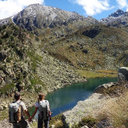
Photo


Today Fred and I hiked up Mont Joly.
It is a fine walk to the best view onto the western flank of the Mont Blanc massif.
We started at the Les Hoches (circa 1050m). The well-marked trail climbs steadily (but fairly steeply) through beautiful meadows and natural mixed forest, below cliffs and high ridges.
We enjoyed a miraculous selection of alpine flowers, including perfect gentians and cluster-headed little orchids.
On our arrival at the ridge we marveled in the all-round view from the pyramidal Mont Joly. There was a very informative orientation table which we spent a while looking at which helped us to identify all of the beautiful mountains in the distance. The summit offers one of the best possible views of Megève and Contamines. I loved looking at the Royal Traverse and imagining Fred and I will do this alpine route next winter or summer.
After Mont Joly summit we then went onto Tete de la Combaz and then down to Le Baptieu.
The route in total took us around 5 / 6 hours.
1 note
·
View note
Photo


Today i went on a morning walk with Yvonne to Aiguillette des Houches.
We drove up and said our prayers in Le Coupeau and parked at Le Bettey. We took a path from Le Bettey up towards Le Flatiere and then up to Pierre Blanche. It was all well sign posted so no real need for navigation with the map. We were just able to enjoy the stroll and the views. We picked some bilberries by the path and enjoyed the airy ridge and views of Mont Blanc Massif and Aravis with Pointe Percee in the backdrop. We had some rock cakes I made at the top and then made our way down via the Chalets de Chailloux. The chalet was closed but we had a little wander around to see if we could find any winter rooms and there were none. The whole area is classic high grazing terrain and the path was filled with sheep poo! From Chalets de Chailloux we took a quick descent back to the car and I got home in time to get my work done for the day!
0 notes
Photo


The Pointe Percée is the highest mountain in the Aravis range of the French Prealps in Haute-Savoie. It rises to 2753 meters and has 1643 m of prominence, and is thus is classified as an ultra prominent peak.
Fred and I did this route with one of our close friends called Simon who I did my SML training with a couple of years back. Simon was a strong trail runner having competed in UTMB in the past however he has just recovered from a hip operation which left him unable to do any physical exercise for well over a year. This route reminded Simon of how much he enjoys being out in the mountains and that he has retained more strength than he expected.
We started the route by driving from St Gervais (where Simon lives) up and through Le Grand Bornand, towards the Bouchet valley. At a place called Les Plans we found a small road that climbs towards Col des Annes, where the road ends. We parked in the small parking of the farmhouse.
We took a path signposted to the refuge and it took us approximately 1.5 hours to arrive there. From here we could see the majestic pointe percee and decided to take the climbing route up. The climbing route is well marked all the way up and although it looked gnarly we didn't rope up as it only seemed like a grade 2 scramble with a small amount of exposure and solid hand and foot holds.
When we got to the top the route had beautiful panoramic views and we spent an hour on the summit looking at the mountains and eating our lunch.
We came down the normal route which was more like hike down a scree slope and we were glad we did the climbing route up and not the normal route as the climbing scramble was much more interesting.
0 notes
Photo


We started Mons. We parked the car 1.2k away from the main parking area to avoid parking fees at the tourist information shop in town. We walked up into the start of the Gorges d'heric and crossed over the bridge to join a path to sentier des gardes. This part of the journey had most of the steep incline, walking up a main pebbled path in the trees. We then took col de Bertouyre to Table d'orientation. The view from here were panoramic views all the way to Narbonne and the mer mediterranee. We then went to take a look at the refuge font Salesse. It had enough to sleep about 8 people upstairs and an area downstairs for cooking, eating at the table and a fire. We were visiting at a quiet time in beginning of July therefore there weren't too many other people about however I expect some people stay in the refuge in the middle of summer (even though it is a bit dirty and mistreated). We then took a path over to Douch which is a little town where we found a water supply and a main road runs up and through it.
We took in the summit of Le mont Caroux at 1034. The story has it that there is a legend of Cebenna who is a beautiful girl that Zeus became jealous of and he decided she must die of love. She became infatuated with a lover and because she was unable to win his heart she decided to go to the mountains and live alone there and cry herself to misery. Nature, to immortalize her turned her forever into stone.
After that we went down to Heric which houses a couple of families there who own a cafe for walkers by. In the 19th century about 50 people used to live in that hamlet amongst various crops and chestnut trees.
We then took a route through the Ruisseau d'Heric and jumped into the gorges to cool off from our walk before getting back to the car and head back to Bize Minervois.
0 notes
Photo


We started from home in Argentiere and walked to the petit balcon nord until we reached Lavancher. From Lavancher we took a track up to a buvette called chalet chapeau. There were beautiful views from the top looking over le mer de glacé.
1 note
·
View note