
Don't wanna be here? Send us removal request.
Statistics
We looked inside some of the posts by travellingpair and here's what we found interesting.
Average Info
Notes Per Post
55
Likes Per Post
35
Reblog Per Post
9
Reply Per Post
11
Time Between Posts
5 months
Number of Posts By Type
Text
16
Photo
1
Last Seen Tumblr Blogs


Fun Fact
28.6 is the average number of monthly visits per US mobile user.
Text
Wednesday July 10th
I had intended to blog last night but was unable to get on the internet so apologies if you were looking for one!
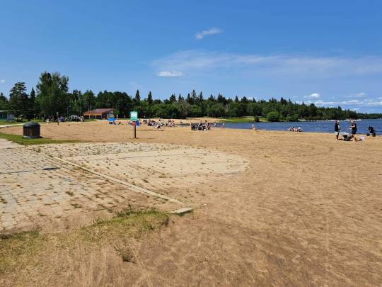
Monday night we had a thunderstorm, thankfully didn't cause us any problem. We have been having very hot days 30+c and nights so we have resorted to using the aircon to get it cool enough to be able to sleep!. On Tuesday we were on the road again, HW16 West to Saskatoon, intending to have a breakfast stop along the way so we had to wait until we got to a mall in Saskatoon some 114 miles and 2 hours later! The scenery over the last day or two had been varied, with vast fields of yellow headed Canola (an edible version of Rapeseed) on one side of the road and poor looking scrub on the other or fields of what I think was soybean. We've also seen lots of warning sighs for deer and unusually moose, in what appeared to be flat, mostly treeless land. We did see a stag enjoying a snack of Canola by the roadside but that was all. Passing Big Quill Lake Mary spotted some pelicans! there also seemed to be a lot of excavation back beyond the fields which we understand were potash mines, which could explain some of the poorer land and also the small lakes which were an odd colour. There is a larger lake a little further south from our route where you can simply lye back and float due to the mineral content. We checked how to get to a Western Development Museum called Boomtown which we visited 10 years ago, followed satnav and got to their headquarters, not the museum, but found out where it was, close by and drove there. This is a museum set up showing the gradual development from the early settlers to when the railroad was built and more people were able to get to the area. There is a main street set up indoors with all the stores and offices, school, church etc you would expect to find in the 1930s town. Very well worth a visit!! I'll try and pop some photos in later. We had some lunch, picked up some groceries then headed South on HW60 to Pike Lake Provincial Park for the night. A very very busy place with a lot of day visitors as well as campers. Nice sites and a good beach.
Today our plan was to get to Battleford, Northwest of Pike Lake to see the third Western Development Museum, Part of our journey was passing through First Nation Reserves, Red Pheasant Cree, and Mosquito Band . It was very obvious the change in the scenery from the big fields of canola etc to very rough land only suitable for rough grass and trees, which is typical of what the First Nations peoples we forced into by the Government. Got to Battleford and couldn't find the Museum, and kept on going to Lloydminster which straddles the Saskatchewan/Alberta border, found a campground just west and set up for the night. We have now covered 2355 miles. No photos yet!!
Thursday 11th July Day 12 of our journey
Up and away at 8.so this morning to backtrack to Lloydminster for fuel then headed North up along the border with Saskatschewan before turning West again for a breakfast stop at Marwayne, a lovely little town of nice clean streets with paved brick crosswalks, flowers in hanging baskets, and a nice friendly atmosphere. Our stop was at the community centre where there was also camp sites with electric hookup. We picked up some milk and got back on the road. Our target today was Garner Lake Provincial Park so it was a bit of zigzagging North and West to get there only to find that you have to book Alberta Parks online. Tried that and failed so on the road again with a lunch stop at a rest area before finding a campground at Waskatenau which was at the Ball Park. a pretty good place for a night especially at only $20 with electric hook up! The honour system again, put the money in a supplied envelope with a registration form and that was it. Today's scenery was mostly rolling hills again with some crops but also cattle. Lovely to drive along the lesser roads with no hassle from traffic! Another very hot day, even at 5.30 it was 37c!
Some photos from earlier in the journey:
Falcon Lake Manitoba
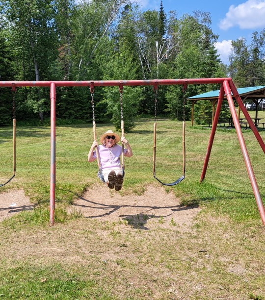
Mary (aka The Navigator), "never to old for a swing"
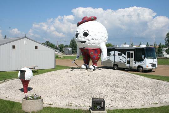
Anyone for Golf?
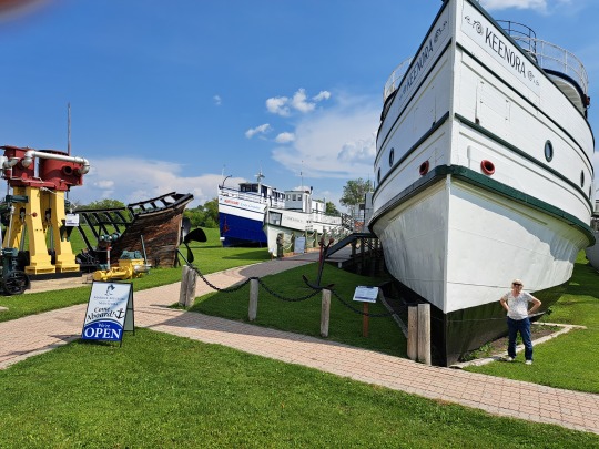
Some of the old Lake Winnipeg Steamers
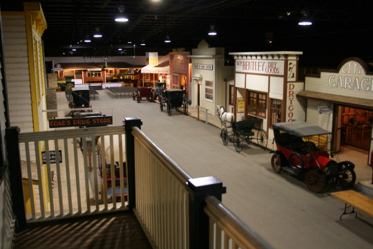
Part of the street in Boomtown, Western Development Museum.
16th July Day 17 of our travels.
Unfortunately we have had internet problems and Tumblr problems so apologies for lack of blogs. I well keep this catch up one brief if I can!
So I left you Thursday 11th July! Friday 12th we travelled West and South around Edmonton, via Barrhead, Mayerthorpe, Edson, trying to find a campground for the night. Not easy with no staff at Provincial Parks and other places down long washboard dirt roads to fin nothing! Eventually found a site at Hinton, which seemed to be on First Nation land. No power hookup but we were fine with that after driving 309 miles.
Saturday 13th We slept in this morning due to the long drive and the heat. Next stop Jasper, Alberta. We hadn't travelled this route before so had a very different view of the Rockies! Awesome, beautiful, massive, not enough to fully describe the views. had a wander around Jasper, got some good advice and maps at the visitor centre, but were told all the campgrounds were full! We could try the overflow sites outside town. which are first come first served and got a lovely site in the trees. No services and no phone signal. We stayed there 2 nights.
Sunday 14th July. Up and out early as we wanted to drive up to Maligne Lake and try to beat the crowds! Along the way up the 40 odd kms we stopped at Medicine Lake for photos and the a little further on to see and photograph the Bald Headed Eagles nest with 2 young eagles perched on it. On up to Maligne Lake, already quite busy. Had a walk on a 3/4 km. trail along the side of the lake to a viewpoint and then back to the carpark, now very busy and back down to a picnic site by the Maligne river for breakfast. On the way down we had a deer encounter, a stag and small herd. Back to Jasper and the campsite after stopping off to do laundry.
Monday 15th July. Jasper to Clearwater, British Columbia. A stop at the Mount Robson Visitor Centre. We were noy going down the West side of the Rockies. A short stop at Valemount for groceries (lovely little town). Along the road we saw a bear cub bouncing across the road, I'm sure mama bear wasn't too far away in the bushes! Beautiful views of the snow capped mountains as we descended into the valley, where it was mostly trees! Got to Clearwater and our Campground for the night. Power and water hook up!
Tuesday 16th July. Clearwater to Kumsheen. Back on Hw 5 South to Little Fort where we branched off on Hw 24. to begin with a twisty road through farmland then for over 12 Kms we were climbing all the way. Stopped at Goose Lake for breakfast, then on to join Hw 97 South to Cache Creek where we took HW1 South. More long climbs up along side the Frazer River with lots of bends with huge drop offs on the right. there were 2 railway lines down in the valley, one either side of the river. Saw the Rocky Mountaineer on one track and freight trains on the other. Lunch stop overlooking the gorge and river. Outside temp 48c. On down looking for a campground with power hook up so that we could run the aircon, and found Kumsheen River Rafting and campground. Very open site at the side of the highway with the rail lines below us, but we have power !! We travelled a mere 192 miles today, with a total since leaving home of 3417 miles. That's all for now folks, sorry it is just so difficult to get the photos on here! If you are still with us please comment or email me [email protected].
WEDNESDAY 17th JULY DAY 18
We were up very early this morning and left the campsite at 6.00am to get through Vancouver to the ferry port and hopefully get across to Vancouver Island at Nanaimo. Twisty road with huge drop offs on the passenger side (Mary wasn't happy).Thankfully very little traffic until we got closer to Vancouver, and the commuter zone. A lot of stop go traffic which was tiring and stressful. Got to the port and paid our ticket as a reserve since we hadn't booked ahead. Once we got into the the lane we had breakfast. It was 10.30am and we had been driving for 4 hours and 176 miles. Didn't get the ferry and had to wait until getting on to the 1.40pm one. Once off the ferry we headed directly south to Victoria. Very busy road with many traffic lights and speed limit changes, but we made it to Fort Victoria RV park and booked in for 3 nights.
Thursday after a great night's sleep we got the bus into Victoria, went to the visitor centre and got some better maps for our stay on the island. then we strolled around the port watching the seaplanes coming and going and the little water taxis buzzing around. We walked all the way round to Fisherman"s wharf, and decided to take a water taxi back to the inner port. We took a walk around the parks and markets in downtown, had lunch from a food truck in a park beside the Royal BC Museum. After a further stroll around we got the bus back to the RV Park, for a relaxing late afternoon and evening.
Friday was the planned visit to Butchart Gardens where we had breakfast in the RV before spending around 2.50 hours walking around all the different gardens. Absolutely beautiful but very expensive! Had lunch and made our way back to the RV park for our final night in Victoria before moving North to explore more of the island.
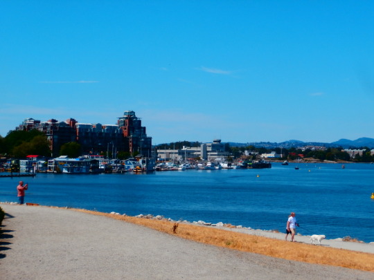
Victoria.
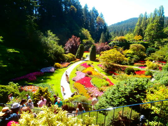
Butchart Gardens
Tuesday 23rd July.
Quite a lot has happened since we left Butchart Gardens but I will try to keep it brief! On Saturday morning we drove back up to Nanaimo the took the the road to Port Alberni and on down to Ucluelet and Tofino. Hilly, twisty and very narrow in places but we made it it down and got a place for the night in the overflow at Ucluelet Campground. Decided to leave going to Long Beach for a walk and swim until tomorrow and instead went across the road to Howler's for their excellent food and had fresh caught Halibut and chips! Delicious!!
When I woke on Sunday morning I could hear a fog horn, and looked into greyness. We got on the road to Long Beach but by the time we got there it was thick fog and raining! Should have had the swim last evening after all! So it was back up the 90 odd miles to the highway to turn North for Courteney and Comox, where we eventually found our way down to Fisherman's Wharf, where we hoped to get some fresh fish. Had a chat with one of the fishermen and got 2 Rockfish, filleted as we watched for $10! Enough for 4 meals for us so 3 into the freezer and one kept for dinner. Had a walk around the marina then we decided not to go further up the island but to go back south to Nanaimo and see if we could get on the Ferry back to the mainland on Monday. We didn't get the 6.30 am sailing so whilst we waited she baked 2 more wheaten loaves. The 9.05 was also full but we finally got the 11.25. Then it was on to the mad highway through Vancouver in heavy traffic (is it ever anything else?) and many sudden slowdowns to a crawl before getting to Bridal Falls at 3.30 for a lunch stop, then on to Hope where we got a spot in a First Nations campsite right on the Frazer river. We had stayed there before , but they had made a lot of upgrades to provide power, water and waste water hook up.
Today, Tuesday 23rd, we decided that due to the many wildfires burning and road closures on the route we had intended to take, we would stay South through the O'Kanagan wine region and into the Kootenays. I couldn't believe the number of wineries and fields of vines, fruit trees and produce. The roads varied from driving through beautiful lush (irrigated) valleys to barren hills, long slow pulls up steep, twisty passes and then roller coaster runs down the other side with tight bends with steep drops offs. We had a lunch stop at what looked like an oasis in the barren mountains called Osoyoos. A large lake which seemed to be one big resort! We moved on to go over more mountain passes and steep dop offs to Castlegar where we are spending the night at Castlegar Golf Club and RV Park. A lot of miles covered today 297, with the journey so far 4500 miles! Times for bed now!
Saturday 27th July. Update from 24th to date.
Most of our stops at night have had no internet and no or very little phone signal, so blogging was not possible. So I'll bring everything up to date now. On Wednesday 24th we set off along a long slow corkscrew road up over a pass and down the other side. Slow progress with the steep climb up, the many of the bends a bit scary with huge drops to the side and into Salmo, along the valley and a breakfast halt outside the town. Then it was off up over the Kootenay Pass with similar climbs etc as the last one, and into a lush valley with farmland and orchards into Creston. Passing through the town we had a major Oh S*** moment when 3 deer ran out just in front of us. Thankfully we were still in the 50kph zone some I was able to brake to a stop without hitting them! Later we passed along the side of Moyie Lake, a lovely are which seemed to be cottage country and our first timezone change on the return journey. Stopped at Cranbrook to stretch our legs, the back on the road searching for a campground that had space and power, Fernie and Sparwood had no space so we had to head up the Crowsnest Pass into Alberta to a campground there arriving at 8.00pm very tired and glad to stop for the night, after 256 miles of tough driving over the passes. I then had a d'oh moment when I went to have a look at the dash cam footage to discover I had forgotten to put the sd card back in!
Thursday we decided to head north to Nanton to take a look at the "Bomber Command" Museum, a very interesting place dedicated to the Bombers of WW2 and the Canadians who crewed them, had a long chat with one of the volunteers who provided a lot of great detail of some of the men who flew and died on missions in Lancasters and Mosquitos. They even had a restored Lancaster in the display along with many other aircraft, and replicas of the bombs including the Barnes Wallace "bouncing bomb used to breach the dams above the Ruhr. Well worth the visit and the entry fee! Booked into the Lions campground for the night, had a walk around town had ice cream before back to the RV where I lay down for a rest and promptly fell asleep! Dinner was a little late!
Friday 26th we headed south again to Fort MacLeod. Had a walk around the town admiring the original frontages on the main street before going into the Fort itself. Another interesting place with a lot of history, displays of the times including a lot about the First Nation People, where yet another treaty was signed between the British and the First Nations in the area. There was even a Musical Ride by some young riders dressed in the traditional North West Mounted Police uniform, the forerunner of the RCMP. A great show and again worth the visit. As an aside went to an ATM to get some cash and it ate my debit card! Back on the road we stopped at Walmart in Taber to get some fresh produce which they didn't have, not our first experience of a Walmart with no produce, and then on to Lethbridge to stop at a TD re my card, and Walmart for the night. It was very hot and so we needed to get the air going, which meant using the generator, which refused to start. No choice but to go on to Bow Island Centennial Park, which was a lovely big park area with power, water and showers, and parked for the night. 229 miles today.
Saturday 27th July, After a chilly night (9c) left the park and after a minor navigation error which had us waiting at a level crossing for a long train to go past, the barriers lifted and then dropped again for a second long train, and got onto Hw3 heading East to Medicine Hat, where GPS led us astray trying to find Walmart or another place to get the berries and milk that we hadn't been able to get yesterday. Eventually found one, got on the road again this time heading East into Saskatchewan to Gull Lake where we had decided to turn south to see what Southern Saskatchewan had to offer off the main highway. We had a lunch stop there and a chance for me to clean out the fan unit on the cooler as it was making strange noises! On the road again, the landscape was now changing from fields of crops north to the cypress hills and valleys, and more cattle ranching and terrible roads! Now seeing a lot of the oil pump heads in the fields of hay and the occasional crop. Turned East again and had a really bad journey on a terrible road, although we did encounter 7 deer by the roadside, that was the best bit of a long boring bumpy drive to "Cadillac" where we saw a camping sign only to discover there was some kind of rodeo going on. Eventually found another way into the camping area and set up for the rest of the afternoon and night. Had a look around what was going on and spent a little time watching teams separating a specified young bullock from a large group and then try to rope it successfully for the judges. Interesting, even if we didn't understand much! So we have now covered a total of 5193 miles! Sorry, still having tech issues getting photos off my phone!
If anyone is still getting the blog would you please let me know through comments on Tumblr, facebook, Whatsapp or email.
WESTWARD 2024
As you may already know we are heading away on another adventure. This time it is travelling West in our RV. We will be leaving on Sunday morning and will try to provide you some info on where we are and what we have been up to as we travel. Hopefully you will enjoy the trip with us!
16 notes
·
View notes
Text
Westward Bound
As you already know we are heading away on another adventure. This time it is travelling West in our RV. We will be leaving on Sunday morning and will try to provide you some info on where we are and what we have been up to as we travel. Hopefully you will enjoy the trip with us!
0 notes
Text
We will be heading out on Sunday for a new adventure travelling west. Hopefully we will be able to update this blog regularly and you will at least get a laugh at what we get up to.
0 notes
Text
HOME AGAIN!
Well, this is the last chapter in our adventure for 2107. We arrived back in Hay Bay this afternoon after the 300 odd kms of our route from Vaudreuile-Dorian. We stayed on the Trans Canada 20 and 401 most of the way although we did meander a little bit. So after 39 days and over 9000 kms (or 5700 miles) we are back to our home base and the various jobs awaiting us.
Brian has been working hard in our absence keeping the grass at bay (it didn’t stop growing this summer) so all is well there, whilst Mary has lots of gardening to do since the weeds kept on growing too, I will have to start getting the firewood in for the winter, remove some hedging that needs to go and generally get the jobs I listed before our trip all done! There is of course the small matter of a large amount of laundry to be done, plus the motorhome needs a thorough clean inside and out (fun job getting all the dead insects removed from the front) and generally giving her some TLC after all the travelling.
We had an absolutely fantastic time, travelling to new places and seeing some awesome scenery, and meeting some lovely people along the way. Would we do it again? In a heartbeat! We are looking forward to catching up with family and friends now!
Hopefully you have enjoyed at least some of this blog and we haven’t bored you to death. If we haven’t then we have lots of photos and stories so we still have that opportunity - hehe!
2 notes
·
View notes
Text
BEACHES, VILLAGES, QUEBEC CITY AND A SUBMARINE!
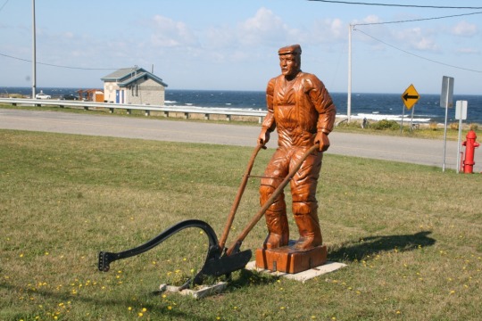
Saturday we motored on along the coast wandering off the highway into some of the villages, one of which was St Felicite. We stopped and had a stroll along the rocky shore where we saw very unusual rock formations and admired the carved wooden statues, then moved on to Baie de Sables, Grande Metis, the Jardin de Metis and Point au Pere at Rimouski. The lighthouse here is the 2nd tallest in Canada with 182 steps to the top! There is also the Museum telling the story of the Empress of Ireland disaster of 1914 then over 1000 people lost there lives when after a collision with a freighter the ship sank in 14 minutes, an occurrence we had never heard of! There is also a de-commissioned Canadian Submarine the Onondaga, which you can take a tour of, but mind your head - ouch! By the time I had done the tour we were thinking of stopping for the night so Rimouski Walmart was where we headed!!
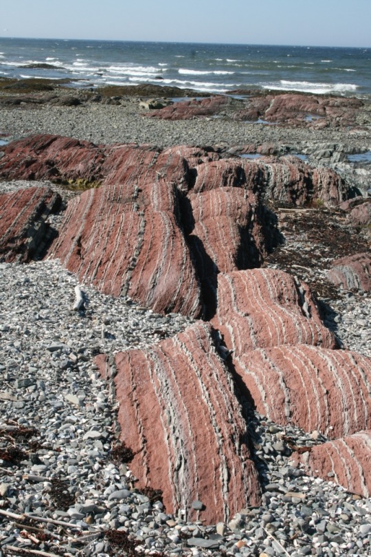
YES, THEY ARE ROCKS!
Sunday we drove the highway for a while then cut off on to the smaller roads through Trois Pistoles and Riviere du Loup, to Beaumont where we had a brief stop. There were some very odd things to see along this road including one house that had a lot of hilarious “sculptures” around it! We got as far as Levis and wanted to get to the other side of the river a Quebec so I put an address into the GPS which took us down into Levis to the ferry! There was no chance of putting the Motorhome on it so I changed the GPS sttings for no ferries and off we went again to brave the many major highways that converge on the bridges over the St Lawrence - not for the faint hearted!! We had got in contact with Sylvain, Nancy’s brother and he had invited us to their home for the evening. Judy and he prepared a BBQ and had called Jacques, Nancy and Sylvain’s Dad to join us. We had a lovely evening with them and it was hard to leave, but there are those who had to go to work in the morning! Not that we went far as we were parked outside for the night!
Monday we said our farewell’s and braved the traffic over the bridges again to get on HW 20 to Montreal. We had a couple of stops at rest areas on the highway and after we turned onto Hw 30 to go around the city we had another brief stop in the Brossard area, then through the toll plaza and onto Hw40 to keep heading West and home. It was getting late in the afternoon and so we decided to find somewhere to stop fot the night, so we headed towards Ottawa but stopped in Hudson and then St Lazare, where we visited Mon Village, a great restaurant that we had been to before when we visited Montreal. Suitably filled up with delicious food, we the headed back down to Vaudreuil-Dorian, and yes Walmart for the night! 417 kms today taking the total to almost 8900 kms so far! Today we will drive the last section home.
1 note
·
View note
Text
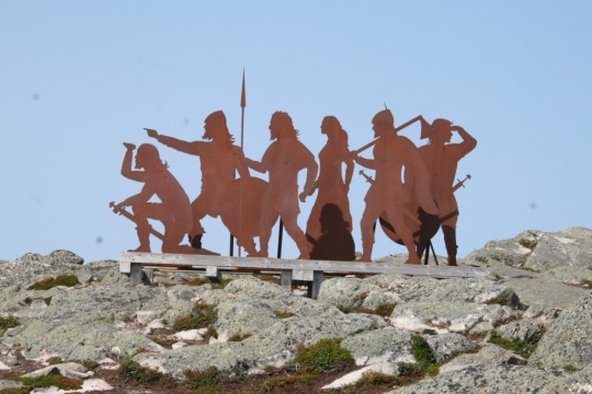
BONAVENTURE, SHIGAWAKE, PERCÉ, and LANDS END!
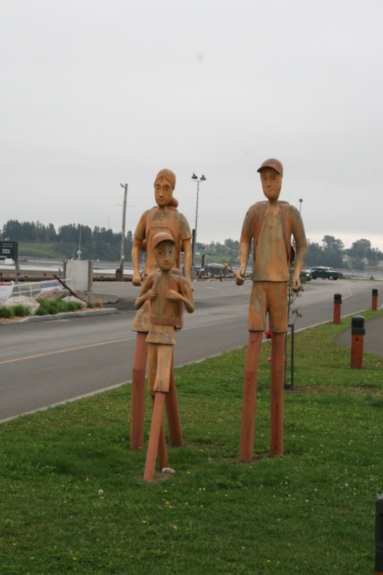
Bonaventure street art!
A misty start this morning but it would soon clear. As we were ready to set off the Campground owner arrived and was so apologetic that we had parked outside overnight. It seemed that in the dark we had missed their open campground a few hundred yards back up the road. She supplied us with a booklet about the region and some advice about things to see, including the shoreline and cliffs below the campgrounds. A very nice lady who (thankfully) spoke pretty good english! We set off for Bonaventure which appeared to have lots to see and do, including (according to the lady in the Visitor Centre) a boardwalk along the shoreline. Well it wasn't a boardwalk and it wasn't on the shore either, but we walked it anyway!! After coffee/tea we drove on to Shigawake to see the waterfall. This meant driving up into the hills on to a mud track to a small area to park then a fair old hike to the falls. It was a tough 20 min hike but worth it when we got there. Then the 20 min hike back up and down the steep hills to the Motorhome and on the road again to Percé where we had a long walk along the beach and back before entering the town proper. There are a couple of islands just off the coast, with sheer sandstone cliffs as you can see from the photo. The town itself is very much geared for tourists with lots of gift and souvenir shops. We decided not to stay in the campsites there and moved on through the Gorge to St George de Malbaie and the campsite there - a much quieter alternative with a lovely view!
So far this region of Quebec has been really worth the side trip. So much beautiful scenery and really friendly and helpful people.
Thursday morning was bright and sunny but it had been a very cold night! We were up early and got some laundry on and Mary had wheaten bread prepared and in the oven before breakfast! We were on the road for 9.15 driving through Gaspe towards Forillon National Park where we stopped at the (closed) Visitor Centre at Penouille and had a good long walk along the boardwalk and path before going down to the beach to walk back, and found Red Chairs! The walk back was lovely, the sound of the waves on the pebbles and the smell of the fresh sea air. As we headed into the Park we could see the Fall colours starting in the hills. We stopped at Plage de Petit Gaspe and watched the seals playing in the beautiful clear waters. On again with a few photo stops to the car park at the end of the road at L'anse-aux-Amerindiens. Another walk down a steep path to the beach then lunch of freshly baked Wheaten Bread before heading out on the hike to Cap Gaspe! We opted for the trail rather than the gravel roadway and the views were spectacular! Part of the trail was extremely steep but we made it up to the top and walked through the forest area to arrive at the old Lighthouse at the point. There is a further trail down to "Lands End", but it was steep with drop offs to the side which we decided would be a little much so we sat in another pair of Red Chairs before starting out on the trail back to the car park. We had walked over 7 kms and were feeling a little tired so we had some coffee then retraced our drive to the park entrance again and drove up and over through the beautiful, colourful scenery (and some road construction!) to the campground at Des-Rosiers for the night. It was another wonderful day in Gaspèsie, as we went to sleep to the sound of the waves on the pebble beach.
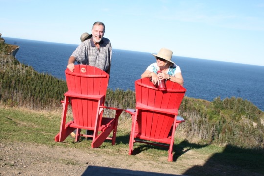
We made it to “Land’s End” !!!
Friday morning we walked down to the beach for a stroll along and to take some photos. A lovely day in prospect. We had decided to backtrack a little to visit the waterfall in the park before moving on along the Northern shore of the peninsula. This part of the drive is through hills and valleys twisting back and forth along the coastline, and taking in the beautiful fall/autumn colours which had us oohing and aahing constantly. We stopped in Grande-Vallée for a walk along the beach before having lunch beside the river. On the road again soon hugging the coast at sea level with the cliffs on one side and the Gulf of St Lawrence on the other. This twisting road became really slow with constant sections under construction, some with traffic lights that seemed to take forever to go green! after some 230 kms and feeling it was time to stop we pulled in to a campground at Cap Chat for the night, and enjoyed another stroll along a beach before watching the sun sink into the sea!
2 notes
·
View notes
Text
THE ACADIAN COAST TO GASPE
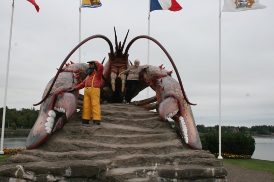
The Giant Lobster at Shediac
We left Amherst Sunday morning and backtracked a little to get to Port Elgin and onto the Acadian Coastal Drive. Cape Pele frustrated us in that we couldn't find a way to get to the beach, but we did find Parlee Beach a bit further up the coast and stopped there for a long stroll on the sand. A popular place in Summer based on the huge parking areas and facilities! In Shediac we found a great open air market and while we admired the produce, the hot food, and the artisans work we came away empty handed. We of course had to visit the Giant Lobster here too!! The coastline along this stretch is very picturesque! A short stop at Cocagne for refreshment then after the diversion around Bouctouche (bridge replacement) we stopped again at the Irving Eco Centre La Dun, which is on a long sand spit out into the Northumberland strait. This is a protected area with dunes and marshes through which there is a 900m boardwalk from which you can watch the birdlife among the Marram grass and other plants. On the road again past Cap Lumiere to Rexton where we left the Coastal Drive as it was getting late in the day, and took the main highway over the huge bridge over Miramichi river in to the town itself and our stop for the night. Unfortunately the part we skipped was through Kouchibouguac National Park but there you go!
A damp start to Monday and a frustrating 10km round trip to the visitor centre which was closed for the season and back on the Coastal Drive having got a very needed propane fill (the motorhome, not us!) to Neguac where just on the edge of town there is a great little park area and a boardwalk with info boards around the salt marsh (and a lighthouse). The drizzle seemed to stop today every time we got out for a walk so another nice walk around and some education too! At Shippagan we had a lunch stop at a lovely park on the waterfront, then on again up the peninsula and over the bridges to Miscou Island. Here we found a visitor centre that was actually open and had a chat with the lovely french speaking lady there. We drove down to Miscou Beach (yes we like beaches as well as lighthouses!) where we beachcombed among the sand, driftwood, seaweed and stones before driving up to the end of the island and the 160+ year old wooden lighthouse. A wonderful old building with 70ft hand hewn uprights of Pine brought in from British Columbia and soaked in seawater to preserve them. The view from the top was awesome! The only sad sight was a beached whale which was being examined to find out what happened to it. Back on the road again we drove back down through Shippagan and on North to Caraquet and the campground there for the night.
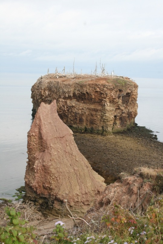
The unusual rock formations at Pokeshaw
Tuesday we moved on, stopping at Pokeshaw to view the sandstone columns and the weird little island. We went down to the beach for a wander and a closer look at the sandstone, then on towards Bathurst where we spotted Daly Point Nature Reserve. We walked some of their many trails before moving on to Bathurst itself, then on through Beresford, Nigadoo, Belledune and Dalhousie to Campbelton. The last section of this journey we could see across to Gaspe and the mountains there, but the area we went through was very industrial so not particularly picturesque! A brief stop to replenish the drinking water then across the big bridge into Quebec and the Gaspe Peninsula. Again the visitor centre just after the bridge was closed so all we had to go on was our big book map which isn't very detailed. What a lovely surprise we had travelling East along this first part. It is beautiful! The scenery, the villages all beautifully kept. We had some brief stops along the way through Escuminac, Maria, Carleton-Sur-Mer to New Richmond where we had planned to stop for the night but the campground was closed. We watched the sun go down over the bay then travelled on looking for somewhere to spend the night and ended up in Caplan, where we parked up outside Camping Ruisselet since the place seemed closed.
3 notes
·
View notes
Text
PICTOU AND A RIGHT TURN TO PRINCE EDWARD ISLAND
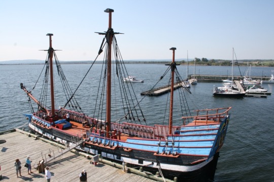
THE HECTOR, PICTOU, NOVA SCOTIA
We said farewell to Camp Walmart at Antigonish and on the way back to the Trans Canada we spotted people lining up at a truck advertising fresh Haddock etc so we stopped and bought 2 lbs of fresh Haddock for $14! Off again to stop in Pictou to visit the "Hector Quay" where a replica of the ship which carried the first Scottish settlers here is berthed. Almost 200 men, women and children braved 12 weeks across the Atlantic Ocean in appalling conditions in a very small ship with the hope of finding a better life in the New World away from the poverty they were suffering under King George II following Culloden. There is a centre giving details of the ship, and the names of all it's passengers and descriptions of what they left in Scotland and what they found in Nova Scotia, which was not what they had been promised!!
After touring the centre and the ship it was a last minute decision to turn right for the ferry to Prince Edward Island. We had visited PEI in 2011 and toured the Eastern coast before running into a spell of rain which was to last for a week, which sent us scurrying to the bridge to New Brunswick and the journey home. This time, when we landed we turned West towards Charlottetown but a wander off down to Point Prim and yet another Lighthouse stopped progress. It was a beautiful setting, looking out West over the Gulf of St Lawrence at the tip of the peninsula, and having chatted to the volunteers who look after the Lighthouse and gift shop, it turned out that it was fine if we wanted to park there for the night and watch the beautiful sunset. So that is just what we did and it was so peaceful sitting watching the seals as the sun sank down into the sea.
Friday morning we awoke to a bright blue sky and sunshine again. Once on the road again we had a brief stop at a farm stall to buy some new potatoes dug from this wonderful red soil, and yet another stop to buy freshly picked apples (10lbs!) (we did taste some first!) and some other fresh veggies before venturing across the bridge to Charlottetown, and a short stop to replenish our water supply. Then it was on North and then West along the Northern Shore, stopping first at Tracadie Bay for a short walk, then on into the Brackley- Dalvey National Park where we stopped again for a walk along Dalvey Beach, where we dipped toes in the water, then at yet another lighthouse before a longer stop at Brackley Beach. This is a huge long beach backed by dunes, with lovely big waves meeting the sand. We had another long walk here and on the way back decided to risk getting more than the toes wet, so after a quick change it was back to the beach and into those super breakers. It was wonderful! When we emerged from the water grinning, feeling so refreshed we were glad we had done it. The water was much warmer than we expected too!
After some lunch we set out again and out of the Park to continue to follow the Central Coastal Drive, as far as North Rustico where we had some coconut ice cream before driving on to eventually get to Summerside, the second city of PEI. We got a few essential groceries before heading out on the start of the North Cape Coastal Drive as far as Green Park Provincial Park, our stop for the night. Another wonderful day!
Due to lack of internet access, we didn’t get this posted so I will add today’s (Saturday) travels.
We drove around the bay from Green Park to Lennox Island, home of the Mi’kmaq First Nations in this area. We intended to visit the Cultural Centre to learn more of these peoples, but despite the info in the books it was closed. We visited the gift store and had a good chat with the guy there, and we read the info boards outside the centre, but it was a bit disappointing.
On the road again we headed North up to North Cape, (another Lighthouse) but really all there was there was a large wind farm and an interpretation centre about wind power generation. Along the way we picked up some local corn, some of which we had with dinner tonight. Driving South again we ended up at the 12.9 km long Confederation Bridge back over to New Brunswick, but ended up in Amherst, Nova Scotia for the night!! Tomorrow we will correct that diversion and get back on to the Acadian Coastal Drive in New Brunswick!
4 notes
·
View notes
Text
Moving on from “The Rock”

The little ferry from Newfoundland to Nova Scotia
Monday morning dawned with still more rain and low cloud so Signal Hill was going to be missed! We got on the road after a leisurely breakfast, towards Argentia and the ferry port. An interesting place Argentia which we should tell you about another time! We arrived at the terminal around 1.00 pm and whilst it was a little brighter and less rain, the wind was howling. The check in staff who have to measure the length of the vehicles were having difficulty keeping their hard hats on! But they were all cheerful, smiling and welcoming! We had a long wait as the ferry was not due to depart until 5.00 pm, but that was fine.
We had booked a cabin for this overnight 16 hour trip so that we could hopefully get some sleep, and were very pleasantly surprised about how roomy it was en suite. We settled in and had a very nice dinner in the buffet rather than the a la carte restaurant which was also available.
Tuesday morning arrived in North Sydney and no improvement in the weather so we drove on as far as Baddeck where things were looking much brighter. Then on again across the Canso Causeway to leave Cape Breton Island and travel to the Northumberland Shore and Antigonish for a stop at Camp Walmart! We now had lovely sunshine and blue skies, such a relief after all the rain!
Wednesday morning we walked the 4.8km trail along the inlet and wetlands at the edge of the town. This is also a bird sanctuary and we saw a variety of birds enjoying it all including a bald eagle! Then it was back on the road to travel North up the coastline towards Cape George, stopping on the way at Mahoneys Beach, where we walked along feeling the sand between our toes, admiring all the lovely rounded stones before dipping our toes in the surprisingly warm sea. Cape George was our lunchtime stop. We strolled up to see the lighthouse (yes another one!) and enjoy the views over to Cape Breton. Driving on again, towards Little Harbour and the lovely beach at Melmerby, where we again walked in the sand and found the water a little cooler!
We then made the mistake of continuing on along the coastal route to Pictou Landing and on to Trenton and New Glasgow. The road was terrible, and we couldn’t see any sign of the sea that we were so close to! From New Glasgow we got back on the Main Trans Canada Highway back to Antigonish for the night. The weather was still lovely with temperatures in the mid 20s even at 7.30 pm!
3 notes
·
View notes
Text
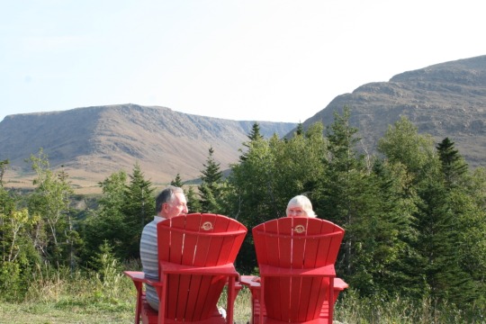
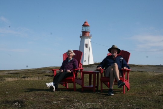
St John’s and Cape Spear
Red Chairs again at Cape Spear.
Thursday night was not a great night for sleeping! The temperature was still up in the low twenties but the humidity was high, coupled with very strong gusty winds which shook the motorhome to such an extent we were concerned that we would tip over! Thankfully that didn’t happen! The morning started with an exciting visit to Mr Lube, as an oil and filter change was a little overdue, plus the fuel filter and a few other bits and pieces.
Then it was off downtown to the Railway Coastal Museum, which was in fact very interesting indeed, then a walk through the the town past the port where Oceanix were busy with a container ship and some oil rig supply vessels were moored. We weren’t aware that there was an oil field out on the Grand Banks off Newfoundland. We stopped for a bite at a cafe and whilst there the heavens opened and the rain just poured down...timing is everything!!
After a further wander we went to visit the other attraction we had read about the village of Quidi Vidi just a short distance away. Mary wanted to visit the Village Plantation which is a place where local artisans ply their craft, set right in the heart of this historic fishing village. I on the other hand wanted to visit the Quidi Vidi Craft Brewery, to have the tour and the tasting of their wares! Those who have been following this blog will remember I sampled their 1892 Ale in Woody Point, Gros Morne. Unfortunately they had none of the 1892 bottled for sale :-( That was it for the day.
Saturday is best described in one word WET. We visited the St John’s Farmers Market and bought a few veggies, but as it is forbidden to take any form of root veg off the island we couldn’t buy much.
We then drove up to Signal Hill, but the cloud had descended and we couldn’t see the top of the hill so we went into the Johnson Geo Centre which is built into the hill there. This really is a must visit when in St John’s. There is so much to see and learn as you go deep underground to experience the story of our planet, this province, people, future and space, too much to describe here! Having spent a few hours there we thought we should see if there was any chance of seeing anything at Signal Hill so we drove up to the top and could hardly see the road in front of us let alone the hilltop or the views, so sadly we drove back down again.
We spent the rest of the day trying to stay out of the rain by doing some window shopping in malls etc.
Today, Sunday, was no better weather wise so we spent the morning relaxing for a while, then Mary made pancakes with Maple Syrup so that brightened things a bit! We decided to see if Cape Spear would be visible so we drove out that way through the murk and low cloud to find that the cloud had lifted here and the rain had eased off! So we walked out to the most easterly point in Canada where we found the Red Chairs in the photo! We watched and listened as the waves crashed into the rocky shoreline before climbing up to the historic Cape Spear Lighthouse, the oldest surviving one in Newfoundland and Labrador. We toured the lighthouse then back to the car park for lunch and a lazy afternoon sitting reading whilst the rain teemed down again! Then it was back to St John’s for our last night on The Rock.
3 notes
·
View notes
Text
Terra Nova and Bonavista Peninsula
Tuesday started off a little cloudy but we set off to walk along the Coastal Trail at Terra Nova. Quite hilly in places but a lovely walk to a waterfall and back, around 6 kms total. Then it was on the road again travelling on the Trans Canada as far as Port Blandford and on to Hw 233 across to Lethbridge, and the took the 230 up the Bonavista Peninsula to Trinity, a quaint old village originally settled by the British. There are many old properties which have restored or retained as they would have been at the time. Very interesting place. We had a couple of ventures off the main roads here which turned out to be not such a great idea as the roads were pretty bad. Our stop for the night was to be Lockston Provincial Park, which, it turned out, was 5kms up a very potholed gravel road. The guy at the Park referred to the road as being “less than perfect”! Lovely Park with great facilities so got some laundry done at last! Fantastic sunset, reflected orange on the Moon!
Wednesday meant another 5kms on that “less than perfect road” to bring us down to Port Rexton and the Skerwink Trail, a 5.3 km path though trees and boggy areas to the coastal part along cliffs with fantastic views over the ocean, finally down to a pebble beach which was the icing on the cake with the waves crashing on the rocks and shore; what a sound.
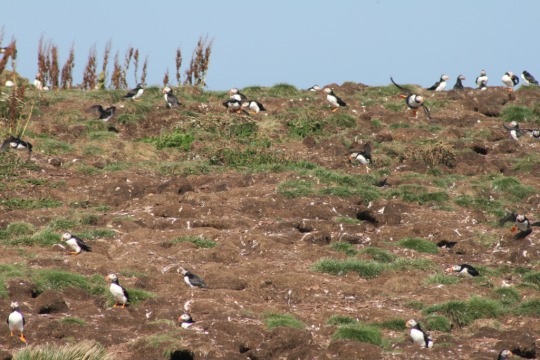
After some refreshment it was on up the peninsula to Elliston where we had a chance to view Puffins nesting on an island very close to the shore. We spent a long time here just watching these wonderfully comical birds fly, swoop and land, hop around their nesting areas and try to chase away pesky gulls trying to raid their nests. Finally we left the Puffins and travelled the short distance back to Sandy Cove, a lovely beach area, where we had lunch.
Our next stop was Cape Bonavista and the rather unique old lighthouse there. Unique in that the tower was built first and then the keepers home built around it as opposed to separate as is usual. A very interesting home indeed!
We left the Cape and the Peninsula and got back on to the Trans Canada as far as Clarinville and our stop for the night at Camp Walmart! Typically we then found out that there was an excellent chance of seeing the Northern Lights that night, provided you were in a dark place, which we were not. Hrumph!
Today, Thursday, our goal was to get to St John’s (St Jaans!), which for the first hour was pretty hairy in thick fog, but we made it safely! Mary wanted to visit the Memorial University Botanical Gardens so that was our first stop. We wandered around the gardens seeing plants we knew and many more we didn’t and taking in a short trail through part of the larger area. We needed to do some grocery shopping so that was the next priority. Late in the afternoon we took a drive out along the northern part of the Avalon Peninsula ending up at a lovely little bay at Flatrock. We sat and had coffee looking out over the bay, the flat rocks, the waves and the gulls, before turning back to St John’s and Walmart for the night.
We have decided not to drive the 900 odd kms back across the island to the Port aux Basque ferry and have opted to take the much longer ferry trip (15 hours) from Argentia back to North Sydney in Nova Scotia, so we are booked for Monday evening which gives us a few days to explore the parts of the St John’s and area that we want to.
1 note
·
View note
Text
The Wild Atlantic Coast
Saturday morning was bright and sunny although a tad cool at 12 c. We drove the short distance up to Long Point to see the lighthouse and walk the trail to “Nanny’s Hole”. A lovely walk with stunning views out over the ocean and the cliffs. The lighthouse included, in the old Keepers home displays of the native birds, whales and fish of the area, as well as some history of the lighthouse and the fishermen. We were able to climb up to the top of the tower where the light is and enjoy the view! No sign of any whales and it was too late in the summer to see any of the Icebergs that sail past here from Greenland every year.
We toured around Twillingate and along the various small roads around it enjoying the scenery, the old (and new) houses, the fishing boats large and small, and the old churches. At one church we noticed the ages on the headstones in the graveyard. Some were for children of 12 and 13 dating back to the 1870s, and of young fishermen caught in storms. Very sad reminder of what risks these men take to earn a living.
On our way back to the campsite we stopped off at the fish market and picked up some lovely fresh cod and salmon, which we then sampled over the next 2 nights! Lovely!!
There are a few artists who live in Twillingate and we stopped to see and in one case buy some of their work. We were able to chat with the artists and get something of their story. Scot Lewis is a Graphite Artist and creates amazing pictures using pencils, and Ted Stuckless is a Fine Artist and his work is just awesome! (check them out on Google!)
As the afternoon was turning to rain we headed back to our spot for the night.
That night was very cold and when we got up it was still only 10 c! We left Twillingate early to drive down the peninsula and then turn East to Farewell and the ferry to Fogo Island. We were at the “terminal” at 9.am as we wanted to make sure we got on board as it is a first come first served service. We were first in line! Not really a surprise as the ferry wasn’t due to leave until 11.30! Fogo is a small but picturesque island with small fishing communities and few roads! The only campground on the island is on the northern end at Brimstone Head just north of the town of Fogo. This headland was considered by the Flat Earth Society as one of the four corners of the Earth! We first visited the National Heritage District of Tilting, which is very much an old Irish settlement. While there we took a walk on the Turpin Trail along the coast. On our way back from Tilting we got a view of the exclusive (and weird looking) Fogo Island Inn, where a suite for 2 starts at Cdn$1875!
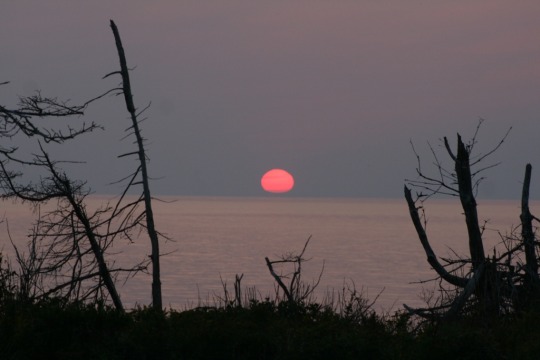
Back at the campsite on the shores of a small bay facing West, having climbed almost to the top of Brimstone Head, we relaxed looking out over the ocean and reflected on what had been a beautiful sunny cloudless day, then enjoyed some of the salmon we had bought and watched the sun sink into sea!
Monday morning we drove around to Fogo Head and this time we made it to the top of the headland (380+m), out of breath but happy to have made it to see the views! Back down at sea level again we drove down to Deep Bay and Island Harbour 2 more of the fishing communities, then it was retrace our steps to catch the Ferry back to Farewell. After a lovely morning, the weather had turned wet again so the drive down to Gander and back on to the Trans Canada to Terra Nova National Park for the night was less than pleasant! We have now driven a total of 4560 kms since leaving home!
3 notes
·
View notes
Text
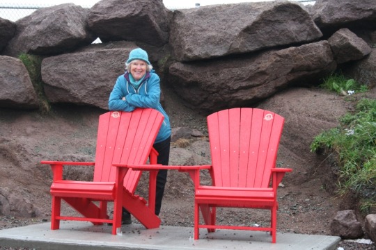
IT’S THOSE RED CHAIRS AGAIN!!
Yes we found some of the Parks Canada 150 Red Chairs again, this time in Tablelands!
So since the last blog we headed south again from Port au Choix stopping first at the Arches Provincial Park which is an outcrop on the shore which has been carved out by the wind and waves. They stand up out of a beach covered in round smooth stones and rocks of all sorts of colours, and no, once again we didn’t take any to bring home!! Then it was on down into Gros Morne again and the Berry Hill trail which wound up to the top of a cone shaped hill with superb panoramic views all around. On the road again and around to the southern portion of Gros Morne National Park, the Tablelands. We travelled all the way down the peninsula to Trout River, a lovely little fishing village where we stopped and had an ice cream, then back across the mountains to Woody Point where we had a wander and called in to a local hostelry where we enjoyed fresh cod and chips, lovely! I also tried one of the Newfoundland craft beers, from Quidy Vidi, a very nice Ale it was too! Our spot for the night was on the shores of Bonne Bay at Shoal Brook.
Thursday morning we were up and out early to go up onto the Tablelands Trail, a 4km hike up into the amazing desolate landscape of very brown rock. The minerals in the Peridotite rock include nickle which id toxic to plants thus vegetation was sparse. We then said farewell to Gros Morne and the Western Peninsula and got back on the Trans Canada Highway at Deer Lake to head East to our stop for the night at Kings Point/Rattling Brook again on the water’s edge. Rattling Brook is and 800 ft waterfall which proved to be interesting getting the RV parked! The weather was turning rather cool now and we had rain overnight and through our journey on East today, Friday. That together with the potholed roads on our drive up to tonight’s stop at Twillingate made today rather tiring! However now the sun is shining and we are looking forward to some sightseeing tomorrow.
3 notes
·
View notes
Text
L’ANSE AUX MEADOWS & NORSTEAD
We had quite a day today! We drove the short distance to the L’anse aux Meadows UNESCO World Heritage Site, where in the 1960s it was discovered that there had been a Viking settlement which has been dated as around 1000AD! We joined with a group of other visitors and were guided through the site by a Parks Canada guide, who has lived in the immediate area all his life. He was able to tell how he and his friends played on the site as kids and that it was referred to as an old Indian place. He remembers the Scandanavian Archeologists who came to the area in the 60s and started to excavate the site and the discovery of artifacts that proved that the Vikings had indeed been there over a period of around 10 years. We then visited the nearby reconstructed village which was carefully built using similar techniques and materials based on what had been discovered at the site. The village also had re-enactors in costume and very much in character to portray what it is believed life was like there at that time. We spend over 2.5 hours there and it was wonderful!!!
We then drove a little bit down the road to where the regional group had built a replica of a similar village called Norstead. This too had re-enactors all of whom were local and who told further of what life would have been like for the settlers. Again a really interesting place to visit!
All of this had taken us well in to the afternoon, so it was back on the road to continue to follow the loop at the north end of the Western Peninsula down to Roddickton and Bide Arm where we intended to stay for the night. Unfortunately we were unable to find any sign of the small campsite that was supposed to be there. After much deliberation we decided that although it was around 6.00pm we had little choice but to head on a further 143 kms to Port au Choix again for the night.
All in all we drove 317 kms today and have covered over 3300 kms since leaving home!
4 notes
·
View notes
Text
Monday 28th Aug
Had some problems getting the previous post to work so we are now at the end of the day and are overnighting at the top of the Western peninsula of Newfoundland some 700 kms North of our entry point of Port au Basques! We had a a great morning first of all going down to the rocky shore in front of our pitch and looking at the amazing rock formations, the crashing waves and the huge quantity of bleached driftwood that has been washed up in this part of the Gulf of St Lawrence. We then drove out past Port au Choix to Point Riche, another National Historic Site where there is another old Lighthouse. We took the walking trail to Philips Garden, which took us along the headland. Again the rock formations, the waves and the wonderful sea air filled us with great joy! Mind you after a 6 km round trip hike we were a little tired!! Then it was off on the road again north up the 430 to St Barbe, where the ferry to Blanc Sablon and into Labrador leaves. We didn’t take the trip over today, but who knows when we are on the road back south again! Our destination today was based on tomorrow’s visit to the L’Anse aux Meadows National Historic Site, where in 1000 AD the first Viking Settlement in North America was established. So tonight we are in the Viking RV Park feeling somewhat dwarfed by the huge 40+ ft American motorhomes that seem to fill this small park!
Relaxing in the Canada 150 “Red Chairs” at Point Riche, Newfoundland
3 notes
·
View notes
Text
WILD AND WINDSWEPT
This was our view this morning, looking out over the Gulf of St Lawrence, just outside Port au Choix. Temperature is 15.9c but the wind isn’t cold
To catch up, Saturday afternoon we were in Gros Morne National Park a huge and beautiful place with the sea on one side and the Long Range Mountains on the other. It’s a UNESCO World Heritage Site. We drove down to Norris Point and visited the Bonne Bay Marine Station and Aquarium where they are studying everything aquatic! Then through Rocky Harbour, couldn’t find the campground, so we headed on North through the Park and stopped at a picnic area at Western Brook River. There was a trail down to a beautiful white sandy beach. On the road again to Cow Head and Shallow Bay where we stopped for the night.
Sunday morning we walked the Lighthouse trail from the RV Park, a 40 min loop to the old lighthouse and back. Then drove back down to Western Brook Pond, to walk the 2.7 km trail through peat bog and scrub (on good paths and boardwalks!) to the Pond and the boat trip we had booked. Western Brook Pond is a land locked Fjord cut by glaciers with soaring 2000 ft cliffs and a depth of over 500 ft! The boat trip was 2 hours of gazing at the beauty and wonder of it all! Incredible experience.
Back on the road again and north to our campsite at Port au Choix. What a day!
So today we will explore the Port and then see where the road North takes us!
Ԙ�\`�
4 notes
·
View notes
Photo
Our view tonight. Shallow Bay, Gros Morne National Park, Newfoundland.
3 notes
·
View notes