
A mostly water based world undergoes the biggest volcanic eruption in the universe, which leads to a new hierarchy and the thirst for water.
Don't wanna be here? Send us removal request.
Statistics
We looked inside some of the posts by unlikelymakerpaperpersona and here's what we found interesting.
Average Info
Notes Per Post
1
Likes Per Post
1
Reblog Per Post
0
Reply Per Post
0
Time Between Posts
7 days
Number of Posts By Type
Photo
9
Text
7
Last Seen Tumblr Blogs


Fun Fact
Average visit duration of Tumblr.com is 10 mins and 25 secs.
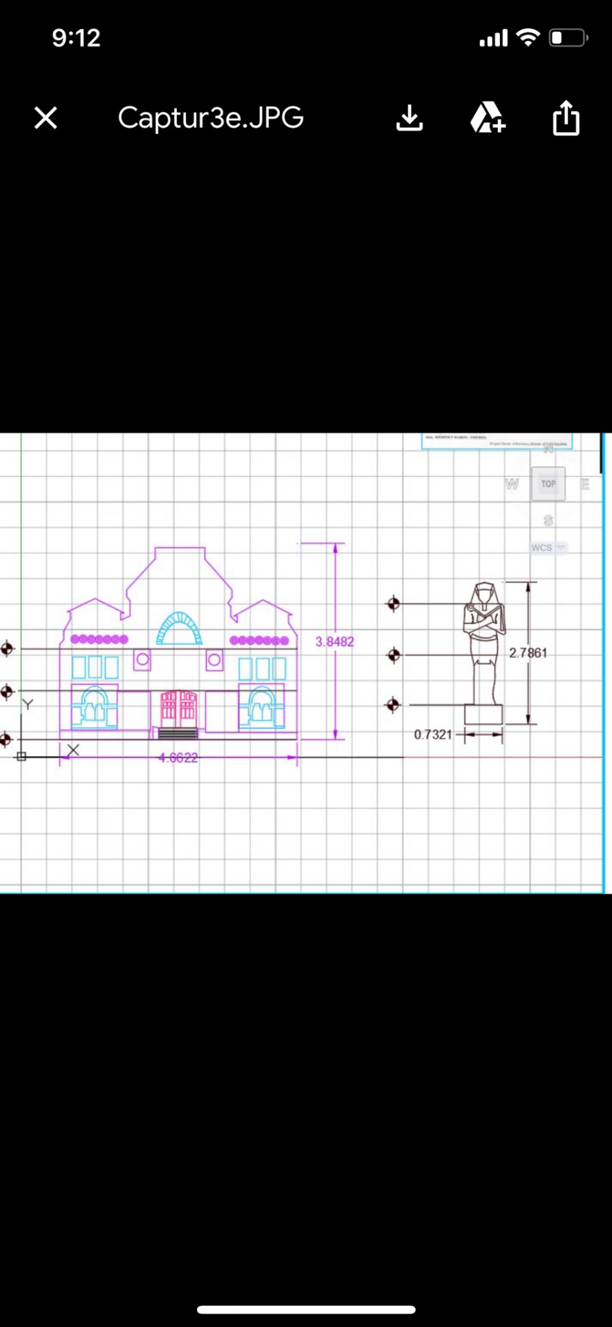
Photo


First image: Plan of outpost
Second: plan of site
third: section of outpost
Fourth: map of world
Fifth: Axo of outpost and site
Sixth: section of site
Seventh and eighth: perspective views
0 notes
Photo


The first picture is of my whole site with my outpost in place which is an enormous water tank where on the first half of the tank is where about 5 people live. Their job is to put the water in the different tanks that surround the tank. One of the tanks is for rainwater, the other for the sewers to recycle because they do not have enough water to replenish it and the last tank is where the clean water is and then they recycle the water and put it in the four different tanks that are connected by tubes and they go underground for the different houses, but mostly goes to the rich. The second half, under the railing, is where 3 people work and live to ensure the fracking system is in place and is running smoothly, furthermore they ensure no one is stealing the water. Moreover, there is an invisible fence around the columns that are laser beams to ensure robbers are dealt with. For the workers there is a small garden within in the tank where they grow food, they receive free water, and they have bunkbeds and washrooms as well inside the tank.
The model that would best represent my idea would be a sectional model because it shows how the outpost works while also showing the history of my site. The outpost has a fracking tube, which goes all the way down the contour lines to where the water is. Furthermore, the model shows the different layers and history of the site. In sectional model I created a dotted box where the water used to located when it was a water world, but then because of the trading of water to be their main resource and global warming it caused an enormous draught for more than 10 years so that is where is the sand is located now and under that is a clay and rock, but underneath that is water. Furthermore, there are some houses that are buried in the sand, which shows the consequences to those that use too much of their water and those who used an illegal fracking system that led the water to go into their house directly. Therefore, the sectional model shows the story of the site and the civilization visually very well.
The fabrication tools I will be using are laser cutting and 3D-priting. I will be laser cutting my topography because it is layered very well and the contour lines will be very easy to see to cut and the edges are sharp so the cnc machine will make those edges more round, which I do not want my site to look like. Furthermore, for the rest of the site I would use 3D printing because my shapes are not very complicated, but they are many of them and 3D printing will show the details of buildings and the outpost very well. However, for the building that are for the rich are made of wood so I would lasercut the bottom where the cube is, but the dome would be 3D printing because it is a big window with a wooden frame.
The elements that would be done by hand will be sanding down any rough spots to ensure everything is smooth. Furthermore, I would paint and use markers to make any detail to the model to make it more realistic and detailed.
I did a laser cut model of my topography to successfully fabricate my site. I had to re-scale my buildings to ensure the 3D printer could make them and lastly for the little buildings I had to make a file of the cube with an open big sphere shape on top, but I would be 3D printing the dome so I would re-scale that.
0 notes
Photo


The first image is after 25 years and the the world is now undergoing a lot of change after being in drought for 35 years now. There has been constant lighting for the past few years, which led to a lot of deaths because the people who were mining for the water got electrified and because there are no hospitals for the poor almost the whole population has died. The lightning in this world works the opposite of earth so the lightening goes for the ground which is where the poor live. The second image is after 100 years and it has been constantly raining but raining sand and crystals and due to the lack of water there was no trade happening so all the rich left and went to another world, which led the world to be covered in sand.
0 notes
Text


Elevation views on cad and the render version on site
0 notes


Text

This collage shows the different parts of the landscape and how every part is different and how I want to emphasize the topo in the outside to show the overall shape and where the majority of the population lives
0 notes
Photo


this task was quite difficult because of the many stages that had to be done for example how exactly I would place every building, but through the collage that I made it was quite simple to imagine it, but then I realized I could not make floating landscapes for the 3D printer for example, but the end result was just like i images. Nevertheless the render turned out very blurry and not at all what I expected, but it still shows the floating landscapes, which is something I thought was very important to show my idea
0 notes


Photo


These are the topographical lines extruded and softened as well as the heightened image. The process was quite difficult because at first I accidentally put the units in meters instead of millimeters which led the contour lines to load after about 30 minutes and it glitched every time I clicked on anything so I think the file was too big. After discovering this I started over again but with the right units and after adding the contours which took one second it took about 3 times to do the Boolean split because I realized the topography lines did not fit the entire square so there were gaps which led the split to be unsuccessful and I used the rebuild function to fill the gaps in but the image looked very strange so I had to do the first step again which was placing the lines in different location for example lower and more spread out to cover the line of the box. After rearranging it it was successful. And then I deleted the top and it created the soft image. For the second topography lines I used a different method i first patched the lines then I added the box by extrudingcrv like the first one but I used split instead of Boolean split because i wanted to see the difference between them and then I added the contour lines instead of the other way around and then I extruded it. I realized the one I used split for looks quite different than my boollean split one for both the smooth and step topography and I prefer the one with the Boolean split one. Overall it was a very frustrating challenging and long process but it was very fun once I got the hang of it and fun to play around with. Lastly i am mostly happy with the outcome of my topography but I wish I used Boolean split for both of them
0 notes


Photo

This world had an enormous explosion that all of the volcanos deformed which created a very ashy and dusty atmosphere. However through time it became habitable. The green parts are where the rich live the land elevates from the ground due to the less gravitational force than Earth, but still has enough force that people can still live on the ground, but that is where most of the impoverish live. Furthermore, the poor mine for water because the explosion caused the world to flood and then it went to a drought for 10 years now, but through mining and science the rich are able to have water while the poor gets enough to survive the hot temperatures as well as for some nutrients.
1 note
·
View note