
Hi I am Vivan from Princeton NJ. I am 27 years old living with my mom and dad. Recently done my studies, I am composer at Modern Realty firm. I love to go for camping on holidays with my family.TwitterMy Blog
Don't wanna be here? Send us removal request.
Statistics
We looked inside some of the posts by vivianbates and here's what we found interesting.
Average Info
Notes Per Post
0
Likes Per Post
0
Reblog Per Post
0
Reply Per Post
0
Time Between Posts
11 days
Number of Posts By Type
Text
17
Last Seen Tumblr Blogs


Fun Fact
In 2020, Tumblr had 29.4 million users in the US.
Text
Hōlei Sea Arch in Hawai‘i Volcanoes National Park
Hawai‘i Volcanoes National Park protects a changing landscape. This is true from the eruptive developments at Kīlauea Caldera all the way down to the ocean erosion at Hōlei Sea Arch. How much longer will this 90-foot tall bridge of basalt withstand the surf? Take a short walk – 100 yards each way – to Hōlei Sea Arch and see it while you can!
(adsbygoogle = window.adsbygoogle || []).push({});
Hōlei Sea Arch is 22 scenic miles from Kīlauea Visitor Center at the bottom of Chain of Craters Road. From the end of the portion of the road that can be driven (eruptions from Kīlauea volcano have closed the rest of the road), it is a short walk to an overlook by Hōlei Sea Arch.
Leave the turnaround at road’s end (by the bathrooms) and walk a few paces up the continuation of the road, which is open to hikers and cyclists. Arrive immediately at the start of the trail down to Hōlei Sea Arch Overlook. Turn right onto the trail.
The short trail heads toward the edge of sea cliffs east of the sea arch. Trail’s end also boasts a fine perspective up the shoreline to the east, where punchy waves collide with the black wall of basalt sea cliffs.
Cliffs on the coast east of Hōlei Sea Arch
Look west to see Hōlei Sea Arch, a short distance away. The arch extends from the sea cliffs into the ocean like an elephant’s trunk. Hōlei Sea Arch is a natural bridge made of basalt. The lava for Hōlei Sea Arch came from an eruption of Kāne Nui O Hamo, a shield volcano to the northwest. Since the eruption, around 600 years ago, marine erosion provided by the ocean’s waves has slowly carved out the sea arch.
How do waves create an arch? When some layers of lava are softer than others, the soft spots erode faster than the harder rock. Sometimes this differential erosion generates inspired shapes, like the natural bridge at Hōlei Sea Arch.
Hōlei Sea Arch
Hōlei Sea Arch is one of the park’s youngest features, having been created in the last 100 years. Unfortunately, it may also be one of the soonest to disappear. The battering waves never cease washing up the arch. How long can Hōlei Sea Arch withstand the abuse?
Waves aren’t the only threat to Hōlei Sea Arch. A 2018 facebook post from Hawaii Volcanoes National Park suggests that the arch may be standing on borrowed time. “As seen in the picture, a new substantial crack is located where the arch meets the cliff. It was sustained from all of the recent earthquake activity happening on the volcano.”
A crack forming behind Hōlei Sea Arch (photo courtesy of the National Parks Service)
(adsbygoogle = window.adsbygoogle || []).push({});
When Hōlei Sea Arch finally does fall, it should give visitors the opportunity to observe other phases of the geological development of the coastine, becoming a sea stack or a sea cave as the basalt cliffs retreats inland.
Take in views of the 90-foot tall Hōlei Sea Arch (while it stands) and then return to Chain of Craters Road for a 0.1-mile round trip hike with 15 feet of elevation change. A panel by the start of the trail explains that you are close to the start of the Hawaiian Islands:
Just offshore, magma pushes through the ocean floor and new volcanoes come to life. Fueled by a hot spot, colossal volcanoes gradually build from the ocean’s dark depths. At the horizon, about 28 miles (45 kilometers) in the distance, lies the submerged summit of the newest volcano – Lō‘ihi (also know as Kama‘ehu in Hawaiian chants). At 3,180 feet (969 m) below sea level, the sun’s rays never reach its summit. These young volcanoes emerge to form the next new islands.
Hōlei Sea Arch is just a small bridge in one of the world’s longest chains of islands stretching from Lō‘ihi and the Big Island past Kaua‘i to Kure Atoll, over 1,600 miles across the Pacific Ocean. As the plates shift and volcanic islands move farther from the hotspot, they grow dormant and, with the passing of enough time, erode back into the ocean. So it goes.
Hōlei Sea Arch
Hōlei Sea Arch Trail is open to hikers, but closed to pets, bikes, and horses. No permit is required for this hike, but an entrance fee is charged to visit Hawai‘i Volcanoes National Park.
Don’t miss nearby Pu‘u Loa Petroglyphs Trail, 2.5 miles up Chain of Craters Road
To get to the trailhead: Take Hawaii Belt Road (Route 11) to the entrance of Hawaii Volcanoes National Park (which is 30 miles south of Hilo). The park entrance is on the left when traveling from Hilo.
Drive past an entrance station to the first intersection. (Kīlauea Visitor Center is just to the right.) Turn left and drive 3 miles down Crater Rim Drive to an intersection with Chain of Craters Road and the Devastation Trail Parking Area. Turn left onto Chain of Craters Road and drive another 18.5 miles down to the Hōlei Sea Arch Trailhead at road’s end.
Trailhead address: Chain of Craters Road, Hawaii Volcanoes National Park, HI 96778 Trailhead coordinates: 19.29515, -155.0983 (19° 17′ 42.5″N 155° 05′ 53.9″W)
from hikespeak.com https://www.hikespeak.com/trails/holei-sea-arch-hawaii-volcanoes-np/
0 notes
Text
Pu‘u Loa Petroglyphs Trail in Hawai‘i Volcanoes National Park
Pu‘u Loa Petroglyphs Trail puts recent geological history and human history on full display. This level 1.4-mile hike crosses a pahoehoe lava flow to a boardwalk loop through an exciting area with thousands of petroglyphs carved by early Hawaiians. The petroglyphs honor the births of those that lived here hundreds of years ago. This short trek in Hawai‘i Volcanoes National Park is sure to inspire curiosity in the not-so-distant past.
(adsbygoogle = window.adsbygoogle || []).push({});
Pu‘u Loa
Set within the tapered coastal slope of a smooth pahoehoe lava flow, Pu‘u Loa is a small hill called a volcanic pressure dome. Pu‘u Loa was created during an eruption of Kāne Nui O Hamo, a shield volcano to the northwest, which produced a significant lava flow around 600 years ago, sometime between 1200 and 1450 A.D.
The Pu‘u Loa Petroglyphs were carved with stone tools into the thin, hard crust of the lava flow. They bore significant meaning for the Hawaiians who carved them. Pu‘u Loa means “hill of long life.” Some 16,000 of the 23,000 petroglyphs at this site served as ceremonial vessels for umbilical cords after children were born. That‘s right – umbilical cords were placed inside carved depressions and then covered with rocks so that the mana of Pu‘u Loa would honor the children with long lives – hence “hill of long life.” The lineage of thousands of Hawaiian families is connected to this spot.
Pu‘u Loa Trail
Reaching the Pu‘u Loa Petroglyphs requires a short walk on a single-track trail that ventured northeast from Chain of Craters Road. The trailhead is 2.5 miles from the end of Chain of Craters Road by the Hōlei Sea Arch. Puna Coast Trail departs from the south side of the road across from Pu‘u Loa Trail. Don’t take this trail (unless you are looking for a much longer hike). Make sure to set out on Pu‘u Loa Trail from the north side of the road (which will be on your left as you drive down Chain of Craters Road from Crater Rim Drive).
Pu‘u Loa Petroglyphs Trail
The hike to the Pu‘u Loa Petroglyphs takes you on a mostly level, but gently rolling walk across a pahoehoe lava flow. Thankfully for your footwear, pahoehoe is the smooth and ropy type of lava rock, so your passage will not be too arduous. Because the route is sometimes difficult to distinguish from the rest of the volcanic landscape, the path of the trail is marked with periodic rock piles.
Admire the way the lava formed along the trail. The steep side of Hōlei Pali rises dramatically to the north. (This is the escarpment of volcanic rock that you drove down to reach the trailhead.) This hike is about 150 feet above sea level, offering glimpses of the ocean to the south.
Folds in the pahoehoe lava backed by a sliver of the Pacific Ocean
After a third of a mile of hiking, come to an info panel along the trail. If the start of the hike has you wondering – how did people live in this tough landscape? – the panel explains:
Hawaiians, native to these ahupua‘a (land divisions), lived a sustainable lifestyle through conservation and trade. They survived by living off the land and the sea. Although the mountains and the ocean provide ample pigs, fish, and other foods, this lava-covered lowland offered minimal soil and fresh water. This made the cultivation of the ‘uala (sweet potato), a staple of the Hawaiian diet, difficult. The mahi‘ai (native farmers) created pits and carefully stacked rocks in the sheltered corners of lava flows to cradle the valuable soil and moisture required to grow the ‘uala. These simple sweet potato mounds became their gardens. The mahi‘ai nurtured many gardens and controlled the number of ‘uala that could be collected from them. The lives of the community depend upon the diligence, knowledge, and ingenuity.
Look at the landscape around the trail. Can you imagine gardening here?
Continue up the trail, admiring the small details in the volcanic landscape around you. Attentive hikers will start to see circles and other carvings in the rocks. Taking rubbings, or otherwise marring or defacing the petroglyphs is illegal. Leave everything as you find it.
Proceed up the trail to the start of a boardwalk loop, 0.6 miles from the trailhead. A pair of panels along the loop help to answer a couple questions that you might have about the petroglyphs all around the boardwalk.
How were the petroglyphs carved?
Petroglyphs were traditionally made using Pōhaku (rock). A sharp stone was used to peck or incise precise impressions into the lava surface, while a blunt stone created a bruised or abraded image. As the culture flourished, petroglyph styles evolved, and the tools used to create them diversified. Most recent mapping projects have confirmed Pu‘uloa as the largest petroglyph field in Hawai‘i.
Why were the petroglyphs carved? Early Hawaiians did not have a written language, but the petroglyphs show an ability to tell stories through images. Figures resembling people, animals, and tools seem easy to translate into English, while other abstract designs hold hidden meanings.
The petroglyph field is filled with depressions used for a distinct, recorded purpose. These depressions are called puka and were used in rituals for newborns as containers for piko, umbilical cords. The panel includes a description by a Hawaiian named Minnie Kaawaloa who shared her connection to this site:
We come to Pu‘uloa because we want what’s best for our keiki (children). Pu‘uloa holds two of my children’s piko. These Kūpuna (elders) brought them here and created the puka where their piko would rest, sealed under a stone.
Hawaiian parents like Minnie hoped that the mana of Pu‘u Loa, its spiritual guiding energy, would bless their children with long, full lives. The puka also rooted each child to the ancestral lands. Look around the petroglyph field at the many different puka. Each hole was created to hold the piko of a single child. Sixteen thousand piko-related carvings have been counted at Pu‘u Loa. The petroglyph area feels like something-the-opposite-of-a-cemetery, celebrating the beginning of life, while connecting family and place.
Piko puka and other petroglyphs
Pu‘u Loa Petroglyphs Boardwalk
Pu‘u Loa Petroglyphs Boardwalk
Take the wooden boardwalk on a loop through the Pu‘u Loa Petroglyph Field – a large, dense collection of petroglyphs. The loop in the boardwalk is 0.2 miles long and can be hiked in either direction. Clockwise seems to be the most popular route. Stay on the boardwalk and do nothing to disturb the petroglyphs.
As you circle the boardwalk, notice how the piko puka (depressions for umbilical cords) come in many forms along the path. Some are deeper and some are wider. Some holes are in alignment, while others are wrapped by rings. Also among the piko puka are petroglyphs that look like people and others that form mysterious shapes. Although much of their meaning may be lost, the significance of the petroglyphs is obvious. Anything carved in stone must have been considered worth preserving.
Pu‘u Loa Boardwalk
(adsbygoogle = window.adsbygoogle || []).push({});
After completing the loop on the boardwalk, and once you’ve taken time to see everything that you came to see, return down Pu‘u Loa Trail. It is a 0.6-mile hike back across the lava field to the trailhead to complete this 1.4-mile hike with 25 feet of elevation change.
Pu‘u Loa Trail is for hiking only. Dogs, bikes, and horses are not allowed. Defacing the petroglyphs in any way is illegal. This is a hands-off hike. A sign at the trailhead also warns that “volcanic fumes are hazardous to your health and may be life threatening. Do not enter this area if you are a person at risk: respiratory problems, heart problems, pregnant, infants & young children.” Those with concerns can get more information at the Kīlauea Visitor Center.
This hike has no shade and may be quite windy, so plan appropriately. No permit is required for Pu‘u Loa Petroglyphs Trail, but an entrance fee is charged to access Hawai‘i Volcanoes National Park.
See more petroglyphs on the Big Island from Malama Trail in Puakō Petroglyph Archeological District
To get to the trailhead: Take Hawaii Belt Road (Route 11) to the entrance of Hawaii Volcanoes National Park (which is 30 miles south of Hilo). The park entrance is on the left when traveling from Hilo.
Drive past an entrance station to the first intersection. (Kīlauea Visitor Center is just to the right.) Turn left and drive 3 miles down Crater Rim Drive to an intersection with Chain of Craters Road and the Devastation Trail Parking Area. Turn left onto Chain of Craters Road and drive another 16 miles down to the Pu‘u Loa Trailhead, 2.5 miles from the end of the road at Hōlei Sea Arch.
Trailhead address: Chain of Craters Road, Hawaii Volcanoes National Park, HI 96778 Trailhead coordinates: 19.28899, -155.1299 (19° 17′ 20.4″N 155° 07′ 47.6″W)
from hikespeak.com https://www.hikespeak.com/trails/puu-loa-petroglyphs-trail-hawaii-volcanoes-np/
0 notes
Text
Lemon Grove & “M” Trails Loop on Cerro San Luis in San Luis Obispo
The mountain named Cerro San Luis is one of the top places to hike in San Luis Obispo, and its trailhead is actually in walking distance from downtown SLO. If you’re drawn to the large white “M” on the side of the mountain, you’re in luck! Not only is the “M” reachable as an extension of the hike to the summit, but thanks to trail created in 2017, hikers can touch the “M” at the top of a loop. Combine the “M” Trail with Lemon Grove Loop Trail for a 2.4-mile hike with 560 feet of elevation change (with options to extend this hike to 3 miles or more).
(adsbygoogle = window.adsbygoogle || []).push({});
Set out from the Marsh Street Trailhead, just north of Madonna Inn and west of Highway 101 and downtown. Get underway up a grassy slope below Cerro San Luis. After a tenth of a mile, come to a junction where the loop in Lemon Grove Loop Trail begins.
If you plan to summit Cerro San Luis, it’s easiest to bear left toward Cerro San Luis Trail, which passes the “M” Trail, 0.3 below the “M” (adding adding 0.6 miles to the 4-mile round trip hike up the mountain). Venturing left up to the “M” and back is just 1.9 miles round trip. You could also bear left to hike the Lemon Grove & “M” Trails Loop in a clockwise direction. However, the directions offered here travel in the opposite direction for a more gradual approach.
Cerro San Luis above Lemon Grove Loop Trail
Lemon Grove Loop Trail
After a right turn at the first junction, Lemon Grove Loop Trail weaves across an undulating grassy slope, dipping into draws and cresting rounded ridges. Prickly pear cacti dot outcroppings along the slope. San Luis Obispo spreads out to the right. Look northeast across downtown toward the Santa Lucia Mountains. Gaze southeast toward ranches and vineyards of Edna Valley.
At the next junction, 0.7 miles from the start, before the trail meets a grove of eucalyptus trees, bear left up a wide dirt trail named Carriage Road. Note: If you skip Carriage Road and continue around the north end of Lemon Grove Loop Trail, this hike can be extended by 0.6 miles.
Carriage Road goes through two curves like an “S” with views up toward the “M.” The wide trail quickly meets the upper half of Lemon Grove Loop Trail. Cross the trail and rise into the lemon grove that gives the loop its name. Young lemon trees are growing in this historical grove. Have a seat on a bench and gaze across San Luis Obispo toward Edna Valley.
The lemon grove on Cerro San Luis
“M” Trail
The “M” Trail begins from the back of the grove, slipping into an oak woodland. The trail ascends Cerro San Luis, initially flirting along the boundary between the trees and the grasses. Look down on Lemon Grove Loop Trail crossing the slopes below. Gaze north up Highway 101 toward the Santa Lucia Mountains. Cal Poly stands out to the north and the rock mass of Bishop Peak appears as well.
Bishop Peak from the “M” Trail
Eventually, the trail commits to the forest and leaves the fields behind. Wind up switchbacks on a rocky slope shaded by live oaks. Several wooded platforms provide gradual turns as the trail cuts up the steep mountainside (making the route suitable for bikes).
“M” Trail through the oaks
Ascend out of the oaks to an exposed slope with more San Luis Obispo views. Ease through trees one more time, walking over a wooded platform around a rock outcropping that feels like it is floating off the side of the mountain. The impressively built trail then aims right toward the “M.”
Above the “M”
Immediately before you hit the large white letter, the trail passes an unmarked junction. An unmaintained path on the right ascends toward the summit. If you choose to go up the mountain this way, the directions are: bear left at a split (0.1 miles), pass a swing in a tree (0.15 miles), meet a wide trail and turn left (0.25 miles) to reach the summit (0.65 miles).
For the Lemon Grove & “M” Trails Loop, skip past the steep path and enjoy a close look at the “M” with views over San Luis Obispo.
The M on Cerro San Luis
The Cerro San Luis “M”
The “M” on the mountainside is made of concrete and painted white. The “M” does not represent the Madonna Family, owners of property on Cerro San Luis (sometimes called Madonna Mountain). Instead, the “M” represents Mission College Preparatory High School, located in downtown San Luis Obispo beneath the mountain.
Not to be outdone, a couple other area schools have letters of their own. To the north, the Cal Poly “P” can be read on Yucca Ridge. On the other side of downtown, spot “SP” on the slopes above San Luis High School. Beyond regional school pride, the views from the “M” on Cerro San Luis are broad and revealing, spreading across downtown San Luis Obsipo and its surroundings.
Hiking down “M” Trail from the “M”
This is the high point of the hike, but just under a mile of hiking remains. Proceed southwest down the other side of “M” Trail across a sage-covered slope with nice views southeast over Edna Valley. Slip through clusters of oaks and descend into a draw where “M” Trail comes to an end at a T-junction with Cerro San Luis Trail. You will have hiked 0.3 miles down from the “M” and 0.95 miles from the start of the “M” Trail at the lemon grove. Unless you’re striving for the summit (1.35 miles up to the right), turn left to return to Marsh Street Trailhead, which is 0.65 miles away.
(adsbygoogle = window.adsbygoogle || []).push({});
Follow Cerro San Luis Trail through chaparral and oaks. Pass through a gate at the top of the grassy slopes around the skirt of the mountain. Stay to the right through a couple junctions that connect to Lemon Grove Loop Trail.
Switchbacks have been built into the steep slope to make the route a little more gradual. Hike half a mile down the trail to the trailhead, passing the opening junction with Lemon Grove Loop Trail, a tenth of a mile before returning to the parking area.
The basic directions for this loop are:
Start toward Cerro San Luis from the Marsh Street Trailhead (0 miles)
Bear right onto Lemon Grove Loop Trail (0.1 miles)
Turn left up Carriage Road, a wide dirt trail (0.7 miles)
Cross Lemon Grove Loop Trail – the upper side – to enter the lemon grove (0.8 miles)
Proceed out the back of the grove up “M” Trail (0.8 miles)
Pass the “M” on Cerro San Luis (1.45 miles)
Continue to the end of “M” Trail and turn left down Cerro San Luis Trail (1.75 miles)
Stay right past the top of Lemon Grove Loop Trail (1.9 miles)
Stay right again past the bottom of Lemon Grove Loop Trail (2.3 miles)
Return to Marsh Creek Trailhead (2.4 miles)
Hiking all of “M” Trail and some of Lemon Grove Loop Trail creates a 2.4-mile loop with 560 feet of elevation change. Skip the Carriage Road shortcut to see more of Lemon Grove Loop Trail for a 3-mile hike. Hikers are welcome to bring dogs. No fee or permit is required to hike around Cerro San Luis, so get out and enjoy!
A note for mountain bikers: The “M” Trail and the top half of Lemon Grove Loop Trail are open to bikes. The city recommends that bikers take this loop in a clockwise direction (opposite of what is described above). Bikers should take Cerro San Luis Trail to the south end of the “M” Trail and ride the trail northward. At the bottom of the “M” Trail by the lemon grove, bikers should turn right on Lemon Grove Loop Trail to get back to the trailhead, rather than using Carriage Road to reach the lower side of the trail.
To get to the trailhead: From downtown San Luis Obispo, take Higuera Street southeast to Marsh Street and turn right. Pass beneath Highway 101, and turn right on Fernandez Lane (the only road on the right before Marsh Street turns onto the 101 South). Turn right into the dirt parking area. The trail begins at the end of the lot.
Trailhead address: 1183 Fernandez Road, San Luis Obispo, CA 93405 Trailhead coordinates: 35.2749, -120.67235 (35° 16′ 29.62″N 120° 40′ 20.52″W)
from hikespeak.com https://www.hikespeak.com/trails/lemon-m-trail-loop-cerro-san-luis-obispo/
0 notes
Text
Creek Bypass Trail Loop in Reservoir Canyon Natural Reserve
During the late teens of the 22nd century, San Luis Obispo has developed Reservoir Canyon Natural Reserve into a versatile hiking destination, with upgraded trails and features. Reservoir Canyon Trail and Summit Trail deliver great half-day hikes. However, a shorter option exists that packs Reservoir Canyon into a one-mile experience with 150 feet of elevation change. Use Creek Bypass Trail to tie the bottoms of Summit Trail and Reservoir Canyon Trail together, gaining views over riparian Reservoir Canyon, cradled below the Santa Lucia Mountain. Reservoir Creek Falls is a minute up the trail, so get going!
(adsbygoogle = window.adsbygoogle || []).push({});
As its name suggests, Creek Bypass Trail also serves as an alternate route for the bottom of Reservoir Canyon Trail, which can get wet and muddy when Reservoir Creek is flush. During stretches of winter wetness, Creek Bypass Trail becomes the recommended replacement from Reservoir Canyon Trail and this loop stops being an option.
If you’re a self-disciplined hiker, you could save Reservoir Creek Falls for the end of this hike and travel clockwise up Reservoir Canyon Trail, across Creek Bypass Trail, and down Summit Trail to the waterfall and trailhead. The directions provided here take the opposite approach, immediately indulging in Reservoir Creek Falls, and then crossing Creek Bypass Trail toward Reservoir Canyon Trail, in the directions that seems to maximize the trail’s views for hikers.
Reservoir Creek Falls
The basic directions for this loop are:
Set out by the kiosk at the west side of the Reservoir Canyon Road Trailhead (0 miles)
Admire Reservoir Creek Falls (75 yards)
Continue up the slope beside the falls to a junction and turn right onto the bridge across Reservoir Creek (0.05 miles)
At the first marked junction, turn left and leave Summit Trail for Creek Bypass Trail (0.25 miles)
Enjoy a Reservoir Canyon Viewpoint (0.3 miles)
Descend into Reservoir Canyon and turn left down Reservoir Canyon Trail (0.6 miles)
Return to Reservoir Canyon Road Trailhead (1 mile)
Make your way to the large (new) parking area at the Reservoir Canyon Road Trailhead. At the east side of the parking area, and a straight shot off the end of the road, is a gate at the beginning of Reservoir Canyon Trail. Use this trail to finish the loop. Begin instead beside the kiosk at the west end of the parking area.
Walk through grasses into the woods beside Reservoir Creek. Rising in front of you is Reservoir Creek Falls, measuring some fifteen or twenty feet tall. The charming waterfall slides down a slope of black rock into a shallow oak-shaded pool. This waterfall nearly disappears during dry months, but is plenty enjoyable when water is flowing. A tunnel on the right side of the waterfall is a remnant of the old reservoir in the canyon. The tunnel served as an outflow for the dam.
From the waterfall, proceed up the slope on the left side of the falls. Rise to a junction and turn right onto a bridge that spans Reservoir Creek above the falls. Cross the bridge and follow Summit Trail through dense oaks and toyon on the opposite bank. This nicely established single track rises up the side of Reservoir Canyon through a few turns and switchbacks.
The bridge above Reservoir Creek Falls
Follow Summit Trail for 0.2 miles up to Creek Bypass Trail. Don’t get fooled by another path parting to the left, 150 yards up the trail, which is barricaded off and is not the trail you seek. At the next switchback to the left, avoid a small path on the right (this may be a junction for future trail development). Rise through more live oaks to the marked junction. Stop climbing up Summit Trail, toward the tower on the ridge above, and turn left onto Creek Bypass Trail.
Creek Bypass Trail levels out and crosses a slope covered in grasses and low brush. The vegetation presents open views north toward the Santa Lucia Mountains (where hikes on West Cuesta and East Cuesta depart from the Highway 101.
Looking northwest from Creek Bypass Trail
After about 100 yards on Creek Bypass Trail, and 0.3 miles from the trailhead, put the hiking on pause as the trail curves to the right atop a bend in Reservoir Canyon. Stop beside a rock outcropping and absorb a sweeping perspective over Reservoir Canyon. Look out from the viewpoint over the trees growing along the bottom of the canyon. Grass and chaparral-covered slopes frame the canyon, rising into the mountains north of San Luis Obispo.
Gazing up Reservoir Canyon from Creek Bypass Trail
Continue along Creek Bypass Trail, which crosses below cliffs of exposed rock on the wall of the canyon. Cross a gully where a drainage flows down the side of the canyon. When an unmarked path descends to the left, continue straight along the main trail. Oaks appear beside the trail, ushering you down into the canyon. Return to the shade, arriving at stone steps that swing down to the canyon bottom. Cross the creekbed to a T-junction with Reservoir Canyon Trail.
(adsbygoogle = window.adsbygoogle || []).push({});
To the right, Reservoir Canyon Trail pushes farther up the canyon to the ridge above. If you are using Creek Bypass Trail to bypass wet areas lower in the canyon, bear right and venture up the canyon. For the 1-mile loop, turn left down Reservoir Canyon Trail.
Reservoir Canyon Trail passes between the trees sheltered along the creek and the grassy slope on the side of canyon. The trail is wide, but narrows in places where it twists through crossings of Reservoir Creek (where the trail can get washed out after rainstorms). The level trail slips through the shade of sycamores, oaks, and assorted brush.
Reservoir Canyon Trail widens into an old municipal road, a remnant from the canyon’s former purpose as a reservoir for San Luis Obispo. Just before the trailhead comes into view, cross a junction with a trail parting to the left. By turning here, you would quickly reach the bridge across the creek for Summit Trail and the route down to Reservoir Creek Falls. Unless you’re compelled to see the waterfall again, simply walk straight through this last junction. The trail ends at the east side of the parking area where you began, completing the 1-mile loop on Summit Trail, Creek Bypass Trail, and Reservoir Canyon Trail.
No fee is charged to park at the Reservoir Canyon Road Trailhead and no permit is needed to hike in Reservoir Canyon Natural Reserve. Dogs are welcome on leashes but bikes are not permitted. Reservoir Canyon Natural Reserve (formerly Bowden Ranch & Reservoir Canyon Open Space) preserves 783 acres. To spend more time in this city of San Luis Obispo reserve, explore Reservoir Canyon Loop.
To get to the trailhead: From downtown San Luis Obispo, take Highway 101 north for approximately two miles to Reservoir Canyon Road (an easy-to-miss road connecting to the freeway). Turn right and drive half a mile to the trailhead parking area at road’s end.
After the hike, exercise caution when getting back on the highway. It may be safer to drive north and turn around at another exit rather than cutting across northbound traffic to reach the southbound lanes to San Luis Obispo.
Trailhead address: Reservoir Canyon Road, San Luis Obispo, CA 93401 Trailhead coordinates: 35.29075, -120.62775 (35° 17′ 26.7″N 120° 37′ 39.9″W)
from hikespeak.com https://www.hikespeak.com/trails/reservoir-canyon-creek-bypass-trail-loop/
0 notes
Text
Hedge Creek Falls in Dunsmuir
Hedge Creek Falls is a 35-foot waterfall pouring over a basalt overhang into a wooded ravine above the Sacramento River south of Mount Shasta. A short trail leads to the waterfall from a trailhead right beside an Interstate 5 offramp in Dunsmuir, so this waterfall hike makes a great break from highway travel. The fun trail actually passes behind the waterfall, going underneath the overhang, and continues down to a Sacramento River Overlook, resulting in a never-a-dull-moment 0.6-mile round trip hike with 130 feet of elevation change.
(adsbygoogle = window.adsbygoogle || []).push({});
Need a break while driving on I-5? Get off at exit 732 in Dunsmuir, 6 miles south of Mount Shasta. Right at the end of the offramp, find trailhead parking at the corner of Siskiyou Avenue and Dunsmuir Avenue. How convenient is that?
Walk across Dunsmuir Avenue to a dirt trail going into the forest, passing a sign shaped like a train locomotive that reads, “Welcome to Hedge Creek Falls” (you could see an actual train at the end of the trail). Walk 50 yards to a pavilion on the edge of the ravine and bear right down the single track marked Hedge Creek Falls Trail. Descend across a slope through firs and outcroppings of mossy boulders.
Hedge Creek Falls Trail
After a tenth of a mile, come to a switchback bending to the right that offers a bench for taking an early break (the bench might prove more useful if you’re short of breath on the hike up). Look beyond the bench and try to catch a glimpse of Hedge Creek Falls.
After doubling back for about forty yards, the trail turns through another switchback and resumes its trajectory heading northeast. Hedge Creek appears in the ravine below, peacefully tumbling toward the Sacramento River. In no time at all, the waterfall leaps out in front of you. Hedge Creek Falls spills over a thick ledge of columnar basalt and then continues to plunge through an open-air fall into a basin in the ravine.
Hedge Creek Falls
The trail takes you straight to the waterfall, but it doesn’t stop there! A crescent-shaped alcove carved out below the ledge of columnar basalt creates the space to walk all the way around the back of the waterfall. Take in perspectives of Hedge Creek Falls from every angle.
Hedge Creek Falls
Proceeding out from the overhang, the trail continues down the opposite side of the ravine, bordering Hedge Creek for another tenth of a mile to approach a viewing platform that faces the Sacrament River. Pass another bench shortly below the waterfall.
Come to the Sacramento River Overlook, 0.3 miles from the trailhead (and 130 feet lower in elevation). Look out across the Sacramento River, flowing southwest through a bend in the wooded canyon below. Across from the overlook and through a line of trees, spot the Union Pacific Railroad Line and possibly a passing train.
The Sacramento River flows past Hedge Creek Falls Trail
A path to the left of the overlook descends to the Sacramento River, and the prospect of summer swimming holes. Looking right, you should be able to spot Mount Shasta rising above the treetops to the north (unless unfortunate storm clouds steal your view). Footpaths sneak up a short, steep, rocky slope to the right, apparently leading to improved perspectives north toward Mount Shasta and down over the Sacramento River.
Leave the overlook and hike back up Hedge Creek Falls Trail. Pass behind the waterfall a second time and pause to ponder some of its history. Hedge Creek Falls bears the nickname “Million Dollar Waterfall.” When Interstate 5 was constructed, the original plans positioned the highway right on top of Hedge Creek Falls. Protests to preserve the waterfall were victorious and the interstate’s planned path was moved. The relocation added around million dollars in construction costs, and gave birth to the nickname. A million thank-yous…
Looking out from behind Hedge Creek Falls
(adsbygoogle = window.adsbygoogle || []).push({});
If the overhang behind Hedge Creek Falls seems like a decent place to hunker down for the night, you wouldn’t be the first to have that idea. It is believed that stagecoach robber Black Bart hid behind the waterfall before holding up a stage.
Part with Hedge Creek Falls and hike the final 0.2 miles up to Dunsmuir Avenue to complete this outing. Watch out for poison oak along the trail. Dogs are welcome. No permit is required for this hike and parking at the Hedge Creek Falls Trailhead is free, so get out and enjoy!
To get to the trailhead: From Mount Shasta, travel south on Interstate 5 for about 6 miles to exit 732. At the end of the offramp, turn right on Siskiyou Avenue. Then make an immediate right on Dunsmuir Avenue. Pull into the parking area on the right side of the road. Use to crosswalk to reach the Hedge Creek Falls Trail on the opposite side of Dunsmuir Avenue.
From Redding, take Interstate 5 north for 53 miles to exit 732. At the end of the offramp, turn right on Siskiyou Avenue. Cross under the interstate and turn right on Dunsmuir Avenue. Then park in the area on the right.
Trailhead address: Parking for Hedge Creek Falls, 506 Dunsmuir Avenue, Dunsmuir, CA 96025 Trailhead coordinates: 41.23625, -122.2696 (41° 14′ 10.5″N 122° 16′ 10.6″W)
from hikespeak.com https://www.hikespeak.com/trails/hedge-creek-falls-in-dunsmuir/
0 notes
Text
Longridge Park in Sherman Oaks
The Santa Monica Mountains have significant parks with great hiking getaways. Often overlooked are smaller undeveloped pockets within the mountains that offer quick escapes from the stresses of Los Angeles. Longridge Park in Sherman Oaks is the latter, a 50-acre park with a 0.2-mile long use-trail.
Longridge Trail has ridge-top views throughout its short run, like perspectives north across the San Fernando Valley and east toward the Griffith Park end of the range. Another trail highlight is an outcropping of sandstone with striped layers. You won’t burn a lot of calories on this 0.4-mile round trip hike with 75 feet of elevation change. However, if you’re satisfied with short and sweet, Longridge Park is plenty fun.
The beginning of Longridge Trail
Longridge Park is located on the north side of the Santa Monica Mountains in Sherman Oaks, between Dixie Canyon Park and Coldwater Canyon Park. Use roadside parking and set out from the top of Alomar Drive (south of Ventura Boulevard and west of Coldwater Canyon Avenue). A dirt single track leaves from the end of the road, quickly passing a sign to announce that you are entering a Santa Monica Mountains Conservancy Zone Parkland.
(adsbygoogle = window.adsbygoogle || []).push({});
Begin up the trail, passing a cluster of live oaks on the right. The trail quickly swings to the right, going up a rise on the ridge. As the trail turns, it passes a narrow path on the left. For those unopposed to scraping through the sagebrush, this path could be used to form a loop and explore farther in the park. Continue up the trail onto the spine of the ridge, where it curves to the left past an excellent early viewpoint, a hundred yards from the start. Pause to look west over Dixie Canyon and north across Sherman Oaks and other cities in the San Fernando Valley. The Santa Susana Mountains and San Gabriel Mountains rise to the north.
Sherman Oaks below Dixie Canyon
Longridge Trail
Longridge Trail ventures south up two leveled terraces in the ridge. After the second short but steep step in the terrain, cross a field and approach an unmarked junction in front of a shallow trough. One branch of the trail goes to the right, snagging additional views over Dixie Canyon, while the other half of the trail goes straight ahead. Proceed straight for a moment and then look underfoot and off the left side of the trail to observe areas of exposed bedrock with stylish stripes. An upturned crest in the bedrock reveals sandstone that is layered in different shades of yellow and tan. While this is no Fire Wave, it’s certainly a fun feature.
A crest of striped sandstone by Longridge Trail
A crest of striped sandstone by Longridge Trail
Leave the outcropping, 1/8 of a mile from the start, and continue up either branch of Longridge Trail (they quickly reunite). Come to another small clearing where the trail seems to splinter and end. Don’t despair. Proceed up a thinner trail along the west side of the ridge top (keeping the taller brush to your left). March through grasses, looking south up the ridge toward mansions along Mulholland Drive.
Approach a longer clearing, 0.2 miles from the start, which boasts nice views of the surrounding Santa Monica Mountains. Look over a saddle in the ridge to the east to see the tops of Cahuenga Peak and Mount Lee in Griffith Park.
The mountains of Griffith Park from Longridge Trail
To the south, the trail becomes even thinner and harder to trace as it runs into dense sagebrush. Unless you uncover an easy way to advance or dip below the east side of the ridge to loop back to the start (future trails may be developed in the park), it is probably best to turn around at the clearing with the Griffith Park views.
(adsbygoogle = window.adsbygoogle || []).push({});
Although it might feel like you’ve just gotten going, this is the end of the trail! Turn around and hike back through Longridge Park. Ease down the ridge, enjoying broad views across the San Fernando Valley, and return to Alomar Drive.
Longridge Park is operated by the Mountains Recreation and Conservation Authority. The park is open from sunrise to sunset. Dogs are permitted on leashes. Bikes also appear to be allowed. Please pack out all trash (far too much garbage has been dropped along the trail). No fee or permit is required for this hike, so get out and enjoy.
To get to the trailhead: Take the 101 Freeway to exit 15 for Coldwater Canyon. At the end of the offramp, turn south on Coldwater Canyon Avenue. Drive 3/4 of a mile to Ventura Boulevard and turn right. Drive one block and turn left onto Valley Vista Boulevard. Drive 0.2 miles and turn left up Mary Elle Avenue (the 4th left). Go one block, cross Longridge Avenue, and continue up Alomar Drive. Make a left turn at an intersection with Cheltenham Drive to follow Alomar Drive for 0.6 miles up to the trailhead at road’s end.
By mass transit, take either LA Metro bus line 150, 240, or 750 to the Ventura / Valley Vista stop along Ventura Boulevard. Walk a little under one mile from there up to the trailhead.
Trailhead address: 3600 Alomar Drive, Sherman Oaks, CA 91423 Trailhead coordinates: 34.13677, -118.42087 (34° 08′ 12.4″N 118° 25′ 15.1″W)
from hikespeak.com https://www.hikespeak.com/trails/longridge-park-sherman-oaks-los-angeles/
0 notes
Text
Royal Grounds – Pu‘uhonua Loop in Pu‘uhonua O Hōnaunau National Historical Park
To walk through Hawaiian history, head to Pu‘uhonua O Hōnaunau National Historical Park, located on the west coast of the Big Island of Hawai‘i, south of Kona. A convenient hiking trail weaves through the park’s Royal Grounds and the Pu‘uhonua (place of refuge). This half-mile long loop passes sixteen numbered markers that correspond with entries in a park brochure to put an educational spin to the scenic surroundings.
(adsbygoogle = window.adsbygoogle || []).push({});
Set out from the visitor center and walk down toward the coast. Leave the concrete and step onto a pale, crushed rock surface at a three-way junction. One end of the loop is to the left. Another path goes straight. Ignore both and bear right to begin the counter clockwise loop.
The first marker announces that you are on the royal grounds. Be respectful of this sacred site, which was used by ali‘i (Hawaiian chiefs) as a place to host important gathering and ceremonies. Hōnaunau was the home of Kona’s chiefs and the ancestral grounds of the Kamehameha dynasty.
Hiking the Royal Grounds
Walk toward the coast, passing a scaled-down model of the Hale o Keawe temple on the right. You will see the actual temple midway through the loop, but won’t be able to step inside. The recreation is still plenty large, with a thatched roof made of ki leaves.
Straight ahead, find another smaller structure next to the coast. Looking north, people may be visible swimming in a cove just beyond the park boundary. Swimming and snorkeling are not allowed within the royal grounds or pu‘uhonua, but the boat launch and snorkeling area along Honaunau Beach Road just outside the park appear to be quite popular.
The kōnane game on a papamū playing surface
Curve to the left and approach the next few markers. Marker 3 is placed beside a lava rock game board with black and white pieces. This Hawaiian strategy game is called kōnane. The playing surface, called the papamū, can vary in size. Instructions for kōnane should be available at the visitor center.
Beside Marker 4, look at bowls carved into lava rock. Resembling the morteros used by Native Americans in the American southwest, these rock bowls are called kānoa and may have been used to dye bark cloth, tan fishing nets, or make ceremonial drinks. For another lava-formed feature, check out marker 5, where tree molds appear in lava rock in places where palms once stood. The corresponding entry in the brochure explains:
When hot lava surrounds a living tree, moisture in the tree causes the lava to harden before it burns. Sometimes this leaves tree molds like you see here. Many molds in the park are of loulu palms. Loulu were once abundant, but now are endangered.
The trail swings around Keone‘ele Cove (marker 6). This significant cove was reserved for the canoes of chieftains. The brochure asks you to picture paddlers maneuvering canoes around lava rocks in the bay to bring the ali‘i, priests, and advisors ashore in the cove. This VIP area is now reserved for the sea turtles (honu), who drift through the water and hide in the sand along the shore. Admire the sea turtles from a respectable distance.
Keone’ele Cove
Behind the cove is a fishpond, which you’ll pass later in the loop. For now, continue around the cove through a cluster of coconut palms and approach a long black wall made up of lava rocks.
The Great Wall
The Great Wall and the Hale o Keawe
The great wall made of lava rocks separates the royal grounds from the pu‘uhonua, which was a place or refuge in Hawaiian culture. Within the pu‘uhonua, sanctuary and forgiveness were possible. A passage in the brochure explains that the wall was:
Up to 12 feet tall, 18 feet wide, and over 950 feet long, this wall defines the sacred space of the Pu‘uhonua. The wall was constructed over 400 years ago using uhua humu pohaku (dry-set masonry) – stones fitted without mortar.
The dark wall stands out against the light-colored grounds. Walk to the end of the wall to the park’s main feature, the Hale o Keawe, which is fenced off and guarded by ornate wooden statues. This heiau temple is a sacred place for the Hawaiians and is a mausoleum for the remains of 23 ali‘i (chiefs). Tall statues carved in wood are called ki‘i. They represent Hawaiian gods and stand as indicators of the site’s significance.
Walk right up to two of the ki‘i guardians that stand near the water’s edge. Now imagine the impression that these carvings would give off if you were arriving by canoe.
ki‘i guardians in front of Hale o Keawe
At this point, 0.2 miles from the start, you are leaving the royal grounds for the pu‘uhonua. Walk around the temple, passing tide pools on the right where tropical fish like yellow tang swim in the shallows.
What was the Pu’uhonua?
Under the harsh Hawaiian laws of kapu, the punishment for breaking a law was death. Some of the transgressions that could results in death, as listed in the park brochure were:
A woman eating with a man
A commoner casting a shadow on a chief
Someone catching a fish out of season
The only way to avoid punishment was to elude pursuers, run to the coast, and swim to a pu’uhonua. Those who pulled off this feat could be absolved by kahuna pule (priests). After a short time in the refuge, law-breakers that were pardoned by priests would be able to return home.
During wars, pu’uhonua around Hawaii served as outside-the-battle safe spaces for children, elders, and other non-fighters. When wars ended, people from the losing side might seek the sanctuary of the pu’uhonua as well (instead of facing death). Within the walls of a pu’uhonua, no physical harm could come to you.
The Pu‘uhonua O Hōnaunau, like all pu‘uhonua in the islands, served Hawaiians for hundreds of years until kapu ended in 1819. It remains a sacred place of peace, calm, and refuge to Hawaiians, open to all who find their way here.
For centuries, the pu’uhonua provided threatened Hawaiians with a second chance at life, until the kapu laws were abolished in 1819 by King Kamehameha II, the second ruler of the unified kingdom of Hawaii. Today’s visitors no longer need to escape death sentences and be pardoned by priests in order to enjoy the calm refuge of the pu’uhonua.
Walking the loop through the Pu’uhonua (Place of Refuge)
Hiking through the Pu’uhonua
A rugged coastline of dark lava rock and tide pools spreads out to your right as you follow the pale trail southward into the pu’uhonua. A hundred yards from the Hale o Keawe, come to a spur path on the right that leaves the loop trail. The path leads around the rock wall of a heiau, called the the ‘Āle‘ale‘a, which likely predates the Hale o Keawe, and was used by ali‘i as a platform for watching hula.
At the end of the spur path, spot marker 10 beside the Keōua Stone. This block of volcanic rock was a resting place for a high chief. Notice four holes in the ground around the rock, which likely supported a shade canopy. Imagine yourself as Keōua, gazing out over the blue bay and the black shoreline.
Backtrack to the junction and turn right to continue on the loop trail along the rock wall of the heiau. Approach a large boulder of dark red lava. It is believed that Queen Ka‘ahumanu hid under this impressive stone during a quarrel with King Kamehameha.
The trail passes marker 13, where another rock has a carved depression laid out in a papamū board for playing kōnane. Enjoy coastal views on the way to the next marker, at the site of a temple build long ago. Although this old heiau is hard to see, the remnants are believed to be some of of the oldest structures in the park.
The trail now turns inland, weaving toward a forest of palms. Standing out from this natural scene is the black boundary of the great wall. Pass a small pond as you approach the wall. This type of pond is called an anchialine pool, because it is fed by both freshwater springs and ocean water. Continue along the trail toward a modern opening built through the wall, which allows easy passage back to the royal grounds.
Return to the Royal Grounds
The loop trail passes two more numbered markers as it progresses back toward the visitor center. At marker 15, ease between two royal fishponds located behind Keone‘ele Cove. These anchialine pools were used for fish farming. According to kapu, fish harvested from the ponds could only be eaten by the ali‘i.
A fishpond in the Royal Grounds
Just before the visitor center, pass a pair of tall wooden structures with thatched roofs. These hālua serve as boathouses for wa‘a, traditional Hawaiian canoes. Step inside the hālua and you may find artisan Hawaiians getting crafty with natural materials like coconut husks.
(adsbygoogle = window.adsbygoogle || []).push({});
Leave the hālua and close out the loop. When you get back to the start, turn right and walk back through the visitor center to the parking area. For additional hiking in the park, consider the 1871 Trail venturing south down the coast.
No permit is required to walk the Royal Grounds – Pu‘uhonua Loop. However, an entrance fee is charged to visit Pu‘uhonua O Hōnaunau National Historical Park (operated by the National Park Service). The fee is $15 per vehicle, or $10 or motorcycles and $7 for pediatricians and cyclists, and is valid for seven days of entry (prices as of 2019). In lieu of individual park entry fee, an America the Beautiful interagency pass may be used, as well as an annual pass eligible for three Hawaiian national parks (Hawai‘i Volcanoes National Park, Haleakalā National Park, and Pu‘uhonua O Hōnaunau National Historical Park). The park opens daily at 7 a.m. and closes 15 minutes after sunset. The visitor center is open daily from 8:30 a.m. to 4:30 p.m.
To get to the trailhead: From Kona, travel south on Hawaii Belt Road (Hawaii 11) for 8.5 miles. At an intersection with Mamalahoa Highway (Route 180) stay to the right and continue on Hawaii Belt Road, following signs for Volcano. Drive 3.5 miles to Captain Cook and turn left to stay on Hawaii Belt Road at an intersection with Mamalahoa Bypass Road. Drive another 6.5 miles south on Hawaii Belt Road to an intersection with Ke Ala O Keawe Road (Route 160) and turn right, following signs for Pu‘uhonua O Hōnaunau.
Traveling in the opposite direction as Kona, the intersection with Ke Ala O Keawe Road is 76 miles up Hawaii Belt Road from the town of Volcano and Hawai‘i Volcanoes National Park.
Drive 3.5 miles down Ke Ala O Keawe Road to the coast and turn left at a large sign for Pu‘uhonua O Hōnaunau National Historical Park. The entrance both is a short distance down the road, followed by the parking area and visitor center.
Trailhead address: Ke Ala O Keawe Road (State Highway 160), Honaunau, HI 96726 Trailhead coordinates: 19.4215, -155.9102 (19° 25′ 17.4″N 155° 54′ 36.7″W)
from hikespeak.com https://www.hikespeak.com/trails/puuhonau-o-honaunau-royal-grounds-loop-hawaii/
0 notes
Text
Kaumana Caves in Hilo
The Big Island of Hawai‘i is the type of dynamic land where you can find a lava tube on the edge of the island’s main city. An 1881 lava flow from Mauna Loa stopped just short of Hilo. Venture up and down a lava tube created by that flow. Enter through a collapsed skylight at Kaumana Caves Park and start exploring. While the entire tube may measure over twenty miles long, visitors can expect to see somewhere under two miles from the Kaumana Caves entrances.
Start from a parking area along Kaumana Drive, about 4 miles from downtown Hilo. Cross the road to immediately find the access point for the Kaumana Caves. A concrete staircase with a yellow, metal railing descends into an open area where the roof of the cave collapsed. A sign beside the staircase reads:
Warning – enter at your own risk. Cave exploration is inherently dangerous. The danger is increased in a seismically active and flood prone area. There are unseen dangers in this cave, which may cause risk of death or serious injury.
A confusing aspect of the Kaumana Caves lava tube is that some areas are preserved as a park, while other parts of the lava tube are privately owned (below private property). Visitors are granted entry into the public area of the caves, but it is not fully apparent what sections of the lava tube are off limits.
There are no boundary markings showing the boundary for the park. Kaumana Cave System traverses onto private property when you are not permitted to enter without permission.
(adsbygoogle = window.adsbygoogle || []).push({});
Based on the nuances of Kaumana Cave and the risks of exploring deep into cave systems, it is probably best to just turn back after venturing a satisfying distance into each side of the lava tube.
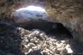
The staircase leads down into a collapsed area that splits the lava tube. This skylight cradles a miniature rainforest where ferns and philodendron drape down the sides of the cave. To the left and right of the bottom of the stairs are two openings into the lava tube.
The staircase down into the collapsed entrance to the lava tube
North of the entrance for Kaumana Caves
Turning right at the bottom of the staircase leads to the larger of the two entrances. Walk down stone steps to a tall opening in the tube. Sunlight illuminates the front of a sizable room in the lava tube. While much is visible at first, you will quickly need to rely on flashlights to see inside the cave.
Exploring Kaumana Caves
Step onto the floor of the lava tube, which has the ropy and smooth characteristics of pahoehole lava. Pahoehoe is the smoother type of lava that looks like hardened batter (instead of jagged rocks of an ‘a‘a flow). Do watch your step though, as the floor contains jagged breakdown areas where lava rock has collapsed.
Move toward the back of the large room in the lava tube. Climb up a breakdown and check out the roots hanging from the ceiling of the cave. Examine the different colors of growth on the dark walls of the cave. After about 100 yards, the room shrinks to a narrow passage below a cave breakdown. Beyond this point, the cave opens up again before another breakdown that makes passage difficult.
Explore what you wish, or simply enjoy the first large long room on the north side of the Kaumana Caves lava tube. Make your way back up and out into the open air by the staircase.
The large room by the northern cave entrance
South of the entrance for Kaumana Caves
Turning left at the bottom of the stairs leads to the smaller of the two entrances. This cave opening is about a quarter the size of the other one and more difficult to access. Make your way down a makeshift staircase over chunky boulders from the cave breakdown that exposed the lava tube.
Once you get inside the cave and are standing firmly on the cave floor, notice a new obstacle ahead. A shelf of lava rock sits right across the middle of the cave, dividing it off into upper and lower areas. At first, it might look like there’s no where to go. Duck under the shelf and scooch your way to the other side. Beyond the barrier, you’ll be able to stand easily again inside a long, relatively narrow lava tube.
A shelf blocking the rest of the lava tube
After the early challenges, the walking becomes unobstructed. It is possible to travel for quite a long distance up the lava tube (or at least until the invisible boundary where the cave leaves county land for private property). As you travel into the cave, examine all the different shapes in the lava where it has cooled on the ceiling, walls, and floor. Molten lava does some fascinating things when it cools!
Bat-like features in the ceiling of the lava tube
Once you have gone as far back into the cave as you’d like, or spent as much time in the dark as you care to, make your way back out of the cave and take the staircase back to the surface near the parking area.
How are lava tubes created?
Lava tubes channel eruptions of fluid basaltic lava (pahoehoe). When Mauna Loa erupted in 1881, the surface of the lava flow cooled first, while the lava below the crust remained molten. Like plumbing for the eruption, this tube formed below the surface and channeled lava downhill. The hardened walls of the tube insulate the lava so that it did not cool until it spilled out of the end of the tube. When the eruption stopped, and new lava was no longer entering the tube, the molten lava already in the tube continued its downhill flow, leaving behind an empty cavity.
(adsbygoogle = window.adsbygoogle || []).push({});
As the lava tube hollowed out, the 1881 lava flow halted about a mile from downtown Hilo (about 37 miles from the summit of Mauna Loa). Princess Ruth Keʻelikōlani of the Kamehameha dynasty is credited with saving Hilo from destruction. She camped in front of the lava flow and prayed to the great Hawaiian deity Pele, the creator of the Hawaiian Islands and the goddess of fire and volcanoes.
In subsequent years, an area above part of the lava tube collapsed and the caves were revealed. Even when the roof of a lava tube doesn’t completely collapse to create a skylight, sections of the roof can fall, called breakdowns, which leave jagged rocks on the floor of the cave to traverse.
Looking up the lava tube in Kaumana Caves
What to bring to Kaumana Caves Lava Tube
Sturdy footwear is recommended. Lava tubes are very dark. Bring multiple bright lights (flashlights) per person if possible. Unlike lava caves that you might encounter in the Pacific Northwest, the Kaumana Caves are warm and humid like the surface above. Pack one extra layer for safety. Kaumana Caves is managed by the Department of Parks and Recreation for the County of Hawaii. No fee is required to park at the trailhead and enter the cave, so get out and enjoy!
To get to the trailhead: Take Hawaii 19 (Hawaii Belt Road) to the center of Hilo and head inland on Waiamuenue Avenue. Drive 1 mile and bear left through a split onto Kaumana Drive (don’t turn right toward Rainbow Falls). Take Kaumana Drive for 3 miles. On the outside of a major bend to the right, turn left into the parking area for the caves. A sign by the entrance of Kaumana Caves is visible on the right just before the parking area. Park and walk across the road, being cautious to avoid the traffic.
Trailhead address: Kaumana Drive, Hilo, HI 96720 Trailhead coordinates: 19.6866, -155.1309 (19° 41′ 11.8″N 155° 07′ 51.2″W)
Use this map to view the trail and get directions:
(adsbygoogle = window.adsbygoogle || []).push({});
View Hilo trails in a larger map Or view a regional map of surrounding Hawaii trails.
Photos
Nearby Trails
Similar Trails
More Info
Photos


These photos were taken in October of 2018. Click to enlarge.
Nearby Trails

Rainbow Falls This 0.2-mile hike around Rainbow Falls Lookout explores a viewpoint facing a lovely waterfall and also ventures up to the top of the falls.

‘Akaka Falls This short loop slips through a tropical valley to bold views of a 442-foot single-drop waterfall.

Waipi‘o Beach & Muliwai Trail Overlook This 4.88-mile hike plunges into fantastically-wild Waipi‘o Valley, crosses a remote black sand beach (framed by cliffs and waterfalls), and climbs to a stellar view overlooking the ocean, beach, and valley.

Kalahuipua‘a Trail and Fishponds Loop This action-packed 1.7-mile hike explores a lava field with a lava tube shelter and impressive fishponds along a gorgeous coastline.

Malama Trail This 0.2 to 1.2-mile hike visits rare rock carvings in Puakō Petroglyph Archeological District on the west coast of the Big Island of Hawai’i.

Kiholo Bay & Wainanali‘i Lagoon This 2-mile coastal hike in Kiholo State Park Reserve has non-stop ocean views, crossing tide pools and beaches on the way to a turquoise lagoon.
Similar Trails

Ape Cave in Mount Saint Helens National Volcanic Monument (Washington) This adventurous underground hike travels through one of the longest lava tubes in the world.

Trail of Two Forests in Mount Saint Helens National Volcanic Monument (Washington) This short nature trail tours a landscaped that was transformed by a molten lava flow. For extra fun, crawl through a 50-foot long lava tube beneath the trail.

Guler Ice Cave in Gifford Pinchot National Forest (Washington) This short hike goes underground to explore an old lava tube with frozen stalactites and stalagmites, plus other interesting cave features.

Lava River Cave in Newberry National Volcanic Monument (Oregon) This underground hike explores a lava tube south of Bend that is filled with fascinating volcanic features.

Lava Tube in Mojave National Preserve (California) This short 0.6-mile hike drops below the desert surface into an old lava tube with a spectacular skylight.
Caves Trail in Crates of the Moon National Monument (Idaho) This 1.6 mile travels above and below the surface, exploring lava tubes in the Great Rift Lava Flow.

Kalahuipua’a Trail and Fishponds Loop (Hawaii) This action-packed 1.7-mile hike explores a lava field with a lava tube shelter and impressive fishponds along a gorgeous coastline.
More Info
Kaumana Caves in Hawaii Trails: Walks, Strolls, and Treks on the Big Island by Kathey Morey
Kaumana Caves on hawaii-guide.com
Kaumana Caves on atlasobscura.com
Kaumana Caves on explore-the-big-island.com
Kaumana Caves on inspiredimperfection.com
Kaumana Caves on outdoorproject.com
Kaumana Caves on bigislandhikes.com
from hikespeak.com https://www.hikespeak.com/trails/kaumana-caves-lava-tube-hilo-hawaii/
0 notes
Text
Rainbow Falls in Wailuku River State Park
A mile and a half from downtown Hilo, the biggest city on the Big Island of Hawaii, Rainbow Falls pours over a basalt ledge in Hawaii’s longest river. The 80-foot tall waterfall takes a broad single-drop plunge. Visitors can see Rainbow Falls (and hopefully a morning rainbow) from Rainbow Falls Lookout in Wailuku River State Park, where 0.2 miles of lets-be-generous-and-call-it-hiking leads to one viewpoint facing the waterfall and another perch alongside the top of Rainbow Falls. With minimal effort and plenty of beauty as reward, Rainbow Falls belongs on every Hilo trip itinerary.
(adsbygoogle = window.adsbygoogle || []).push({});
Pull up to the parking area for Rainbow Falls Lookout, nestled within the city of Hilo, just 1.5 miles west of it’s coastal downtown. Straight ahead of the parking area is a 70-yard long viewing area facing Rainbow Falls. A paved ramp and walkway makes this area of the park wheelchair accessible. On your left as you face the waterfall, spot another trail packed with rock slab steps that rise to the brink of Rainbow Falls.
Rainbow Falls
Rainbow Falls
The easiest and best way to see Rainbow Falls is from the viewpoint that is level with the parking area. Walk out and enjoy head-on views of the waterfall. A curtain of white pours over a shelf of black basalt. Sunny mornings are the recommend moments to observe the waterfall’s renown rainbows. A park info panel offers this description of the waterfall:
The waters of the Wailuku River drop 80 feet (24 meters) to create Waiānuenue or Rainbow Falls. Plunging in front of a natural lava cave created by the powerful splash back, the water falls into the large pool below. The width of the waterfall increases during periods of heavy rainfall.
According to Hawaiian mythology, the cave in the overhang behind the waterfall was home to Hina, the mother of demigod Maui. A giant lizard named Kanu tried to drown Hina while she was in the cave, resulting in a epic battle with Maui in the Wailuku River.
Rainbow Falls might be a shorter beauty, but the volume of the river gives the waterfall heft and significance. Once you have taken in this perspective of Rainbow Falls, backtrack toward the parking area to venture up the next trail, which is steeper and slightly longer.
Steps up to the viewpoint at the brink of Rainbow Falls
Top of Rainbow Falls
Leave the parking area again and begin up rock steps that ascend the slope south of Rainbow Falls. Metal railings along the staircase assist with the climb. After around thirty steps, the trail levels out atop the basalt ledge beside Rainbow Falls.
Walk up to the railing at an overlook by the brink of Rainbow Falls. Watch the waterfall pour over the edge of the jagged basalt ledge. Look down on a pool that extends to the right, below the viewing area where you just stood. Wailuku River makes its way past the pool to the left on its course to the coast. The exposed banks of the river signal just how much higher the water level can get.
Wailuku River below Rainbow Falls
The most interesting thing about the top of Rainbow Falls might not be the waterfall itself (you get a better view from the lower viewpoint). Instead, it is the wild depressions and pools in the riverbed surrounding the top of the waterfall that draw your attention. The basalt surface is full of strange pockets and other shapes.
Pools in the rocks beside Rainbow Falls
(adsbygoogle = window.adsbygoogle || []).push({});
The trail end at the top of Rainbow Falls. Footpaths continue upriver through a grove of banyan trees, but this area appears to be off limits. Flash flooding and rapid rises in the river have proven deadly, so exploring beyond the trail has risks.
Once you’ve seen the top of Rainbow Falls and gazed up and down the river, follow the step-packed trail down to the parking area to complete this 0.2-mile round trip hike with 40 feet of elevation change. Dogs and bikes are not allowed on this outing. Parking at Rainbow Falls Lookout in Wailuku River State Park is free, so get out and enjoy!
Boiling Pots Lookout
A short distance up the river from Rainbow Falls Lookout, find Boiling Pots Lookout positioned over an area of the river made up of pools resembling boiling pots. Some people like to use these pools as swimming holes during the right conditions. Wailuku River is prone to dangerous flash floods (the translation for Wailuku is “waters of destruction”). Observe all barriers and signs.
Want to see another waterfall? Check out nearby ‘Akaka Falls, which is 5.5 times taller than Rainbow Falls.
To get to Rainbow Falls Lookout: Take Hawaii 19 (Hawaii Belt Road) to the center of Hilo and head inland on Waiamuenue Avenue. Drive 1 mile and stay right through a split with Kaumana Drive to continue up Waianuenue Avenue, following signs for Rainbow Falls. Drive another quarter mile and turn right onto Rainbow Drive. The parking area for the lookout is on the right after another quarter mile.
To get to Boiling Pots Lookout, continue up Rainbow Drive and reconnect with Waianuenue Avenue. Turn right and drive 1.3 miles farther up Waianuenue Avenue. Turn right onto Pe’epe’e Falls Road. Go one block and turn left into the parking area for Boiling Pots Lookout.
Trailhead address: Rainbow Falls Lookout, Rainbow Drive, Hilo, HI 96720 Trailhead coordinates: 19.71885, -155.1085 (19° 43′ 07.9″N 155° 06′ 30.6″W)
from hikespeak.com https://www.hikespeak.com/trails/rainbow-falls-wailuku-river-state-park-hilo-hawaii/
0 notes
Text
‘Akaka Falls Loop Trail in ‘Akaka Falls State Park
‘Akaka Falls is stunner – considered one of the most beautiful waterfalls in Hawaii – with a 442-foot single-drop into a tropical valley. This great waterfall is paired with a great viewpoint. A paved 0.55-mile long loop trail leads to a lookout in front of ‘Akaka Falls, while also providing a glimpse of 300-foot tall Kahuna Falls and several small cascades. ‘Akaka Falls is the tallest waterfall on Kolekole Stream, which flows down the north side of Mauna Kea through the rainiest area of the Big Island. Expect the waterfalls to be gushing and the vegetation to be vibrant.
(adsbygoogle = window.adsbygoogle || []).push({});
Start from a road’s end trailhead parking area in ‘Akaka Falls State Park, which has info panels and partial views of the waterfall. To really see ‘Akaka Falls, begin down the paved trail leaving the parking area.
Cross a slope of tropical plants and comes to a T-junction after twenty-five yards. The shortest route to ‘Akaka Falls is to the left and you might visit the waterfall on a 1/3 of a mile out and back hike. But why not hike the full loop and see more of the forest, take a look at Kahuna Falls, and collect additional views of ‘Akaka Falls? The loop trail is a little over half a mile long with 115 feet of elevation change.
Turn right to follow the recommended direction for the ‘Akaka Falls Loop Trail (which is counter-clockwise). The trail descends along the side of a lush ravine. Several flights of steps are built into the paved trail. Watch your step. Rain falls frequently in this area, so the trail surface can get slippery. Ferns and impatiens cling to the side of the valley to your right, while a stream flows down the ravine to your left. The trees all around the trail are covered in various epiphytes (plants that grow on other plants), so the surroundings are lush and jungle-like.
‘Akaka Falls Loop Trail
Descend to a footbridge over the small stream, which is flanked by tall stalks of bamboo. A sprawling tree above the left side of the gulch is particularly impressive. Leaving the stream, the trail passes through the bamboo to a junction. A sharp turn to the left leads to the rest of the loop. Straight ahead, it is just a few more steps to Kahuna Falls Lookout.
Kahuna Falls Lookout
Kahuna Falls Lookout
Peer out across the verdant valley carved by Kolekole Stream (downstream of ‘Akaka Falls). On the far side of the valley, look for a streak of white tumbling down the tree-covered slope. Kahuna Falls pours into the valley from a side stream. This 300-foot tall waterfall is obscured by trees, unlike ‘Akaka Falls, and harder to appreciate.
Kahuna Falls
As you pause to observe the waterfall, consider how this landscape was formed, as chronicled by a park info panel:
Starting over 250,000 years ago, a spectacular volcanic eruption created Mauna Kea as many layers of lava flowed from the summit to the ocean. At the end of the eruption, a mantle of volcanic ash was laid on top of the basalt lava. Today, Mauna Kea is dormant and the summit is 13,796 feet above sea level. Rising over 30,000 feet from the ocean floor, it is the tallest mountain in the world. As the rain falls on the upper slopes of Mauna Kea, the water collects and runs down the slopes to the Hāmākua Coast. Streams have cut through the ash and basalt to create deep, narrow gulches. Waterfalls form when the denser basalt does not erode as easily and water must take a steep drop.
Leave Kahuna Falls Lookout, backtrack to the junction, and continue with the loop. The paved trail climbs for a stretch, rising along a ridge between the main valley and the gulch you descended to start the loop. The vegetation remains abundant and impressive. After a short ascent, the trail levels out and turns downhill. As you begin down more stairs, the growing perspective of ‘Akaka Falls will usher you forward.
‘Akaka Falls Loop Trail
‘Akaka Falls Lookout
Descend to ‘Akaka Falls Lookout, which has a shelter – should you need to get out of the sun or rain. Step up to the railing and look out at ‘Akaka Falls (the cliffs in front of the overlook are quite steep, so definitely stay behind the barriers).
The 442-foot tall waterfall takes a single-drop plunge into the round pool below. ‘Akaka Falls has a straight drop beside cliffs of dark volcanic rock that are draped in green moss and ferns. Kolekole Stream begins on the upper slopes of Mauna Kea and carries lots of water over ‘Akaka Falls.The 40-story waterfall is an impressive sight! To the left of ‘Akaka Falls, you may spot a thin ribbon-like waterfall that pour down the cliffs during wet conditions, completing the sensational scene.
‘Akaka Falls
Something fishy about ‘Akaka Falls
Just past the shelter, find a couple info panels that describe how one incredible fish actually climbs up ‘Akaka Falls to swim in the stream above. To make their way up the swift stream and climb the wall of the waterfall, a goby fish called the ‘o‘opu ‘alamo‘o uses more than just powerful fins. The fish rely on suction disks on their undersides (ventral sides) to combat currents and climb steep, slick surfaces. The panel explains:
An ‘o‘opu begins as an egg laid in the upper reaches of the stream, often between rocks in the streambed. Once the egg hatches, the embryo drifts downstream with the current to the open ocean. The larvae remains in the ocean for up to 6 months. When the ‘o‘opu receives the freshwater signals from the stream, it is time to begin the swim back upstream.
The ‘o‘opu ‘alamo‘o swim two and a half miles up Kolekole Stream and then the five-inch long fish climb over four hundred feet up the slick cliffs against the flow of ‘Akaka Falls to reach the stream above where they can live out adulthood. What a journey!
The name ‘o‘opu ‘alamo‘o comes from the Hilo area and refers to the lizard-like (mo‘o) shape of the head. The scientific name for ‘o‘opu ‘alamo‘o is Lentipes concolor. This name recognizes the ability of the male to change colors during courtshop and periods of aggression.
Female ‘o‘opu are tan or olive in color, while males can turn black and orange when they need to impress. In addition to this fish, a shrimp called the ‘ōpaekala‘ole is also able to climb the waterfall. These amphidromous shrimp are also born in Kolekole Stream and swept away to the ocean to grow as larvae before returning to the stream.
An ‘o‘opu ‘alamo‘o goby fish (on the right) moving up a stream near ‘Akaka Falls
(adsbygoogle = window.adsbygoogle || []).push({});
‘Akaka Falls Loop Trail
Spend ample time admiring ‘Akaka Falls. Then leave the lookout shelter and continue with the loop trail. If stepping away from the beautiful waterfall gets you down, fret not; the trail does its best to keep your spirits high by passing several smaller cascades. Study these streams and you may spot an ‘o‘opu fish ascending one of the branches off Kolekole Stream (apparently trying to avoid the big waterfalls).
The tropical vegetation along the trail is lush and flowering. The green leaves of philodendron are accented by impressive red blooms of lobster claw heliconia. The red-tipped leaves of ti plants thrive along the trail too. Admire the diverse plant life, which is almost completely non-native. As the din of the waterfall fades away, listen for singing birds. This area of the Big Island is home to several uniquely adapted Hawaiian birds like ‘i‘wi, ‘amakihi, ‘apapane, and ‘elepaio.
Cascades along ‘Akaka Falls Loop Trail
Cross a second creek, a tenth of a mile from ‘Akaka Falls and half a mile from the start. Admire cascades that are both upstream and downstream from the bridge. Across the bridge, the trail turns left and rises along a fern-covered slope. To your left is a new perspective down the gulch that you explored on the way to Kahuna Falls Lookout. Make your way up to the junction where the loop began. Bear right and walk back to the parking area.
The bridge at the end of ‘Akaka Falls Loop Trail
Although no hiking permit is needed for this short loop, ‘Akaka Falls State Park does charge an entrance fee, which is $5 per vehicle or $1 per person for those who arrive by bike or on foot. Hawaii residents may visit the park without charge. The fee can be paid an electronic kiosk or with the assistants of a park attendant. Bathrooms are located at the trailhead. Bikes and dogs are not allowed on this hike. The parking area in ‘Akaka Falls State Park is open from 8:30 a.m. to 6 p.m.
To get to the trailhead: From Hilo, Taka Hawaii 19 (Hawaii Belt Road) north for 11 miles. Following signs for Akaka Falls, turn left up Honomu Road (on the mauka side of the road). Drive 0.4 miles up to the town of Honomu. Turn left and then make the second right onto State Highway 220 (Akaka Falls Road). Drive another 3.3 miles to the trailhead parking area at road‘s end.
Coming from Waimea, travel 43.5 miles east on Hawaii 19 (Hawaii Belt Road) to the intersection with Honomu Road that leads up to Akaka Falls Road.
Trailhead address: Kiholo Bay Parking, Akaka Falls Road, Honomu, HI 96728 Trailhead coordinates: 19.854, -155.1523 (19° 51′ 14.4″N 155° 09′ 08.3″W)
from hikespeak.com https://www.hikespeak.com/trails/akaka-falls-hike-hawaii/
0 notes
Text
Waipio Lookout in Waipi‘o Valley
Waipi‘o Valley is a rugged, beautiful, and historic Hawaiian valley on the north side of the Big Island. The verdant valley has a mile long black sand beach framed by steep, thousand foot-tall cliffs. Get a good look at Waipi‘o Valley from a perch at the rim of the valley wall. Waipio Lookout has interesting info panels and impressive views. The lookout is also the launch point for a rewarding hike to Waipi‘o Beach and Muliwai Trail Overlook.
(adsbygoogle = window.adsbygoogle || []).push({});
Make your way to the end of Honokaa-Waipio Road on the Hāmākua Coast on the north side of the Big Island of Hawaii. Waipio Lookout (also called Waipi‘o Valley Lookout) has a small parking area off the right side of the road.
Straight off the end of Honokaa-Waipio Road, Waipio Valley Road descends toward the valley floor. This rugged, narrow, and super-steep road is for high-clearance four-wheel-drive Vehicles only. Don’t bypass the overlook for this intense drive!
From the parking area at the scenic end of Honokaa-Waipio Road, a paved path descends around 65 feet in elevation along a grassy slope. After a 125-yard walk, arrive a collection of info panels that accompany views across Waipi‘o Valley and Waipi‘o Beach. The blue water of Waipi‘o Bay is over 800 feet below.
Waipi‘o Beach in Waipi‘o Valley
Waipi‘o Beach stretches across the bottom of the valley, with a slightly curved arc of dark sand. While Waipi‘o Beach and the bottom of Waipi‘o Valley are easy to see, most of Waipi‘o Valley is out of view from the lookout. Gaze west across the valley toward rugged cliffs dropping into the Pacific Ocean. Around the north end of the cliffs, you may spot ephemeral Waipahoehoe Falls streaking down the shoreline bluffs.
Waipahoehoe Falls and the coastal cliffs west of Waipi‘o Valley
Waipi‘o Valley is known as the Valley of Kings for its regal chapter in Hawaiian history. Waipi‘o Valley was the chosen home of many Hawaiian kings. Nine rules in the Pili dynasty lived in Waipi‘o Valley, including Umi-a-Līloa, who united the Big Island under one ruler.
Waipi‘o Valley was also the mythological home of Hawaiian gods like Kanaloa and Kāne. The temple of Pākaʻalana was an important site in the valley. One of the panels describes the valley’s history:
The ancient chiefs of Waipi‘o Valley took care of the land, the people, and the gods. Only those who led a righteous lifestyle were allowed to ascend the sacred platform of the high chief of Līloa located in Waipi‘o. Līloa was a righteous ruler in the 1300s with multitudes of descendants. Historical and cultural sites are found throughout the valley, including countless burial sites. These sites are protected, so please do not disturb!
(adsbygoogle = window.adsbygoogle || []).push({});
In 1946, tidal waves changed the valley forever; 55-foot tall waves swept up the valley, destroying temples, both ancient and modern homes, and taro fields.
Read the panels and admire the views. If you’re inspired, consider hiking to Waipi‘o Beach and Muliwai Trail Overlook. Otherwise, simply walk back up the path to Honokaa-Waipio Road. Another path by the lookout ventures south over to Waipio Valley Road (which could be taken to hike down to Waipi‘o Beach). The short walk to Waipio Lookout is 0.15 miles round trip with 65 feet of elevation change. Pets are not allowed at Waipio Lookout. Parking beside Honokaa-Waipio Road is free and no permit is required to visit Waipio Lookout, so get out and enjoy!
Waipio Lookout
To get to Waipio Lookout: From Waimea, take Hawaii 19 east for 13.5 miles. Turn left on Plumeria Street and drive 0.6 miles down to the town of Honakaa. Turn left onto Mamane Street, which becomes Honokaa-Waipio Road (Hawaii 240). Drive 8 miles to Waipio Lookout at the end of the road.
From Hilo, take Hawaii 19 northwest for 39.5 miles. Turn right onto Honokaa-Waipio Road (Hawaii 240), following signs for Honokaa and Waipio. Drive another 9.5 miles to Waipio Lookout.
Lookout address: Waipio Lookout, Honokaa-Waipio Road, Kukuihaele, HI 96727 Lookout coordinates: 20.1177, -155.5836 (20° 07′ 03.7″N 155° 35′ 01″W)
Use the map below to view the overlook and get directions:
(adsbygoogle = window.adsbygoogle || []).push({});
View Waipio Valley in a larger map Or view Hawaii trails and campgrounds in a larger map
Photos
Nearby Trails
More Info
Photos


These photos were taken in October of 2018. Click to enlarge.
Nearby Trails

Waipi‘o Beach & Muliwai Trail Overlook This 4.88-mile hike plunges into fantastically-wild Waipi‘o Valley, crosses a remote black sand beach (framed by cliffs and waterfalls), and climbs to a stellar view overlooking the ocean, beach, and valley.

Kalahuipua‘a Trail and Fishponds Loop This action-packed 1.7-mile hike explores a lava field with a lava tube shelter and impressive fishponds along a gorgeous coastline.

Malama Trail This 0.2 to 1.2-mile hike visits rare rock carvings in Puakō Petroglyph Archeological District on the west coast of the Big Island of Hawai‘i.

Kiholo Bay & Wainanali‘i Lagoon This 2-mile coastal hike in Kiholo State Park Reserve has non-stop ocean views, crossing tide pools and beaches on the way to a turquoise lagoon.
More Info
Waipio Lookout on gohawaii.com
Waipio Lookout on gohikeit.com
Waipi’o Valley and Muliwai Trail on bigislandhikes.com
Waipi’o Valley on hawaii-guide.com
Waipi’o Valley on lovingthebigisland.wordpress.com
Waipi’o Valley on lovebigisland.com
Waipi’o Valley on wikipedia.org
from hikespeak.com https://www.hikespeak.com/attractions/waipio-lookout-waipio-valley-hawaii/
0 notes
Text
Waipi’o Beach & Muliwai Trail Overlook in Waipi’o Valley
Waipi’o Valley is known as the Valley of Kings for its regal chapter in Hawaiian history. You’re bound to feel high and mighty while looking across this remote valley and its pristine beach from a panoramic perch on Muliwai Trail. Waipi’o Valley has steep, thousand foot-tall cliffs, so entering the valley is no simple stroll. Cross Waipi’o Beach and visit Muliwai Trail Overlook on a 4.88-mile round trip hike that has climbs on each side of the valley that total 1,300 feet of elevation gain. Waipi’o Valley is a special place for an extra Hawaiian hike.
(adsbygoogle = window.adsbygoogle || []).push({});
Waipi’o is a deep valley on the Hāmākua Coast on the north side of the Big Island of Hawai’i. Muliwai Trail starts on the west side of Waipi’o Valley and travels 7.7 miles to Waimanu Valley, crossing several smaller valleys en route. Muliwai Trail is too long and arduous for a day hike, but you only need to hike 1/3 of a mile up the trail to Muliwai Trail Overlook for a worthwhile outing.
To get to Muliwai Trail Overlook, hikers need to descend into Waipi’o Valley and cross Waipi’o Beach to Muliwai Trailhead. The itinerary is as follows:
Start from Waipi’o Lookout, which has kingly valley views of its own
Plunge 850 feet down a rough 4X4 road to arrive at Waipi’o Beach (those with proper vehicles and access can drive all the way to a beach)
Enjoy a 3/4-mile walk across a lovely black sand beach, framed by tall cliffs and waterfalls that tumble into the ocean
Leave the unspoiled sand to make a short, but challenging climb up narrow switchbacks on the start of Muliwai Trail, also known as Waimanu Trail and Z-Trail, which maneuvers up the valley wall to a sweeping view over the ocean, across Waipi’o Beach, and up the verdant valley toward Hi’ilawe Falls, which plunging nearly 1,500 feet into Waipi’o Valley
To get started, make your way to the very end of Honokaa-Waipio Road where Waipio Lookout (Waipi’o Valley Lookout) has a small parking area off the right side of the road. Straight off the end of Honokaa-Waipio Road, Waipio Valley Road begins a determined descent from the rim of the valley down to its floor.
Waipio Lookout
Before getting underway, the first thing to do is to check out Waipio Lookout. A paved path from the parking area descends to a collection of info panels accompanying views across Waipi’o Valley and Waipi’o Beach.
Gaze east across the valley toward rugged cliffs dropping into the Pacific Ocean. Look closely at the imposing, verdant cliffs on the far side of the valley to spot Muliwai Trail zigzagging up the side. To the right of the trail, around the end of the ridge, you may spot ephemeral Waipahoehoe Falls streaking down the cliffs to the shoreline.
Waipio Lookout
The info panels explain that Waipi’o Valley was the chosen home of many Hawaiian kings. Nine rules in the Pili dynasty lived in Waipi’o Valley, including Umi-a-Līloa, who united the Big Island under one ruler. Waipi’o Valley was also the mythological home of Hawaiian gods like Kanaloa and Kāne. In 1946, tidal waves changed Waipi’o forever – picture 55-foot tall waves sweeping up the valley – destroying temples, both ancient and modern homes, and taro fields. Taro is the most important Hawaiian crop.
Leave Waipio Lookout and take the path to the south, which bridges a short distance to Waipio Valley Road. Reach the pavement and turn right down the Waipio Valley Road.
Waipio Valley Road
Waipio Valley Road is poorly paved, narrow, and extremely steep. The road drops 850 feet in 0.83 miles and is restricted to high-clearance 4-wheel drive vehicles. The road’s average grade is 25% and some stretches pitch down to a 40% grade. Driving into Waipi’o Valley is not recommended for those who aren’t familiar with the road or don’t have appropriate vehicles. Many rental car agreements prohibit traveling down Waipi’o Valley Road. As the road is only meant to serve valley residents and guest, hikers should plan to set out from the top of Waipi’o Valley Road and hike down.
Waipio Valley Road is quite a roadway. Cars have the right-of-way, so hikers need to stick to the side of the road away from vehicles. Descend swiftly to a horseshoe bend to the right. A fork of the road parts to the left from the outside of the bend. Stay to the right to continue down Waipio Valley Road. Coming out of the bend, the views start to open up across Waipi’o Valley.
Waipio Valley Road
Continue down the no no-nonsense road, angling down the side of the valley. The unrelenting road uncovers nice valley views. Keep in mind that you will have to hike back up this road at the end of the day, so be sure to save some energy, water, and snacks. Don’t overcommit yourself.
Waipio Valley Road is one extremely steep road! Keep traveling down into Waipi’o Valley. As you descend, Wailoa Stream grows more prominent, traveling across the valley floor toward the beach. During rainy months, a half dozen ephemeral waterfalls stream down creases on the west side of the valley.
Looking down Waipi’o Valley toward the coast
After 0.9 miles of hiking (including the initial exploration off Waipio Valley Road to Waipio Lookout), come to the bottom of the valley wall where the road hits an intersection. To the left, a road heads into more private areas up Waipi’o Valley. Resist the urge to get closer to Hi’ilawe Falls and treat this road as through it is off limits. Turn right to head toward the coast. It should please you to discover that the road ahead is nice and level. Indeed, there is little elevation change over the next 1.25 miles on the road and beach.
After turning right at the T-intersection at the bottom of Waipio Valley Road, stay to the right on the rutted dirt road as it passes a driveway on the left. A sign along the road reads, “road closed due to unsafe conditions – property owners will not be held responsible for any injuries and/or damages that may occur.”
Make your way up the road past wetlands along Wailoa Stream. The trail passes through forest at the base of the valley wall. Although level, the dirt road has many mud puddles for you to dance around (or through). Feral horses live throughout Waipi’o Valley. You are likely to cross a few horses along the road or at the beach. The horses seem to either ignore humans or act friendly in search of food.
A tenth of a mile before the end of the road, stay to the right past another drive that branches off to the left. The more-traveled road is obvious. Soon after that, come to the edge of the forest behind Waipi’o Beach. The road basically ends here (1.4 miles from the start of your adventure), but jeep trails extend to the right and left toward parking spaces behind the beach.
Waipi’o Beach
Waipi’o Beach
Waipi’o Beach is a north-facing beach that is nearly a mile long. The road ends by the east side of the beach. Muliwai Trail starts from the west end of Waipi’o Beach, so fortunately for you, the next leg of the trek is to walk 3/4 of a mile across the beach.
The east end of Waipi’o Beach
If you turned right at the end of the road, instead of heading west, you’d find that the beach continues for another 0.2 miles, becoming very rocky as it meets cliffs at the east edge of the beach. For another Waipi’o adventure, visitors can trek half a mile along the rocky coastline to the spot where Lakuahine Falls tumbles down the cliffs to the ocean. During high tide or rough surf, do not attempt to cross the boulders along the way to Lakuahine Falls as it can be too dangerous.
To get a perspective of Lakuahine Falls, it is actually easier to head west along the beach, away from the waterfall, allowing it to peak out from behind the cliffs and come into view.
Lakuahine Falls
Bear left at the end of the road and walk either across the beach or on paths through the trees just behind the sand. Portable toilets (of unreliable cleanliness) are located in the forest near the end of the road. Waipi’o Beach is quite a place, with almost a mile of welcoming black sand stretched out between towering cliffs. The coastline is undeveloped and gorgeous. The ocean may not be an inviting place to swim, however. Particularly when the surf is rough, the rip current can be quite dangerous. Do not swim or surf without experience in these conditions.
Walk west along Waipi’o Beach for 300 yards to an interruption in the sand. Wailoa Stream flows across the beach and into the ocean. No bridge crosses the stream, so you will need to wade across to reach the rest of the beach. Depending on the levels of the stream and the tide (and also your height), you’ll need to wade in up to your thigh or your waist to cross Wailoa Stream. The crossing can be difficult after major rainstorms and during high surf, so proceed only when safe.
Wailoa Stream crosses Waipi’o Beach
Wear water shoes to cross Wailoa Stream, or just go barefoot or in flip-flops. The water in Waipi’o Valley is known to contain leptospirosis, a sickening bacteria, so do not drink any of the water or make contact with the stream with open cuts.
While you might share the east side of Waipi’o Beach with a few parties of people, the rest of the beach should feel more secluded. The creek crossing provides enough of a barrier that you could have the rest of Waipi’o Beach mostly to yourself.
From the far side of Wailoa Stream, you have a couple ways to get to Muliwai Trail:
Route 1) If beaches aren’t really your thing, or if you prefer hiking on firmer ground (because you’re wearing a heavy pack, for example), find a path entering the woods on the left. Connect to a jeep trail that heads west through ironwoods, firs, and fern trees in the forest just behind the beach. The trail has gently rolling terrain and passes through lots of vegetation. The partially shaded trail runs parallel to the beach. When the beach ends, the trail turns inland (left) along the side of the valley around Muliwai Pond, coming to a marked junction at the bottom of Muliwai Trail.
The jeep trail behind Waipi’o Beach
Route 2) The more obvious and more enjoyable route is to simply walk up the beach until you can’t go any farther. Waipi’o Beach is fun to explore. Sink your toes into the black sand. Look out across the ocean, which fills the horizon. Over your shoulder, Lakuahine Falls pours down the cliffs on the east side of Waipi’o Bay. Straight ahead, the tall cliffs at the end of the beach look imposing, but are not inaccessible – because of the faint line of Muliwai Trail that zigzags up the valley wall. You may notice hikers standing at the end of a switchback straight above the beach. That is the overlook destination for this hike. Out around the west side of the cliffs, the coastline has a magical untouched quality. When the water is flowing, the white ribbon of Waipahoehoe Falls courses off the cliffs toward the coast.
Waipahoehoe Falls on the cliffs west of Waipi’o Beach
Large driftwood tree trunks are strewn across the back of the beach. Some act as nice benches, should you wish to take a break. In the fall, ripe guavas fall from the trees in Waipi’o Valley and get carried to the ocean by Wailoa Stream. The fruit washes up on the beach like little yellow balls of driftwood.
Instead of walking straight into the cliffs at the west end of the beach, bear left and head toward the trees. Meet the trail that runs behind the beach and follow the trail into the forest toward some cabins. Before the beach is even out of sight, you’ll come to a marked junction at the bottom of Muliwai Trail.
The west end of Waipi’o Beach
Muliwai Trail (a.k.a. Waimanu Trail or Z-Trail)
From Waipi’o beach, it is a short walk inland along the west side of Waipi’o Valley to the junction with Muliwai Trail. As of 2018, the signs for the trail read Waimanu Trail, which makes sense because the trail leads to Waimanu Valley, but the trail is officially known as Muliwai Trail. To complicate the naming game, the stretch of the trail up the wall of Waipi’o Valley is also called the Z-Trail because of its dramatic switchbacks, visible from a distance.
Turn right onto Muliwai Trail and start the climb. Pass a sign at the boundary of the Muliwai Section of Kohala Forest Reserve. Trees hang over the trail, so much of the ascent is shaded. The steepness of the trail is made tougher by the valley’s heat and humidity, so it can feel refreshing to catch breezes once you rise above the trees (the bold views are invigorating too).
After turns to the left, right, and left (three switchbacks), the trail leaves the forest for shorter brush and grasses that sprout from the sheer valley wall. After 0.2 miles on Muliwai Trail, things open up for a grand perspective over Waipi’o Valley that will stop your in your tracks.
Muliwai Trail rises out of Waipi’o Valley
If you liked the views from Waipio Lookout, you’ll love what Muliwai Trail has to offer – basically the opposite perspective across Waipi’o Valley. Muliwai Trail boasts a significantly broader vantage up the valley. Looks south over wetlands and fields that transition into a tropical rainforest wedged between steep green walls. On the west side of the valley below the trail, kidney-shaped Muliwai Pond offers a glistening reflection of the sky.
Looking across Muliwai Pond toward Hi’ilawe Falls
Along the east wall of Waipi’o Valley, Hi’ilawe Falls drops approximately 1,450 feet, including a 1,200-foot single fall from the valley wall. The beautiful waterfall is on private land and not accessible by trail, so this distant view is one of the best ways to see Hi’ilawe Falls. The bottom of Hi’ilawe Falls is shielded from view by a slope on the valley wall.
Hi’ilawe Falls
The vistas expand over the next eighth of a mile. The trail is steep, rocky, and narrow. Any time you need to catch your breath, just pause and enjoy the sweeping surroundings. The drop-offs on the right side of the trail are precipitous, so watch your step.
Muliwai Trail Overlook
After a third of a mile of climbing, Muliwai Trail comes to another sharp switchback (living up to it’s Z-Trail nickname). Off the right side of the trail, find an obvious, but unmarked, vista point. Step out and take in some spectacular sights.
Waipi’o Beach is below, stretching east and curving gently to the left. Look farther up the coastline to see Lakuahine Falls cascading down the cliffs toward the ocean. Waipi’o Bay is laid out below you, cradling gorgeous blue water.
To the right, look over ponds and streams surrounded by the greenery of Waipi’o Valley. Hi’ilawe Falls is in view as well (which is why this spot can also be called Hi’ilawe Falls Overlook instead of Muliwai Trail Overlook). This lookout offers a lot to look at!
Waipi’o Bay below Muliwai Trail Overlook
(adsbygoogle = window.adsbygoogle || []).push({});
Are you the type of person who visits a spectacular tropical valley and wonders what the next valley over looks like? The rest of Muliwai Trail may be for you! After more switchbacks on the side of Waipi’o Valley, the trail crosses a series of ridges and gulches before dropping into Waimanu Valley, which looks a lot like Waipi’o Valley but is even less developed and has a beach-adjacent campground for backpackers.
Muliwai Trail is 7.7 miles long and super tough. Unless you’re making this hike into an overnight (permit required), the early lookout is a good place to turn around. You might chose to climb another 800 feet up the next Z in Muliwai Trail to reach the rim of Waipi’o Valley and even bigger views. However, be sure to dose your efforts, because after coming down Muliwai Trail and crossing Waipi’o Beach, a final workout awaits in the 850-foot ascent on Waipio Valley Road.
The hike back
After enjoying all the views, turn around and head down Muliwai Trail. Cross the valley by either walking back across Waipi’o Beach or taking the trail through the trees behind the beach. Wade through Wailoa Stream and cool off your lower half in the rushing water. You’ll probably want to linger on Waipi’o Beach for a while before leaving.
Trek back up the dirt road along the east side of the valley for half a mile to the intersection below the climb. Turn left and ascend 850 feet in the final, grueling 0.83 miles up to Honokaa-Waipio Road beside Waipio Lookout.
Hiking back from Waipi’o Beach
Waipi’o Valley is beautiful and historic. Be respectful of the valley as you hike. Garbage collection is not provided, so pack out anything that you carry in. Pets are not allowed at Waipio Lookout, but dogs do seem to be allowed at Waipi’o Beach. Bikes can be used on the roadways (but would you want to). No permit is needed to enter Waipi’o Valley and day hike on Muliwai Trail. Permits are required for overnight stays at the campground in Waimanu Valley. Camping is not allowed at Waipi’o Beach. Parking at the trailhead is free but limited (observe all street signs).
The turn-by-turn directions for this hike are:
Take the path down to Waipio Lookout (0 miles)
Enjoy the lookout’s views and continue down Waipio Valley Road (0.07 miles)
At the intersection at the bottom of the steep road, turn right to head toward the coast (0.9 miles)
Stay to the right past two side roads and follow the level road to Waipi’o Beach (1.4 miles)
Turn left and walk east across Waipi’o Beach to a crossing of Wailoa Stream (1.6 miles)
Proceed to the end of the beach and head inland (2.1 miles)
Find the junction with Muliwai Trail and turn right up the trail (2.15 miles)
Reach a panoramic perch at a switchback on Muliwai Trail (Z-Trail) (2.47 miles)
Hike back down to the bottom of Muliwai Trail (2.8 miles)
Take the trail back through the forest behind Waipi’o Beach or walk across the beach again to the Waipio Stream crossing (3.35 miles)
Return to the beach parking area and turn right to walk back along the road (3.55 miles)
At the intersection, turn left up Waipio Valley Road (4.05 miles)
Ascend out of the valley and return to Honokaa-Waipio Road near Waipio Lookout (4.88 miles)
To get to the trailhead: From Waimea, take Hawaii 19 east for 13.5 miles. Turn left on Plumeria Street and drive 0.6 miles down to the town of Honakaa. Turn left onto Mamane Street, which becomes Honokaa-Waipio Road (Hawaii 240). Drive 8 miles to Waipio Lookout at the end of the road.
From Hilo, take Hawaii 19 northwest for 39.5 miles. Turn right onto Honokaa-Waipio Road (Hawaii 240), following signs for Honokaa and Waipio. Drive another 9.5 miles to Waipio Lookout.
Trailhead address: Waipio Lookout, Honokaa-Waipio Road, Kukuihaele, HI 96727 Trailhead coordinates: 20.1177, -155.5836 (20° 07′ 03.7″N 155° 35′ 01″W)
from hikespeak.com https://www.hikespeak.com/trails/waipio-valley-beach-hike-muliwai-trail-hawaii/
0 notes
Text
Kiholo Bay & Wainanali’i Lagoon in Kiholo State Park Reserve
While much of Hawaii’s coastline is understandably built up with vacation destination resorts, some areas have a wilder feel, like Kīholo Bay. Driftwood decorates the rugged coastline, just 25 miles north of Kona, and green sea turtles ease through the bay’s cyan-colored shallows. The Hawaii State Parks website describes Kīholo State Park Reserve as:
A stark, lava-covered coastal park with small bays, sparsely vegetated coastline, historic lava flows, and wide open spaces.
Experience the park on a two-mile round trip hike across a rocky shore, passing coves and beaches that lead to the turquoise water of Wainanali’i Lagoon. This lovely locale has a unique history – built into fishponds by Hawaiians prior to a landscape-redefining 19th century lava flow. Additional hiking in the park includes a 1-mile round trip outing down the coast in the opposite direction to a black sand beach.
(adsbygoogle = window.adsbygoogle || []).push({});
Start from a parking area at the end of a 1-mile long dirt road that descends to the coast from Hawaii 19, the main route north of Kona. Off the circle at the end of the road, find a wide trail crossing pahoehoe lava rock that pushes through an airy forest of kiawe trees for thirty yards to arrive at the coast. Ahead, the volcanic surface stretches into the ocean like black fingers, forming tide pools with their touch.
Unless you’re heading to the black sand beach, half a mile to the left, bear right to make your way toward Wainanali’i Lagoon. A well trodden path passes through an archway in the trees. The route becomes less defined as you go. Because most of the trek to Wainanali’i Lagoon is not on an established trail, the hiking can be rough and slow-going. Budget extra time for your visit.
The hiking path along Kiholo Bay
After 1/8 of a mile on the coast, look on your right for rocks that mark the site of Keanalele (also known as Queen’s Bath), a lava tube cave just below the surface. Openings in the crust of pahoehoe lava reveal a pool of freshwater mixing with saltwater in a tunnel just underground. Have a look, but stay out; swimming in this pool or any cave in Kīholo State Park Reserve is not permitted.
Continue walking northeast along the coast. As you go, enjoy views north over Kīholo Bay toward the slopes of Kohala. Soon afterward, and a quarter mile from the start, curl around the back of a partially sheltered cove. This is an easy spot to snorkel, if you’re eager to take a break and cool off in the ocean.
Walk up the coast past more tide pools. Cross a trail on the right that heads inland and connects to a road (which could be used to make a less scenic loop back to the trailhead). Keep on moving up the coast, where signs of a defined route lead to a picnic table atop a gravely beach. Just behind this beach is a large yellow building wrapped by coconut trees, one of the private holdings within the reserve. The picnic table is 0.4 miles from the trailhead and makes a decent early turnaround point for those who tire of trudging up the rocky shoreline.
Hiking toward a picnic table beside Kiholo Bay
Moving along, the path disappears, so forge your own route. Since your feet sink deeper into the rocks and sand than they would on a hard-packed trail, this two-mile hike may actually feel like double the distance because of the extra effort. If your legs get soar, simple stop and gaze out over the beautiful bay.
Driftwood along the shore
Shortly after the first property, spot a second retreat constructed in an impressive Balinese style. A bench here could be used to take a break. Aside from a few sandy stretches, the coast remains rocky as you continue north.
Arrive at a round point, 3/4 of mile from the start. The most recessed part of Kīholo Bay is to your right, hosting a short black beach. Across from the point, spot the small island and long peninsula framing Wainanali’i Lagoon. The blackened landscape of a not-so-old lava flow meets the far side of the bay.
Tide pools on the point facing Wainanali’i Lagoon
About 200 years ago, this view would have looked very different. Early in the 19th century, Kamehameha I, the first ruler of the kingdom of Hawaii, took advantage of the freshwater flowing into the bay and had an ambitious 6-foot tall, 20-foot wide seawall built to enclose a grand fishpond with a 2-mile circumference. A village stood next to this large-scale fish-farming operation. In 1859, a 300-day long eruption on Mauna Lau channeled molten lava to the coast, destroying the village and reshaping the fishponds and shoreline. Instead of being enclosed by a wall, water and marine life now flow freely around a small island and a long peninsula that partially enclose Wainanali’i Lagoon.
The beach by Wainanali’i Lagoon
Proceed past the point and walk around the back of the bay across the beach. Use a short bridge to cross a stream flowing into the bay that connects to privately-owned fishponds just inland. On the far side of the beach, make your way to the edge of Wainanali’i Lagoon. The turquoise pool is so inviting, you may be compelled to swim – or at least stand and watch the fish and sea turtles (honu).
Wainanali’i Lagoon (CC BY-SA 3.0)
The peninsula-shielded lagoon has calm clear water. The mixture of freshwater and ocean water in Wainanali’i Lagoon accounts for the vivid turquoise color, which is lighter than the rest of Kīholo Bay. Snorkelers are sure to see a splendid variety of tropical fish. The sea turtles have dibs on the lagoon, like the rest of Kīholo Bay, so give them plenty of space when you are on land and in the water. (It is illegal to approach the sea turtles.)
Wainanali’i Lagoon is about one mile from the trailhead. You could explore farther or swim for hours. Either way, return by the same route when it is time to leave.
A 360° view of Wainanali’i Lagoon on Google Maps
(adsbygoogle = window.adsbygoogle || []).push({});
Kīholo Bay Black Sand Beach
At the end of the path from the parking area to the coast, if you look to the left, you’ll spot a black sand beach. To reach it, just walk a half-mile down the shore. A pool behind the beach, called Waia’elepi can be observed but is not open for swimming.
Dogs are not allowed in Kīholo State Park Reserve. The coast is not suitable for bikes. The park is open from 7 a.m. to 7 p.m. from April through Labor Day and from 7 a.m. to 6 p.m. during the rest of the year. A camping area near the trailhead is open from weekends only. Sites are $12 per night (as of 2018) and may be reserved in advance on the state parks website. No permit is required to hike in Kīholo State Park Reserve and parking at the trailhead is free, so get out and enjoy!
The dirt road down to the trailhead from Highway 19 is somewhat rough, so high clearance vehicles are recommended.
To get to the trailhead: From Kona, travel north on Hawaii 19 (Queen Ka’ahumanu Highway). Pass Keahole Airport Road and go another 11 miles to a scenic overlook for Kiholo Bay on the left (makai side of the road). Take the turn lane to pull into the scenic overlook. Then pull back out onto Hawaii 19 and drive 0.4 miles southwest (in the opposite direction). Turn right down the first dirt road, which is unmarked. Drive 1 mile down this road to a trailhead parking area. Stay straight past roads on the right and left that come around 0.8 miles from Hawaii 19.
Coming from Waimea, it is a 25 miles southwest to the Kiholo Bay Scenic Overlook just before the turnoff for the road to the trailhead.
Trailhead address: Kiholo Bay Parking, Kīholo State Park Reserve, Queen Ka’ahumanu Highway, Kailua-Kona, HI 96740 Trailhead coordinates: 19.85125, -155.93188 (19° 51′ 04.5″N 155° 55′ 54.8″W)
from hikespeak.com https://www.hikespeak.com/trails/kiholo-bay-wainanalii-lagoon-hike-hawaii/
0 notes
Text
Kalahuipua’a Trail and Fishponds Loop in Kalahuipua’a Historic Park
A list of things for hikers to do on the Big Island of Hawai’i includes: walking across a lava field, exploring a cave, looking for petroglyphs, seeing fishponds created by early Hawaiians, and taking a time-out by tide pools in a beautiful bay. Check off everything on that list with one visit to Kalahuipua’a Historic Park and Fishpond Preserve. A loop around coastal Kalahuipua’a Fishponds connects to the end of Kalahuipua’a Trail to form a lollipop loop hike that is 1.7 miles long with just 30 feet of elevation change. This easy and varied hike has something new to experience around almost every turn.
(adsbygoogle = window.adsbygoogle || []).push({});
Kalahuipua’a Historic Park is located beside the Mauna Lani Resort on the west coast of the Big Island of Hawai’i, 25 miles north of Kona. From a trailhead parking area with bathrooms and picnic sites, set out on a paved trail that rises onto a pahoehoe lava field. (Pahoehoe is the smoother type of lava that looks like hardened batter.) Kalahuipua’a Trail crosses an ancient lava flow where minimal vegetation has yet to take hold.
Follow the trail’s weaving path past a few informative panels. The first panel is located in front of a collapsed area in the ground by the trail. The panel describes how lava tubes channel eruptions of pahoehoe lava:
The lava of this ancient flow cooled on the surface first while molten material continued its passage toward the sea under the surface crust. When the source of the lava was cut off, the still-molten lava continued its downhill flow, leaving behind these empty pipelines called lava tubes. You can see these where their roofs collapsed. Ancient Hawaiians found them to be good living quarters – cooler, drier, and less windy than surface shelters.
Kalahuipua’a Trail passes a collapsed area along the volcanic surface
Continue a little farther to another sign that describes woodworking tools made by early Hawaiians out of the volcanic rock. Hawaiians (including royalty) lived in this area for 800 years before the islands were discovered by westerners.
After this sign, the trail makes a big curve to the left and dips toward some short trees. As the trail curves back to the right, look for a path branching of to the left toward a cave below a shelf in the lava. The spot where the footpath leaves the paved trail is not marked with a sign, but you should be able to spot a couple panels in front of the cave to reassure you that this is the right spot to leave the pavement.
Hiking off the paved trail toward the lava tube shelter
At 0.2 miles from the start, stray off Kalahuipua’a Trail on the short path to the opening of a lava tube below the volcanic surface. Archeologists have scoured the cave and found evidence of early Hawaiians using the cave as a a shelter from AD 1500 to 1700. One panel explains:
This lava tube shelter was home to small groups of Hawaiians. They slept, worked, cooked, and ate here. The spacious flat floor, shade, protection from the wind and rain, and the cross-ventilation provided by other openings in the rear of the tube made it a very attractive location. A few mats on the floor and a small cooking fire would make this a comfortable shelter, even today.
The entrance of the lava tube shelter
Step into the lava tube and imagine how it might have appeared with these Hawaiians gathered inside. Stagger across the floor of the lava tube shelter, which is covered in a rubble of rocks that have fallen from the ceiling of the cave. Stand below an opening in the middle of the cave and look up toward the sky. Smaller openings leak light into different corners of the cave, making it easy to have a look around without a flashlight (although you might want to bring one).
Kalahuipua’a Lava Tube
When finished exploring the lava tube shelter, step out into the light. Take the path back to Kalahuipua’a Trail and turn left to continue along the paved trail.
Kalahuipua’a Trail crosses more of the lava field beside the Mauna Lani Resort. Just before the end of the trail, a rock-lined path ventures to the left. Amble a short distance up this path and see if you can find petroglyphs carved into the volcanic surface.
Many more petroglyphs can be seen at nearby Malama Trail in Puakō Petroglyph Archeological District
Continue on Kalahuipua’a Trail, which swiftly comes to an end, 0.35 miles from the start. Cross a road onto a wide paved trail leading to the first fishpond. Look left into Hope’ala Fishpond, a shallow emerald pool that is one of the seven fishponds preserved around the resort.
The first view into Hope’ala Fishpond
Walk 125 yards farther up the trail to a junction where the loop begins. Though you can head in either direction, the route described here suggests continuing straight (staying to the right).
Begin hiking the loop in a counter-clockwise direction. Overlook the encroaching resort buildings to the right and keep your gaze fixed across Lahuipua’a Fishpond, the largest pond in the preserve. A panel positioned beside the trail explains how early Hawaiians cultivated and fish-farmed these coastal pools.
Since men first found them, the fishponds at Kalahuipua’a have been a delightful oasis along this arid coast. These brackish ponds are fed and cleansed by fresh water springs seeping into them and the tidal action of the sea. By modifying them and by managing them wisely, the prehistoric Hawaiians were able to raise a variety of fish in these ponds. ‘Ama ‘ama (mullet) and awa (milkfish) were the most common raised fish, but other such as papio (jack), Kaku (barracuda) and puhi (eels) as well as ‘opae (shrimp) lived here also. These ponds are among the few anywhere that are still being managed in much the same way as they were in ancient times. They are still producing fish.
The fishpond of Lahuipua’a was once a shallow bay that early Hawaiians walled off and enclosed. The fish growing in the ponds eat algae off the bottoms. By keeping predators out, the fish are able to grow to a size where they can be harvested. (Recreational fishing in these fish farms is prohibited).
Lahuipua’a Fishpond
Walk along Lahuipua’a for a tenth of a mile to come to another junction. Kakaiwa Bay is right in front of you. The loop continues to the left, but why not see even more of the scenic coastline and fishponds? Bearing right, the trail becomes unpaved. Make a second immediate right to follow the dirt road past a reproduction of a petroglyph in front of the resort.
Enjoy sea breezes as you follow the dirt road north. On your right, spot fish swimming around Waipuhi Fishpond. Look at the hālau structure built along the cove to the left. The dirt road leads to a sand beach. Gaze out across Kakaiwa Bay and look north up the coast toward Kohala and the northwest tip of the Big Island of Hawai’i. Gazing out across Kakaiwa Bay, you may spot land across the sea. That’s the island of Maui, where the white domes of observatories shimmer atop Haleakalā.
Kakaiwa Bay
Resist the urge to venture farther up the coast to the north, (or go ahead and explore a little more of the shore in front of the resort). Bear left to curve south around the point. Walk back beside the hālau and admire the wooden frame and roof made of palm fronds. Follow a dirt path around the cove or hop across the rocky tide pools to spot tropical fish like black and yellow striped Moorish idols.
Come around the tide pools to a grassy lawn (at the end of the paved trail that you would have reached by turning left and the junction when you approached the coast). Walk across the lawn to a walkway on top of the wall built to separate Lahuipua’a Fishpond from the ocean. This stretch of the hike is lovely any way you look at it. A green palm-wrapped fishpond is to your left, while a turquoise, tide pool-wrapped bay is to your right.
Kakaiwa Bay
Along the short sea wall, pass a gate between the bay and the fishpond. The volcanic rock making up the sea wall has pores that actually filter some fresh ocean water into the ponds, but makaha gates were important for circulating water and controlling what fish could come in and out of the ponds, as a panel explains:
The prehistoric makaha was made of vertical wood poles lashed together and spaced to allow small fish from the ocean to enter. Larger fish from the pond could not get out. The makaha is the key to a productive fishpond. The makaha you see here was constructed recently but it works in the same way that a prehistoric makaha would have.
(adsbygoogle = window.adsbygoogle || []).push({});
Eels swim around the pool in front of the makaha. Pass a boat launch as the trail leaves the sea wall and becomes a wide gravel road. Approach a resort beach and bear left to stay on the road, keeping Lahuipua’a Fishpond on your left.
Come to a junction at the southwest corner of the loop, after a mile of hiking. Turn left, continuing to hug Lahuipua’a Fishpond and passing a blue sign for the “Historic Fishpond Preserve.” Follow the level and palm-lined trail along Lahuipua’a Fishpond, enjoying a nice perspective back toward the sea wall and the coast.
Lahuipua’a Fishpond
Next, you will hike past the smaller Kaaiopio Fishpond, which is stocked with mullet and milkfish. When you come to another junction (0.3 miles past the previous one), make the obvious left turn to continue on a route through the fishponds. The first pond on the hike, Hope’ala, reappears to your right as you make your way along the last piece of the loop.
Meet the junction where the circuit began and bear right. Cross the road to return to Kalahuipua’a Trail and take the paved path back to the trailhead. This lollipop loop hike in Kalahuipua’a Historic Park is 1.7 miles long with 30 feet of elevation change. Dogs and bikes are prohibited. No permit is required for this hike and parking at the trailhead is free, so get out and enjoy!
To get to the trailhead: From Kona, drive north on Hawaii 19 for 26 miles. A mile and a half after passing Waikoloa Road, turn left at the traffic light onto Mauna Lani Drive (on the makai side of the road). Drive one mile to a traffic circle and take the second exit (passing straight through the circle), following signs for the Historic Park (not to be confused with signs for the Petroglpyh Park off the first exit of the traffic circle). At the next intersection, turn left onto Pauoa Road. Make the first right, at a sign that reads “Historic Park Shoreline Access” and drive up to a trailhead parking area loop.
Trailhead address: Pauoa Road, Puako, HI 96743 Trailhead coordinates: 19.9419, -155.8642 (19° 56′ 30.8″N 155° 51′ 51.1″W)
from hikespeak.com https://www.hikespeak.com/trails/kalahuipuaa-trail-lava-tube-shelter-fishponds-loop-hawaii/
0 notes
Text
Malama Trail in Puako Petroglyph Archeological District
On the Big Island of Hawai’i, Puakō Petroglyph Archeological District is one of the best places to see rock carvings created by early Hawaiians. Malama Trail offers two hiking itineraries:
Keep things easy with a 0.2-mile round trip hike on a paved wheelchair-friendly path to an enjoyable collection of reproductions that match the area’s authentic petroglyphs
A rougher trail continues to the Puakō Petroglyph Field, where a thousand rock carvings can be observed, capping off a 1.2-mile round trip hike
(adsbygoogle = window.adsbygoogle || []).push({});
Puakō Petroglyph Archeological District (also know as Puakō Petroglyph Park) is located on the west side of the Big Island, about 25 miles north of Kona. Start from a parking area at the end of Holoholokai Beach Park. Find Malama Trail heading inland, instead of (or in addition to) heading west to the beautiful black-and-white Holoholokai Beach covered with black lava and white coral.
Malama Trail starts from the northeast corner of the parking area. A sign at the trailhead explains that:
The Puako Petroglyph site is one of the largest and finest concentrations of the mysterious symbols left in Hawai’i. It is likely that many of these petroglyphs were made sometime between AD 1000 – 1800.
Puakō Petroglyph Archeological District contains 3,000 rock carvings (1,200 of which are visible to visitors), making it the biggest petroglyph area in Hawai’i and, according to Frommers, “the largest rock art site in the entire Pacific.”
The paved beginning of Malama Trail
Take the paved trail on a short snaking path to the edge of a forest of kiawe trees. When the pavement ends, it’s time to have a look around. On the right and left sides of the trail, discover gravel areas wrapped by dozens of rock carvings.
If these petroglyphs appear to be perfectly displayed for hikers, that’s because… they’re on display for hikers! These carvings are actually replicas of some of the area’s true petroglyphs. The reproductions visitors to look closely at different figures carved into lava rocks. Investigate each carving and interpret the stories that they might tell.
An area of petroglyph reproductions
Petroglyph replicas
While it is illegal to touch or make rubbings of the historical petroglyphs in the area farther up the trail, these reproductions do not have the same level of protection. The petroglyph reproductions are open for hands-on examination (that young hikers in particular may enjoy).
Even through they are replicas, this area of reproduced petroglyphs is quite interesting. For those who turn around when the pavement ends, the result is a 0.2-mile round trip walk with just a few feet of elevation change.
Puakō Petroglyph Field
The real petroglyphs are located another half mile up Malama Trail. Don’t attempt the next section of the trail with flip-flops or other inadequate footwear because the kiawe trees are thorny and the lava rock underfoot is uneven.
Malama Trail enters the kiawe forest
(adsbygoogle = window.adsbygoogle || []).push({});
Beyond the pavement, the trail is engulfed by trees. Make your way through the kiawe forest and across a plane of pahoehoe lava. You will pass a lava cave along the way. Malama Trail is marked with cairns or “ahus” rock mounds. After the trail exits the forest, hike straight through an intersection with a dirt road, one hundred yards before the petroglyph field.
Puakō Petroglyph Field is fenced off for preservation, so circle the railing and examine the authentic rock carvings. Spot petroglyphs resembling paddlers, dancers, hunters, anglers, and animals. In the Hawaiian language, petroglyphs are called “kii pohaku,” meaning images in stone. Whether you admire the petroglyphs as works of art or become intrigued by the human history that they embody, you are bound to wonder about the people who carved the petroglyphs and the messages they convey.
Puako Petroglyph Field
Puako Petroglyph Field
Direct sunlight at midday can make the petroglyphs hard to distinguish. Side lighting in the early morning and late afternoon create better contrast for illuminating the carvings in the rocks. Respect the petroglyphs and obey all fences, boundaries, and preservation rules. After looking over the petroglyph field, hike back the way you came to complete this 1.2 miles round trip with 30 feet of elevation change.
The previous two photos are available for public use from wikimedia.org – (CC0 1.0)
Holoholokai Beach
Holoholokai Beach Park
When you get back to the trailhead, walk out the other side of the parking area, passing through a picnic area to Holoholokai Beach (also called Holoholo Kai Beach). Tide pools line the shore, across a beach surface that looks like a chess board with black lava and white coral mixed together in even proportions. Different areas of the beach have larger and finer pieces, but the mixture remains balanced. In addition to its picnic area, Holoholokai Beach Park has bathrooms with showers.
See more great coastline, fishponds, and a lava tube shelter by visiting nearby Kalahuipua’a Trail and Fishponds
To get to the trailhead: From Kona, drive north on Hawaii 19 for 26 miles. A mile and a half after passing Waikoloa Road, turn left at the traffic light onto Mauna Lani Drive (on the makai side of the road). Drive one mile to a traffic circle and take the first exit (like a right turn), following signs for Puako Petroglyph Park. Take North Kaniku Drive for another mile and turn right onto Holoholokai Beach Park Road. Drive half a mile to the end of the road at the parking area of Malama Trail and Holoholokai Beach Park.
Trailhead address: Holoholokai Beach Park Road, Puako, HI 96743 Trailhead coordinates: 19.9552, -155.8594 (19° 57′ 18.7″N 155° 51′ 33.8″W)
from hikespeak.com https://www.hikespeak.com/trails/malama-trail-in-puako-petroglyph-archeological-district/
0 notes
Text
Wild Cherry Trail – Alder Trail Loop in Forest Park, Portland
What will you find under the canopy of Forest Park? Dirt single tracks weave through verdant woodlands, passing Douglas firs and bigleaf maples bedecked with licorice ferns. Explore some of Forest Park’s charmingly ridges and ravines on this 3.5-mile loop with 510 feet of elevation change. Although Wild Cherry Trail and Alder Trail are the most notable members of this hike, this circuit actually comes together with the use of a few other trail: Leif Erikson Trail, Wildwood Trail, Keil Trail, and a sliver of Dogwood Trail. All of the junctions are well marked with obvious signs, so staying on course should be easy.
Want something shorter? Dogwood Trail runs up the middle of this loop and can be used to create two other loops: Wild Cherry Trail – Dogwood Trail Loop (2.5 miles) and Dogwood Trail – Alder Trail Loop (2.8 miles).
(adsbygoogle = window.adsbygoogle || []).push({});
Wild Cherry Trail – Alder Trail Loop passes a couple trailheads along Northwest 53rd Drive. The direction here begin from the trailhead for Wild Cherry Trail, but the trailhead for Keil Trail and Wildwood Trail, which is 0.2 miles away, could be used as well (and create a slightly shorter hike).
Set out from the roadside parking area along Northwest 53rd Drive, 0.9 miles from Cornell Road. Walk through a bit of grass to enter the forest. Very quickly, Wild Cherry Trail comes to a junction with Dogwood Trail where the loop gets underway. Unless you’re in a clockwise mood, stay to the right to continue strolling down Wild Cherry Trail.
Wild Cherry Trail
The dirt single-track goes steadily downhill through a forest of bigleaf maples, red alders, and large second-growth Douglas firs. A quarter mile from the start, swing around a bend that has a bench where you can take an early break.
Continue down switchbacks to a junction with Wildwood Trail, 1/3 of a mile from the trailhead (a different section of Wildwood Trail is used later in this loop). Wild Cherry Trail does not pass straight through Wildwood Trail. Instead, you need to make a right turn on Wildwood Trail, followed by an immediate left to reach the lower section of Wild Cherry Trail.
Make your way down more of Wild Cherry Trail, weaving across creases in the forest slope. Oregon grapes, impressive ferns, and plenty of native shrubs crowd the path beneath the fir trees.
After 0.9 miles of hiking, come to the bottom of Wild Cherry Trail where it meets a paved stretch of Leif Erikson Drive. Turn left up Leif Erikson Drive. This road is closed to motor vehicles (but do watch out for zippy bikers). Leif Erikson Drive becomes unpaved after a quarter mile.
Look to your right for glimpses through the trees over Portland and the Willamette River. If you catch the right window, Mount Hood may be visible as well (especially after some leaves have fallen from the trees). Leif Erikson Drive shifts to a dirt and gravel surface while retaining its wide path. After 0.6 miles, Leif Erikson Drive goes around a bend and passes Dogwood Trail. Stick with Leif Erikson Drive for another 0.55 miles to get to Alder Trail. (Turn left for the shorter 2.5-mile Wild Cherry Trail – Dogwood Trail Loop.)
Leif Erikson Drive
As you continue north on Leif Erikson Drive, notice the dark ledge of Columbia River basalt on the left, guarded by sworn ferns. Leif Erikson Drive curves around the back of a large draw in the terrain, crossing a branch of Alder Creek. You might expect to find Alder Trail here, but you will not. Instead, continue uphill as Leif Erikson Drive exits the draw, passing another basalt ledge.
Come into the next crease in the terrain, where Alder Trail can be found, bordering a second branch of Alder Creek. The junction is marked with a plaque and trail signs. After 1.15 miles on Leif Erikson Drive, and 2.05 miles of hiking, turn left up Alder Trail.
Alder Trail
Hike uphill on Alder Trail beside a narrow, tumbling creek. Curve left across the creek after 1/8 of a mile. Alder Trail and Alder Creek are appropriately named because red alders are abundant. Splotchy lichens run up and down their stalky gray trunks. Bigleaf maples line the trail too, hosting mossy tapestries of licorice ferns.
Looking back down the bend near the start of Alder Trail
Alder Trail rises higher into the into the forest. The dirt single track crosses a tiny branch of Alder Creek as it continues its course up the wooded slope. Alder Trail appears to get less foot traffic than surrounding Forest Park trails, so take your time to enjoy the quiet natural setting.
Alder Trail comes to an end after 0.85 miles, hitting a T-junction with Wildwood Trail. Turn left and follow Wildwood Trail on a fairly level path that weaves around dips and draws in the terrain. The short slopes above this trail allow extra sunlight to access the lovely forest along the trail.
Hiking Wildwood Trail
After 0.3 miles on Wildwood Trail, come to junction with the bottom of Keil Trail, just below Northwest 53rd Drive. Vehicles parked along the road will be visible from the junction. Instead of walking back along the road or letting Wildwood Trail lead you down into the forest, angle right (between Wildwood Trail and the road) to make your way up Keil Trail. Because of the way the junction is laid out, you’ll make sort of a right-left to get onto Keil Trail. The signs should be clear.
Keil Trail ventures up a hill, leading into the forest at the high point of the loop. This trail is named after William Keil, who was a Forest Park forester in the 1950s. After a 0.2-mile ascent, come to a junction with Dogwood Trail, a tenth of a mile from the finish line. Bear right (to avoid following Dogwood Trail down to Leif Erikson Drive) and take the short end of Dogwood Trail over to Wild Cherry Trail. This completes the loop. Bear right again to return to the trailhead along Northwest 53rd Drive.
The basic directions for Wild Cherry Trail – Dogwood Trail Loop are:
Begin down Wild Cherry Trail from NW 53rd Drive (0 miles)
Stay to the right through a junction with Dogwood Trail where the loop begins (0.05 miles)
Cross Wildwood Trail by making a right turn and an immediate left turn to continue down Wild Cherry Trail (0.33 miles)
At the bottom of Wild Cherry Trail, turn left up Leif Erikson Drive (0.9 miles)
Continue on Leif Erikson Drive past the bottom of Dogwood Trail (1.5 miles)
Turn left up Alder Trail (2.05 miles)
At the top of Alder Trail, turn left onto Wildwood Trail (2.9 miles)
Come to a junction with Keil Trail just below NW 53rd Drive and leave Wildwood Trail to angle to the right up Keil Trail (3.2 miles)
Meet Dogwood Trail at the top of Keil Trail and turn right(3.4 miles)
Quickly reach Wild Cherry Trail and turn right(3.45 miles)
Return to NW 53rd Drive (3.5 miles)
(adsbygoogle = window.adsbygoogle || []).push({});
Combine Wild Cherry Trail, Leif Erikson Trail, Alder Trail, Wildwood Trail, Keil Trail, and Dogwood Trail to make your way around this 3.5-mile circuit. Dogs are welcome on this hike, but bikes are not allowed on any trails other than Leif Erikson Drive. No fee or permit is required to hike Wild Cherry Trail – Alder Trail Loop in Forest Park, so get out and enjoy!
To get to the trailhead: From Interstate 405 in downtown Portland, take exit 3 to head west on Route 30. Drive about half a mile to the first exit for Vaughn Street. The offramp passes over the top of Route 30 and merges with Vaughn Street. Drive a couple blocks west and turn left onto NW 25th Avenue. Drive half a mile south and turn right onto NW Lovejoy Street. In 400 feet, bear right onto Cornell Road. Drive 1.9 miles up Cornell Road and turn right up NW 53rd Drive. Go 0.9 miles up this road and park in one of the spaces on the right in front of the trailhead. A log fence borders the roadside parking. The trailhead is just before a curve to the left in the road and comes after the parking for Birch Trail and before the parking for Keil Trail and Wildwood Trail.
Trailhead address: Dogwood Trailhead, Northwest 53rd Drive, Portland, OR 97210 Trailhead coordinates: 45.53826, -122.73406 (45° 32′ 17.7″N 122° 44′ 02.6″W)
from hikespeak.com https://www.hikespeak.com/trails/wild-cherry-trail-alder-trail-hike-forest-park/
0 notes
Text
Wild Cherry Trail – Dogwood Trail Loop in Forest Park, Portland
Looking for a Forest Park hike that can be completed in about an hour? Delve into the woods on this 2.5-mile loop that explores a soothing swath of Forest Park. The loop has 475 feet of elevation change, traveling downhill from NW 53rd Drive on Wild Cherry Trail before rising back up Dogwood Trail.
(adsbygoogle = window.adsbygoogle || []).push({});
Wild Cherry Trail – Dogwood Trail Loop starts from one of the roadside parking area along NW 53rd Drive, 0.9 miles from Cornell Road. Walk through a bit of grass to enter the forest on Wild Cherry Trail.
Before you know it, you will come to a junction where the loop gets underway. Dogwood Trail parts to the left, which will be this loop’s return route (unless you prefer to make the circuit in a clockwise direction). Stay to the right to continue strolling down Wild Cherry Trail.
The dirt single-track has a steady downhill grade that is just a bit steeper than gradual. Slip through a forest of bigleaf maples, red alders and some rather large second-growth Douglas firs. As you swing around a bend, a quarter mile from the start, pass a bench that provides a decent place to take a break and listen to songbirds chattering throughout the understory.
A bench on Wild Cherry Trail
Continue down switchbacks to a junction with Wildwood Trail, which intersects both Wild Cherry Trail and Dogwood Trail (and sounds like a portmanteau of the two). Wildwood Trail could be used to truncate this loop by nearly a mile. Wild Cherry Trail does not pass straight through Wildwood Trail. Instead, you need to make a right turn on Wildwood Trail, followed by an immediate left onto the lower section of Wild Cherry Trail. This split junction is 1/3 of a mile from the trailhead.
Make your way down to the next (longer) stretch of Wild Cherry Trail, weaving across creases in the forest slope. Ferns, Oregon grapes, and native shrubs crowd the path beneath the fir trees (pesky English ivy is preset too, of course).
Hiking down Wild Cherry Trail
Don’t be too disheartened when you come to the bottom of Wild Cherry Trail, after 0.9 miles of hiking, and meet a paved stretch of Leif Erikson Drive. This road is closed to motor vehicles (but do watch out for zippy bikers) and you’ll be rid of the pavement in another quarter mile.
Turn left up Leif Erikson Drive. You’ve crossed the low point of the loop and have a gradual ascent ahead. About halfway to Dogwood Trail, Leif Erikson Drive shifts to a dirt and gravel surface while retaining its wide path. Along the way, look to your right for glimpses through the trees over Portland and the Willamette River. If you catch the right window, Mount Hood may be visible as well (especially after some leaves have fallen from the trees).
Leif Erikson Drive
Leave Leif Erikson Drive after 0.6 miles and make a sharp left turn up Dogwood Trail. This will be the first intersection you cross. Note: if you reach Alder Trail, you hiked 0.55 miles too far on Leif Erikson Drive. Also note: by hiking up Alder Trail instead of Dogwood Trail, you can extend this loop from 2.5 miles to 3.5 miles. More details are provided below.
Begin up Dogwood Trail, starting the last mile of the hike. Does the forest along Dogwood Trail look even nicer than it did along Wild Cherry Trail? It’s hard to say, but the licorice ferns climbing up the mossy bigleaf maples do seem to be just a bit fernier. During spring months, thimbleberry, trillium, and woodland violets add flowers to the greenery.
Weave your way up ridge, climbing 200 feet in 0.35 miles on the lowest section of Dogwood Trail. Come to a junction with Wildwood Trail and cross through it to proceed up Dogwood Trail. The dirt trail continues to rise at a stead rate, going up the round spine of a forest ridge. After a pair of switchback bends, the grade tapers out. The dense forest may thin just enough for you to catch another glimpse over Northwest Portland.
Dogwood Trail
(adsbygoogle = window.adsbygoogle || []).push({});
If you find yourself wondering, “did the trail stop climbing?” It has. The trail crests and angles slightly downhill to approach a junction with Keil Trail. There’s just a tenth of a mile to go! Turn left at this T-junction to stay on Dogwood Trail, which gradually descends to the junction with Wild Cherry Trail. Close the loop, turn right, and walk 50 yards back up to the trailhead along NW 53rd Drive.
The Forest Park loop on Wild Cherry Trail, Leif Erikson Drive, and Dogwood Trail is complete!
Dogs are welcome on this hike but bikes are not allowed (bicycles are only allowed on Leif Erikson Drive, but not on Wild Cherry Trail or Dogwood Trail). No permit or fee is required to hike in Forest Park, so get out and enjoy!
The basic directions for Wild Cherry Trail – Dogwood Trail Loop are:
Begin down Wild Cherry Trail from SW 53rd Drive (0 miles)
Stay to the right through a junction with Dogwood Trail where the loop begins (0.05 miles)
Cross Wildwood Trail by making a right turn and an immediate left turn to continue down Wild Cherry Trail (0.33 miles)
At the bottom of Wild Cherry Trail, turn left up Leif Erikson Drive (0.9 miles)
Make a sharp left turn onto Dogwood Trail (1.5 miles)
Cross Wildwood Trail and proceed up Dogwood Trail (1.85 miles)
When the trail crests, meet Keil Trail and turn left (2.4 miles)
Reach the end of Dogwood Trail and turn right up Wild Cherry Trail (2.45 miles)
Return to SW 53rd Drive (2.5 miles)
Longer option: This hike can be extended by one mile by using Alder Trail instead of Dogwood Trail. For this variation, continue on Leif Erikson Drive past the bottom of Dogwood Trail for another 0.55 miles. Turn left up Alder Trail and hike 0.85 miles to Wildwood Trail. Turn left and take Wildwood Trail for 0.3 miles over to a junction with Keil Trail just below a trailhead on SW 53rd Drive. Angle right and hike 0.2 miles up Keil Trail to Dogwood Trail. Bear right, hike 0.05 miles over to Wild Cherry Trail, and turn right to hike the final 0.05 miles up to the trailhead.
For other nearby hikes, check out Dogwood Trail – Alder Trail Loop, Holman Lane – Wildwood Trail – Birch Trail Loop, and Lower Macleay Trail to the Stone House (Witch’s Castle)
To get to the trailhead: From Interstate 405 in downtown Portland, take exit 3 to head west on Route 30. Drive about half a mile to the first exit for Vaughn Street. The offramp passes over the top of Route 30 and merges with Vaughn Street. Drive a couple blocks west and turn left onto NW 25th Avenue. Drive half a mile south and turn right onto NW Lovejoy Street. In 400 feet, bear right onto Cornell Road. Drive 1.9 miles up Cornell Road and turn right up NW 53rd Drive. Go 0.9 miles up this road and park in one of the spaces on the right in front of the trailhead. A log fence borders the roadside parking. The trailhead is just before a curve to the left in the road and comes after the parking for Birch Trail and before the parking for Keil Trail and Wildwood Trail.
Trailhead address: Dogwood Trailhead, Northwest 53rd Drive, Portland, OR 97210 Trailhead coordinates: 45.53826, -122.73406 (45° 32′ 17.7″N 122° 44′ 02.6″W)
from hikespeak.com https://www.hikespeak.com/trails/wild-cherry-dogwood-loop-hike-forest-park-portland/
0 notes