
I will post weather information, mainly for Iowa, but not limited to.
Don't wanna be here? Send us removal request.
Statistics
We looked inside some of the posts by wx-info and here's what we found interesting.
Average Info
Notes Per Post
0
Likes Per Post
0
Reblog Per Post
0
Reply Per Post
0
Time Between Posts
2 months
Number of Posts By Type
Text
4
Video
4
Photo
9
Last Seen Tumblr Blogs


Fun Fact
Mobile Tumblr US users spend an average of 4.04 minutes per session on the app.
Text
0 notes
Text
Special Weather Statement issued November 28 at 3:28PM CST by NWS Des Moines IA Kossuth; Warren; Sac; Davis; Palo Alto; Black Hawk; Crawford; Wapello; Worth; Polk; Hardin; Jasper; Humboldt; Taylor; Lucas; Boone; Marshall; Cass; Wayne; Guthrie; Carroll; Cerro Gordo; Franklin; Webster; Madison; Butler; Grundy; Marion; Union; Winnebago; Mahaska; Story; Tama; Decatur; Monroe; Adair; Clarke; Hancock; Adams; Ringgold; Hamilton; Poweshiek; Pocahontas; Audubon; Calhoun; Bremer; Greene; Emmet; Appanoose; Wright; Dallas 2017-11-28 16:13:53
Special Weather Statement issued November 28 at 3:28PM CST by NWS Des Moines IA Counties: Kossuth; Warren; Sac; Davis; Palo Alto; Black Hawk; Crawford; Wapello; Worth; Polk; Hardin; Jasper; Humboldt; Taylor; Lucas; Boone; Marshall; Cass; Wayne; Guthrie; Carroll; Cerro Gordo; Franklin; Webster; Madison; Butler; Grundy; Marion; Union; Winnebago; Mahaska; Story; Tama; Decatur; Monroe; Adair; Clarke; Hancock; Adams; Ringgold; Hamilton; Poweshiek; Pocahontas; Audubon; Calhoun; Bremer; Greene; Emmet; Appanoose; Wright; Dallas Stronger winds are occurring behind a cold front that passed through central Iowa earlier this afternoon. In addition to the stronger winds, dewpoints are falling into the upper teens to mid 20s and this trend is expected to continue through early evening. The combination of cured fuels and low relative humidity with a stronger wind has created an elevated fire danger across much of central Iowa. These conditions will be short-lived and will be improving by 6 PM but until then there will be an elevated fire danger.
0 notes
Text
Flash Flood Watch issued April 18 at 2:08PM CDT until April 20 at 1:00AM CDT by NWS DesMoines Adair; Adams; Appanoose; Audubon; Cass; Clarke; Dallas; Davis; Decatur; Guthrie; Jasper; Lucas; Madison; Mahaska; Marion; Monroe; Polk; Poweshiek; Ringgold; Taylor; Union; Wapello; Warren; Wayne 2017-04-18 14:28:32
Flash Flood Watch issued April 18 at 2:08PM CDT until April 20 at 1:00AM CDT by NWS DesMoines Counties: Adair; Adams; Appanoose; Audubon; Cass; Clarke; Dallas; Davis; Decatur; Guthrie; Jasper; Lucas; Madison; Mahaska; Marion; Monroe; Polk; Poweshiek; Ringgold; Taylor; Union; Wapello; Warren; Wayne ...Flash Flooding and River Flooding Possible across Portions of Central and Southern Iowa Tonight through Wednesday Night... .Recent rains over this past weekend brought heavy rainfall to parts of southern Iowa with some areas receiving between 1 to 2 inches with a few isolated places approaching 2.5 inches. Additional heavy rainfall is possible from tonight through Wednesday night. Flash flooding and river flooding may result from this rainfall. ...FLASH FLOOD WATCH IN EFFECT FROM 1 AM CDT WEDNESDAY THROUGH LATE WEDNESDAY NIGHT... The National Weather Service in Des Moines has issued a * Flash Flood Watch for portions of central Iowa, south central Iowa, southeast Iowa, southwest Iowa, and west central Iowa, including the following areas, in central Iowa, Dallas, Jasper, Polk, and Poweshiek. In south central Iowa, Appanoose, Clarke, Decatur, Lucas, Madison, Mahaska, Marion, Monroe, Ringgold, Union, Warren, and Wayne. In southeast Iowa, Davis and Wapello. In southwest Iowa, Adair, Adams, Cass, and Taylor. In west central Iowa, Audubon and Guthrie. * From 1 AM CDT Wednesday through late Wednesday night * Thunderstorms with locally heavy rain are expected tonight, with the best chances along and south of Interstate 80. Additional thunderstorms with locally heavy rain are expected through Wednesday night. * While flash flooding will be the concern from later tonight through Wednesday evening, area rivers may also swell and leave their banks starting as early as later Wednesday into late this week. A Flash Flood Watch means that conditions may develop that lead to flash flooding. Flash flooding is a VERY DANGEROUS SITUATION. You should monitor later forecasts and be prepared to take action should Flash Flood Warnings be issued.
0 notes
Photo
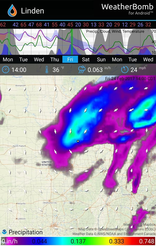
Possible late Feb snow event to impact IA this Friday the 24th. Way early to tell locations and amounts and temps will be fairly warm. Nevertheless, it should be a fairly potent storm with a large deformation zone.
0 notes
Text
Slow down!!!
...Slick Roads Anticipated Through The Evening... Shallow Blowing Snow And Re-Freeze From Previous Wet Roads Will Lead To Slick Roads And Hazardous Travel This Evening As Temperatures Slowly Drift Further Below Freezing. Visibilities May Be Down To A Mile Or Two In Blowing Snow...And Possibly Less In Open Rural Areas. Motorists And Pedestrians Are Urged To Use Caution This Evening And Anticipate Changing Conditions From Location To Location. Untreated Secondary Roads...Sidewalks And Side Streets Will Be Especially Susceptible To Becoming Slick And Icy.
0 notes
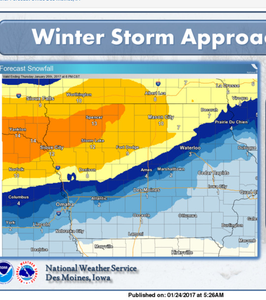
Photo
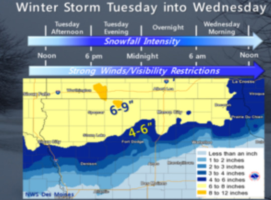
Dsm area looks to receive very little snow, if any. Northern IA looks to get heaviest amts.
0 notes