#* Navigation GPS
Explore tagged Tumblr posts
Visit Tumblr Blog
Explore Tumblr blogs with no restrictions, modern design and the best experience.
Last Seen Tumblr Blogs


Fun Fact
12.7% of mobile users access Tumblr.
Text
Modern day AU in which Odysseus is just driving an old Honda Odyssey with a really bad gps.
#epic the musical#greek mythology#epic odysseus#odysseus epic the musical#odysseus#lost af#gps and navigation#polyphemus was a hit and run#idk if he has good enough insurance for this#beep beep motherfucker
269 notes
·
View notes
Quote
To have faith in God, you must also have faith in His timing....
Brandi N. Jefferson-Motley, Your Soul's Navigational GPS
#quotes#Brandi N. Jefferson-Motley#Your Soul's Navigational GPS#thepersonalwords#literature#life quotes#prose#lit#spilled ink#inspirational-quotes
114 notes
·
View notes
Text


It’s hiking and field tech season so I’m projecting all my shenanigans onto the Trigun gang.
#trigun#vash the stampede#meryl stryfe#vashmeryl#milly thompson#nicholas d. wolfwood#newtsdoodles#have another silly au in these trying times#the trying times are me navigating on on-x to gps points that may or may not have wildlife in them.#Mileage may vary. Literally I think I hiked almost 16 miles yesterday.#anyways.
184 notes
·
View notes
Text


The Tametebako or Colloquially "Fuchi's Last Stand" was a no holds bar, money is no object vanity project by an unsupervised faction of Fuchi Asia. The stated goal was to make a completely unmatched bleeding edge piece of tech that could compete with the best static units while being a portable terminal replacement. Aimed at the Newly minted UltraLux CEO Segment, The Tametebako was made from rare and hard to get materials to sell it's exclusive nature; bundled with its innovative hardware and extremely powerful Otohime Assistant Software (Which Fuchi spend 10 years developing). Consequently, The Tametebako Commlink retailed at 50 000 nuyen which many consumers balked at for what was essentially an overpowered phone with an extremely intelligent chatbot. Many reviewers sledged the device for it's inability to install new applications if they weren't from approved sources. These Commlinks are now seeing second life in the collectors and hackers markets with finding the styling and theming of the phone to be charmingly retro and powerful enough to keep up with modern hardware with some QoL mods. Diehard fans report the Otohime software taking on a life of it's own after modding the hardware; her usual calm and dignified demeanor shifts around and changes during the jailbreaking process due to the random voltage pulse needed to defeat the modification lockout chip. This results in a unique iteration of the Soft on each device. SinkaSwim P2.0Net
#Shadowrun#Otohime#im fuckin free#rendering devices is hell#but im glad i did it#the deep lore on this is shes a normally digified character#but with say some offcolour shit off the cuff before rephrasing to sound more polite#originally envisioned her as a gps navigator but gridguide beat my ass
167 notes
·
View notes
Text

hihi! i figured i’d share this for anyone who is interested! what started out as a way for me to get to know rowan and play the new pack has now deviated into… something more O_O
so the current gp is an alternate universe of Tessellate and the choice made that changed certain events was Rowan choosing to move on from Atlas in part two of White Rabbit. i can’t go too much into detail about that part though for spoiler reasons but yeah! nothing about this is canonically correct but we do get to learn about rowan, how he evolved through change and see some events that do take place in White Rabbit!
also because my mind has been racing over the what if’s or how certain character arcs changed, here are some things that occurred to me in thought! all hypothetical of course bc i know there’s one part here that might get a few (it got me LMAO):
The whereabouts of Atlas are completely unknown at this point as he separated himself from the friend group, thus leaving himself completely unchecked
☆ Atlas never developed a connection with Taryn
☆ Taryn in return has remained in a similar state in which she was introduced, which is this state of feeling like things are stable in her life but incredibly stagnant.
☆ Dan still met Ares, but I’d like to think things went a bit more smoothly
☆ Kai does come out of the closet much sooner however, he and Taryn do have their disagreements from time to time but it’s more subtly as Taryn doesn’t really have that confidence to speak up
☆ Frances… Wouldn’t have needed another source of income so… They never met Icarus BWUGHHHH ! i mean maybe they could have met in some different way....??? hmm
#there’s a theme here of being lost which is also cool bc i sorta felt this way going into it#not in a negative way but it’s like navigating a story while utilizing what’s happening in game but removing the pressure of perfection#it feels a lot like self discovery for both me and the characters :)#also i wanted to say how i wrap up this gp is pretty freaking rad but i won’t say much about that#hmm gonna tag this in…#a year in nordhaven: extras
21 notes
·
View notes
Text
How Timepulse Works
Hey everyone, so… this was supposed to be a reply to a question from the esteemed @wary-taru, but the topic turned out to be pretty broad, and in my humble opinion, it doesn’t really fit the “question-answer” format, so I decided to make a separate post. ¯\_(ツ)_/¯

In case anyone forgot, let me remind you: Timepulse on Atmos works as a local navigation system, kinda like Atmos’s version of Earth’s GPS, and, jumping ahead, I’ll say right away that it seems to work on a similar principle, but, as often happens, a little differently. How exactly? Let’s find out.
How GPS Determines Location

So, before talking about Timepulse, I need to briefly explain GPS, since they should work the same in their most basic principle. As we all know from school, distance = speed * time. For us, this means that if we have a radio signal source whose location is precisely known, then, knowing the speed of light (299,792 km/s - veeery fast! >:D) at which radio waves travel, and the send and receive times of the signal, we can determine the distance to the transmitter. Therefore, if we know the distances to just 3 GPS satellites, then through something called the scary word “trilateration,” we can accurately determine our location on Earth. Okay, we’ve covered GPS, now let’s move on to Timepulse.
How Timepulse Determines Location

So, as we learned, the basic principle of GPS is calculating the distance to a transmitter based on the send and receive times of the signal. And the tower on Terra Glockenchime should perform the exact same function - sending a signal with the send time throughout Atmos so that everyone else can receive it. Now it’s clear why all that clock equipment is on Glockenchime. :D
But, I believe the most attentive of you should have already noticed that GPS needs 3 satellites to determine location, but there’s only 1 tower on Atmos. And, as you’ve probably already guessed, that’s where the difference lies. Now let’s see how this system works.

As with GPS, we need to calculate the distance, only not to a satellite, but to Glockenchime. However, one landmark isn’t enough; we need at least one more. As one, we can use, for example, the direction to the North Pole. So, now that we have the distance to Glockenchime, we can measure the angle between the direction to it and the direction to the North Pole. That will be the second landmark. Thus, through some not-so-complex trigonometry, Atmosian ships can calculate their location. But, as you might have already guessed, there’s one thing in all of this that we just can’t fail to mention. Namely - the accuracy of the measurements.
Atomic Clocks

So, if we measure the distance from the transmitter to the receiver through the travel time of the signal, we need to measure time very accurately, because with such a huge speed as the speed of light, even the slightest inaccuracy will be critical. To accurately measure such quantities, atomic clocks with accuracy down to attoseconds (one billionth of a billionth(!) of a second) are used on Earth. And… I wouldn’t say that the gear-driven equipment on Terra Glockenchime has the same accuracy as atomic clocks, so that gives us the right to assume that the signal sent by Timepulse travels much slower than the speed of light, otherwise the measurement errors would be just huge. And also, it’s worth noting that because not everyone can afford an atomic clock, all civilian GPS receivers, like in phones, are forced to use 4 or more satellites to achieve sufficient accuracy - and, as you’ve probably already guessed, even then it remains not very high. ¯\_(ツ)_/¯
Limits of Operation
So, since the canon doesn’t talk about the limits of Timepulse’s operation, we can’t say for sure whether it would work or not work at some distance/in some area (except, of course, the Great Expanse). However, judging by the fact that it radiates in all directions, its signal should weaken according to the inverse-square law. That is, if you move 2 times further from the source, the signal will weaken 4 times. Timepulse’s power isn’t reported in the show, but I would say that it can hardly operate beyond a few thousand kilometers. In any case, the canon data allows us to talk about such distances, but this is all, of course, inaccurate. ¯\_(ツ)_/¯
So… I think I haven’t forgotten anything. Then that’s all for today. Thanks for your attention, bye!
16 notes
·
View notes
Text
If The Silmarillion characters were in modern-day situations:
1. Fëanor at a parent-teacher meeting:
"Curufin cannot be second in class. This is absolutely unacceptable. Who’s this kid who outperformed him? I’ll talk to them personally!"
2. Fingolfin in line for coffee:
"Excuse me, what? My brother just took the last latte?! I don’t care how many orcs he’s defeated, I challenge him to a duel... for the coffee!"
3. Maglor and his Spotify playlist:
"Yes, my music collection is impressive. Oh, that? Yeah, that’s ‘Baby Shark,’ and so what? Even the great warriors of Middle-earth need a break sometimes!"
4. Maedhros and GPS:
GPS: "In 500 meters, turn left."
Maedhros: "I know a shortcut!"
One hour later: "Why are we back in Angband?"
5. Thingol and online shopping:
"I was looking for royal robes and accidentally bought half of Beleriand… Again. Melian, help me return this."
6. Glorfindel at a sports event:
"You think dying in battle against a Balrog is impressive? How about running a marathon in full armor and still winning?! #Easy"
#lord of the rings#the silmarillion#tolkien#fanfic#silm fic#silmarillion#lort of the rings#fëanor#feanaro#curufin#fingolfin#nolofinwe#maglor#kanafinwe#makalaure#maedhros#nelyafinwe#maitimo#thingol#glorfindel#laurefindele#online shopping#parents' meeting#the silmarilion#the silm fandom#lort#humor#gps and navigation#angband
39 notes
·
View notes
Text
#acuratl#navigation gps#buffer#carpartsforsale#car parts#rightchoiceautoparts#vehiclerepair#dailydeals#rightchoiceharhor
0 notes
Text

Somewhere, 2025
GPS
12 notes
·
View notes
Text

🌴🦁 jungle max jungle max jungle max 🌴🦁
#this has no business being this cute and funny 😭💘😭💘😭💘😭💘😭💘😭💘😭💘😭💘#the way he calmly navigates his ridiculous lil cleaning machine 😭💘#max verstappen#singapore gp 2023#f1#*#**#weeeeeeee
124 notes
·
View notes
Text
well, shit is getting straight up untenable in Australia!
that's why we got a new bio, also because we are sick of the anon's just block us damn.
but no legit, they are fucking up the NDIS and THAT IS BAD, it's literally the only governmental support for all disabled people in Australia by the way it's the "national disability insurance scheme" aka NDIS.
so uh BAD, real bad, extremely bad, uber bad.


there's more, uh so yeah!!!! FUCK MAN.
I do hope people don't die, because this is just going to lead to people seeking help from the gov't dying in the meantime.
or if the gov't says "yeah your not disabled (is disabled) get zero accommodations loser" then well that's BAD.
I already know like tons of people who couldn't get NDIS money and they were straight up disabled, and people who desperately needed those accommodations and couldn't because the government just straight up would not listen and help them.
it's pretty fucking telling that more than half the disabled people I know in Australia literally could not get on the NDIS.
this is just making a already shit situation worse, I haven't been able to go to the dentist, GP, or the eye doctor people in more than 5 Years!!!!
FIVE FUCKING YEARS, I know people who are straight up 2 seconds away from being homeless due to not being able to work and not being able to apply to the NDIS.
like it's fucking bad, if your parents won't boot you off your centrelink you can't get your own centrelink and can't access any accomodations or disability money, if your blak (aka aboriginal) your just extremely fucked already now times that by 4.
like dude, THIS IS SHIT.
and I know disability ally's are mostly American based, but by fuck WHAT THE FUCK, THE ACTUAL FUCK MAN.
the NDIS is not perfect there's shit ton of corruption and scammers-
(I actually know a family who's like legit scamming the NDIS lol no I don't mean like "oh those physically disabled's" I mean like they are using the money on like 3d printers and shit lol they are assholes and racists)
but like, it was barely working for people before. this is going to take the people it was barely working before and fuck them over too.
it's gonna fucking suck man, I am fucking scared for everyone.
#-pop#activism stuff#disability#NDIS#auspol#ausgov#actually disabled#physical disability#invisible disability#cripple punk#cripplepunk#THE FUCK MAN#I know it doesn't sound that bad to the uninitiated but I grew up in the 2000s and you have 0 idea how expensive disability shit is without#the support from the government my family LITERATELY WENT INTO DEBT#I can't get diagnosed with ADHD and get meds. I can't even go to the GP for fucks sake without it being insane money#I have learning disabilities life is already hard as shit to navigate now add on the insane amount non-critical healthcare is?#FUCKED. it's so fucked.#disability advocacy#disability awareness#disability rights
26 notes
·
View notes
Text
Satellites: Their Orbits, Tracking Systems, and Essential Uses
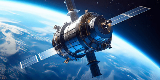
Satellites: Their Positions, Tracking, and Importance
Satellites have become an essential part of modern life, orbiting Earth and providing us with services ranging from communication and navigation to weather forecasting and space exploration. As of 2024, thousands of active satellites are circling our planet, each performing a specific role to enhance the quality of life on Earth. This article delves into the positioning of satellites, how they are tracked, what they track, and the significance of their roles.
Types of Satellite Orbits and Their Positions
Satellites are positioned in various orbits depending on their intended functions. These orbits determine how close the satellite is to Earth, how fast it moves, and what areas it covers.
Low Earth Orbit (LEO): Altitude: 180 km to 2,000 km Satellites in LEO include most Earth observation satellites, the International Space Station (ISS), and some communication satellites. These satellites are closer to the Earth, enabling them to capture high-resolution images. Functions: Used for imaging, remote sensing, and some communication purposes. Examples: ISS, Earth observation satellites like Landsat.
Medium Earth Orbit (MEO): Altitude: 2,000 km to 35,786 km Satellites in MEO are mainly used for navigation. This orbit offers a good balance between coverage and latency. Functions: GPS satellites and other global navigation systems. Examples: GPS, GLONASS, and Galileo satellites.
Geostationary Orbit (GEO): Altitude: 35,786 km above the equator Satellites in GEO move at the same rotational speed as Earth, meaning they stay fixed over one location on Earth. These are mostly communication and weather satellites. Functions: Used for television broadcasts, weather monitoring, and some types of communication. Examples: Weather satellites (GOES series), telecommunication satellites.
Highly Elliptical Orbit (HEO): Orbit shape: An elongated orbit with one point closer to Earth (perigee) and another point much farther away (apogee). Functions: Ideal for regions at high latitudes, providing prolonged coverage over areas like Russia and parts of Canada. Examples: Molniya satellites for communication in Russia.
How Satellites Are Tracked
The sheer number of satellites in space, combined with space debris, means tracking them is essential to avoid collisions and ensure their functionality. Ground stations and dedicated space agencies continuously monitor satellites. Several methods are used to track satellites:
Radar and Ground-Based Systems: Ground stations use radar to track satellites in LEO. These systems bounce radio waves off the satellite and measure the time it takes for the signal to return. By doing this repeatedly, they can track a satellite's location and speed.
Global Positioning System (GPS): Satellites in higher orbits like MEO or GEO are tracked using onboard GPS receivers. GPS helps calculate the satellite’s position and relay that data back to Earth.
Optical Tracking: Telescopes and cameras are used to visually observe satellites in higher orbits. This method is particularly useful for tracking objects that do not emit radio signals or need to be monitored for their physical characteristics.
Space Surveillance Networks: Agencies such as the U.S. Space Surveillance Network (SSN) and similar organizations in other countries continuously monitor satellites and space debris. They catalog objects and issue alerts for potential collisions.
What Satellites Track
Satellites are equipped with various sensors, cameras, and instruments to track a wide array of data on Earth, in space, and beyond:
Weather and Climate Data: Satellites such as NOAA’s GOES series monitor weather patterns, hurricanes, and long-term climate changes. They provide crucial data for meteorological services.
Earth Observation: Satellites like Landsat capture high-resolution images of Earth's surface. These images are used for mapping, agricultural planning, disaster response, and environmental monitoring.
Navigation Signals: GPS and other GNSS (Global Navigation Satellite Systems) satellites send signals that are used for navigation by smartphones, vehicles, ships, and airplanes worldwide.
Communication: Satellites facilitate global communication by relaying TV, radio, and internet signals across vast distances.
Space Exploration: Space telescopes like the Hubble Space Telescope track distant galaxies, nebulae, and black holes, helping scientists study the universe.
Military Surveillance: Many satellites are designed for defense purposes, tracking missile launches, military movements, or spying on potential threats.
Number of Satellites in Space
As of 2024, there are approximately 8,000 operational satellites orbiting Earth. The exact number fluctuates as new satellites are launched and old ones are decommissioned. Additionally, space agencies and private companies like SpaceX continue to launch large satellite constellations, such as Starlink, which alone has over 5,000 satellites in orbit for global internet coverage.
The Usefulness of Satellites
Satellites have become indispensable in modern life, serving a wide variety of purposes that impact everyday activities and critical global functions:
Key Functions of Satellites:
Communication: Satellites enable long-distance communication by transmitting data, television, and internet services. Without them, global broadcasting and real-time communication in remote areas would be impossible.
Navigation: Systems like GPS help millions of people navigate in real-time. They are also vital for the functioning of aviation, maritime travel, and even agricultural practices.
Earth Observation: Satellites provide high-resolution imagery of Earth, helping with disaster management, urban planning, agriculture, and environmental monitoring. For instance, they can track deforestation or observe glaciers' melting rates.
Weather Forecasting: Weather satellites provide the data needed for accurate predictions, storm tracking, and climate monitoring. This information is critical for preparing for natural disasters like hurricanes or floods.
Scientific Research and Exploration: Space telescopes and interplanetary satellites gather data on space phenomena, expanding our understanding of the universe. Satellites also conduct scientific experiments in the microgravity of space.
Defense and Security: Satellites are used for military surveillance, early-warning systems, and missile detection, playing a crucial role in national security.
Satellite Highlights in Brief:
Types of orbits: LEO, MEO, GEO, HEO, each serving different purposes.
Tracking methods: Radar, GPS, optical tracking, and space surveillance networks.
Data tracked by satellites: Weather, Earth observation, navigation signals, space exploration, and military surveillance.
Number of active satellites: Approximately 8,000.
Key roles: Communication, navigation, weather forecasting, Earth observation, scientific research, and defense.
In conclusion, satellites are essential tools for global communication, navigation, monitoring Earth's environment, and scientific discovery. As technology advances and the number of satellites continues to grow, their impact on our daily lives will only increase. Whether improving how we predict the weather, navigate through traffic, or explore the universe, satellites will continue to be a critical resource for humanity.
Go To How Satellites Work and What They Track
#satellite orbits#satellite tracking#satellite functions#low earth orbit#geostationary orbit#medium earth orbit#space technology#GPS satellites#communication satellites#weather satellites#Earth observation#satellite uses#satellite positions#how satellites work#space surveillance#satellite navigation#satellite networks#satellite importance#global navigation systems
7 notes
·
View notes
Text
I like to think Jack and Pierre have a narrator voice because after they got un-booked they ended up recording a GPS program to raise funds after their restaurant got shut down due to their absence.
#limbus company#library of ruina#jack and pierre#hey its a living#Heartwarming: Local Cannibal Chef Couple Raising Funds To Buy Their Restaurant Back After Coming Back From Library#a deleted scene from canto I does imply that the navigator voices are just GPS recordings (hence why theres ones of dead characters)#and I can't think of any reason why Jack and Pierre would be able to have one (Malkuth I guess they found in an L Corp ruin)
25 notes
·
View notes
Text
random thought but i feel like i have a deep understanding of Zoro. i miss turns even when google maps is telling me very specifically where to go. the thought of not having a navigation system or the ability to research a place that i’m going is my nightmare. to not even have a compass or map but be expected to know where im going? absolutely not. and forget anyone telling me landmarks in an unfamiliar place. “the bomb is in the clock tower” YALL KNOW WHERE THATS AT??? we have never been here before be so fr
#‘i was born in the wrong time’ NOT ME ID CRUMBLE WITHOUT GPS#couldn’t navigate myself out of a paper bag#i understand him#i am zoro he is me#i will need someone to hold my hand and guide me every step of the way#i am the straw hats worst nightmare#one-rambles
3 notes
·
View notes
Text
Got home from the bar after chris' show And dropping my coworker off without GPS I feel like such a big brain genius like who needs Google maps?? Not this cunt thats for sure
#i used offline maps to get there but i was too lazy to get my smartphone out of my bag for the way back#anyway for anyone scared to switch to a flip phone because of navigation: offline google maps totally works#my old smart phone is literally just an mp3 player and emergency gps device at this point#and also my solitaire machine#anyway tip your bartenders
2 notes
·
View notes