#3D Mapping Projection
Explore tagged Tumblr posts
Visit Tumblr Blog
Explore Tumblr blogs with no restrictions, modern design and the best experience.
Last Seen Tumblr Blogs


Fun Fact
Kazakhstan’s Minister of Communications and Informatics has blocked the Tumblr site because it contained 60 sites of terrorism, extremism, and pornography in 2015.
Text
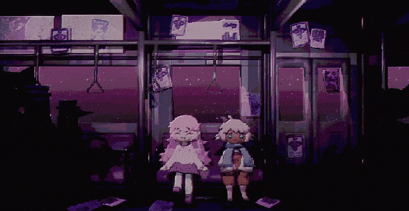
twilight train
#i feel the need to improve old maps and environments#will take awhile but i’ll feel much better about this project#gif#game dev#3d art#oc
805 notes
·
View notes
Text
212 notes
·
View notes
Text
Multi Animator Project - Finding Frankie
Attention FF Animators! I have a Multi Animator Project open to join! We still have spots open so come join us!
youtube
Please I really wanna fill those spots!
#firey doodles#finding frankie#toon frankie#other frankie#monster frankie#henry hotline#map#multi animator project#2d animation#3d animation#animation#animated#digital animation#rabbit#blender 2d#toon boom harmony#adobe animate#flipaclip#too many tags#lucky contestant#noob noobs#Youtube
7 notes
·
View notes
Text

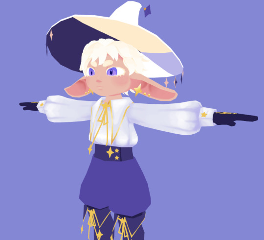
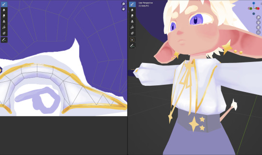
im in texture paint hell
#3d#wip#the first pic is when i did the body uv map for the texture paint lol#since i used flat colors as placeholders before and just used project from view to assign colors#idk what im doing wrong but my shoulder always gets so sore from drawing on the computer#maybe i should just take more stretch breaks#i like the look of these soft painterly textures but man is it a lot of work#also i never do soft shading when im drawing because i cant be bothered#so im kinda in foreign territory also lmao
124 notes
·
View notes
Video
youtube
luminbird @imapp 2024
Jury Award at iMapp Bucharest – Winners League 2024 – Legacy' 'Luminbird' 3D/ video: Ivó Kovács Music: József Iszlai Original 'Big-wing' motion courtesy of Derengo Animation, special thanks to La Luz. Organizers: Municipality of Bucharest, through CREART – Centre for Creation, Art, and Tradition of Bucharest iMapp Bucharest – Winners League partner: Parliament of Romania – Chamber of Deputies iMapp Bucharest – Winners League International partners: Chongqing Light Festival – CHINA, Video Mapping Festival Lille – FRANCE, Genius Loci Weimar Festival – GERMANY, 1minute Projection Mapping Competition – JAPAN, Zsolnay Light Festival – HUNGARY, ILO – International Light Festivals Organization
#3dmapping#imapp#imapp2024#imappbucharest#winner#bucharest#piataconstitutiei#jury's award#videomapping#videoart#bucuresti#projectionmapping#3d#ivo3d#3dvideomapping#projection-mapping#madewithnotch#parliament#luminbird#projection-art#newmedia#architectural-mapping#artists on tumblr
11 notes
·
View notes
Text
happy project ceaser day to those who celebrate
im frothing at the fucking mouth in excitement
3 notes
·
View notes
Text
Saturn Valley TF2 - Dev Updates
Here are some of the latest development updates for my Saturn Valley map for TF2.
-There is now a 3D Tessie lurking in the water, and he emerges whenever there's no one nearby. If you approach and get close, he quickly dunks back under the water.
-UFOs are now scattered around the map, used for making your way around. A Cute Lil UFO can carry you around the sky if you jump into its beam. Regular UFOs will catapult you from one point to another.
#earthbound#saturn valley#mother 2#nintendo#gaming#mods#maps#mapping#modding#mine#project#wip#3d#blender
5 notes
·
View notes
Text
ia/vt colorful wet cat ia model

#bobtalk#what ive been up to lately?well i've been getting into ia/vt colorful wet cat ia 3d model#seeing. say. projectdiva miku makes me happy because it's miku and i love her.#seeing the ia model from this game makes me happy because it's so so incredibly moe#exactly how 12y/o me pictured her in his mind. in all her wonky 3d glory. looking like a wet cat. bless.#(other stuff: i have a map part i need to work on. and i havent touched my project in a while because im starting to hate it lol.)#(school starts back up soon :( but we stay fighting)#(and meanwhile: wet cat ia)
5 notes
·
View notes
Text
minor grimodelling update:

#no renders of it right now bc im SO sleepy#but#its#so detailed#and unnecessary#I need to think of fun or silly shit to pose in it.. hmmm#also holy fuck my respect for 3D artists of all stripes has increased by 700% over the course of this project#im working with premade assets that have textures and uv maps and rigging and (some) animations handled#and shaders and lighting and posing and camera work and render settings and crap takes SO MUCH time and effort#if I was doing the modelling/texturing/rigging from scratch too I would simply die
2 notes
·
View notes
Text
Projection Mapping
Empressio redefines storytelling with cutting-edge Projection Mapping technology. We transform physical surfaces—walls, buildings, stages—into interactive, animated environments using high-resolution 2D and 3D visuals. Ideal for events, product launches, and facade shows, our mapping services are fully customizable and synchronized with lighting and sound. Empressio’s creative and technical teams handle everything from concept to execution, delivering unforgettable experiences that captivate audiences and elevate your brand presence. Discover the art of light with India’s leading projection mapping experts.
0 notes
Text
In today’s real estate world, everything moves fast. Buyers want more clarity, investors expect transparency, and developers need smarter ways to manage and showcase their projects. That’s where digital twin technology is stepping in to change the game. It’s no longer just about blueprints and brochures. Now, it’s about creating a live, interactive digital version of a real-world property that gives everyone involved a better experience, from planning to selling.
#3D solutions for real estate experience#3D mapping platform for real estate#interactive 3D mapping services for real estate#3D visualization solutions for property developers#virtual site tours for real estate projects#digital twin technology for real estate#web-based 3D walkthroughs for real estate#real estate experience with interactive 3D visuals#gamified property exploration tools#interactive location mapping for real estate
0 notes
Text
Understanding the Importance of Water Utility Surveys
Water is a fundamental resource that sustains life, and the infrastructure supporting its supply and distribution is a critical component of urban and rural development. A water utility survey plays a pivotal role in ensuring the efficient and sustainable management of water resources.
Learn more at https://www.cyberswift.com/blog/water-utility-solution-detailed-overview/

#3D mapping for water utilities#Digital mapping for water utilities#GIS-based water utility mapping#Hydrographic utility surveys#Remote sensing for water pipelines#Surveying for water utility systems#Underground water pipeline surveys#Utility mapping for water projects#Water distribution network survey#Water distribution system assessment#Water infrastructure surveys#Water leakage detection surveys#Water pipeline mapping#Water pipeline monitoring solutions#Water supply network survey#Water utility asset management#Water utility inspection surveys#Water utility network monitoring#Water utility survey services
1 note
·
View note
Text
Sneak-peak of a light art group exhibition at Fénydóm Budapest/ my cell/part - 'instinct - ancestor' (omnisphere 2017 animation variant/adapted to the given space) from 01.03.2024 - 17.03.2024, another projection-mapping installation.
#fénydóm#fenydombudapest#biodom#media artist#visual#loop#artists on tumblr#budapest#ivo3d#3d#lightart#light art#installationart#new media#projection#primordial#projection mapping#videomapping#video art#generative#generative art
20 notes
·
View notes
Text
How Digital Twins Can Be Used in Transportation Projects

Digital twins, a cutting-edge technology offering living virtual replicas of physical infrastructure, are transforming the transportation field.
By creating digital twins of highways, bridges, and railway networks, planners and engineers gain an interactive, data-driven model of the entire transportation system.
This 3D mapping for transportation projects not only provides insights into current operations but also enables advanced capabilities like predictive maintenance and real-time traffic optimization.
What Is a Digital Twin?
A digital twin is a digital replica of a physical asset or infrastructure that integrates real-time data through IoT sensors, cloud computing, and analytics.
In transportation, digital twins simulate traffic patterns, monitor infrastructure conditions, and forecast potential disruptions, enabling more accurate, effective decision-making.
With real-time data and predictive analytics, these digital twins allow transportation agencies and engineers to anticipate issues, optimize traffic flow, and streamline the development of new projects.
The Role of Digital Twins in Transportation Projects
Digital twins offer a multifaceted toolkit for transportation planners, engineers, and city planners, addressing the complex needs of large infrastructure systems.
Here are several ways digital twins can support transportation projects:
Real-Time Traffic Monitoring and Control
Digital twins provide dynamic, real-time traffic monitoring capabilities that can revolutionize how traffic is managed. As demonstrated in a digital twin of the Geneva Motorway, the suggested model continually updates traffic simulations using live data from roadside sensors.
This real-time modeling allows transportation operators to monitor traffic conditions and adjust strategies like variable speed limits or ramp metering to alleviate congestion quickly.
In Chattanooga, real-time traffic changes made through the help of digital twin technology decreased traffic delays by 32%.
This could be revolutionary for traffic flow management.
Enhanced Infrastructure Maintenance and Predictive Analytics
Transportation infrastructure such as bridges, tunnels, and highways require regular monitoring to prevent costly and dangerous failures.
Digital twins enable predictive maintenance by continuously assessing the health of structures based on real-time data.
For example, sensors embedded in bridge structures can detect minor changes or stress factors, allowing maintenance teams to proactively address issues before they become significant problems.
Using 3D mapping for transportation projects, digital twins can provide detailed visualizations of infrastructure wear and tear, streamlining inspection processes and enabling more precise interventions.
Improving Road Safety Through Simulations
By merging real-time data with 3D mapping for transportation projects, digital twins enhance road safety.
In simulated environments, engineers can test potential safety measures such as traffic light adjustments, signage changes, and speed limit modifications to see how they would impact traffic flow and accident rates.
In emergency situations, digital twins provide a critical tool for monitoring road conditions and managing emergency responses, helping direct resources to high-traffic areas or hazardous zones.
Environmental Impact Analysis
With transportation projects increasingly focused on reducing environmental impact, digital twins play a crucial role in monitoring emissions, fuel consumption, and even noise pollution.
The environmental footprint of different strategies can be simulated and adjusted, allowing engineers to assess eco-friendly alternatives with minimal physical disruption.
Facilitating Urban and Suburban Mobility Planning
City planners are now adopting digital twins to understand and manage urban transportation systems more effectively.
Through 3D mapping for transportation projects, planners can gain insights into how new developments or infrastructure changes might impact traffic patterns, parking demand, and public transit usage.
This approach has shown promise in improving coordination between transportation agencies, urban development authorities, and even environmental agencies, creating more sustainable cities.
Training and Simulation for Emergency Planning
Digital twins are invaluable for training transportation operators, first responders, and traffic management personnel.
Simulations can replicate real-world traffic scenarios, providing emergency planners with a safe environment to practice responses to natural disasters, accidents, and peak congestion periods.
This makes digital twins not only a technology for planning and optimization but also a proactive tool for public safety.
The Future of Digital Twins and 3D Mapping for Transportation Projects
The potential of digital twins is only beginning to be realized. As 3D mapping for transportation projects becomes more refined, the scope for integrating digital twins across city and state-level transportation networks will expand, potentially reshaping how we manage and develop infrastructure.
By combining live data streams, real-time simulation, and predictive modeling, digital twins offer a powerful, data-driven approach that’s set to redefine modern transportation projects.
0 notes
Text
youtube
Project 2: A Journey through Digital Media Arts
Artist Research
A'strict "Whale #2" Whale #2 by a'strict is a digital art installation that uses projection mapping and 3D animation to simulate a massive whale swimming in a virtual body of water, creating a stunning visual experience. The public media art situated in New York's Times Square was created by ‘a'strict,’ an art team from South Korea. The whale made of water, swimming in the waves, and eventually vanishing within the waves. This creation took place during the phase of the COVID-19 pandemic, and the a'strict team conveied soothing energy to the public through their artwork. The visual effect is astonishing and makes me feel the immense power of nature. It somehow symbolizes the freedom that people constantly seek. We aspire to be like the swimming whale, freely diving in the sea. Moreover, the enormous whale forms a contrast with the bustling crowds of pedestrians in front of Times Square. d'strict (2021) Whale #2 [Online video], 26 August. Available from: <https://vimeo.com/1https://www.youtube.com/watch?v=PvOTMXAOyoY&t=1s66807261> [Accessed 6 October 2024].
0 notes