#Colossive Cartographies
Explore tagged Tumblr posts
Visit Tumblr Blog
Explore Tumblr blogs with no restrictions, modern design and the best experience.
Last Seen Tumblr Blogs


Fun Fact
The most popular pages on Tumblr are about Minecraft, GIFs, and David J. Peterson.
Text
Indie publisher Colossive Press will be celebrating five years – and 66 issues, and counting – of their Colossive Cartographies series next month, with a birthday bash at the amazing Gosh! Comics in London, on Friday 20th June 2025.
#Blaise Moritz#Colossive Cartographies#Colossive Press#Ed Pinsent#Gareth A. Hopkins#Gosh! Comics#Jane Gibbens Murphy#Joe Stone#Lucy Sullivan#Miranda Smart#Olivia Sullivan#Peony Gent#Sean Azzopardi#Tim Bird#Tom Murphy
2 notes
·
View notes
Text

A wonderful evening with Tom and Jane of Colossive Press as they celebrate their 5th Birthday.
They print many things, but the Cartographies are a beautiful little format for visual storytelling. On the table you can see all 66, and what an inspirational and diverse range of experiences, tales, and artwork they represent!
0 notes
Text
COLOSSAL

Carl Chun, Polypus levis, from Die Cephalopoden (1910–15), color lithograph, 35 × 25 centimeters. Image from the Biodiversity Heritage Library/Contributed by MBLWHOI Library, Marine Biological Laboratory, Woods Hole Oceanographic Institution Library, Massachusetts.

NNtonio Rod (Antonio Rodríguez Canto), Trachyphyllia, from Coral Colors, (2016). Image © NNtonio Rod
Despite thousands of years of research and an unending fascination with marine creatures, humans have explored only five percent of the oceans covering the majority of the earth’s surface. A forthcoming book from Phaidon dives into the planet’s notoriously vast and mysterious aquatic ecosystems, traveling across the continents and three millennia to uncover the stunning diversity of life below the surface.
Spanning 352 pages, Ocean, Exploring the Marine World brings together a broad array of images and information ranging from ancient nautical cartography to contemporary shots from photographers like Sebastião Salgado and David Doubilet. The volume presents science and history alongside art and illustration—it features biological renderings by Ernst Haekcl, Katsushika Hokusai’s woodblock prints, and works by artists like Kerry James Marshall, Vincent van Gogh, and Yayoi Kusama—in addition to texts about conservation and the threats the climate crises poses to underwater life.
Ocean will be released this October and is available for pre-order on Bookshop. You also might enjoy this volume devoted to birds.


#Carl Chun #polypus #cephalopoden
#1910-15 #lithograph #ilustration
#original art #science #art #xpuigc
#Carl Chun#Polypus levis from Die Cephalopoden#1910–15#lithograph#illustration#original art#art#xpuigc
10 notes
·
View notes
Text
Colossive Cartographies #63 - Explore the...
A Third Act for Ed Pinsent: Unveiling the Surreal in Colossive Cartographies #63 Ed Pinsent, the celebrated UK small press comics luminary, returns with a third entry in Colossive Press’s riveting Cartographies series. This entry spotlights his distinctive creative vision, marking a reminder of why he’s a beloved figure in the indie comic scene. With contributions to both Cartographies and the…
0 notes
Text
Source notes: Cave Gave Game: Subterranean Space as Videogame Place
(Jerz & Thomas, 2015)
Type: Journal Article
Discipline: Ecology/Critical Analysis
Relevance: 1/5
An essay examining how humans experience cave spaces through the lens of computer games.
It begins by giving a more detailed account of the history of Colossal Cave Adventure, telling of how it was based on the Mammoth Cave System in southwestern Kentucky, and the moment when Pat Crowther, the wife of that game's creator, "squirmed through a muddy tunnel in September of 1972, she formed the final link in the chain, thereby establishing Mammoth as the world’s most extensive subterranean network – that is, the “longest cave.”". It explains the motivation behind the creation of the game as a way for William Crowther to connect with his daughters and impress his Dungeons and Dragons friends. The importance of Colossal Cave Adventure within the context of understanding human interaction with caves is claimed due to its relationship with real world caves and the fact it embodies "their meanings as places of mystery, shelter, wonder and leisure."
It is argued that by making players experience the virtual cave of Colossal Cave Adventure through text and the sharing of its source code via the internet (allowing others to extend it), the idea of caves as a computer game setting and assumptions regarding their design were seeded in gaming culture at a formative stage.
The essay contains an interesting note on how the game came to be released:
"Crowther worked on his game during the 1975-76 academic year, showing it to his children when they came to visit him during school breaks. Jerz’s interviews with Crowther and his family support the 1975-76 span, and no evidence contradicts it. At some point after Crowther stopped working on the game, Stanford University grad student Don Woods found it on a computer at the Stanford campus, expanded it, and re-distributed it online. While Woods has offered 1976 as the date he published the collaboration, the earliest extant version of the Crowther/Woods version is dated 1977. Woods acknowledges Adventure’s parser was primitive (qtd. in Montfort 89), and notes that the game had nothing to do with the professional activities of the Stanford Artificial Intelligence Laboratory (Woods)"
As with (Rautzenberg, 2020), a parallel is drawn between cartography as a core part of speleology and the prominence of maps in many games, with gameplay often involving the filling, marking and interpreting of maps, as well as the player having to rely upon them when other views of the environment are in some way obscured. To further explore the games as caves metaphor, (Jerz & Thomas, 2015) highlight the use of items and the activity of resource management being common to both caving and RPGs, as illustrated in an account by cavers of exploring the Mammoth Cave System: "The Longest Cave illustrates cavers dealing with resource- and inventory-management decisions that are a large part of role-playing games". One could argue that there are other activities and disciplines that could be claimed to share said commonalities with games, such as rock climbing and metal detecting, undercutting the suggestion that caves and speleology in particular have influenced, or are an especially apt metaphor for, adventure games.
The majority of the remainder of the essay continues along the same lines, investigating ways in which caves and the influence of Colossal Cave Adventure mirror or might have influenced game design and culture. Much of this is unrelated to the design and implementation of caves in games — in terms of best practices, how they vary, the technology and challenges involved in their creation — and so is considered outside the scope of the project.
A takeaway from (Jerz & Thomas, 2015) and (Rautzenberg, 2020) that may be worth including in the manuscript is that cave-like environments (not necessarily resembling rock-based systems) are efficient vehicles or solutions to game design problems when the aim is to implement many common adventure game features (possibly partially explaining their prevalence), such as treasure hunting, item use and discovery, the involvement of maps, exploration, and the connecting of disparate areas. The cited researchers would likely argue that those aforementioned features have become staples in some part due to a combination of the influence of Colossal Cave Adventure and inherent properties of caves, speleology and humans that in interaction with one another affect how people relate to the world around them (both virtual and real). As summarised by (Jerz & Thomas, 2015):
"Do video games reflect an influence of caves? Almost certainly. Thanks to Crowther, caves will be forever linked to the early development of the form. Further, caves, as a form of psychological symbol, would have surely found their place in the narrative structure of games. Dropping down into a cave is about leaving the familiar, surface world. Save for rare examples of the harvesting of bat guano or the occasional rescue operation, there is little practical reason to delve deeply into the maw of naturally existing caverns. Still, people dream about caves, wonder about caves, and finally one day charge head-first into the blackness that lurks just beyond the reach of their shiny brass lanterns."
However, such research paths stray too far from the technology, development, and to an extent design, focus of the project, for them to be included.
0 notes
Text
Ephemera

***


…
●
Ephemera
© photo-collages by hiromi suzuki, 2021
Pop-out zine published by Colossive Press, 2021
●
Colossive Cartographies is an attempt to create a print equivalent of a series of seven-inch singles using a simple pop-out A6-to-A4 format based on the Turkish map fold.
●
*Please check HERE: Colossive Cartographies: Series Four (19-24) Ephemera by hiromi suzuki (Colossive Cartographies 23)
...
#hiromi suzuki#Ephemera#pop-out zine#leaflet#zine#collaboration#visual poetry#vispo#collage#photo-collage#photography#Colossive Press#Colossive Cartographies
6 notes
·
View notes
Text
Colossive Cartographies #22-32 - The Pandemic, Joni Mitchell, Mental Health Awareness and a Fear of Wasps Feature in the Latest Releases from Colossive Press
Colossive Cartographies #22-32 – The Pandemic, Joni Mitchell, Mental Health Awareness and a Fear of Wasps Feature in the Latest Releases from Colossive Press
Whenever I review the Colossive Press Colossive Cartographies series there’s an obvious piece of necessary introductory housekeeping that needs to be addressed first for those unfamiliar with these tactile zines and their interactive format. Each one is an example of the Turkish Map Fold – a process that takes an A4 sheet, folds it into an A6 cover that then opens up as an interactive…

View On WordPress
#aleesha nandhra#colossive cartographies#colossive press#elizabeth querstret#Gareth Brookes#jenny robins#mental health awareness#mereida fajardo#pandemic comics#peter morey#rebecca k. jones
0 notes
Text

The Colossal Snail Battle Map
Our latest map-sized-token is the Colossal Snail, which just went up on the website! This critter is large enough to bear a house on its back. Will your party rescue it?
➝ Download it on 2-Minute Tabletop
ttrpg, tabletop, dungeons and dragons, dnd, dungeons & dragons, d&d, d&d5e, dnd5e, pathfinder, gurps, rpg, top-down, battle map, map, cartography, encounter, geomorph,
1K notes
·
View notes
Text
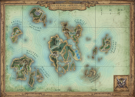
10 Lessons on Realistic Worldbuilding and Mapmaking I Learned Working With a Professional Cartographer and Geodesist
Hi, fellow writers and worldbuilders,
It’s been over a year since my post on realistic swordfighting, and I figured it’s time for another one. I’m guessing the topic is a little less “sexy”, but I’d find this useful as a writer, so here goes: 10 things I learned about realistic worldbuilding and mapmaking while writing my novel.
I’ve always been a sucker for pretty maps, so when I started on my novel, I hired an artist quite early to create a map for me. It was beautiful, but a few things always bothered me, even though I couldn’t put a finger on it. A year later, I met an old friend of mine, who currently does his Ph.D. in cartography and geodesy, the science of measuring the earth. When the conversation shifted to the novel, I showed him the map and asked for his opinion, and he (respectfully) pointed out that it has an awful lot of issues from a realism perspective.
First off, I’m aware that fiction is fiction, and it’s not always about realism; there are plenty of beautiful maps out there (and my old one was one of them) that are a bit fantastical and unrealistic, and that’s all right. Still, considering the lengths I went to ensure realism for other aspects of my worldbuilding, it felt weird to me to simply ignore these discrepancies. With a heavy heart, I scrapped the old map and started over, this time working in tandem with a professional artist, my cartographer friend, and a linguist. Six months later, I’m not only very happy with the new map, but I also learned a lot of things about geography and coherent worldbuilding, which made my universe a lot more realistic.
1) Realism Has an Effect: While there’s absolutely nothing wrong with creating an unrealistic world, realism does affect the plausibility of a world. Even if the vast majority of us probably know little about geography, our brains subconsciously notice discrepancies; we simply get this sense that something isn’t quite right, even if we don’t notice or can’t put our finger on it. In other words, if, for some miraculous reason, an evergreen forest borders on a desert in your novel, it will probably help immersion if you at least explain why this is, no matter how simple.
2) Climate Zones: According to my friend, a cardinal sin in fantasy maps are nonsensical climate zones. A single continent contains hot deserts, forests, and glaciers, and you can get through it all in a single day. This is particularly noticeable in video games, where this is often done to offer visual variety (Enderal, the game I wrote, is very guilty of this). If you aim for realism, run your worldbuilding by someone with a basic grasp of geography and geology, or at least try to match it to real-life examples.
3) Avoid Island Continent Worlds: Another issue that is quite common in fictional worlds is what I would call the “island continents”: a world that is made up of island-like continents surrounded by vast bodies of water. As lovely and romantic as the idea of those distant and secluded worlds may be, it’s deeply unrealistic. Unless your world was shaped by geological forces that differ substantially from Earth’s, it was probably at one point a single landmass that split up into fragmented landmasses separated by waters. Take a look at a proper map of our world: the vast majority of continents could theoretically be reached by foot and relatively manageable sea passages. If it weren’t so, countries such as Australia could have never been colonized – you can’t cross an entire ocean on a raft.
4) Logical City Placement: My novel is set in a Polynesian-inspired tropical archipelago; in the early drafts of the book and on my first map, Uunili, the nation’s capital, stretched along the entire western coast of the main island. This is absurd. Not only because this city would have been laughably big, but also because building a settlement along an unprotected coastline is the dumbest thing you could do considering it directly exposes it to storms, floods, and, in my case, monsoons. Unless there’s a logical reason to do otherwise, always place your coastal settlements in bays or fjords.
Naturally, this extends to city placement in general. If you want realism and coherence, don’t place a city in the middle of a godforsaken wasteland or a swamp just because it’s cool. There needs to be a reason. For example, the wasteland city could have started out as a mining town around a vast mineral deposit, and the swamp town might have a trading post along a vital trade route connecting two nations.
5) Realistic Settlement Sizes: As I’ve mentioned before, my capital Uunili originally extended across the entire western coast. Considering Uunili is roughly two thirds the size of Hawaii the old visuals would have made it twice the size of Mexico City. An easy way to avoid this is to draw the map using a scale and stick to it religiously. For my map, we decided to represent cities and townships with symbols alone.
6) Realistic Megacities: Uunili has a population of about 450,000 people. For a city in a Middle Ages-inspired era, this is humongous. While this isn’t an issue, per se (at its height, ancient Alexandria had a population of about 300,000), a city of that size creates its own set of challenges: you’ll need a complex sewage system (to minimize disease spreading like wildfire) and strong agriculture in the surrounding areas to keep the population fed. Also, only a small part of such a megacity would be enclosed within fantasy’s ever-so-present colossal city walls; the majority of citizens would probably concentrate in an enormous urban sprawl in the surrounding areas. To give you a pointer, with a population of about 50,000, Cologne was Germany’s biggest metropolis for most of the Middle Ages. I’ll say it again: it’s fine to disregard realism for coolness in this case, but at least taking these things into consideration will not only give your world more texture but might even provide you with some interesting plot points.
7) World Origin: This point can be summed up in a single question: why is your world the way it is? If your novel is set in an archipelago like mine is, are the islands of volcanic origin? Did they use to be a single landmass that got flooded with the years? Do the inhabitants of your country know about this? Were there any natural disasters to speak of? Yes, not all of this may be relevant to the story, and the story should take priority over lore, but just like with my previous point, it will make your world more immersive.
8) Maps: Think Purpose! Every map in history had a purpose. Before you start on your map, think about what yours might have been. Was it a map people actually used for navigation? If so, clarity should be paramount. This means little to no distracting ornamentation, a legible font, and a strict focus on relevant information. For example, a map used chiefly for military purposes would naturally highlight different information than a trade map. For my novel, we ultimately decided on a “show-off map” drawn for the Blue Island Coalition, a powerful political entity in the archipelago (depending on your world’s technology level, maps were actually scarce and valuable). Also, think about which technique your in-universe cartographer used to draw your in-universe map. Has copperplate engraving already been invented in your fictional universe? If not, your map shouldn’t use that aesthetic.
9) Maps: Less Is More. If a spot or an area on a map contains no relevant information, it can (and should) stay blank so that the reader’s attention naturally shifts to the critical information. Think of it this way: if your nav system tells you to follow a highway for 500 miles, that’s the information you’ll get, and not “in 100 meters, you’ll drive past a little petrol station on the left, and, oh, did I tell you about that accident that took place here ten years ago?” Traditional maps follow the same principle: if there’s a road leading a two day’s march through a desolate desert, a black line over a blank white ground is entirely sufficient to convey that information.
10) Settlement and Landmark Names: This point will be a bit of a tangent, but it’s still relevant. I worked with a linguist to create a fully functional language for my novel, and one of the things he criticized about my early drafts were the names of my cities. It’s embarrassing when I think about it now, but I really didn’t pay that much attention to how I named my cities; I wanted it to sound good, and that was it. Again: if realism is your goal, that’s a big mistake. Like Point 5, we went back to the drawing board and dove into the archipelago’s history and established naming conventions. In my novel, for example, the islands were inhabited by indigenes called the Makehu before the colonization four hundred years before the events of the story; as it’s usually the case, all settlements and islands had purely descriptive names back then. For example, the main island was called Uni e Li, which translates as “Mighty Hill,” a reference to the vast mountain ranges in the south and north; townships followed the same example (e.g., Tamakaha meaning “Coarse Sands”). When the colonizers arrived, they adopted the Makehu names and adapted them into their own language, changing the accented, long vowels to double vowels: Uni e Li became “Uunili,” Lehō e Āhe became “Lehowai.” Makehu townships kept their names; colonial cities got “English” monikers named after their geographical location, economic significance, or some other original story. Examples of this are Southport, a—you guessed it—port on the southernmost tip of Uunili, or Cale’s Hope, a settlement named after a businessman’s mining venture. It’s all details, and chances are that most readers won’t even pay attention, but I personally found that this added a lot of plausibility and immersion.
I could cover a lot more, but this post is already way too long, so I’ll leave it at that—if there’s enough interest, I’d be happy to make a part two. If not, well, maybe at least a couple of you got something useful out of this. If you’re looking for inspiration/references to show to your illustrator/cartographer, the David Rumsey archive is a treasure trove. Finally, for anyone who doesn’t know and might be interested, my novel is called Dreams of the Dying, and is a blends fantasy, mystery, and psychological horror set in the universe of Enderal, an indie RPG for which I wrote the story. It’s set in a Polynesian-inspired medieval world and has been described as Inception in a fantasy setting by reviewers.
Credit for the map belongs to Dominik Derow, who did the ornamentation, and my friend Fabian Müller, who created the map in QGIS and answered all my questions with divine patience. The linguist’s name is David Müller (no, they’re not related, and, yes, we Germans all have the same last names.)
#enderal#dreams of the dying#worldbuilding#resource#writeblr#writing tips#mapmaking#cartography#illustration#realism#writeblogging#novelwriting#writing research#research#writing
790 notes
·
View notes
Quote
Dialectical critique is affirmative, so here are my norms. Do critique: assess the environments for thought, and build necessary alternative environments. Commit to strengthening our institutions for critique and reflection and mediacy, precisely now when they’ve been decimated. Do the feminized service labor of making the place where we work work. Behold the university as a site of workplace struggle and as an immediate sphere in which it is possible to be effective, even on the colossal problem of the ecocide: organize to be sure your institution divests from fossil fuels, organize (and bargain fairly with) university laborers like faculty, contingent faculty, graduate students, and support staff, and then organize some more. In your teaching and writing, risk synthesis! Theory must work to build the world up. We must, in the present, make claims about causality, systematicity, and the revaluation of values, so we can make the very specific move to counter rapacious greed with rapid decarbonization. The dispersive poetics of attunement to the material world, romancing precarity, and dissolving binaries entice us to lie down. Critique and its cartography of other spaces enjoins us to stand up. … “Critique” and “crisis,” it is surely a literary cliché to note, have a common etymological origin in the Greek krínein κρίνειν, “to decide.” The extinction crises in theory and practice, in the university and on Earth, force a decision. It is too late, our ossified intellectual habits are dying, as are we—but crisis paralysis, romantic resignation, and arrested critique guarantee the worst. Wild imaginings, big abstractions, and brassy syntheses are less bad. Weak theory is a seductive siren, postcritique a consoling modesty. Go out strong.
Anna Kornbluh, “Extinct Critique,” South Atlantic Quarterly 119.4 (October 2020)
9 notes
·
View notes
Text
Sophisticated Indigenous “architecture of the rainforest” and the “slow violence” of savannification, extractivism, and corporate monoculture plantations: Paulo Tavares and using maps of environmental change to highlight “unofficial” and underreported state violence against Indigenous Amazonia.


Caption: “As this cartography shows, plotted over a map of the Amazon basin, the geography of political violence overlaps with the region known as the Arc of Fire (grey area), where deforestation is massive and the forest environment is currently undergoing a process of ‘savannization.’ Hundreds of blood stains (white crosses) are marked at the edges between forests and logging areas, cattle farms and plantations, thereby indicating that, in the deep frontiers of Amazonia, human rights violations and ecological devastation are intimately, indeed structurally, articulated, consisting in entangled dimensions of a violent political order that is driving climate change.”
Excerpts from Pedro Neves Marques, for Terremoto:
As the above image shows, the Amazon biogeographic region has become in many ways a “deadly environment,” drawn in the intertwining economics of climate change and the persistence of colonial violence in South America. The “Deadly Environment” map was produced by Paulo Tavares, Brazilian architect and researcher [...] The map is part of Tavares’s forensic and historical research, Amazonia: A Botanical Archaeology of Violence, on the “architecture” of the Amazon forest and the violence attached to its industrial development since the 1950s. Besides extensive archival material and a dialogue with archaeologists such as Michael Heckenberger and Eduardo Neves, he has been using satellite imagery and botanical knowledge to map and connect the age of the rainforest to genocidal crimes against indigenous communities close to extraction sites, such as the Waimari Atroari. In his own words, this “map compiles data on human rights violations gathered from reports produced by the NGOs Pastoral da Terra, Conselho Indigenista Missionário and Global Witness, in combination with GIS information on indigenous territories, location of dams and oil exploitation, and deforestation.”
To the East of the map one can see the absurd numbers of targeted assassinations and population displacement correlated to logging and deforestation, and to the West, as the rainforest rises from the states of Acre and Amazonas up the Peruvian and Ecuadorian mountain range, the Amazon appears transformed into a gigantic oil extraction site. At the center of the map, down from Santarém, lies the Belomonte Dam project and the Carajás mine, the biggest open air iron mine in the world, on the map also appears the biggest open air gold mine, located in Paracatu, in the state of Minas Gerais. To the South of the map, like a ravaging smile, there is the “Arc of Fire”, cutting across the state of Mato Grosso. This is perhaps one of the fastest and most intense terraformation sites in all of South America, whereby forest areas and the great plains of the southern Amazonian ecosystem have been transformed into vast monocultures of soy, corn, sugar cane, or cotton—here again, the map connects deforestation with the targeted killings of mostly indigenous populations and land activists.

--
Like the Mariana disaster, many more sites of violence mark the Brazilian territory outside of this cartographic boundary. These sites are characterized not only by direct, but also slow violence.
The accelerated monocrops of the agricultural states, for instance, are revealing, for they would not be possible without the intense use of pesticides and transgenic seeds. Brazil is the world’s first consumer of pesticides and other agricultural chemicals, with people ingesting on average up to six liters of pesticides a year, and some of the most chemical crops are those destined for biofuel and livestock such as soy, corn, sugar cane, and cotton.
Progress and production come at the cost of contamination and cancer; these regions are traversed, molecularly, by a pool of pesticides traveling in the subsoil and in the air, all of which deregulated like a colossal machine running on cheap or slave labor, and where the grid system of production and transportation stands above any human or nonhuman being or culture.
--
This landscape, toxic and contaminated by conflict, is the consequence of what in Brazil is called desenvolvimentismo (developmentism). For the corporatized Brazilian state, the modern way is the extractivist way, with little difference between today and the colonial Brazil of the entradas and bandeirantes (exploring and exploiting inner Brazil either for the Portuguese crown or privately, respectively).
--
Source: Pedro Neves Marques. “Brazil, Deadly Environment: Desenvolvimentismo in the work of Paulo Tavares and Beto Shwafaty.” Terremoto. 22 February 2016.
254 notes
·
View notes
Text
Colossive Cartographies - a small but perfectly formed comics and illustration project
Colossive Cartographies – a small but perfectly formed comics and illustration project
Small but feisty British independent publisher Colossive Press have announced that subscriptions for the first six issues of Colossive Cartographies are now open.

The project is an attempt from the Penge-based publisher, whose books also include such titles as the intriguing Ad Astra Per Croydon: The Lost History of London’s Forgotten Spaceportand the eye-catching book of unusual London…
View On WordPress
#Colossive Cartographies#Colossive Press#David Robert Bray#Jane Gibbens Murphy#Janie Murphy#Lucy Sullivan#Olivia Sullivan#Sean Azzopardi#Tom Murphy#Victoria Sellar
0 notes
Text


I made this Cartography Comic for Colossive Press. They have done a beautiful job putting it together.
I tried to explore the pivotal role women played in textiles, farming, and ceramics as humans moved from hunting and gathering to farming. In no small part inapired by the book the Dawn of everything. I hope I did a good job of it.
#pyjama cardinal#my art#making comics#comics#colossive press#neolithic people#the dawn of everything
5 notes
·
View notes
Text
honed his craft via the arduous pedagogical process of copying and repetition. Monitoring one’s breath is fundamental, a practice to which Qiu gives primacy in his series of wordless monochromatic paintings, Forms of Meditation (all 2022), comprising dunelike terrains (somewhere between landscapes and maps, often including a horizon line) born of a rhythmic to-ing and fro-ing that suffuses them with a colossal calm. Perhaps due to this embodied epistemology – uniting the conceptual with the painterly, the painterly with the calligraphic and back again, all intertwined with the topographical imagination – it seems the words were always supposed to be where they are. The colours in Three Flat-Topped Hills: At Dusk, and The Colour Experiments Series (2022), of which it is a part, are inspired by the chromatic representation of data by remote-sensing technology used to chart the radiation given off by the landscape, thus aligning body and breath with today’s most state-of-the-art – and disembodied – cartography. Qiu’s practice is not about conservative nostalgia or luddism; he repurposes ancient methods to attune the body to digital-age sensorial schema.
0 notes
Text
Colossive Cartographies #62: Harriet Merry
The Power of Context in the World of Zines There’s an intriguing dynamic within the world of Colossive Press and its Colossive Cartographies series. These zines find new life with additional context found online. Reading the zine first, without prior knowledge, alters your initial perception. When you finally dive into its digital listing, your introspection changes. The creative intent unfolds…
0 notes
Text
Source notes: Caves, Caverns and Dungeons: Speleological Aesthetics in Computer Games
(Rautzenberg, 2020)
Type: Book Chapter
Discipline: Media Studies
Relevance: 1/5
Opens by discussing Tomb Raider — specifically the popularity and iconic status of Lara Croft, and the subsequent discourse centred around the character — before making the argument that the real success and achievement of the 1996 title is not the protagonist, instead it "lies in the ways the game depicts and implements the exploration of caves, caverns and dungeons as a metaphor and gameplay mechanic" . The author states their aim of taking a speleological approach (speleology is the study of caves, essential to which is exploration and cartography) to forming an epistemology of computer game caves. That is, to consider computer game caves in terms of how they are explored and mapped by the player.
The author describes how one of the earliest computer games, the text-based Colossal Cave Adventure, was created by William Crowther, himself an amateur speleologist, using software for describing and mapping caves as its foundation. The virtual cave-systems of Colossal Cave Adventure contained treasure and enemies, with the job of the player to explore and progress by combining items and tools. Rautzenberg argues that the basic structure of adventure games has changed little despite their increased scale and the use of 3D graphics, based on the given description of Colossal Cave Adventure. That may be true in many cases, with it arguably depending on the particular approach used to abstract and describe a game's structure, however the criteria is of such a generic quality that applying it to modern adventure games does not say much about how they have changed or remained the same since 1976 when Colossal Cave Adventure was created.
Rautzenbreg proceeds to proffer that all games featuring polygonal landscapes are set in cave-like environments because of the use of sky-boxes and other impenetrable world boundaries. One could argue that this overlooks games that create the effect of a limitless environment using procedural generation and other techniques, as well as it being true for all forms of media when logically extended — boundaries must always exist for virtual worlds and characters (with the ultimate boundary being the form itself).
Much of the writing that follows does not discuss computer game caves in terms of their history, how they are used from a design standpoint, or how they have developed technologically, instead discussing: Plato’s allegory of the cave; how caves and speleology are suitable metaphors for games and the act of playing; and how player exploration, mapping and in-game maps themselves can be considered within the context of existing theories in media studies. Such content is considered out of as far as the project is concerned.
There are some interesting thoughts on the purpose of computer game caves being places to hide items, with the searching and finding of them, rather than the items themselves, being the important and engaging aspect of gameplay in many cases.
1 note
·
View note