#Landform Architecture
Explore tagged Tumblr posts
Visit Tumblr Blog
Explore Tumblr blogs with no restrictions, modern design and the best experience.
Last Seen Tumblr Blogs


Fun Fact
130K people were victims of a chain letter scam that affected Tumblr in May 2011.
Text

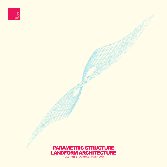
Landform Architecture Rhino3D Modelling FULL COURSE | Rhino Tutorial For Architects and Designers
In this course, we explore creating an architectural landform design from a basic surface operation.
#architecture#architecturediagrams#diagrams#architecturedrawing#rhino3d#3d#archtutorial#adobeillustrator#vectorart#rendering#infographic#graphicdesign#landforms#Landform Architecture
0 notes
Text
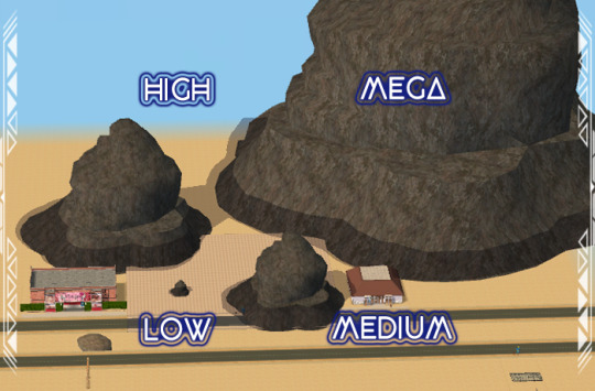
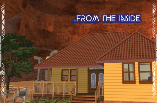
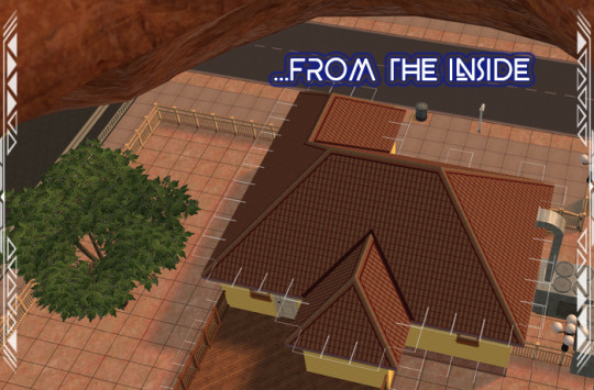
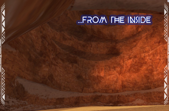
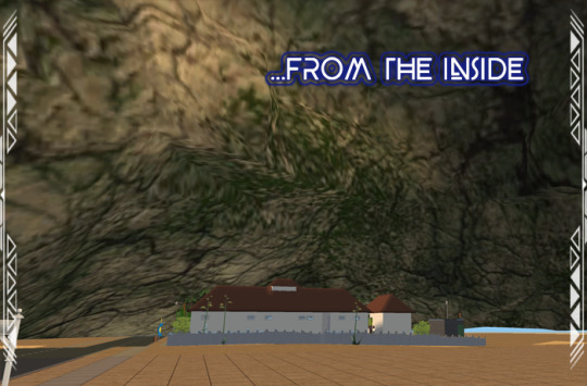
Desert Cliff 006
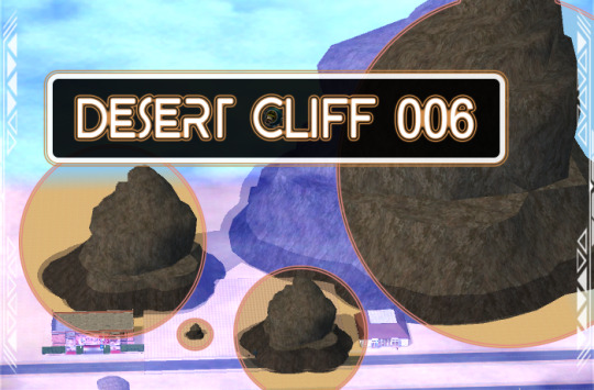
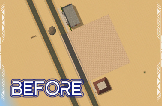
Published: 1-24-2024 | Updated: 1-26-2024 (Version 2 Hood View FIX) SUMMARY Here is a desert cliff (original model by WireframeArt, 2021 via Creative Commons Attribution) in FOURS sizes—Low, Medium, High, and Mega. Add a cliff or mix and match several to create unique landforms, visible from both lot and hood view. The High/Mega sizes are large enough to cover entire lots! Also, the interior of the object is visible so you can create scenic caves, grottos, mines, and other mountainous settings.
Pictured in between Lot 26 (2x3, 2-story) and Lot 25 (2x2, 1-story).

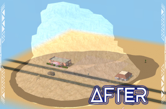
The mega-sized cliff can cover several lots at once. DETAILS Requires all EPs/SPs. §1000 | Build > Architecture | 1230 poly Seamless textures look best since these objects do not use 1:1 scaling and cliffs will NOT go down with walls. ITEMS Desert Cliff 006 (Low, Medium, High, Mega) DOWNLOAD (choose one) Use only ONE of the following versions in-game at a time. VERSION 001 (V1) You’ll need the Rock TXTR Repository from the Repository Pack (Simmons, 2023) – the top/bottom of cliffs can be recolored separately. You’ll find rock, stone, and earthen recolors on this site under the #ts2recolors, #co2recolors, and #co2repopack tags. VERSION 001 (V1) from SFS | from MEGA VERSION 002 (V2) You need the stone couch mesh from the Stone Super Set (Fractured Moonlight, 2017). Cliffs have one subset and pull all textures from the stone couch. VERSION 002 (V2) from SFS | from MEGA *updated 1-26-2024: improved hood visibility (semi-critical). COLLECTION FILE from SFS | from MEGA *collection file includes items from both versions
CREDITS Thanks: Partially inspired by Mediville (@teaaddictyt), Super Stone Set repo suggestion (@catherinetcjd, 2024). Simming and Sketchfab Communities. Sources: Beyno (Korn via BBFonts), EA/Maxis, Stone Super Set (Fractured Moonlight, 2017), Offuturistic Infographic (Freepik), Desert Cliff 6 (WireframeArt, 2021 via Creative Commons Attribution).
76 notes
·
View notes
Text
Hire a Land Surveyor Before Breaking Ground
Before starting any construction project in Australia, hiring a Land Surveyor is not just a wise choice—it’s a crucial step. Whether it’s residential, commercial, or industrial development, accurate land assessment ensures that building plans align with legal boundaries, zoning regulations, and environmental requirements. A professional Land Surveyor provides the expertise needed to avoid costly legal disputes and construction delays.

What Does a Land Surveyor Do?
A Land Surveyor is a licensed professional responsible for determining land boundaries, topography, and property dimensions. Their work forms the foundation for architectural planning, engineering, and site development. Key responsibilities include:
Conducting boundary surveys to define legal property lines
Performing topographic surveys for elevation and landform data
Establishing building locations in compliance with zoning laws
Creating subdivision plans for large developments
Providing detail and contour surveys required for council permits
In Australia, where land development is regulated through strict planning policies, the role of a Land Surveyor becomes even more significant.
Why Hiring a Land Surveyor is Essential Before Construction
1. Preventing Boundary Disputes One of the primary reasons to engage a Land Surveyor is to avoid boundary encroachments. Misjudging property lines can lead to disputes with neighbours or even forced alterations to structures. A certified survey ensures that construction takes place within the correct legal boundaries.
2. Complying With Local Council Requirements Australian councils often require detailed site plans and topographic data before granting development approval. A Land Surveyor provides these necessary documents, ensuring the project meets all regulatory conditions. Without this compliance, building approvals may be delayed or denied.
3. Protecting Property Value and Investment Accurate surveying not only prevents legal complications but also protects the long-term value of the property. Investors and developers rely on precise land data to evaluate project feasibility. Engaging a Land Surveyor provides clarity on land limitations and usable space, reducing financial risks.
4. Assisting in Environmental Planning In certain parts of Australia, especially near coastal or ecologically sensitive areas, environmental regulations dictate how land can be developed. A Land Surveyor helps assess terrain, drainage, and vegetation to ensure projects are environmentally responsible and legally compliant.
When to Hire a Land Surveyor
Engaging a Land Surveyor should happen during the initial planning phase of any construction or land development project. This includes:
Purchasing a new property
Subdividing land for sale or development
Preparing for new building construction
Renovating or extending an existing structure
Resolving land title issues or easement clarifications
Early involvement ensures that all design and development decisions are based on accurate land data, reducing the risk of having to revise plans later in the process.
Choosing a Qualified Land Surveyor in Australia
It is essential to work with a licensed and registered Land Surveyor who has knowledge of local laws and surveying standards. In Australia, professionals must be certified by relevant state boards, such as the Surveyors Board of Queensland or the Surveyors Registration Board of Victoria.
Verify qualifications, ask for previous project experience, and ensure the surveyor uses modern technology such as GPS, total stations, and CAD software for accuracy and efficiency.
Conclusion: Make Land Surveying a Priority
Before a single shovel hits the ground, a thorough land survey can set the tone for the entire development process. From legal compliance and environmental protection to safeguarding investments and preventing disputes, the benefits of hiring a Land Surveyor are substantial.
No construction project in Australia should move forward without this critical step. By prioritising a professional land survey, developers and property owners ensure a strong, compliant foundation for any structure built above it.
0 notes
Text
7 Hidden Gems in China That Are Off the Beaten Path
The images people think of when they hear China are the Great Wall or Terracotta Army. But hidden beyond the well-known places, is all of the treasures in China waiting to be discovered. There is so much more to explore in this diverse and vast country beyond colourful landscapes, untouched villages and ancient cultural sites. If you’re a person who wants to do something different on your travel experience, you’ll find these off the beaten path gems to add to your China Visa itinerary.

Travellers from the Gulf and Oman in particular, should prepare early. First of all, check the latest guidelines & requirements to apply for a China Visa from Oman and make sure you have all the required documents in hand well in advance. These steps are especially important when securing a China Visa for Omanis so as to avoid any last minute delays and ensure your China trip is as smooth and stress free as possible.
Here are the 7 Hidden Gems in China That Are off the Beaten Path
1. Zhangye Danxia Landform – Gansu Province
Zhangye Danxia which translates to Rainbow Mountains, is located in the remote Gansu Province and is a geologic formation of multicolored sandstone. The colors of this unique landscape are so vivid, at sunrise or sunset it’s almost surreal. Unknown to many international tourists, it is becoming popular among photographers and nature lovers. It is easy to explore (thanks to boardwalks and observation decks) and the nearby town of Zhangye provides accommodation and transport.
2. Jiangxi Province – Wuyuan
A picturesque place for its quaint villages, ancient architecture and the bright yellow rapeseed flower fields that bloom in spring, Wuyuan is a place that attracts a lot of attention. It is tucked away in Jiangxi Province and provides a quiet countryside escape where visitors can walk down the quiet lanes, wander over historic bridges and visit the traditional homes. The area is a dream for photographers and history enthusiasts because of its well preserved heritage. There is a charm of each village, with its own customs, local delicious cuisine and warm hospitality from the local people.
3. Fujian Tulou, Fujian Province
The Hakka community built massive circular or rectangular earth buildings, the Fujian Tulou. These centuries’ old structures were built for communal living and defense where multiple families lived in one structure. These rural sites are a step back in time. Some Tulou have modern updates, but many still have the traditional layout and way of life. The locals welcome visitors and many Tulou even provide simple homestays, so you can have a very immersive cultural experience.
4. Xinjiang Region – Kanas Lake
Kanas Lake which is tucked away in the Altai Mountains of Xinjiang, is a hidden jewel with turquoise waters and alpine scenery. The pristine lake which changes color with the seasons, is surrounded by dense forests and snow-capped peaks. Minority communities like Kazakhs and Tuvas also reside there and it is a land of culture and nature. From the pine forests to hiking to just sitting lakeside and enjoying the peaceful views, this place feels so far from China’s big cities.
5. Xiapu Mudflat – Fujian Province
Xiapu Mudflat is a paradise for landscape photographers, it is one of the most beautiful coastal photography scenes in China. It is well known for the soft light, bamboo poles, fishing nets and the daily routines of local fishermen and seaweed farmers and is located in Fujian Province. The mud glistens and the golden light shines on it early mornings here, when the tide is low. An offbeat destination featuring natural beauty, traditional coastal life.
6. Jingdezhen – Jiangxi Province
Jingdezhen, regarded as the "Porcelain Capital of China," has long been the core of excellent ceramics. Ancient kilns, pottery workshops and you can even try your hand at making porcelain yourself. Modern art spaces mix with deep rooted tradition and it becomes a unique stop for culture lovers and creatives alike. Jingdezhen has more than just ceramics, however and lovely parks and markets to browse (or purchase) intricate handmade works.
7. Langmusi – Gansu-Sichuan Border
A small town in the Tibetan area of Gansu and Sichuan Provinces. It’s surrounded by grassy plateaus and dramatic mountain scenery with several active monasteries and a peaceful, spiritual atmosphere. It's the perfect place for slow, mindful travel (scenic hikes, horseback riding, and quiet moments). Along the way you’ll also be immersed in Tibetan culture and hospitality as many locals are monks or herders who warmly welcome visitors with curiosity.
Check out:
London Tour Packages | Madagascar Tour Packages | Malaysia Tour Packages | Maldives Tour Packages | Mauritius Tour Packages | Mexico Tour Packages | Mongolia Tour Packages | Montenegro Tour Packages | Morocco Tour Packages | Nepal Tour Packages | New Zealand Tour Packages | Philippines Tour Packages | Phuket and Krabi Tour Packages | Phuket Tour Packages | Prague Tour Packages | Rajasthan Tour Packages | Romania Tour Packages | Russia Tour Packages | Salalah Oman Tour Packages | Saudi Arabia Tour Packages | Scandinavian Tour Packages
Conclusion
China's hidden gems are a more personal, more authentic way to experience China's culture and natural beauty. Often these are destinations far from the crowds and full of unique stories, landscapes and communities that are overlooked. Through a misty village or at the edge of a remote lake, every place has its own special magic which can’t be found in guidebooks.
Make sure you handle your China Travel Visa way in advance before you start exploring these offbeat treasures. China Visa Requirements from Oman are a must know for your trip to go smoothly from start to finish. Your visa is sorted, your bags are packed and you’re ready for a one of a kind adventure through the lesser known wonders of China.
0 notes
Link
0 notes
Text
Sleek Cantilevered Home Emerges From Landscape
Emerging seamlessly from the undulating hills of Nashtarud Iran, this home by MRK Office and architect Mohammad Reza Kohzadi is less a structure and more a landform. It’s entitled House Under the Hill. With its grassy roof blending into the terrain, it appears as if the earth itself has curled open to reveal a futuristic sanctuary. The result is an architectural gesture so subtle, it feels…
0 notes
Text
https://www.pond5.com?ref=moktadirjafran791
https://www.pond5.com/artist/moktadirjafran791
view my 3d work
Hungary 3D Map With Animation
Stunning 3D rendered map featuring ultra-realistic terrain textures, elevation contours, and natural landforms. This high-detail topographic model includes mountains, valleys, rivers, and forested areas, all rendered with photorealistic textures for maximum visual impact. Ideal for use in GIS presentations, educational materials, video production, architectural visualization, or game environments. Available in high resolution with dramatic lighting and natural color grading to enhance depth and realism.
#3DMap #DigitalDesign #Visualization #3DRender #3Dmap #texturedmap #topographic #elevationmap #realisticmap #digitalterrain #mapbackground #3Dlandscape #geographic #visualization #mapping #highresolution #surfacetexture #abstractmap #terrainmodel
0 notes
Text
Yunnan travel guide
Yunnan is a tourist destination where natural scenery and cultural landscapes complement each other and has many fascinating tourist attractions.
Kunming Stone Forest Scenic Area Location: Located in Shilin Yi Autonomous County, Kunming City, Yunnan Province. Features: The Stone Forest Scenic Area is famous for its karst landforms and has famous scenic spots such as large and small stone forests, long lakes, and Dadieshui Falls. There are many stone peaks here with different shapes, and it is known as "the first wonder in the world" and "Natural Museum of Shaped Landforms". Honor: It is a national 5A-level scenic spot, a world geological park and a national AAAAA-level tourist attraction, and is included in the World Heritage List.
Dali Ancient City Location: Located in the west of Yunnan Province, it is also known as Yeyucheng and Zicheng. History: Founded in the 15th year of Hongwu in the Ming Dynasty (1382), it is an important carrier of Dali's history and culture. Features: There are 14 key cultural relics protection units at or above the municipal level in the ancient city, integrating the architectural and cultural characteristics of Han, Bai, Yi, Tibetan, Naxi and other ethnic groups. Visitors can feel the rich historical and cultural atmosphere and unique ethnic customs here. Honor: It is a national 4A-level scenic spot and one of the first 24 historical and cultural cities in China.
Lijiang Old Town Location: Located in the ancient city district of Lijiang City, Yunnan Province, China, it consists of three parts: Dayan Ancient City (including Black Dragon Pool), Baisha Residential Building Group, and Shuhe Residential Building Group. History: Founded in the late Song Dynasty and early Yuan Dynasty, it has a long history and rich cultural heritage. Features: The streets in the ancient city are built along mountains and rivers, paved with red breccia, and have famous attractions such as Wangu Tower, Mufu, Wufeng Tower, and Black Dragon Pool. Lijiang Old Town is a national AAAAA-level tourist attraction and a world cultural heritage, embodying local history, culture and ethnic customs. Intangible cultural heritage: including the Naxi Remeicai and the Naxi white sand music, etc. These cultural heritages add unique cultural charm to the ancient city of Lijiang.
Jade Dragon Snow Mountain Location: Located in Lijiang City, Yunnan Province. Features: It is famous for its danger, wonder, beauty and elegance, with 13 rolling peaks and magnificent high-altitude glacier landscape. Taking the ropeway up the mountain, you can enjoy the magnificence of the glaciers and the majesty and magnificence of the snow-capped mountains.
Xishuangbanna Tropical Botanical Garden, Chinese Academy of Sciences Location: Located in Mengla County, Xishuangbanna Dai Autonomous Prefecture, Yunnan Province. Features: This is a comprehensive botanical garden displaying exotic flowers and plants. There are tens of thousands of tropical plants collected in the garden. It is a good place to appreciate the wonderful world of tropical plants and increase your knowledge.
Erhai Lake Location: Located in Dali Bai Autonomous Prefecture, Yunnan Province. Features: Erhai Lake is a plateau freshwater lake in Yunnan Province. The water is crystal clear and surrounded by beautiful natural scenery. Riding along the Erhai Lake you can feel the magnificence and tranquility of the lakes and mountains.
0 notes
Text
The Role of Architectural Drawings in Landscape Architecture
Alpha design labFebruary 05, 2025
In the realm of design, architectural drawings serve as the backbone of any project, whether it’s an urban skyscraper, a cozy residence, or an expansive park. While often associated with buildings, these drawings play a crucial role in landscape architecture as well. At Alpha Design Lab-best architecture company in bangalore, we recognize the power of precise, well-structured drawings in shaping outdoor spaces that are both functional and aesthetically pleasing.
The Intersection of Architectural Drawings and Landscape Architecture
Landscape architecture is the art and science of designing outdoor environments, from gardens and parks to large-scale urban developments. Unlike traditional architecture, which primarily focuses on structures, landscape architecture integrates natural elements like vegetation, water features, and landforms with built environments. Architectural drawings are essential in this process, as they help visualize, plan, and execute designs that harmonize with nature.
Types of Architectural Drawings Used in Landscape Architecture
Various types of architectural drawings guide the development of landscape projects. Each serves a specific purpose, from conceptualizing ideas to detailing construction elements.
Site Plans
A site plan provides a top-down view of the entire landscape project, showing property boundaries, existing features, and proposed additions. It includes pathways, vegetation, water bodies, seating areas, and other landscape elements. Site plans are crucial in communicating the overall vision to clients, contractors, and regulatory bodies.
Master Plans
Master plans offer a more comprehensive vision for large-scale landscape projects, integrating multiple site elements into a cohesive design. These drawings often evolve through different stages, incorporating feedback from stakeholders to refine the design.
Concept Sketches
Early in the design process, concept sketches help landscape architects explore ideas and present preliminary layouts. These freehand or digital sketches focus on spatial arrangements, circulation patterns, and potential focal points.
Planting Plans
A planting plan specifies the types, quantities, and placements of plants within the landscape. It ensures that vegetation complements the overall design, taking into account factors like climate, soil conditions, and seasonal changes.
Grading and Drainage Plans
Proper site grading and drainage are critical to preventing erosion, managing stormwater, and ensuring a stable foundation for landscape features. These drawings depict elevation changes, slopes, and drainage solutions that maintain the site’s ecological balance.
Construction Details
For built elements like retaining walls, pergolas, fountains, and walkways, construction details provide precise measurements, materials, and assembly instructions. These technical drawings ensure that elements are constructed correctly and sustainably.
The Importance of Architectural Drawings in Landscape Architecture
1. Visualization and Communication
Architectural drawings translate abstract ideas into tangible plans, helping clients and stakeholders visualize the final outcome. They serve as a universal language between landscape architects, engineers, urban planners, and contractors.
2. Precision and Feasibility
A well-drafted drawing ensures accuracy in execution, reducing the risk of costly mistakes. It considers spatial relationships, material specifications, and environmental constraints to create feasible and sustainable designs.
3. Sustainability and Environmental Integration
Landscape architecture often aims to enhance ecological balance. Through detailed drawings, architects can incorporate green infrastructure, such as rain gardens, bioswales, and permeable pavements, to promote sustainability.
4. Regulatory Compliance
Many landscape projects must adhere to zoning laws, environmental regulations, and accessibility standards. Architectural drawings play a key role in obtaining approvals from local authorities by demonstrating compliance with these guidelines.
5. Project Coordination
Large-scale landscape projects involve multiple disciplines, from horticulture to civil engineering. Drawings act as reference documents that streamline coordination among various teams, ensuring smooth execution.
The Future of Architectural Drawings in Landscape Architecture
With advancements in digital tools and technology, architectural drawings in landscape architecture are evolving. At Alpha Design Lab, we embrace innovations like Building Information Modeling (BIM) and Geographic Information Systems (GIS) to enhance the design and planning process. Digital modeling allows for more accurate simulations, helping designers analyze environmental impacts and optimize layouts before implementation.
Additionally, parametric and generative design tools enable landscape architects to explore complex patterns and responsive landscapes that adapt to changing environmental conditions. These technologies are transforming the way outdoor spaces are conceived and executed.
Conclusion
Architectural drawings are indispensable in landscape architecture, bridging the gap between vision and reality. From conceptual sketches to detailed construction documents, they guide the design, development, and execution of outdoor spaces that are both beautiful and functional. At Alpha Design Lab-best architects in bangalore, we understand the critical role of these drawings in crafting sustainable, well-integrated landscapes that enhance the built environment. As technology advances, so too will the precision and possibilities of landscape architectural drawings, paving the way for more innovative and resilient outdoor spaces.
Report content on this page
#alphadesignlabs#construction company#architecture#architectdesign#bestarchitects#interior designers#best architects in bangalore
0 notes
Text
The Laurel Inner Space
The Laurel Independent Newspaper, October 2024 Issue
Written in stone: Geology in our region
By AGNES PASCO CONATY
Many structures in the District — the monuments and museums, the federal buildings — reveal much of the underlying geological history of this region. Take the Washington Monument, for instance. The marble exterior faces have a number of characteristics, including shades of color, that indicate the stone was sourced from different quarries, including two right here in Maryland. The core of the structure is bluestone gneiss and granite, also quarried in Maryland, while the interior walls are faced with Maine granite. When finished in 1884, this 554-foot-7-inch monument was the tallest structure in the world. It’s the world’s tallest obelisk and predominantly-stone structure to this day.
And right here in Laurel, we can take a geologic walking tour of historical landmarks, too, that might be seen as monuments, of a sort, to our region’s geology: The Montpelier Mansion and St. Mary of the Mills Catholic Church are two good examples of how geology influenced both architecture and construction in earlier eras. Like most of the city’s historic buildings still standing, the mansion and church were constructed of bricks and clay, which were standard materials in the 18th and 19th centuries.
I’m fascinated by these historic examples of local geology, and my fascination prompted me to learn more about the ground my home in West Laurel stands on. What lies beneath its foundation — and even beneath my own feet? To answer these questions, I turned to easy-to-access, reliable sources including the U.S. Geological Survey (pubs.usgs.gov) and the Maryland Geological Survey (mgs.md.gov).
The state’s site has a map showing six distinct but connected landforms, five of which, stretching from the state’s western border east to the Chesapeake Bay and Atlantic, we can explore on foot. (The sixth is the Atlantic Continental Shelf, which is offshore.) Laurel, along with the greater D.C. region, is located along the north-south border between the Piedmont and the Atlantic Coastal Plain, the landform that gives way to the continental shelf.
Rocks found in Maryland’s Piedmont, to our west, are primarily igneous and metamorphic; igneous rocks form from volcanic activity and, with sufficient pressure over time, transform into metamorphic rocks.
The Atlantic Coastal Plain, spreading out to out to the east, has primarily sedimentary rocks (i.e., sandstone, limestone and shale). Sedimentary rocks form when small rock fragments, typically resulting from weathering or erosion, are compressed over thousands of years. Many sedimentary rocks in our area, for instance, have formed from deposits of the Patuxent and Patapsco rivers.
Dinosaur Park, a 22-acre tract under the auspices of the Prince George’s County Department of Parks and Recreation, offers us an unusual geological glimpse into our region’s history. In 1858, African American workers mining iron ore at the site discovered dinosaur fossils, the first ever found in Maryland.
Since those first finds, scientists have discovered hundreds of dinosaur teeth and bones at the site; most are from sauropods (long-necked herbivores), and theropods, which, like the Tyrannosaurus rex, were large predatory carnivores. The majority of these fossils date to the Cretaceous period, which followed the Jurassic period, taking place 145 million to 66 million years ago.
The Maryland-National Capital Park and Planning Commission purchased the tract and established Dinosaur Park in 1995.
And dinosaurs roamed far beyond the bounds of that 22-acre tract, of course. (Indeed, they inhabited most of the Mid-Atlantic region during a period that lasted roughly 158 million years.) I work at NASA/Goddard Space Flight Center, and we have an exhibit (pictured below) of dinosaur artifacts, most of which were found right here in Greenbelt by Ray Stanford, an amateur paleontologist with an extraordinary knack for finding dinosaur tracks.
During excavation of a Goddard parking lot in 2012, Stanford unearthed the footprint of a nodosaur, a heavily armored plant-eating dinosaur from the late Jurassic period, some 145 million years ago. (You can read Stanford’s account of his finds in this article in Nature magazine: tinyurl.com/yuw8p56t). Subsequent excavations at Goddard have uncovered sauropod tracks like those found at Dinosaur Park, as well, and scientists excavating the parking lot also found pterosaur tracks. Not the ancestor of a bird or bat, and not a dinosaur (though on a branch of the same family tree), the pterosaur was the earliest-known vertebrate capable of flight.
My office at Goddard is a few yards from this intriguing exhibit of digs, and sometimes I spend my lunch break looking at a cast of a fossilized dinosaur poo!
If you’re eager to learn about rockhounding, there are clubs you can join to connect with others who share your interests. I can recommend three clubs right here in Maryland: the Maryland Geological Society (mdgeosociety.org/), the Baltimore Mineral Society (tinyurl.com/2hpe3z3h) and the Southern Maryland Rock and Mineral Club (smrmc.org/).
A quick search online will turn up numerous guides to common rocks and minerals, including specimens you may easily find in our area. Rockchasing.com has a particularly good section about Maryland’s rocks and minerals that includes a list of sites where you can find each type. Rockchasing’s Maryland resources are at tinyurl.com/yfrw7d2b.
And one of the very best ways to experience rockhounding is to start in your own backyard (like I did) — you may be surprised what you can find right under your feet! If you live near a creek (like I do), you may find rocks and minerals, maybe even shells, that have been polished as they’ve been tumbled, over time, by moving water.
I encourage you to get a nice journal so you can describe your digs and draw them in detail. And if you catch the rockhounding bug, consider investing in a hand lens and a rock pickaxe, too. It’s never too late to follow your curiosity and dig right in!
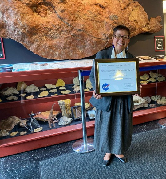
Photo:
Agnes Conaty holding her team’s 2024 Robert H. Goddard Honor Award for Excellence in Outreach in front of the exhibit of dinosaur digs at Goddard Space Flight Center.
Credit: Kristen Weaver
0 notes
Text
EASY PARAMETRIC ROOF STRUCTURE FULL COURSE TUTORIAL | Landform Architecture | Rhino3d | Roof Details
This tutorial course covers a basic parametric landform roof structure design. This courses uses a very basic parameter based on a grasshopper plug-in (see link below). We also cover basic roof details like Insulation, Drainage Boards, Membranes, and Edge Details.
#watercolor#watercolorarchitecture#architecture#architecturediagrams#diagrams#architecturedrawing#rhino3d#3d#archtutorial#adobeillustrator#vectorart#rendering#infographic#graphicdesign#parametric#parametricarchitecture#structure
15 notes
·
View notes
Text
Desert Cliff 007 (Flats)

Published: 1-26-2024 | Updated: N/A SUMMARY Flatter, re-styled versions of Desert Cliff 006 (Simmons, 2024) in FIVE sizes—Low, Low HALF, Medium, High, and Mega. Add a cliff or mix and match several to create unique landforms, visible from both lot and hood view.


DETAILS Requires all EPs/SPs. §1000 | Build > Architecture | 310-596 poly Seamless textures look best since these objects do not use 1:1 scaling and cliffs will NOT go down with walls.
ITEMS Desert Cliff 007 (Low, Low Half, Medium, High, Mega)


I combined 2 Low-Half pieces and the High cliff from Desert Cliff 006 (Simmons, 2024) to build a church in the rocks.
DOWNLOAD (choose one) Use only ONE of the following versions in-game at a time. VERSION 001 (V1) You’ll need the Rock TXTR Repository from the Repository Pack (Simmons, 2023). You’ll find rock, stone, and earthen recolors on this site under the #ts2recolors, #co2recolors, and #co2repopack tags. VERSION 001 (V1) from SFS | from MEGA VERSION 002 (V2) You need the stone couch mesh from the Stone Super Set (Fractured Moonlight, 2017). Cliffs have one subset and pull all textures from the stone couch. VERSION 002 (V2) from SFS | from MEGA

CREDITS Thanks: Simmers – 20 years strong! Simming and Sketchfab Communities. Sources: Beyno (Korn via BBFonts), EA/Maxis, Stone Super Set (Fractured Moonlight, 2017), Offuturistic Infographic (Freepik), Desert Cliff 6 (WireframeArt, 2021 via Creative Commons Attribution).
73 notes
·
View notes
Text
Wings Engine Powers Education: Revolutionizing Virtual Learning Environments
In the field of education and training, traditional teaching methods are gradually combined with modern technology to improve learning efficiency and participation. In Japan, a technologically advanced country, GIS (geographic information system) and 3D scene technology are widely used in education and training to create a more lively and interactive learning environment. These technologies not only enhance the learning experience but also provide effective tools in skill training and field exercises.
Application of 3D scene technology
3D scene technology provides an immersive experience in learning and training by creating a virtual three-dimensional environment. This technology is used to simulate complex systems and processes, allowing students to perform practical operations in a risk-free environment. In skill training, 3D scenes simulate real work environments, such as architectural planning and medical surgery, providing a safe and controllable practice environment.
Applications of GIS technology
GIS technology integrates and processes geographic data, providing powerful spatial analysis tools for education and training. In education, GIS helps students understand geographic distribution, patterns and relationships, deepening their understanding of geography and environmental science. For example, through three-dimensional analysis of GIS, students can explore landforms and topography more intuitively, which is an important element in geography education in junior high schools.
Applications of Wings Engine
Wings Engine is an interactive 3D scene creation platform that brings new perspectives to education and training. It enables complex 3D interactions without coding, making it easy to create and modify educational content. Wings Engine’s real-time rendering capabilities and integration of a wide variety of data make educational simulation environments more realistic and practical.
Practical Examples
In Japan, educational institutions and training facilities are using GIS and 3D scene technology to enhance their teaching effectiveness. For example, Wings Engine can be used by teachers to create interactive geography teaching models, allowing students to learn geography knowledge by operating 3D maps. In addition, Wings Engine can also be used to simulate natural disasters such as earthquakes and tsunamis, training students’ emergency response capabilities.
Summary
The application of GIS and 3D scene technology in the Japanese education and training field shows the potential of these technologies to improve learning outcomes. By creating a more lively and interactive learning environment, these technologies not only increase students’ learning motivation, but also provide effective tools in skill training and field exercises. As technology evolves, the application of GIS and 3D scene technology in the education and training field will become even more widespread in the future, providing stronger support for the development of the next generation of human resources.
0 notes
Text
UPSC Syllabus: An In-Depth Guide for Aspirants
The Union Public Service Commission (UPSC) Civil Services Examination (CSE) is one of India’s most prestigious and challenging exams, with a syllabus that covers a broad spectrum of subjects. Understanding the syllabus thoroughly is crucial for effective preparation. This article provides a comprehensive guide to navigating the UPSC syllabus, offering insights into key areas and practical tips for aspirants.
1. Structure of the UPSC Examination
The UPSC CSE is structured into three stages, each with its own distinct syllabus and format:
Preliminary Examination (Prelims): This stage consists of two objective-type papers:
General Studies Paper I: Focuses on Indian and World Geography, History, Polity, Economy, Environment, and Current Affairs.
General Studies Paper II (CSAT): Tests aptitude skills, including comprehension, logical reasoning, and problem-solving abilities.
Main Examination (Mains): This stage includes nine papers:
Essay Paper: Tests the ability to articulate and develop ideas on a given topic.
General Studies Papers I-IV: Cover History, Geography, Polity, Economy, Environment, and Ethics.
Optional Subject Papers I & II: Focus on a subject chosen by the candidate from a list of optional subjects.
Qualifying Papers: Include one paper each in English and a regional language to test basic language proficiency.
Interview (Personality Test): Assesses the candidate’s suitability for a career in civil services through a face-to-face interaction with a panel.
2. Detailed Breakdown of the Syllabus
General Studies Paper I:
History:
Ancient History: Indus Valley Civilization, Vedic Period, Mauryan Empire, Post-Mauryan Empires.
Medieval History: Delhi Sultanate, Mughal Empire, Regional States.
Modern History: British Expansion, Freedom Struggle, Independence Movement, Post-Independence consolidation.
Geography:
Physical Geography: Earth’s structure, landforms, climate, and vegetation.
Human Geography: Population distribution, migration patterns, urbanization.
Indian Geography: Natural resources, environmental challenges, and regional disparities.
Culture:
Indian Art and Culture including architecture, music, dance, and literature.
Historical monuments and their significance.
General Studies Paper II:
Polity:
Indian Constitution: Framework, Fundamental Rights, Duties, and Directive Principles.
Union and State Government Structure: Powers, responsibilities, and functions.
Judiciary and Legal System: Structure, functions, and significant judicial decisions.
Governance:
E-Governance: Digital initiatives and their impact.
Public Policy and Administration: Key policies, administrative reforms, and governance challenges.
International Relations:
Bilateral Relations: India’s relations with major countries.
Multilateral Organizations: UN, WTO, IMF, World Bank, and their roles.
Global Issues: Climate change, terrorism, and international conflicts.
General Studies Paper III:
Economic Development:
Indian Economy: Economic planning, growth, poverty, and employment.
Budget and Economic Survey: Key highlights and their implications.
Environment:
Ecology and Biodiversity: Conservation efforts, environmental policies.
Climate Change: Impacts and mitigation strategies.
Science and Technology:
Recent Developments: Innovations in space technology, information technology, and their implications for governance.
Science in Everyday Life: Application of scientific principles in daily activities.
General Studies Paper IV:
Ethics:
Ethical Theories: Fundamental ethical concepts and their application in public life.
Case Studies: Real-life scenarios to assess ethical decision-making.
Integrity and Aptitude:
Public Service Values: Role of integrity and accountability in civil services.
Emotional Intelligence: Importance in leadership and administration.
Optional Subjects:
Candidates can choose from a wide range of optional subjects, which often align with their academic background or interests. The syllabus for these subjects is more specialized and requires an in-depth understanding of the chosen field.
3. Practical Tips for Syllabus Mastery
Create a Study Plan: Break down the syllabus into manageable sections and allocate specific times for each topic.
Use Standard Textbooks: Refer to recommended books and materials to cover the syllabus comprehensively.
Regular Revision: Regularly review and revise topics to reinforce learning and ensure retention.
Practice Previous Papers: Solve past question papers and take mock tests to familiarize yourself with the exam pattern and improve time management skills.
Stay Updated: Keep abreast of current affairs and integrate them with your preparation to stay relevant.
4. Conclusion
Mastering the UPSC syllabus requires a strategic approach, meticulous planning, and consistent effort. By understanding the detailed content areas and employing effective study techniques, aspirants can enhance their preparation and improve their chances of success. Remember, the key to excelling in the UPSC examination lies in thorough knowledge, analytical skills, and the ability to apply concepts effectively.
0 notes
Text
10 Aesthetic Concerns When Using Solar Power
More and more people are becoming more interested in utilising solar power in their homes. And if you are the same, there are things you need to know and consider before having them. Some of them are the structural integrity of your roof, cost savings, and the overall safety of the place. However, aside from these, there could also be aesthetic concerns that some people raise. Whether it will affect you or not, here are some aesthetic concerns when using Newcastle solar power:
Panel Visibility
Solar panels are large and can easily be seen. The overall visual appeal of the building or landscape is affected by it, making some people have second thoughts about getting the service. Solar panels can be a mismatch with the building design and disrupt rooflines. If there is full roof coverage, the design of the roof will be seen less.
Colour Matching
Colour matching is also one of the issues of property owners. If it does not match the colour of the roof or the establishment, the entire look of the place changes. Colour mismatch is when dark solar panels are installed on a light-coloured roof, making them very noticeable. There could also be glare and reflectivity issues, especially in certain angles and positions.
Roof Design Compatibility
Before installing panels on the roof, ensure that the roof and solar design is compatible. Consider the roof shape and slope because it can influence visibility and prominence. If the roof shape is irregular, it can affect how the panels will be installed, giving it a disorganised look. For homes with flat roofs, the panel needs to have tilt frames to get the right angle for sunlight exposure.
Integration with Historic Buildings
You will see solar power being used in different establishments. You will see it in homes, offices, and even malls. But if there is one that also gets the advantages of solar energy, it is historic buildings. Some people do not want it because they want the architectural integrity of the place to be preserved.
Panel Reflectivity
Solar panels have reflective surfaces that can create visual issues. There is glare and visual discomfort, not only to the residents but also to the neighbours. For sure, the last thing you would ever want is to receive a complaint. If there is a building adjacent to yours, they could also be victims of the reflection. The visual harmony of the community or the neighbourhood can be negatively affected.
Mounting Hardware Exposure
The overall looks of the place can get the concern of the people because of the solar panel. Mounting hardware exposure is a huge deal because it can cause visual clutter and disruption of clean lines. It can also obscure architectural details and there are visible roof penetrations.
Landscape Disruption
If you have solar panels on the ground and not on the roof, this aesthetic concern is one thing you might face. It impacts the natural views and scenic beauty of the property, disrupting natural landforms. If you have a garden, it can also clash with the design, especially when it comes to planting schemes.
Compatibility with Modern Architecture
Solar panels need to complement modern architecture to ensure that it will not badly affect its overall looks. There should be details like clean lines, minimalist design, and innovative materials. You know that the appearance is ruined if there are mismatched architectural lines and visible hardware. There are also material incompatibility and reflectivity issues that might occur.
Seasonal Appearance Changes
The changing environmental conditions are something you cannot stop. With this, you do not know if the solar panels will complement the looks of the place whenever the season changes. When it comes to vegetation, there could be an impact on deciduous trees and change something on the seasonal growth patterns.
Neighbour Concerns
If your neighbours have had a scenic view before but the solar panels have ruined it, be ready for what they have to say. Not taking the appropriate actions can cause issues and strained relationships with the neighbourhood and the community. Address them properly if you want to continue using solar power.
With all the good things that solar power can provide, you cannot blame the people who are concerned about aesthetics. These concerns are valid and should not be ignored, so think of various options to address them and make sustainable energy usage worth it.
0 notes
Text
The Role of 3D Laser Scanning in Toronto's Environmental Assessments
Toronto, a bustling metropolis known for its architectural landmarks and vibrant urban life, faces unique environmental challenges as it continues to grow and develop. As the city navigates issues such as urban expansion, infrastructure development, and conservation, the need for accurate and efficient environmental assessments becomes increasingly critical. In this context, 3D laser scanning technology has emerged as a transformative tool, offering unparalleled precision and insight that drive more effective environmental assessments and decision-making processes.
Understanding 3D Laser Scanning Technology
3D laser scanning, often referred to as LiDAR (Light Detection and Ranging), is a cutting-edge technology that captures precise three-dimensional data of physical environments using laser beams. The scanner emits laser pulses and measures the time it takes for the pulses to bounce back from surfaces. This data is then used to create highly accurate digital models of the scanned area, which can include everything from intricate architectural details to expansive natural landscapes.
The ability of 3D laser scanning to capture millions of data points with sub-millimeter accuracy makes it an invaluable tool for a range of applications, including environmental assessments. In Toronto, where the interplay between urban development and environmental conservation is a key concern, this technology plays a crucial role in providing detailed, actionable data that supports informed decision-making.
Applications of 3D Laser Scanning in Environmental Assessments
1. Detailed Environmental Mapping
One of the primary applications of 3D laser scanning in environmental assessments is the creation of detailed environmental maps. These maps offer a comprehensive view of the topography, vegetation, and built structures within a given area. In Toronto, this capability is particularly useful for mapping natural landscapes, such as riverbanks, wetlands, and forested areas, as well as urban environments with complex infrastructure.
For example, when assessing a potential site for development, 3D laser scanning provides a precise representation of the existing conditions. This detailed mapping allows environmental scientists and planners to identify features such as floodplains, erosion-prone areas, and sensitive ecosystems. By understanding these features, stakeholders can make better-informed decisions about land use and development, minimizing the impact on the environment.
2. Monitoring Environmental Changes
Environmental monitoring is essential for tracking changes over time and assessing the impact of various activities on ecosystems. 3D laser scanning offers a powerful tool for monitoring environmental changes with high precision. By conducting periodic scans of the same area, it is possible to track alterations in landforms, vegetation cover, and infrastructure.
In Toronto, where urban expansion and infrastructure projects are ongoing, 3D laser scanning helps monitor changes in areas affected by construction or other human activities. For instance, the technology can be used to assess the impact of new developments on nearby natural habitats, ensuring that any adverse effects are identified and addressed promptly. Additionally, 3D laser scanning can monitor the health of green spaces, such as parks and natural reserves, providing valuable data for conservation efforts.
3. Assessing Environmental Impact
Environmental impact assessments (EIAs) are a critical component of planning and regulatory processes for new projects. 3D laser scanning enhances the accuracy and effectiveness of EIAs by providing detailed data on the physical characteristics of the project site and its surroundings.
In Toronto, where the integration of new developments with existing urban and natural environments is crucial, 3D laser scanning enables a thorough evaluation of potential impacts. For example, when planning a new transportation infrastructure project, the technology helps assess how the project will affect local ecosystems, water bodies, and air quality. This comprehensive analysis supports the development of mitigation strategies and ensures that environmental regulations are met.
4. Supporting Conservation and Restoration Efforts
Conservation and restoration projects require precise data to ensure that efforts are targeted and effective. 3D laser scanning provides valuable information for these projects by capturing the current state of natural features and documenting changes over time.
In iscano Toronto, conservation initiatives such as wetland restoration or habitat preservation benefit from the detailed data provided by 3D laser scanning. For instance, when restoring a degraded wetland, accurate mapping of the existing conditions helps guide the design and implementation of restoration activities. The technology also allows for the monitoring of progress, ensuring that restoration goals are met and adjustments are made as needed.
Benefits of 3D Laser Scanning for Environmental Assessments
1. Enhanced Accuracy and Precision
The primary advantage of 3D laser scanning is its ability to capture data with exceptional accuracy and precision. This level of detail is crucial for environmental assessments, where even minor inaccuracies can have significant implications. The high-resolution data provided by 3D laser scanning ensures that environmental features are represented accurately, supporting more reliable analysis and decision-making.
2. Efficient Data Collection
Traditional environmental assessment methods often involve time-consuming field surveys and manual measurements. In contrast, 3D laser scanning enables rapid data collection over large areas, reducing the time and resources required for assessments. This efficiency allows for more frequent monitoring and timely responses to environmental changes or issues.
3. Comprehensive Visualization
The 3D models generated by laser scanning offer a comprehensive visualization of the environment, making it easier to understand complex spatial relationships and features. This visualization supports better communication among stakeholders, including planners, regulators, and the public, by providing clear and detailed representations of the assessed area.
4. Integration with Other Technologies
3D laser scanning data can be integrated with other technologies, such as Geographic Information Systems (GIS) and Building Information Modeling (BIM). This integration enhances the analysis and presentation of environmental data, allowing for more sophisticated evaluations and simulations.
Case Studies: 3D Laser Scanning in Action in Toronto
Several projects in Toronto have demonstrated the impact of 3D laser scanning on environmental assessments:
Waterfront Revitalization: The Toronto Waterfront Revitalization project utilized 3D laser scanning to assess the conditions of existing infrastructure and natural features along the waterfront. The detailed data supported the design and implementation of improvements while preserving the ecological health of the area.
Green Space Conservation: Conservation efforts in Toronto’s parks and natural reserves have benefited from 3D laser scanning’s ability to monitor changes in vegetation and landforms. This data has been instrumental in guiding restoration activities and ensuring the sustainability of green spaces.
Urban Development Projects: Large-scale urban development projects in Toronto have leveraged 3D laser scanning to evaluate potential environmental impacts. The technology has facilitated more accurate assessments of how new developments interact with existing infrastructure and natural environments.
Conclusion
3D laser scanning technology is playing a pivotal role in Toronto’s environmental assessments, offering enhanced accuracy, efficiency, and insight. By providing detailed data on both natural and built environments, this technology supports better decision-making, effective monitoring, and successful conservation efforts. As Toronto continues to evolve, the integration of 3D laser scanning into environmental assessments will be essential for balancing growth with sustainability and ensuring that the city’s development aligns with its environmental goals.
Contact us: iScano Toronto 126 Simcoe Street, Unit 2204, Toronto, Ontario M5H 4E6 (647) 773-1341 https://iscano.com/3d-laser-scanning-toronto/

youtube
#3D Laser Scanning Services Toronto#3d construction scanner#3d scanning services#Laser scanners#laser scanning#3d laser#laser scan#Youtube
0 notes