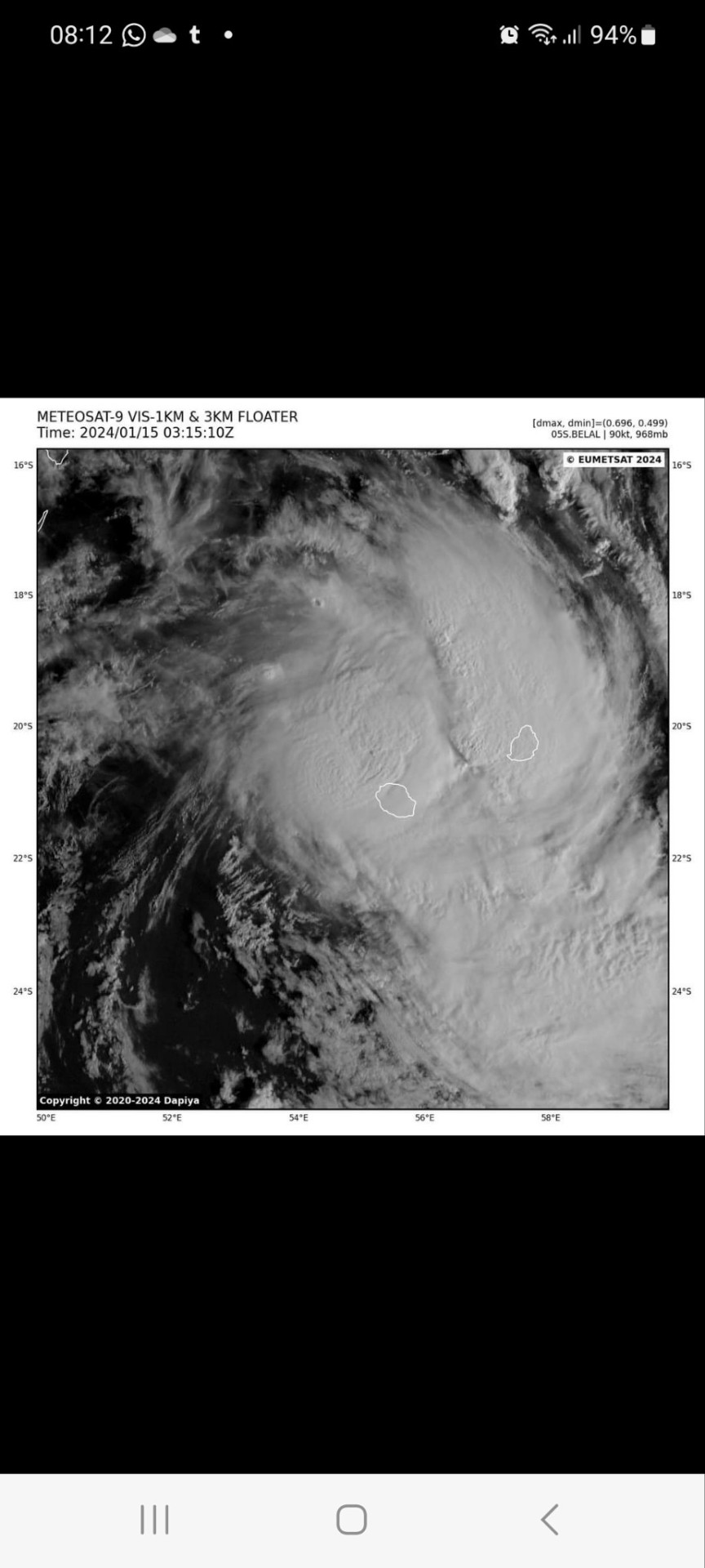
#Tropical Cyclone Damage
Explore tagged Tumblr posts
Visit Tumblr Blog
Explore Tumblr blogs with no restrictions, modern design and the best experience.
Last Seen Tumblr Blogs


Fun Fact
Mobile Tumblr US users spend an average of 4.04 minutes per session on the app.
Text
Global Cyclone Impact: A Detailed Summary
Read to know more about Cyclones- powerful tropical storms, that wreak havoc with high winds and heavy rain. Learn about their formation, intensity, and how they leave a devastating impact on regions worldwide
#Global Cyclone Impact#Cyclone Summary#Cyclone Effects Worldwide#Cyclone Impact Analysis#Tropical Cyclone Damage#Cyclone Preparedness Tips#Cyclone Risk Assessment#Cyclone Frequency and Impact#Climate Change and Cyclones#Cyclone Statistics and Facts#Cyclone-prone Regions#Cyclone Mitigation Strategies#Cyclone Economic Impact#Cyclone Environmental Impact#Cyclone Preparedness Guide
0 notes
Text
Today there is a tropical cyclone where I live. It's very common during this period but, this time it's passing directly upon us and I must say it's pretty scary 😨
2 notes
·
View notes
Text
Rare cyclone weakens to a tropical low weather system as it approaches the Australian east coast - The Times of India
BRISBANE: A tropical cyclone weakened into a tropical low weather system on Saturday as it approached Brisbane, Australia’s third-most populous city, bringing flooding rain that was expected to lash the coastal region for days.Tropical Cyclone Alfred had been expected to become on Saturday the first cyclone to cross the east Australian coast near the Queensland state capital since 1974. But it…
#Australia cyclone news#Brisbane weather#flooding in Queensland#Gold Coast storm damage#missing person in New South Wales#Queensland flooding updates#Queensland Premier David Crisafulli#severe weather warnings#Tropical Cyclone Alfred#tropical low weather system
0 notes
Text
04.10.2025-Story by Marina Wang
In 1992, Hurricane Andrew, one of the most devastating tropical cyclones in U.S. history, ravaged Elliott Key, Florida. “Most of the island was covered in seawater, and about a quarter of the trees were either toppled or completely broken,” says Sarah Steele Cabrera, a biologist at the University of Florida. “There was not a leaf to be seen.”
At the time, conservationists fretted that the enormous hurricane was going to wipe out the last of the island’s Schaus’ swallowtails (Papilio aristodemus), a species of endangered black-and-yellow butterfly native to southern Florida and now found only on Elliott Key and nearby Key Largo. And the butterfly’s numbers on the island did take an initial hit from the storm. But only four years later, much to scientists’ surprise, the population jumped dramatically. Now, a 36-year-long dataset shows that Schaus’ swallowtails saw similar post-hurricane population bumps after two subsequent hurricanes: Wilma in 2005 and Irma in 2017.
In 1976, the Schaus’ swallowtail butterfly became one of the first insects to be listed under the U.S. Endangered Species Act, Cabrera says. This critically endangered butterfly prefers higher-elevation hammock forests with a mix of standing trees and grassland—a habitat that also happens to be prime real estate in the Florida Keys. The butterfly’s numbers on Elliott Key hit an all-time low in 2007, just two years after Hurricane Wilma, with an estimated 56 individuals remaining. But the most recent estimate from 2021 shows the island’s population sitting at a slightly more comfortable 4,400 or so.
While it seems counterintuitive, the dataset suggests that hurricanes are partly responsible for the butterfly’s current spike in population. To make sense of the recurring post-hurricane peaks, Cabrera and colleagues analyzed how butterfly numbers varied with precipitation, wind speed, temperature, and other meteorological variables.
When a hurricane first makes landfall, Cabrera says, the storm’s high winds kill many adult butterflies, while its surges of salty ocean water drown many caterpillars. In the immediate storm’s aftermath, both butterflies and caterpillars have fewer flowers or leaves to feed on. But as the damage fades and the years march on, toppled trees and downed branches create gaps in the canopy that let light penetrate to the forest floor. With more space and light, understory plants flourish, bringing fresh greenery for caterpillars and blooming flowers for butterflies.
“Hurricanes are natural disturbance events that shape population dynamics in ways that we are only just beginning to understand,” Cabrera says.
Jess Zimmerman, an ecologist at the University of Puerto Rico who was not involved in the study, says the nearly four decades of observations that went into this research offer the perspective of a wide-angle lens, yielding much more insight into the butterfly’s long-term crests and troughs than a narrower dataset could provide. As a result, he says, scientists are now more confident that the Schaus’ swallowtail population has remained fairly stable over the long term, despite high year-to-year volatility.
In general, Zimmerman says, animals that evolved in areas prone to disturbance are adapted to handle those variables. Schaus’ swallowtails, like many of the insects that Zimmerman studies, have many offspring and their populations can balloon under the right conditions. “They have ways of making it through these disturbances without getting lost,” he says.
#good news#butterflies#swallowtail butterfly#endangered insects#endangered species#science#environment#environmentalism#nature#animals#conservation#usa#hurricanes#resilience#resiliency#entomology#adaptation#ecology
45 notes
·
View notes
Text
You really should know about Storm "Daniel"
Unlike how much all of us Greek blogs notify our tumblr communities about the regular (at this point) arsons wildfires afflicting Greece, we did not say much about the floods the country has been suffering from right now. There was a mention here and there and I even made a joke post as the storm was starting but not a lot of stuff in general. So, I think there's a couple of things you should know and I feel like I could address about it and actually it's not just about Greece. So I believe this could interest a lot of people and it should be something known worldwide.
In the beginning of September there was an alarm about an extreme weather phenomenon forming above the Ionian Sea at the west of mainland Greece. In truth, the phenomenon was not caused by the climate change. It was just a very rare occurence where a high pressure atmosheric system was sandwiched between two currents of low pressure. Low pressure systems are the ones resposible for stormy weather while high pressure systems generally create stable weather. As the low currents encircled the high pressure system, the storm that had started forming became unusually stable for a storm. As a result, the storm moved northeast above Thessaly and other regions of the central part of Greece and... just decided to stay there for an indefinite amount of time. Furthermore, because it's September and the Ionian Sea had warmed up throughout the summer, the medicane (Mediterranean cyclone) gained tropical features as it was forming, pushing its intensity to extremes unknown to this area.
The storm remained above all of central Greece for about 4-5 days but at the meantime it was causing side-storms in neighbouring countries, such as Bulgaria and Turkey. Both countries suffered from floods causing damages and deaths.
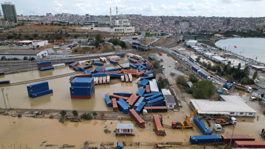
Istanbul, Turkey (CNN).
Tsarevo, Bulgaria (CNN).
Four people died in Bulgaria and seven in Turkey.
But like I told you the core of this was exactly on top of Greece's central mainland and islands. So what happened there? I happened to experience this shit first hand. My recollection of it is that it was unlike any other storm I had experienced before. My knowledge on meteorology is not very advanced, however I believe due to the high pressure part, there were actually no winds at all - or they were insignificant, so it wasn't like what you might have in mind as a conventional cyclone. It was a rainstorm but it was like a rainstorm from hell. The crucial part is that in Greece summer violent rainstorms may last for about five minutes but certainly not for five days nonstop. There was no pause, not even for a second. It kept pouring and pouring in indescribable volumes, without decreasing or slowing down, not for a moment. The fourth day it started taking short breaks.
As a person with a phobia of lightnings since childhood, I kept wearing earplugs throughout all these days. For four days, ten seconds did not pass without at least one lightning shrieking exactly on top of our heads. In the end, I am dead serious, I think my lifelong phobia has been cured somewhat due to this extreme exposure that eventually had a numbing effect. I think only the first day there was a record of 7,000 lightnings. I believe there must have been dozens of thousands overall. The lightnings also caused fires but the downpour was so overwhelming no fire could ever stand a chance.
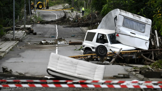
Whether during or after the rains, what I was seeing outside was post-apocalyptic. The only thing missing was the zombies. It really looked like a background from a videogame, including a constantly lit up sky. I was not in danger though people dear to me were. The worst for me was a huge fall in the quality of living but that doesn't matter. The rains caused severe destructions across cities and villages. They caused floods, they broke bridges, they broke a massive number of roads, they made walls collapse, they destroyed springs, they damaged water and electricity outlets entirely, they drowned flocks and flocks of animals, they destroyed mountainous and coastal villages alike, they made cars float and fly over each other and they uprooted houses.

Village in Mount Pelion, Greece.
But that's not the end of it. Four days later, the storm moved southwest towards the Ionian sea, basically to the place of its original formation. It side-swept over Athens in the meantime, flooding the city, but that doesn't mean much since I could cry and Athens would still flood with my tears. Anyway. AFTER the storm left, the floods caused by it started multiplying and expanding. Picture that: a crystal clear sky, a bright sun and your phone screaming state alerts about evacuating your village or town because a lake has launched at you! Here's the thing: Thessaly is a massive plain surrounded by a ring of mountains. Half of those downpours fell right on the lowlands causing floods and destructions the first days. The other half however fell on the mountains, filled the streams heading down and they all met up and filled the lakes and the large river of Thessaly, Pineios and they all basically exploded the next days. Pineios especially exploded both in its western and eastern part, sinking the entirety of Thessaly's plains under water. As a result, floods were actively taking place days after the storm had ended and the weather was good. The phenomena have only started subduing since yesterday.

The overflowing of the river, trapped by the mountains.
Farmers won't be able to work this year and next year is questionable as well. There are huge concerns about various epidemics breaking out as more and more dead animals are found in the waters. Entire villages are under the water. There are estimations that some villages in west Thessaly might have been lost forever and their residents will have to move elsewhere. Sixteen people have died from the rainstorm and the floods.

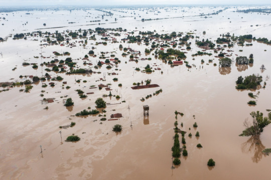
Actual villages in Karditsa, Greece.
A more longterm danger is that the ground received such an unnatural amount of water that it might have been severely eroded and destablised, making it vulnerable to natural disasters I don't want to utter. Many roads are either broken or bloated and Thessaly has been cut out from communication and transportation with the rest of the country. To this day, there are maps guiding people how to drive from North to South Greece and vice versa by entirely skipping Central Greece! (Hint: they will have to drive through Epirus, aka western Greece.) The first days there was also complete isolation from what was happening in the country and the world and also the very regions we were in as we had no electricity and our only chance was getting a call from somebody being elsewhere and telling us what is going on.

Volos, Greece (CNN)
Many regions have received within 2-4 days 55 times their monthly amount of rain or more than twice the yearly amount. Greek meteorologist Christos Zerefos estimated that such a phenomenon occurs every 300-400 years. Meteorologists were alarmed internationally - with Germans and Americans reportedly saying they hadn't studied such a phenomenon again in their career. Its intensity was record high in the history of Greece and right in the top of Europe's as well. They also agreed that such a phenomenon would be devastating even if it had hit the most advanced and prepared country.
BUT THIS IS NOT THE END. The weakened Daniel seemed to slowly move towards South Italy but it decided to take a turn and headed south towards Libya and Egypt. Quite possibly, as the storm was once again travelling across the warm Mediterranean Sea, it was rejuvenated and gained even more tropical traits. Eventually, the medicane hit Libya with unprecedented force.

The cyclone travelling from Greece to Libya.
The toll it took on Libya is unspeakable. As I am writing this,
More than 5,226 people are killed and more than 10,000 are currently missing.
Like, can you wrap your head around what I am talking about? I don't see this shit being acknowledged enough across the world. I am checking this again and again, to ensure I am reading this correctly.
Daniel has officially become the deadliest medicane on record.
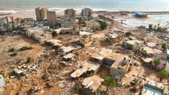
Eastern Libya, from Al Jazeera.
In the meantime, Greeks found opportunities to practice their favourite sport: political infighting. People who weren't even here when hell broke loose say that if this or that was properly done, we would not have problems at all. I even saw an idiotic Greek expat comment how "we got drowned in a little bit of rain". The truth is we should bloody thank our lucky stars and I say this with the entire awareness of half of Thessaly being currently underwater. It is true that Greek governments and people have done so many things badly, like building on top of streams and rivers, changing rivers' natural route, drying up natural lakes and all that shit that guarantees you are going to have massive problems once a serious storm breaks out. Also, the disaster revealed that there was once more a very questionable management of all the money given by the EU for anti-flooding measures after a previous flood (Ianos). Of course, I would be happy if at last we viewed this disaster as an opportunity to improve ourselves and the management of our land, however whatever happened these days wasn't the fault of anyone in particular. On the contrary, A LOT worse could have happened. A lot. Maybe Libya is not an indication because if Greece is not used to such extreme rain phenomena, then Libya is probably ten times less used to them, however we should not forget that this monster was STUCK at least five days over the heartland of Greece. For this alone we should damn be thankful we did not get it any worse and that the land endured in any way and of course now we have to correct old mistakes as well but let's do it united and determined and without wasting time once more in pointless infighting, which in this case might even be unfair. (In fact I think the thing we should blame the state the most about was not making it clear beforehand that this was going to be unprecedented, not just "very severe". They probably didn't want to cause panic and mayhem but still. We should know.) Of course I am not talking about how the state will treat the afflicted regions from now on, which is entirely its responsibility. And we should stand next to Libya. Greece has its wounds to mend but it should absolutely provide support to Libya. We know what this freak phenomenon was like.
I know this text is long but please consider reblogging this. We should know what happens on our planet. Thousands of people are dead from a freak phenomenon devastating regions across lands and seas. Also forgive any mistakes I might have made although I believe the information is correct for the most part. I didn't speak more about Libya because I don't know enough to analyze the situation as much. Perhaps there are ways of supporting the country too. As a last note, this phenomenon was not freakish because of the climate change - it was just a very unusual occurence. However, the - otherwise normal - warmth of the sea did feed and intensify the storm and the climate change might in the future cause these super rare, accidental phenomena to become more frequent.
#greece#libya#weather#climate change#storm#rainstorm#cyclone#flooding#natural disasters#world#tw death mention#world news#europe#africa#turkey#bulgaria#egypt#maps#storm daniel#greek facts#greek news#news#tw long text#tw long post#tw long#signal boost
790 notes
·
View notes
Text
California has gotten its first tropical storm watch ever. The last time a tropical storm hit California was in September of 1939 just after Hitler had started World War II. They didn't issue such watches in those days.
Major Hurricane Hilary in the Pacific is way stronger than low energy Hurricane Don in the Atlantic a few weeks ago; the latter spent only a few hours as a hurricane as it spun around aimlessly away from land.
Hilary will weaken from the current Category 4, but how much it will weaken is still not certain. If it maintains sustained winds of at least 74 MPH/119 KMH when it reaches California, then it will become California's first ever official hurricane.
Hurricane Hilary is expected to hit Southern California as a tropical storm, with a punch that could include flash flooding and significant amounts of rain, according to the National Hurricane Center. A tropical storm watch for much of Southern California was issued Friday morning. The National Weather Service's San Diego outpost said this was the first time such an advisory had ever been issued for the region.
As somebody who's been through half a dozen tropical cyclones on the East Coast, I would advise our California friends that rain is a bigger hazard than wind – in most cases. People in areas which have the potential for flooding should particularly remain on alert.
The 1939 storm, called El Cordonazo, became the first and only tropical storm to make landfall in the state in the 20th century, according to the National Weather Service. NWS says the storm, which was at one point a hurricane, originated off the southern coast of Central America before moving north and eventually coming ashore at San Pedro, California. Resulting floods from the storm killed at least 45 people across the Southern California region and caused $2 million in damage to structures and crops, the weather service reports. Another 48 people were also killed at sea.
There were far fewer people in California in 1939 when El Cordonazo caused deadly flooding.
Here is the current forecast for rainfall potential.
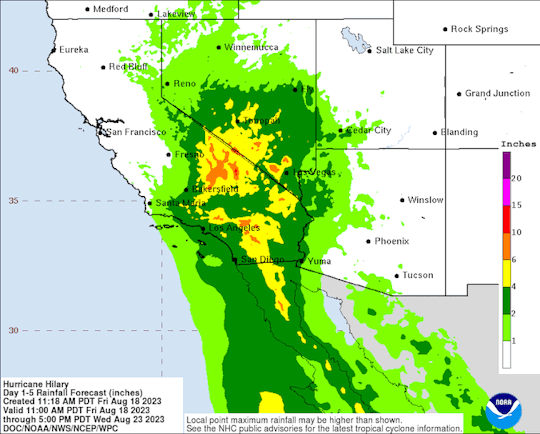
Keep up with the track of Hurricane Hilary here. Southern California should begin to feel the effects of Hilary on Sunday afternoon. Monitor local emergency information and follow advisories.
And if you're wondering why this is happening...
Our oceans are the warmest in recorded history. This is why it's so concerning
#hurricane hilary#california#potential flooding#california's first tropical storm since 1939#climate change#warming oceans#climate disasters
699 notes
·
View notes
Text
milton rapidly intensified from a category 1 to a category 5 hurricane in under 24 hours. it will hopefully SLIGHTLY “weaken” in wind speed before fall due to wind shear, but i don’t like using the word weaken because it’s a major hurricane no matter what and it’s likely not enough to offset catastrophic damage.
tampa bay area has not been directly hit since 1921, the infrastructure may not be adequate. a category 5 tropical cyclone is without exaggeration the most powerful class of storm capable of being produced on planet earth
i’m in sarasota which is right in the crosshairs of hurricane milton. i think i will be safe physically because i am so so so so lucky to live in a building made of solid concrete + hurricane proof glass and i’m not in an evacuation/flood zone. i live on the first floor so if a tree falls on the building it will hit the roof which is the second floor. so i’ll probably bunker in the bathroom which is the safest room in my complex in the center of the building away from windows.

what i’m more worried about is being without power or water for a long time. it’s very hot and humid and without air conditioning florida is swamp-ass swamp-taint sweat hell.
we have a huge stack of water bottles that we copped in preparation for helene and thank god we didnt have to use it. flashlights and batteries, portable chargers, usb powered fan that i can use a car phone charger and a 9-volt battery attached by a little metal spring from a mechanical pen to activate (awesome hack i did back in 2017 with irma), a box of snacks, plenty of weed edibles (for me), wine (for my mom) and we will be feasting on peanut butter and bread.
44 notes
·
View notes
Text
Excerpt from this story from Yale Climate Connections:
fter a spectacular burst of rapid intensification, Hurricane Helene made landfall just east of the mouth of the Aucilla River, about 10 miles west-southwest of Perry, Florida, at about 11:10 p.m. EDT Thursday. Top sustained winds were estimated at 140 mph, making Helene a Category 4 hurricane at landfall. We’ll have much more on Helene’s many impacts—some still unfolding on Friday—in our next Eye in the Storm post.
Helene’s landfall gives the U.S. a record eight Cat 4 or Cat 5 Atlantic hurricane landfalls in the past eight years (2017-2024), seven of them being continental U.S. landfalls. That’s as many Cat 4 and 5 landfalls as occurred in the prior 57 years. The only comparable beating the U.S. has taken from Category 4 and 5 landfalling hurricanes occurred in the six years from 1945 to 1950, when five Category 4 hurricanes hit South Florida.
With the U.S. taking such a beating from extreme hurricanes in recent years, it’s worth reviewing how climate change is contributing to making hurricanes worse.
Climate change makes the strongest hurricanes stronger
As far back as 1987, MIT hurricane scientist Kerry Emanuel theorized that the wind speeds in hurricanes can be expected to increase about 5% for every increase of one degree Celsius (1.8°F) in tropical ocean temperature, assuming that the average wind speed near the surface of the tropical oceans does not change. Computer modeling has found a slightly smaller magnitude (4%) for the increase.
According to NOAA’s Coral Reef Watch, sea surface temperatures along Helene’s path through the western Caribbean and eastern Gulf of Mexico were about 1-2 degrees Celsius (1.8-3.6°F) above the long-term average. Using the theoretical results above, this increase in sea surface temperatures equated to a 50-100% increase in Helene’s destructive power.
Global warming increases hurricane rainfall
One of the more confident predictions we can make for hurricanes in the future is that they will dump more rain. Global warming increases the rate at which ocean water evaporates into the air, and increases the amount of water vapor the atmosphere contains when fully saturated. This result is about 7% more water vapor in saturated air for every 1°C of ocean warming. This increase in atmospheric water vapor can cause a much larger increase in hurricane rainfall than one might surmise, since water vapor retains the heat energy that was required to evaporate the water, and when the water vapor condenses into rain, this latent heat is released. The extra heat helps power the hurricane, making it larger and more intense, allowing it to pull in water vapor from an even larger area and thus dump more rain.
Climate change causes more rapidly intensifying hurricanes
As discussed in detail in our 2020 post, rapidly intensifying hurricanes like Helene, Ida, Michael, Laura, and Harvey that strengthen just before landfall are among the most dangerous storms as they can catch forecasters and populations off guard, risking inadequate evacuation efforts and large casualties. Unfortunately, not only is human-caused climate change making the strongest hurricanes stronger, but it is also making dangerous rapidly intensifying hurricanes like Helene more common.
According to research published in 2019 in Nature Communications, “Recent increases in tropical cyclone intensification rates,” Atlantic hurricanes showed “highly unusual” upward trends in rapid intensification during the period 1982–2009, trends that can be explained only by including human-caused climate change as a contributing cause. The largest change occurred in the strongest 5% of storms: For those, 24-hour intensification rates increased by about 3-4 mph per decade between 1982 and 2009.
Sea level rise increases storm surge damage
Of the six tide gauges with long-term periods of record along the west coast of Florida, Helene set an all-time high water record at three of them (Cedar Key, Clearwater Beach, and St. Petersburg) – in all three cases just before or just after midnight Thursday night – and came in second or third place behind Hurricane Ian of 2022 and Hurricane Irma of 2017 at the other two (Ft. Myers and Naples). Sea level rise made these records easier to set. Sea level rise since 1947 at the St. Petersburg, Fla., tide gauge has been about 3.09 mm per year, or about 0.3 meters (1.0 feet) if extrapolated to a 100-year period (Figure 1). A substantial portion of this sea level rise is the result of human-caused global warming; the global sea level rise since 1900 is estimated to be about 7.5 inches (0.19 meters). Most of this rise has occurred because of melting of glaciers and because water expands when heated. Over the past 10 years, sea level rise has accelerated along the Florida coast, and the rate has been about 7 mm per year (2.3 feet per century) at St. Petersburg. Changes in ocean circulation and wind patterns, with climate change a potential contributing factor, are thought to be the reason for the acceleration.
35 notes
·
View notes
Text
Guys, please keep Queensland, Australia in your thoughts over the next few weeks and especially the next 24-48 hours. Tropical Cyclone Alfred is expected to make landfall late tonight or early tomorrow morning and is already causing damage and destruction as a Category 2 tropical storm off the coast.
It's scary and almost everyone I know has friends or family who will be affected, if not by the storm itself then by the floods and power outages that come along with. I know there is a lot going on in the world right now but it's important to me that people know what's going on. If it behaves as is currently expected it will be the first cyclone to cross QLD's southern coast in about 50 years, so there may be people who haven't dealt with this before toughing it out for the first time.
If you pray, please consider Queensland when you do, and if you don't, please keep them in mind <3 Here's a link to live updates.
#cyclone alfred#cyclone#tropical storm#queensland#wren warbles#qld#australia#natural disaster#floods#nsw#south-east queensland
10 notes
·
View notes
Text
find dining
summary: Rory and Isabel want food; ridiculous conversation and attempted cannibalism ensue.
word count: 800
As a leading expert on expulsion policies, Rory Carmichael can confidently say that Unicorn Academy's suck. That does not mean he has to be happy that Isabel's grand reappearance at the masquerade has led to her monopolising the only sugar cookies at the function that taste like his grandma's. He's a growing dude! Sure, she's a growing dudette who probably deserves this more than he does after learning her lesson about unicorn feelings, but he got thrashed by a tropical cyclone three months ago and you don't see him complaining at all.
"Man, how did you eat them all so fast?" Okay, maybe you see him complaining a little bit, but the girl with the water unicorn inhaling the frosted monstrosities decidedly less healthy than water when she's always going off about peak physical performance and the billion food groups you and your unicorn have to avoid if you want to do a burpee with your pinky is pure insanity, which Rory can usually appreciate if it's not getting in the way of his devouring the worst possible food group for his body.
"Practice makes perfect," Isabel says.
Then Isabel attacks.
She pokes his foot with the tip of her crutch. The actual amount of damage done (a net none) is unimportant. The damage done to Rory's feelings is permanent.
"Yeowch!" Rory yells at the top of his lungs, as he gosh damn should. He debates collapsing on his knees and curling up unborn-baby-style, as is the appropriate reaction to hurting one's toe, but decides against it after remembering Isabel's hurt a lot more than her toe. "Look, I wasn't the most tactical or considerable about the whole broken leg thing, and I'm sorry for everything I've said or done related or unrelated to that, but you can't hog this tray when Ava and Sophia have been saying their vows at the other one for hours. Dance-off for it?"
A deadpan stare. "Not gonna work."
"Ahem. Well, I've won tons of stuff before, so I bet I could beat you in any thing-off you can think of."
A grin. "Yeah? What have you won?"
"The hearts of many adoring fans." He jabs a thumb at the throngs of said adoring fans, all of whom are dancing the night away and none of whom are blinking in his general direction. Even Ms Furi's fallen asleep in her chair, which is almost an insult to Rory's integrity as a prankster/class clown/boy in need of constant attention, but before he can use any of the permanent markers in his pockets, he needs fuel. Or an excuse to lose all his teeth and get grillz. It's getting hard to tell. Must be starvation.
Isabel snorts. "From your dancing? Val says you stepped on her shoes so much she's asking Mama Furi to hire a twelfth personal pedicurist."
Rory scoffs. Redheads. Zero soul. At least that's a number he can count to. "Not just from my dancing."
"Then from what? 'Cause I don't see you doing cardio drills at a cool twelve in the morning."
"I dunno, being myself?" He puts his hands on his hips and tilts his chin up, convinced he's got the achievement to end all achievements. "I won a lifetime supply of Sour Patch Kids after dirt biking into their HQ and inventing blue raspberry."
Isabel claps. Not for the reason he wanted. "That's a snack; problem solved! Nice seeing ya, dude. Hey, River, you gotta try this—"
River opens his mouth for the teeniest, tiniest fraction of a moment before stumbling backwards, neighing and kicking and panicking in a way that usually wouldn't be panic-worthy because he's River, but nope, there is a hairy purple sprinkle crawling up the icing, dragging a pink thing that could be a tongue or something much worse scraping up every teeny, tiny fraction of sugar. Isabel has the good sense to scream loud enough to drown out Rory's whistle notes and the slightly worse sense to throw the food item with a living, moving creature on it all the way up to Mr Tansy's astronomy classroom.
A girl with her hair piled high—oh, duh, one of Valentina's friends—rushes to the scene and catches the cookie. The unicorn crawls to the heel of her palm, and mayhaps an ant could tell you that it looks disappointed, but Rory isn't an ant, so you're straight out of luck. "Oh, drat, I really need someone to look after Smidgen when I go to the bathroom. Thanks for not eating him!"
And so Jacinta disappears into the crowd, nothing more than a blurry personality dressed in a flurry of pink. Rory looks at Isabel. Isabel looks at Rory.
"Swing to the punch bowl?"
"Long as you don't punch me."
Isabel swings at him instead.
#unicorn academy#rory carmichael#isabel armstrong#who have interacted in the show like. thrice#i don’t know why this is so long i just think they have the potential 2 be unserious besties w skewed priorities#my fic
7 notes
·
View notes
Text
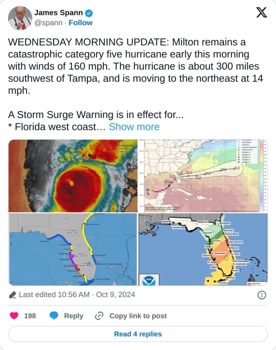
Woo yay yippieeee even :(
From James spann Twitter (above imbed):
WEDNESDAY MORNING UPDATE: Milton remains a catastrophic category five hurricane early this morning with winds of 160 mph. The hurricane is about 300 miles southwest of Tampa, and is moving to the northeast at 14 mph. A Storm Surge Warning is in effect for... * Florida west coast from Flamingo northward to Yankeetown, including Charlotte Harbor and Tampa Bay * Sebastian Inlet Florida to Altamaha Sound Georgia, including the St. Johns River A Hurricane Warning is in effect for... * Florida west coast from Bonita Beach northward to Suwannee River, including Tampa Bay * Florida east coast from the St. Lucie/Martin County Line northward to Ponte Vedra Beach From NHC Milton is moving northeastward at 12 kt in the flow between a mid-to upper-level trough over the northern Gulf and a ridge located over the Greater Antilles. This motion should generally continue until Milton makes landfall in Florida, which is likely to occur late tonight or early tomorrow morning. After the hurricane reaches the coast, a turn to the east-northeast is expected as another trough approaches the system from the west. Milton should exit Florida and move over the Atlantic waters tomorrow afternoon and accelerate eastward after that. The NHC track forecast is nudged a little to the north of the previous one to be in better agreement with the latest models. It should be noted that this forecast is based on the model fields, not the interpolated models which appear to be too far south. Users are urged not to focus on the exact landfall point as the average error at 24 hours is about 40 miles. The global models agree that vertical wind shear is expected begin to increase over Milton later today, and that should cause some weakening. However, there is high confidence that Milton will remain a very dangerous hurricane when it reaches Florida, and maintain hurricane status as it moves across the state. The cyclone is expected to become extratropical over the Atlantic on Friday and gradually weaken. The NHC intensity forecast is similar to the previous one and near the high end of the model guidance. Milton's wind field is expected to grow considerably in size while it moves across Florida. Additionally, a large region of tropical storm and hurricane-force winds could occur on the northwest/back side of the storm since Milton will be interacting with a frontal boundary and beginning extratropical transition. Damaging winds, life-threatening storm surge, and heavy rainfall will extend well outside the forecast cone. This is a very serious situation and residents in Florida should closely follow orders from their local emergency management officials. Evacuations and other preparations should be rushed to completion. Milton has the potential to be one of the most destructive hurricanes on record for west-central Florida. Key messages *A large area of destructive storm surge, with highest inundations of 10 ft or greater, is expected along a portion of the west-central coast of the Florida Peninsula. If you are in the Storm Surge Warning area, this is an extremely life-threatening situation, and you should evacuate as soon as possible if ordered by local officials. *Devastating hurricane-force winds are expected along portions of the west coast of Florida, where a Hurricane Warning is in effect. Milton is forecast to remain a hurricane while it crosses the Florida Peninsula and life-threatening hurricane-force winds, especially in gusts, are expected to spread inland across the peninsula. Preparations to protect life and property, including being ready for long-duration power outages, should be rushed to completion. *Heavy rainfall across the Florida Peninsula through tomorrow brings the risk of catastrophic and life-threatening flash and urban flooding along with moderate to major river flooding, especially in areas where coastal and inland flooding combine to increase the overall flood threat.
Stay safe y'all.
11 notes
·
View notes
Text
A writer’s guide to forests: from the poles to the tropics, part 7
Is it no.7 already? Wow. A big shout out to everyone who has had the patients to stick with this. Now onto this week’s forest…
Dry forest
Water is life. That’s a fact. And especially where it doesn’t rain for more than half the year.
Location: Dry forests are scattered throughout the Yucatán peninsula ,South America, various Pacific islands,Australia, Madagascar, and India. Areas have been cleared by human activity, and the SA dry forests are classified as the most threatened tropical forests.
Climate: Temperate to tropical, with just enough rain to sustain trees. Many are monsoonal, with rain coming in one or two brief periods separated by a long dry season.
Plant life- Hardy trees, such as Baobab and Eucalyptus are able to last with little rain by tapping into groundwater with extensive root systems. Many trees are evergreen, but in India, many species are deciduous. Trees are often more spaced out, and shrubs and grasses grow extensively. Cacti are common plants in the Americas, with some growing tall enough to be considered trees. In order to survive the heat and lack of water, many small plants are annuals, or store water in tubers. Palms can make up a large percentage of the trees, as was the case in the now vanished forests of Easter Island.
Animal life- As they can come and go when they please, birds are common species. Larger animals are active year round, with smaller species of mammals, amphibians, and certain insects only coming out during the rainy season. Isolation means that islands become home to many endemic species; think about Madagascar and the lemurs, or Darwin’s finches, iguanas, and tortoises in the Galapagos. Isolation has also led to the marsupials of Australia developing to fill the niches that would normally be occupied by placental mammals .The introduction of invasive species has brought about the extinction of island fauna.
How the forest affects the story- Water, or the lack of will be the biggest challenge your characters will face. Rivers and lakes may be seasonal, so other sources will have to be utilized. Drinkable fluids can be obtained from various plants and animals, or maybe the bedrock is porous and water accumulates in cenotes. Your characters could come from a culture that builds artificial reservoirs to collect the rain and store it for the dry season. With careful water management, cities can thrive in dry areas. But your characters will have to be careful. Prolonged drought will see societies go the way of the Maya. Deforestation leaves the topsoil vulnerable to the wind, and forests, farms, and grassland will inevitably turn to desert. Whether nomadic or sedentary, your characters and their society will have to find a way to interact with the forest without destroying it or themselves. Can they do it? Can a damaged biosphere be restored before it’s too late? The success or failure of your characters and/or their predecessors can be a driving focus of the plot. Of course ,when the rains do come, it could be in the form of a cyclone. Dry ground does not readily absorb water, and flash floods are a danger. Water can grant life, but it can take it as well.
#writing#creative writing#writing guide#writing inspiration#writing prompts#writer#writers#writing community#writer on tumblr#writeblr
47 notes
·
View notes
Text
Record temperatures last year pushed the global water cycle to “new climatic extremes,” according to the Global Water Monitor 2024 report. The document, produced by an international consortium led by researchers at Australian National University, states that these climatic anomalies caused devastating floods and droughts that resulted in more than 8,700 deaths, the displacement of 40 million people, and economic losses exceeding $550 billion.
The report was conducted by an international team and was led by ANU professor Albert van Dijk. It reveals that 2024 was the warmest year so far for nearly 4 billion people in 111 countries, and that air temperatures over the Earth’s surface were 1.2 degrees Celsius higher than documented at the beginning of the century and 2.2 degrees Celsius higher than at the start of the Industrial Revolution.
Van Dijk asserts that water systems around the globe were affected. “From historic droughts to catastrophic floods, these severe climate variations affect lives, livelihoods, and entire ecosystems. Water is our most important resource, and its extreme conditions are among the greatest threats we face,” he says.
The report authors analyzed data from thousands of ground and satellite stations that collect near real-time information on critical water variables, including rainfall intensity and frequency, soil moisture, and flooding.
“We found rainfall records are being broken with increasing regularity. For example, record-high monthly rainfall totals were achieved 27 percent more frequently in 2024 than at the start of this century, whereas daily rainfall records were achieved 52 percent more frequently. Record lows were 38 percent more frequent, so we are seeing worse extremes on both sides,” says Van Dijk.
The research states that, as a consequence, sea-surface temperatures rose, intensifying tropical cyclones and droughts in the Amazon basin and southern Africa. Global warming favored the formation of slower-moving storms in Europe, Asia, and Brazil, subjecting some regions—such as Valencia in Spain—to extremely high levels of rain. Widespread flash floods occurred in Afghanistan and Pakistan, while rising levels in the Yangtze and Pearl rivers in southern China damaged rice crops.
“In Bangladesh, heavy monsoon rains and the release of water from dams affected more than 5.8 million people, and at least 1 million tons of rice were wiped out. In the Amazon basin, forest fires triggered by the hot, dry weather devastated more than 52,000 square kilometers in September alone, releasing huge amounts of greenhouse gases,” Van Dijk says.
The study adds that changes in the water cycle intensified food shortages, impaired shipping routes, and disrupted hydropower generation in some regions. “We need to prepare for and adapt to inevitably more severe extreme events. That may mean adopting stronger flood defenses, developing new food production systems and more drought-resistant water supply networks,” suggests Van Dijk.
World leaders have pledged to implement measures and policies to prevent global warming from exceeding 1.5 degrees Celsius above preindustrial levels by the end of the century, but the World Meteorological Organization has pointed out that current efforts are insufficient. The WMO estimates that there is an 80 percent chance that the average global temperature will exceed 1.5 degrees Celsius above preindustrial levels again in at least one of the next five years. The projection suggests that humanity is far from meeting the goals of the Paris Agreement and raises new concerns about the progress of climate change.
Securing financial resources is another challenge. The United Nations Environment Program estimates that the funding gap for climate change adaptation is between $194 billion and $366 billion annually.
António Guterres, secretary general of the United Nations, has said that “we are teetering on a planetary tightrope. Either leaders close the emissions gap or we are hurtling towards climate disaster, with the poorest and most vulnerable suffering the most. The countdown to action has begun.”
6 notes
·
View notes
Text
Olivia Little at MMFA:
TikTok users are asking Amazon’s Alexa unanswerable questions about the outcome of rapidly strengthening Hurricane Milton, which is forecast to make landfall in Florida on Wednesday. Unfortunately, Alexa is providing users with inaccurate answers, sparking panic and conspiracy theories that have already garnered over a million views on TikTok. Users are asking variations of the same question: “Alexa, what kind of hurricane was Hurricane Milton?”
“From fandom.com: Hurricane Milton was an extremely powerful Category 5 hurricane that caused widespread damage across its path in October 2024,” responded Alexa in multiple videos. (Although Media Matters couldn’t replicate the response, Alexa did tell us the death toll and monetary damages of a hurricane that has not yet made landfall when we asked if there were any fatalities from Hurricane Milton). Alexa’s response cites fandom.com, a fan-generated entertainment and gaming platform. Within fandom is the Hypothetical Hurricanes Wiki, a “wiki-based comprehensive database of hypothetical tropical cyclone articles that anyone can edit.” One user ends the video by shaking his head and saying, “They’ve already predicted the outcome, I wonder why?” That video has over 738,300 views.
An Amazon Alexa error is causing conspiracy theories about Hurricane Milton to percolate. This is on top of Hurricane Helene-related conspiracies that have popped up.
#Alexa#Amazon Alexa#Amazon#TikTok#Hurricanes#Misinformation#Hurricane Milton#Hypothetical Hurricanes Wiki#Fandom.com
12 notes
·
View notes
Note
This entire situation has caused me to do a lot of research into tropical revolving storms, and basically even though the Sam-Simpson scale ranks hurricanes, it doesn’t account for destruction. You could get massively powerful Category 5 hurricanes but the damage they do is moderate. And on the flip side you have this, Helene was only a Category 4 and when she bursted into North Caroline she was downgraded to a tropical storm but still the sheer amount of damage and devastation…
And yes this isn’t a time for jokes, people have died, rendered homeless and some have lost everything, our hearts need to be with them now. This is also why we need to combat climate change because the reason storms have being getting worse is because of the rising temperatures, which means warmer waters, which means more intense storms.
But in the end this whole situation shows, while we humans like to think of ourselves as masters of the planet, nature still finds ways to humble us.
Super glad to hear from you, and take all the time you need to recover. However since you need some light relief, how about you look up what tropical revolving storms are called in Australia? It’s would be the perfect way to unwind - Review Anon
//Yeah, I used to watch disaster documentaries all the time when I was younger. There's something genuinely morbidly fascinating about the way they happen and the damage they can do. One of my favorites as a kid was Planet Storm, which transplanted extreme weather from Mars, Jupiter and the Sun to Earth.
//I've been going through my asks and it seems some thought I'd vanished for a couple days because i hated the latest episode of Despair Time so much. Which, again, would be funny if people hadn't actually died. I spent days listening to people on the radio looking for missing family. I sincerely don't want to joke about this situation, because it really is that awful. I get jumpy whenever I hear my walls creak now.
//Remember, just because a storm is smaller doesn't mean it's automatically weaker. I heard someone call this the Katrina of the Mountains, but at least disaster management around here hasn't turned into a mess.
//But I'm okay. We've got food, running water and should hopefully have power restored soon.
//Also...no way. There is no way they call cyclones "willy-willies" down under. I love that : P
7 notes
·
View notes
Text
Hurricane Helene was not the first tropical cyclone to hit Georgia. But it entered the state through Georgia's land border with Florida, still at hurricane strength, and retained its tropical characteristics all the way through the middle of the state until exiting at the border with North Carolina and Tennessee.
Helene was one of the increasing number of tropical cyclones experiencing rapid intensification. And it also moved more rapidly than usual for a storm of this type at such latitudes. What people in Florida, Georgia, the Carolinas, and Tennessee experienced with Helene may be a taste of our climate future.
Helene reminded many Georgia voters, especially younger voters, that climate is an issue which needs to be addressed.
In 2020, Donald Trump lost Georgia to Joe Biden by 11,779 votes out of nearly 5 million cast in the state, one of the closest races in that election. Since that time, the Peach State has seen an increase in extreme heat days, rising sea levels and frost damage to crops. And the electorate has grown more concerned about climate change — with 76% of registered voters now supporting congressional action on climate. This time around, with voters in the battleground state closely divided between Trump and Vice President Kamala Harris, climate activists are determined to make sure that their concerns help swing the election to Harris, whose policies are seen as more climate-friendly than those of the former president. Almost half a million voters in Georgia who have expressed concerns about climate change but have not voted in the last two election cycles are now being targeted by the Environmental Voter Project. The overwhelming majority of the voters in this group (88%) are between the ages of 18 and 34 and almost half are Black. Of all the states, “Georgia has the largest number of low-propensity climate voters,” said Nathanie Stinnett, director and founder of EVP, which is nonpartisan but because of its climate focus tends to mobilize more Democratic voters. The group has been targeting young voters in the state with door-to-door canvassing, phone calls, direct mail and social media. According to EVP’s polling, 40% of young voters in five battleground states including Georgia will only support candidates who prioritize climate change — it’s a “deal breaker” for them. And an additional 40% of them said they’d prefer candidates who make it a priority to address climate change. “Young voters are seeing the increases in extreme weather events in Georgia and their rising power bills driven in large part by fossil fuel costs, and noting the need for greater investment in climate technology and solar,” said Marqus Cole, the director of church engagement and outreach for the Evangelical Environmental Network and a former political candidate.
Voters in climate sensitive states need to hear more about climate-denying Donald Trump's coziness with fossil fuel companies. While the increasingly demented Trump often has trouble putting a sentence together, he has no difficulty reciting his favorite mantra, "DRILL! DRILL! DRILL!"

#climate change#hurricane helene#georgia#tropical cyclones#environmental voter project#kamala harris#the environment#evangelical environmental network#fossil fuels#climate deniers#donald trump#drill! drill! drill!#big oil#republicans#election 2024#vote blue no matter who
9 notes
·
View notes