#geospatialAI
Explore tagged Tumblr posts
Text
Niantic is building a ‘geospatial’ AI model based on Pokémon Go player data
Scans of the world from Pokemon Go and Ingress are the backbone of Niantic’s AI model, which aims to navigate the world like ChatGPT spits out text.

youtube
#Tumblr#PokemonGo#Niantic#GeospatialAI#AugmentedReality#DataPrivacy#GamingNews#ArtificialIntelligence#SpatialIntelligence#VPS#MobileGaming#ARTechnology#Youtube
2 notes
·
View notes
Text

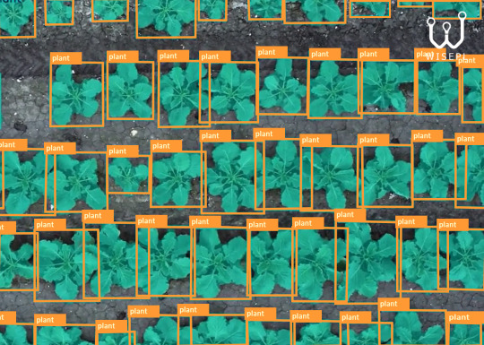
Teaching Machines to See the Harvest Before It Grows
In the age of smart farming, machines need more than sensors - they need vision. We empower agricultural AI with precision-labeled data built specifically for crop detection.
From drone images to satellite scans, our expert annotators craft pixel-perfect polygons, segmentations, and object tags that help models:
-> Detect crop types -> Monitor growth stages -> Analyze field health -> Predict yield patterns
Just clean, human-verified data that turns raw footage into actionable insight for next-gen agri-tech.
Build smarter agri-AI with us. Let’s annotate the future of farming - one pixel at a time. DM us or visit www.wisepl.com to get started.
#cropdetection#smartfarming#AgriTech#AIinAgriculture#WiseplAI#dataannotation#precisionfarming#satelliteimagery#machinelearning#geospatialAI#MLTrainingData#AgriAI#datalabeling#Wisepl
0 notes
Text
youtube
Geospatial AI | Webinar by Dr. Anupam Sobti
As artificial intelligence becomes popular, it offers an opportunity to tackle more problems – whether it’s information about the historical produce of a farm or the declining condition of a road. In Plaksha's flagship i2i webinar series, Dr. Anupam Sobti shared examples and opportunities where machine learning-based perception systems are being (or could be) used to provide economical and reliable information to the right users at the right time to address many challenges that arise in these socio-technical systems.
He also discussed how these ‘sentients’ could enthuse efficiency in data-driven decision-making for policymakers and operational pipelines.
#iotatoinfinity#i2iwebinars#plakshauniversity#faculty#reimagineteched#creatorsfirst#dranupam#artificialintelligence#geospatialai#engineering#newkindofengineer#datadrivendecisionmaking#plaksha university#btech#tech leaders fellowship program#Youtube
0 notes
Text
Smart Seismic Monitoring Market Forecasted to Hit $9.8B by 2034, Expanding at 8.8% CAGR
Smart Seismic Monitoring Market is transforming earthquake detection, structural health monitoring, and disaster preparedness using AI, IoT, and edge computing. Traditional seismic systems often struggle with real-time processing and accuracy, but AI-driven models can now analyze seismic wave patterns instantly, improving early warning systems and risk assessment.
To Request Sample Report: https://www.globalinsightservices.com/request-sample/?id=GIS11117 &utm_source=SnehaPatil&utm_medium=Article
IoT-enabled seismic sensors continuously collect high-resolution data from fault zones, buildings, and critical infrastructure. These sensors transmit data to cloud-based platforms, where machine learning algorithms detect anomalies, predict aftershocks, and optimize emergency response strategies. Edge computing ensures real-time processing even in remote or disaster-prone areas, reducing latency and improving data accuracy.
With 5G connectivity, seismic networks can transmit massive datasets faster, enhancing geospatial mapping and predictive analytics. Integration with digital twins allows engineers to simulate earthquake scenarios, strengthening infrastructure resilience. As urbanization and climate change intensify seismic risks, the global adoption of smart seismic monitoring solutions will be crucial for public safety, risk mitigation, and infrastructure longevity.
#smartseismicmonitoring #aiinseismic #earthquakeprediction #iotforseismic #realtimemonitoring #seismicdataanalytics #earlywarningsystems #geospatialai #earthquakedetection #structuralhealthmonitoring #machinelearningseismology #digitaltwins #predictiveanalytics #smartdisastermanagement #cloudbasedmonitoring #seismicinfrastructure #deepseismiclearning #aiinriskassessment #geotechnicalengineering #smartcityresilience #5gforseismic #sensorfusion #earthquakeresilience #disasterresponseai #edgecomputing #bigdataseismology #climatechangeimpact #autonomousseismicmonitoring #urbanseismicresilience #nextgenseismictech
0 notes
Text

Precision Annotations for Every Aircraft
Airplanes aren’t just flying objects - they’re data points in motion.
We transform raw aerial and satellite imagery into structured intelligence with high-precision airplane detection annotation. Whether it’s for defense analytics, aviation mapping, or geospatial AI - our annotations fuel the accuracy your model needs to soar.
From runway parking to mid-air flight paths, we label it all:
Bounding Boxes
Segmentation Masks
Object Tracking
Altitude & Pose Estimation (custom tagging)
Your model deserves more than automation - it deserves insight.
Let’s power your vision with pixel-perfect precision. DM us or email [email protected] to get a free sample annotation trial. Collaborate with a human-in-the-loop annotation team that gets aerospace.
#AirplaneDetection#GeospatialAI#DataAnnotation#WiseplAI#AerospaceTech#AIAnnotationExperts#SatelliteImagery#DefenseAI#MachineLearningData#AIDetectionServices#AIAnnotation#AirplaneAI#Wisepl#DataLabeling#SatelliteAI#ObjectDetection#AerospaceData#MLTraining#AirTrafficAI#AIForGood
0 notes
Text

High-quality rooftop labeling for geospatial dataset
We deliver precise, scalable, and reliable rooftop data annotation services that power next-gen AI applications — from smart city infrastructure to solar tech and urban planning.
Our experienced team ensures:
Accurate polygon labeling
Rapid turnaround at scale
Enterprise-grade QA
Secure, NDA-bound operations
Working with startups, government projects, and enterprise clients alike - we help you focus on innovation while we take care of the data.
Let’s build smarter systems, together - one rooftop at a time.
Message us or email at [email protected] to learn more. www.wisepl.com
#DataAnnotation#GeospatialAI#UrbanMapping#SmartCity#RooftopLabeling#ImageAnnotation#AITraining#SatelliteImagery#ComputerVision#StartupIndia#GIS#RemoteSensing#AIForGood#Wisepl#MachineLearning#AI
0 notes