#laramide
Explore tagged Tumblr posts
Visit Tumblr Blog
Explore Tumblr blogs with no restrictions, modern design and the best experience.
Last Seen Tumblr Blogs


Fun Fact
Post activity is at the highest at 4:00 pm EDT; notes peak at 10:00 pm EDT.
Text
really really liked The Last of Us so banging out a lore note about my own fatal fungal infection affecting humans but instead of murdery zombies it's "infected victims spend a few days comatose before retreating to someplace high and humid to die in relative (to TLoU) peace and release spores from their ravaged flesh"
"Laramide Jungle Plague" as I'm calling it rn hits mammals hard because it's evolved for warm environments. it has a harder time infecting dinosaurs (which in universe are called Lacertines) because of their mesothermic nature and general Bigness just making them harder to infect.
#science fiction#worldbuilding#the last of us#dinosaurs#disease#fungi#cordyceps#laramide jungle plague#lacertines
6 notes
·
View notes
Text

This is a larger image of the newest rough-draft map for the geology and mountain ranges of Jom'Gol !! Here you can see it with better detail (pls look at my last two posts for more information), where the darkest regions indicate the highest terrain, and the lighter ones indicate lower terrain.
By now you should recognize some of what I've been talking about in my previous two posts-- old mountain ranges have eroded into bluffs or small highlands, while new mountain ranges have developed into very large active orogenous zones. You may also notice the very strange geography going on where some older mountain ranges intersect with newer mountain-building zones, forming very interesting rock formations in the world. Lifting up the old cores of mountains into new higher formations is sure to be interesting worldbuilding-wise, once I get to biomes and precipitation and later on culture and exploration !!
Some other interesting formations include older Appalachian-like mountains being split in half due to faults in the south (Olivine Mts.), and a shallow-plate Laramide/Rocky Mtn. -like formation cutting across the center of the continent. This one is sure to create some interesting geology--and later on, climate zones-- for here we see examples of Basin-Range like crustal stretching (Diamond Mts.), uplifts of old mountain ranges (Black Opal, Flint, Zircon Mts.) and huge plateau drops (Sapphire Range).
There also is a lot going on with the Himalayan-like Quartz group Mts. converging together into a massive plateau larger than the width of North America, while also compressing ancient oceans into solitary seas within the plateau (Quartz, Rose Quartz, Smoky Quartz, Amethyst, old Galena, Chrysoberyl, and Tourmaline Oriental Mts. form this huge amalgam of old and new mountains within the plateau).
These are just some of the examples of cool geological features in the new mountain-rich world! Here is an image of the old Jom'Gol map for a rough comparison. Stay tuned for the new additions when I start digitally making this map AND for more tree of life stuff!

and as I attach this image of the old map, it begins to set in JUST how painful redoing all of it is going to be oh my Lord
#art#artists on tumblr#worldbuilding#jomgol#spec bio#spec evo#speculative biology#speculative evolution#speculative worldbuilding#is spec geo a thing ?#geology#geography#dnd maps#fantasy map#fantasy maps#mapmaking#maps#world building
18 notes
·
View notes
Text


Gap Lake, AB (No. 1)
Mount McGillivray is a 2,451-metre (8,041-foot) mountain summit located in the Bow Valley of Kananaskis Country in the Canadian Rockies of Alberta, Canada. Its nearest higher peak is Skogan Peak, 3.0 km (1.9 mi) to the southeast. Mount McGillivray is a landmark that can be seen from Highway 1, the Trans-Canada Highway in the Exshaw area.
Mount McGillivray is composed of sedimentary rock laid down during the Precambrian to Jurassic periods. Formed in shallow seas, this sedimentary rock was pushed east and over the top of younger rock during the Laramide orogeny.
Source: Wikipedia
#Gap Lake#Mount McGillivray#Bow Valley#Kananaskis Country#travel#original photography#vacation#tourist attraction#landmark#landscape#countryside#Rocky Mountains#Canada#summer 2024#Alberta's Rockies#Canadian Rockies#flora#nature#forest#woods
20 notes
·
View notes
Text
I love how terms from college are still stored in my brain even if I don't use them regularly.
I'll just be going about my day and then randomly remember that the Laramide orogeny during the Cretaceous was what resulted in the formation of the Rocky Mountains.
#geologically speaking the Rockies are babies#practically popped up yesterday!#anyways it's Geology Hours rn#....shit dude if anyone reading this wants to ask me a geology question#even if it's just like ''what is the best rock''#I'm down for some asks#it's been a while since I exercised those parts of my brain#don't want to lose all the stuff I learned lmao#speecher speaks
10 notes
·
View notes
Text
Ok. I am a writer, geologist, and a fan of Tolkien so let's do this.
In some fantasy settings, some things that do not make geological sense can be explained with magic. Ered Lithui and Ephel Duath, the mountain ranges that surround Mordor on three sides, came about as part of the aftermath of the War of Wrath. This War had several Maiar and Valar, including Morgoth (also known at Melkor) and Eonwe.
Both the Maiar and Valar are powerful beings. Valar, such as Morgoth, helped in the shaping of the world with Morgoth actually being the root cause of basically all the problems in Middle Earth because he's a rebellious little shit. The Maiar were created to help the Valar and, while not as powerful as the Valar, are very powerful in their own right. (For example, Gandalf, Sauron, and Sauromon are all Maiar)
Because the War of Wrath involved such powerful beings, it shaped the land around them dramatically. The Blue Mountains in the west were almost entirely sunken beneath the sea and Ered Lithui and Ephel Duath were raised. Mount Doom is also a result of Melkor's work as he created the volcano in the First Age. He did this a few times, forming 3 volcanos in the Iron Mountains as chimneys for his forges.
Does it make geological or geographical sense? No. But does it make canonical sense? Yeah kinda. I'm probably missing a few details, but sometimes, as much as we might like it to be otherwise. the answer simply is 'magic bullshit'.
Now, the Misty Mountains rain shadow.
I'll be honest when I say I don't know as much about rain shadows. But I can do math so let's see how this shakes out.
First, the Misty Mountains are about 1,280 km long. Taking this number and measuring how long and wide the Misty Mountains are on a map (which I got as 6.75 and .5 inches respectively) we can calculate for the approximate width of the Misty Mountains. Which comes out to about 95 km or 59 miles wide. Does this number help? I'm not really sure. But let's compare it to the Rockies.
The Rocky Mountains are about 3,000 miles (~4,8000 km) long. Along with other ranges like the Sierra Nevadas, they basically make the majority of the west coast of North America mountains. This is because of the Laramide orogeny causing uplift much farther inland than a normal orogenic event due to the subducting plate leveling out before subducting again further inland. The Rockies are a huge mountain range, being hundreds of miles wide in some places. They are much larger than the Misty Mountains and cast a much larger rain shadow.
The Appalachian Mountains are smaller and have a very small rain shadow. This is predominantly because they're ancient mountains and have been largely weathered away. The Misty Mountains are likely taller than the Appalachians. But these do have deciduous forests basically covering and surrounding them.
The last mountain range I'll draw for comparison is the Andes Mountains. The Andes range from 200 to 400 km wide. Their average height is around 4,000 meters, about twice the average height of the Rockies. And their rain shadow is much smaller than the Rockies. Forests butt right up to the Andes in some places. The Amazon is just east of part of the Andes.
All of these things taken into consideration, I don't think that Mirkwood being where it is is super unrealistic. Mirkwood doesn't but right up against the foot of the Misty Mountains. There isn't much description of the land between the Misty Mountains and Mirkwood in The Hobbit, but what description we are given is of rolling grasslands with some trees along the River Anduin which flows through it.
Now, I could be wrong about the rain shadow and Mirkwood as I am a geologist and this is not my area of expertise. But those are my thoughts. Hopefully, they make at least some sense.
reminder to worldbuilders: don't get caught up in things that aren't important to the story you're writing, like plot and characters! instead, try to focus on what readers actually care about: detailed plate tectonics
#lord of the rings#the hobbit#middle earth#geology#mountains#science#misty mountains#mirkwood#mordor#feel free to fact check my stuff#i am not infallible#but i do know my rocks
147K notes
·
View notes
Text
总理面临压力要求解除铀矿禁令
Crisafulli政府正面临来自资源行业和保守派前领导人的双重压力,要求解除昆士兰州铀矿开采禁令以创造就业并缓解不断攀升的州债务。 加拿大矿业公司Laramide Resources表示,其位于该州西北部的露天矿场项目已准备就绪,预计每年可为该行业带来超6亿澳元收入,而整个产业每年将为昆州经济贡献数十亿澳元。 自由国家党州长David Crisafulli拒绝撤销禁令,这使其与联邦联盟党在核能政策上的分歧进一步扩大。 昆士兰最后一座铀矿Mary Kathleen于1982年停产。 昆士兰最后一座铀矿——位于西北部Mount Isa附近的Mary Kathleen于1982年关闭,而禁止开采核燃料用铀的禁令长期是工党的政策。 近几十年来罕见的保守派昆士兰政府曾在1996年和2012年由州长Rob Borbidge和Campbell Newman解除禁令,但工党州长Peter…

View On WordPress
0 notes
Text
i always get super defensive when people say that the rockies are better than appalachia mainly because i live here but also they’re 400 MILLION YEARS OLDER formed from CONTINENTAL COLLISION OF AMAZONIA AND LAURENTIA and they’re the SAME MOUNTAIN RANGE as the SCOTTISH HIGHLANDS because they were both part of the CENTRAL PANGEA MOUNTAINS and that is just SUPER COOL LIKE WAY COOLER THAN THE STUPID 80 MILLION YEAR OLD LARAMIDE OROGENY ROCKY MOUNTAINS
0 notes
Photo

Garden of the Gods Natural Landmark This striking photograph shows just some of the delightful outcrops found in Garden of the Gods National Natural Landmark and park, outside of Colorado Springs, Colorado.
The most distinctive feature of the area is termed by geologists a “hogback”. This structure forms when sedimentary rocks of different strength are deposited and steeply tilted by faulting.
Once they’re exposed to the elements, the weaker layers weather away, leaving the stronger layers to stand high as angled hills or even as almost individual layers as seen here. Like many places in western North America, these rocks record sedimentary processes associated with the growth of the Rocky Mountains. The most prominent outcrops in the park are made of 2 formations – the Fountain formation which was deposited between Pennsylvanian and Permian time (~325 to 275 million years ago) and the Lyons Sandstone, deposited during the Permian (~275 to 250 million years ago). The rocks standing the tallest in this photo are made of Lyons Sandstone, a formation deposited in desert-like conditions. That unit contains cross bedding and erosional unconformities as are commonly found in sand dunes and is made of well-cemented, quartz-rich sand. That sandstone is likely about the same age and tells a similar origin story to the Coconino Sandstone near the top of the Grand Canyon; the formation of a giant desert while Pangaea was assembled (http://tmblr.co/Zyv2Js1NYukEi). Before these sandstones were heavily deformed, other sedimentary units were deposited on top of them. A chalky, limestone layer sits directly in contact with those units and then it is followed by an unconformity representing about 50 million years of missing time. That limestone probably represents the intrusion of the actual ocean into this area followed by its retreat and erosion before new sediments began arriving. In the Jurassic and Cretaceous, several additional sedimentary units formed. The Morrison Formation is found throughout the western U.S. and is famed for containing dinosaur fossils – true at this park as well. The Morrison contains sediments eroded from a growing mountain range to the west that were carried by rivers and deposited near the shorelines of lakes and the ocean as it rose onto the continent. Cretaceous-aged sandstones and even a shale sit atop the Morrison – both formed by this same interaction between rising sea levels and sediments shed from the growing mountains. The sandstone represents sediments close to a beach and the shale represents deeper, quiet water; sediments deposited when the Western Interior Seaway covered much of the Great Plains. Finally, to form these hogbacks, the rocks had to be tilted. The earlier pulse of mountain building in the Rocky Mountains happened to the west of this site. It was known as the Sevier Orogeny and it formed stacks of faulted rocks similar to those seen in mountain ranges like the Andes today. The deformation during that mountain-building event stayed fairly close to the Western U.S. coastline for tens of millions of years, building high mountains but not extending into the continent. That deformation pattern changed during the Cretaceous, when an event called the Laramide Orogeny occurred. The Laramide and the Sevier orogenies represent 2 distinct styles of mountain building in the Western U.S. The Sevier Orogeny involves faults forming in sedimentary rocks, building a mountain range style that we call a fold and thrust belt, with lots of folded and faulted sedimentary rocks. The Laramide was different. During the Laramide Orogeny, some of the deepest rocks in the continent; the ancient, crystalline granites and metamorphic gneiss basement rocks were faulted. These faults extended much deeper than those of the Sevier Orogeny and they also moved much farther inland. For example, the Sevier Orogeny faults can be found in areas like Idaho and Western Montana while the Laramide Orogeny extended all the way to the Black Hills in South Dakota, about 500 kilometers to the East. Both of these mountain building pulses were driven by subduction of an oceanic plate called the Farallon plate off the western coast of North America. The same subduction zone also caused the formation of the large igneous rock provinces in the Sierra Nevada Mountains, Idaho, and even Western Colorado. Although they had the same cause, something different must have happened between these 2 mountain building events. Some geologists believe the Farallon plate became shallow as North America approached a ridge, causing the Farallon plate to push on the bottom of the continent and creating the Laramide Orogeny. Others believe the Laramide Orogeny occurred when part of a large oceanic plateau was subducted beneath North America; pieces of that plateau could have been too buoyant to sink into the mantle and similarly pushed upward on the bottom of the crust, creating the Laramide faults. During the Laramide, crystalline basement rocks like those found on Pike’s Peak to the west were pushed upwards. As those rocks moved, the sedimentary layers sitting on top of them were twisted and bent upwards as well. Flat-lying sedimentary rocks that once sat on top of these deeply buried granites were folded and tilted, in some cases to nearly vertical. That’s how these rocks acquired the tilt they see today. Finally, once they were exposed at the surface they were exposed to weathering. Weathering by rain and wind will often grind away at fine-grained, weak rocks like shales while sandstones tend to stand taller. Sandstones are mostly composed of the mineral quartz, which is very hard and does not erode easily, and the grains of those sandstones are often cemented by that same quartz, giving those layers extra strength not found in the limestones or shales. Thus, coarse grained sandstones stand tall in this park and create many of the hogback features that led to it being designated a National Landmark. -JBB Image credit: Dixie Lawrence https://flic.kr/p/6BeES3 References/Read more: Geologic map: http://bit.ly/1G5Ky6G http://bit.ly/1He9Fbn http://bit.ly/1UxwUnV http://bit.ly/1IHzx1V http://bit.ly/1JSsBO5 http://abt.cm/1J2UhNc
#Colorado#laramide#hogback#garden of the gods#sandstone#erosion#landmark#nature#fault#granite#uplift#mountains#pike's peak#plateau#the earth story
121 notes
·
View notes
Text


I've recently been disappointed at my old topography maps and plate tectonics for Jom'Gol. As I learn more about geology I look back and discover many inaccuracies in my previous maps, or things that were placed in seemingly random areas because the tectonics "just made sense". So, in the past week I have not been posting, I decided to revamp my world's geology to make the orography more genuine and scientifically accurate (also as a little tiny tree of life break for now).
First I start on paper, sketching out the rough ideas of the shapes of the continents and their movement to get a ballpark estimate of what type of orogeny is being used (Himalayan? Andean? Ural? Basin-Range? Slip-Strike? Laramide?, etc.).
This gives me a good idea at what mountain-building events are taking place, and which mountain ranges will change, erode, or affect other mountain building events later. This also will help me determine the geology of certain regions later when I redo my rock and mineral maps.
Then, I became dissatisfied with my previous "temp names" I have given locations. The idea with the temp names is to have a sort of basis for what to call areas (instead of Mountain Range #26-A-1 or something like that lol) BEFORE conlanging. Once I get to the proto-civilization part of worldbuilding, then obviously when I start designing languages, these mountain ranges and valleys and such will be "named by the people" in whatever language those sentient beings will use.
For now, however, that conlanging step is VERY far away. So I decided that instead of random names or strings of numbers, I could create a naming scheme for ease. I decided that geographic features like mountains would be named after various minerals, with the continents themselves being named after types of rocks. I thought it would be a good "neutral" way of having names without running out of name ideas or showing favoritism to certain things or regretting name decisions later.
So here are the first four for now-- the time between each of those is not yet exactly determined but you can kind of think of each frame being about 150-300 million year snapshots. I'll post more with more details later!
#art#artists on tumblr#worldbuilding#jomgol#spec bio#spec evo#speculative biology#speculative evolution#speculative worldbuilding#geology#fantasy worldbuilding#dnd maps#fantasy map#fantasy maps#maps#mapmaking#plate tectonics
9 notes
·
View notes
Text


Banff National Park, AB (No. 4)
The Canadian Rockies consist of several northwest–southeast trending ranges. Two main mountain ranges are within the park, each consisting of numerous subranges. The western border of the park follows the crest of the Main Ranges (also known as the Park Ranges), which is also the continental divide. The Main Ranges in Banff National Park include from north to south, the Waputik, Bow and Blue Ranges. The high peaks west of Lake Louise are part of the Bow Range. The eastern border of the park includes all of the Front Ranges consisting of from north to south, the Palliser, Sawback and Sundance Ranges. The Banff townsite is in the Front Ranges. Just outside the park to the east lie the foothills that extend from Canmore at the eastern entrance of the park eastward into the Great Plains. Well west of the park, the Western Ranges of the Rockies pass through Yoho and Kootenay National Parks. Though the tallest peak entirely within the park is Mount Forbes at 3,612 metres (11,850 ft), Mount Assiniboine on the Banff-Mount Assiniboine Provincial Park border is slightly higher at 3,618 m (11,870 ft).
The Canadian Rockies are composed of sedimentary rock, including shale, sandstone, dolomite and limestone. The vast majority of geologic formations in Banff range in age from Precambrian to the Jurassic periods (600–145 m.y.a.). However, rocks as young as the lower Cretaceous (145–66 m.y.a.) can be found near the east entrance and on Cascade Mountain above the Banff townsite. These sedimentary rocks formed at the bottom of shallow seas between 600 and 175 m.y.a. and were pushed east during the Laramide orogeny. Mountain building in Banff National Park ended approximately 55 m.y.a.
Source: Wikipedia
#Aspen Grove#aspen#travel#original photography#vacation#tourist attraction#landmark#landscape#countryside#Rocky Mountains#Canada#summer 2024#Alberta's Rockies#Canadian Rockies#flora#nature#forest#sub-alpine fir#Alberta#Banff National Park#Bow River#pine#tree#woods#Hillsdale Meadow#Mount Ishbel#Mount Cockscomb#Mount Cory
18 notes
·
View notes
Text
his is the world famous Colorado Paint Mines. Relatively new compared to our previous posts, at around 55 million years old, this layer is called the Dawson Arkose Formation!

Another beautiful geological site! This is the world famous Colorado Paint Mines. All of these paleosols are the product of recent erosional run off from the uplift caused by the Laramide Orogeny, forming our current Rocky Mountains.
#Colorado geology#paint mines#geology rocks#dawson arkose#geology#paleosol#eocene#laramide orogeny#rocky mountains#erosion#sedimentology#sedimentary geology#sediments
7 notes
·
View notes
Text
I'm almost done putting in island arcs and orogeny into my gplates simulation and I feel like my brain's about to melt out of my eye sockets
#I still need to add the laramide-style orogeny at subducted mid-ocean ridges but that should be it#And then I need to change the laramide and ural orogenies to deactivate#But other than that I'm done#!!!#I thought this day would never come#worldbuilding
1 note
·
View note
Text
AWG's Laramide Chapter Is Hosting A Workshop on Bystander Intervention Training
Association for Women Geoscientists' Laramide Chapter's Workshop on Bystander Intervention Training #AWG #AWG larmide #geosciences #geology
In an effort to combat racism and other “isms”, the Association for Women Geoscientists’ (AWG) Laramide Chapter is hosting a Bystander Intervention Workshop training! You will learn practical knowledge and strategies about what YOU CAN DO to combat unfair treatment of people of color, women, and other unfairly treated groups in professional and personal settings. The first session is this…
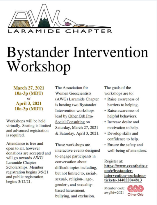
View On WordPress
0 notes
Photo


Luciana had a fabulous time visiting Dinosaur National Monument in northeastern Utah. She got to see the enormous two-story exhibit hall that’s based around an ancient mud flow in the Late Jurassic (150 million years ago) that carried and deposited hundreds of dinosaur corpses all in the same place. Millions of years later during the Laramide orogeny, the layers of hardened mud were uplifted and tilted, giving us a face-on view of the scene another few million years beyond that. Excavation of the site has revealed these long-buried and well-preserved bones, including some nearly-complete skeletons!
If you look behind Luciana in the second, third, and fourth pictures, you can see exactly how densely packed these dinosaurs are into this wall of rock. In the last picture, Luciana is in front of a cast of Allosaurus jimmadseni. That species was found in the mud flow, but the most common dinosaur species represented at the monument is Camarasaurus lentus, a four-legged long-necked dinosaur.
The monument spans across the Utah-Colorado border and encompasses some beautiful rugged deserts and scenic canyons, but we only had time to visit the museum.
49 notes
·
View notes
Note
☕️ The Rocky Mountains?
Greatest mountain range ever uplifted! It’s got something for everyone. Painted Desert? CHECK! Weird sharp foreboding spires? CHECK! Hot Springs, Geysers, Fumaroles, and Mudpots? OF COURSE! Sand Dunes? YOU BETTER BELIEVE IT’S GOT DUNES!
It’s an amazing open air museum of the natural sciences. There is nothing not to love.
Well, there’s mosquitoes and habitat loss, but there’s very little not to love!
Also The Grand Canyon is absolutely part of the Rockies because the Rockies is comprised of multiple ranges already, and the Grand Canyon was made by the Laramide Orogeny. I won’t die on that plateau, but I’ll argue it ambiguously because the naming of groups of things is subjective!
Here are some pictures of places in the Rockies I like:


send me a ☕️ and a topic and i’ll talk about how i feel about it
115 notes
·
View notes
Text
A hipster geologist walks into a bar in Oregon. He shakes his head at the seismologists also in the bar. "I liked mountains before the Laramide made them cool."
9 notes
·
View notes