
Don't wanna be here? Send us removal request.
Statistics
We looked inside some of the posts by blueskymostar-blog and here's what we found interesting.
Average Info
Notes Per Post
4
Likes Per Post
4
Reblog Per Post
0
Reply Per Post
0
Time Between Posts
6 days
Number of Posts By Type
Link
1
Text
14
Video
2
Last Seen Tumblr Blogs


Fun Fact
The Tumblr office adopted Tommy, an 11-year-old Pomeranian.
Link
2 notes
·
View notes
Text
Bosnia & Herzeg. club's in European Cup's EP1 (1/3) (English subtitles)
youtube
0 notes
Text
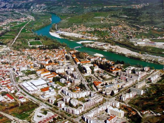
Mostar Eternal City
youtube
0 notes
Text
BH cities: S T O L A C
youtube
0 notes
Text
Capljina
Wider space of today’s Čapljina, which was called Luka in the middle age, is situated on three rivers – Trebižat, Bregava, Krupa and Neretva. It was named Čapljina after mash bird “čaplja” (heron). From new part of the town to Mogorjelo was mash, which was inhabited with different birds, included herons. Under this name Čapljina was first mentioned in one Turkish document from 1475-1477.
Also, it is mentioned in 1632 as a village of Mostar′ s district under cadi′ s authority. The most important settlements with traces of Hellenistic culture in the area of Čapljina were Mala and Velika gradina (acropolis) above Čapljina, where traces of fine Greek pots and number of fragments of amphora have been found.
Awaking of Čapljina′ s area from medieval dream begins in 1885 when the village belonged to district of Ljubuški. Ten years later, in 1895 there were 1007 inhabitants here. In that time railway is finished and Čapljina is settled with nearby settlers as with workers from nearby towns.
In 1904 when the railway station was built, the heart of the town is formed, what brings village Ćapljina from brows under Gradina. After the Second World War the town becomes urban. In 1962 Čaplina got its first urban plan. The parts of Čapljina are: Gradina, Vrgorac, Muša, Čapljina city and new part of the town. Nearby settlements are Dretelj, Tasovčići, Grabovine and Struge.
0 notes
Video
youtube
OLD TOWN BLAGAJ Medieval and Ottoman castle
0 notes
Text
Bosnian Olympic mountain: Jahorina
Jahorina is a mountain in Bosnia and Herzegovina, located near Pale in the Dinaric Alps. It borders Mount Trebević, another Olympic mountain. Jahorina's highest peak, Ogorjelica, has a summit elevation of 1,916 metres (6,286 ft), making it the second-highest of Sarajevo's mountains, after Bjelašnica at 2,067 m (6,781 ft).

Mount Jahorina hosted the women's alpine skiing events of the 1984 Winter Olympics.[1]
Jahorina is located 15 km (9.3 mi) from Pale and 30 km (19 mi) from Sarajevo. The international airport in Sarajevo is located 33 km (21 mi) from Jahorina, connected with the ski resort by a new motorway.
Ski-resort
Jahorina Olympic Ski Resort is the biggest and most popular ski resort in Bosnia and Herzegovina and offers a variety of outdoor sports and activities. It is primarily a destination for alpine skiing, snowboarding, hiking, and sledding, with over 40 km (25 mi) of ski slopes and modern facilities. The average snow depth on ski runs during February is 106 cm (42 in) (ten-year average).
The Jahorina ski lift system was upgraded in 2012 and 2013 with new Leitner chairlifts. Together with a gondola lift (under construction), Jahorina has one of the most modern lift systems in the region. An 8-passenger gondola will connect the town of Pale and the ski resort, and open up 15 km (9 mi) of new ski runs.
Winter Olympics
Jahorina is well-connected with the main transport routes in Bosnia and the region. Ski resort is 15 km (9 mi) away from the town of Pale and 30 km (19 mi) away from the capital Sarajevo an International airport Sarajevo.
Jahorina is reached by a 4 to 6 hour drive from all major cities in the region: Belgrade, Zagreb, Split, Podgorica, and Ljubljana.
0 notes
Text
Archaeological field of Badanj
Archaeological field of Badanj is situated in Borojevići, near Stolac. Archeologically this finding is placed in the late period of early Palaeolithic, i.e. 13 000 – 12 000 B.C. It was found in 1976. The engraving was found there, which was the first finding of that kind on the east coast of Adriatic. Badanj is very rich Palaeolithic ′ s and multi-level cave′ s finding. Badanj is a sot of a cave beside shallow recess in a rock, which is sheer descending on the right bank of Bregava, and archaeologically it is very important area, placed under rock,where Palaeolithic Homo Sapiens periodically lived.

By the amount and nature of found materials we can only talk about accidental and short period of human living from Palaeolithic until Middle Age. Two fazes of Palaeolithic on the area of Badanj can be defined by the presence of many changes:
The faze of glacial period
The faze of early postglacial period
Fauna shows important changes, i.e. different climate in the first and second faze, but in both fazes deer is dominant (e.g. harpoon made of deer′ s horn). Small groups or communities of hunters lived on Badanj in short time periods.
According to big numbers of founded deer′ s bone and objects made of deer′ s horn, it is assumed that people lived here mostly in periods from March till May. At the bottom of the cave there was a fire-place, as a centre of life. According to the fauna′ s analyses the number of people who could satisfied their needs there was 10-15 persons. Close to the Badanj there are two not enough researched findings: Crvena pećina and Drenovačka pećina (caves). Finding of engraved drawing in Badanj′ s rock is extremely important. It is carved into oblique surface of ironed rock which is broken from cave′ s massif.
The drawing probably represents the figure of a horse watched from the right side and attacked with arrows. The cut is 5 mm deep. Hunting is usual theme, and basic of this art was visual mastering of animals and nature.
0 notes
Text
Herzegovina garden story
youtube
0 notes
Text
The lake Ramsko jezero
This artificial lake has been created in 1968. The bed of the river Rama has been baffled.in its upper stream near the village Mluša by a dam made of stone fill up with an upstream concrete screen. The dam is about a 100 meters high. Its width in the foundational joint is about 305 meters.
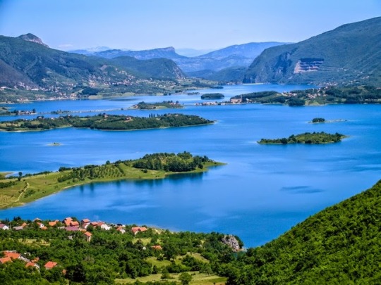
The lake is a real beauty. It is about 70 to 100 meters deep by the dam. The distance between the dam and Varvara is about 7.5 kilometers. The length of the shore is about 29 kilometers. The island Šćit is made even more beautiful by a dike. Other two little islands, Umac and Škarine, brake the monotony of the surrounding. The lake has a semicircle shape, with many bays. The mild dropping of the bays makes the lake accessible from all sides. The deepest point of the lake is at 95 meters under the water. It is located on the land that was fertile and had a lot of agricultural potential.
There is a lot of loam on the bottom of the water. That is why the shores of the lake are very muddy. This happens because of the constant oscillation of the water. The water is often blurred, especially in the afternoons when the wind inhibits the waves that hit the shores. The lake is normally clear and green colored. The lake fills up after the enormous amount of the snow melt, but the constant emptying of the accumulation in order to produce electricity waste the water.
That is why the lake is almost always half empty in the summer. The regular flow in of the water comes in from Rama, Buka and Krupić, and from other small brooks and springs. The spring of Rama is located underneath the surface of the lake. This river is very cold at its spring (7.5 degrees), but the surface of the lake warms up quickly for the swimmers. There are a lot of them when the lake is full. Sometimes the parts of the lake freeze during the winter. There are many kinds of fish in the lake, like trout carp, pikeperch...there are not many vessels to be seen on this lake, because of the constant oscillation of the water.
The traffic until the lake is available by a road from Prozorand by a newly opened road that leads from Tomislavgrad, Livno and Split. It is possible to come to the Ramsko jezero even from Prozor over Blidinje, Kedžare and Orašac.
0 notes
Text
Dear friends
You can subscribe to our youtube channel and follow our video production. At this time, you have 15 video material available. All our documentaries have English subtitles.
Please subscribe to our channel and follow our documentary films. Explore with us Bosnia and Herzegovina and culture, history, sport and society of the Balkan and South-Eastern Europe.
https://www.youtube.com/channel/UC0ZCv4L_ceQNAccefzGODbQ/videos
0 notes
Text
Osman Djikic (poet)
Osman Đikić was a poet, publisher, member of the workers` movement and a national revolutionary during the Austro-Hungarian occupation. Đikic was a passionate activist in the struggle for religious autonomy of the Muslims in Bosnia and Herzegovina on the beginning of 20th century.

He was a constructive member of the Serbian and Yugoslavian ideas, and sought after cooperation between the Muslims and the Orthodox.
He published his works in magazines like “Bosanska vila”, “Zora” and “Behar”, and had two collections on his own: “Muslimanskoj mladeži” and “Ašiklije”.
Osman Đikić died in 1912, and was buried next to the entrance of the Karađozbeg`s Mosque. In his honour, a monument was built over his tomb in 1936. During the Second World War it was destroyed, but rebuilt right after.
1 note
·
View note
Text
Tešanj Castle: One of Oldest and Biggest in Bosnia
The old city of Tešanj, where the castle is located, was built on a hill in the valley, along the river Tešanj, on a steep and partly isolated cliff of a hill, hardly accessible from the three sides of the town of Tešanj in the north of B&H. This beauty on the hill of Tešanj has existed for already three thousand years.

This fortified settlement from the Medieval period belongs to a group of larger, fortified towns on the plateau, specifically built on the top of a rocky hill from which you can see the whole city of Tešanj in a valley.
The castle is considered to have been built during the Bronze Age, and until today, has fallen into a kind of oblivion and there was no special interest in one of the oldest fortresses in B&H today.
The Tešanj castle, after the one in Jajce, is considered to be one of the biggest fortresses in B&H.
However, it is important to note that in the 1970’s its multiple protection that lasts until today began.
The fortress certainly provokes the interest of passers by, tourists, and a team from Anadolija decided to visit this somehow forgotten fortress, which is considered to be one of the oldest buildings in B&H.
”Tešanj, with its fortress, developed into a ravine on the slopes of the hills, and in the middle a very interesting defensive point has been raised, a hill, from which it is obvious that it is from the Bronze Age and to the present day developed into a fortified object or fortress”, said professor Mirza Hasan Ćeman.
He said that evidence from the period of the Bronze Age shows that there were settlements of this narrow territory from the second millennium BC until today.
Speaking about the history of Tešanj and its fortress, Ćeman explains that the castle developed into a feudal fortified building during the Middle Ages that later grew into a residential building of the feudal nobility.
”It never developed into a significant administrative center. However, in the 15th century it came under the role of the brother of the Bosnian King Stjepan Tomaš Radivoje Krstić”, he explained.
The castle was under Ottoman rule since 1463, but it is not known whether it was under an Ottoman military garrison.
”It is not clear whether in the 15th century there was a settlement at the foot of the fortress, but it can be assumed, because the Franciscans were obviously there for a population”, said Ćeman.
He thinks that the castle came under permanent Ottoman rule in 1520 and a permanent military garrison was set up.
Over the next century the castle was repaired, restored and enlarged in accordance with the political and military developments and economic opportunities of the Bosnian Pashaluk.
”The Tešanj castle existed in the Middle Ages as well, and it was taken over by the Turks. I think, based on personal research from the field, that during the time of Sultan Sulejman the Magnificent an entrance was erected, which ensured entrance into the castle”, explained Ćeman.
The Professor explained that the Austrian Army led by Prince Eugene of Savoy attacked and took the castle in 1697.
”This heavy siege of the Tešanj castle and the city ended after three days of unsuccessful attacks. The Autrian Army retreated in the direction of Slavonia”, said Ćeman.
Speaking about its importance today, the Professor explained that at the end of the 18th and beginning of 19th century, its significance weakened.
”With the arrival of Austria it has been sinking into oblivion. New techniques of warfare and new funds minimized the importance of the castle, although during WWII, the same object was taken by the Independent Croatian State and on 9 September, in a very specific way, it was taken over by the unit of the People’s Liberation Army”, explained Ćeman.
Since then the castle has again fell into oblivion, and only in the 1970’s did its multiple protection begin and lasts until today.
The castle has been preserved to this day thanks to the interventions during the 1960’s, when one tower was protected from decomposition as a result of lightning.
It has survived many wars, conquerors, and is still standing proud on a hill in Tešanj and defies time and its enemies.
0 notes
Video
youtube
0 notes
Text
BH cities: TOMISLAVGRAD
Tomislavgrad (former name Duvno) – the city and the centre of municipality in south-west part of Bosnia and Herzegovina, one of the municipality which belongs to Livno district. It is a part of Herceg-Bosna county.

In 1925.king Aleksandar Karađorđević marked 1000 year anniversary of Croatian kingdom by naming this city after Croatian king Tomislav. It is assumed that he was crowned at Duvanjsko polje (Duvno field) in 925. The city kept this name until 1945. Since that year until twenties of the 20th century the city is called Duvno again. However the city regained its name Tomislavgrad in the end. In the honour of the first Croatian king Tomislav there is a bronze statue of him in the city. Beside monuments the city has beautiful basilica dedicated to St. Nikola Tavelić, the first Croatian saint. There are a few statues of other saints near basilica.
In Duvno area, high mountain area of south-west Herzegovina is subsiding towards Adriatic Sea. Duvanjsko polje is typical table – land aroused in ancient geologic time by tectonic subsiding of the ground and lake sedimentation and detritus of constant and occasional water-flows. Big sedimentation of coal originated there. It is situated on 860-900 m height above sea level. It is lower than Kupreško polje (1100-1200 m), and higher than Livanjsko polje (709-808 m). The field is 20 kilometres long and 12 kilometres wide. It has surface of 125 square kilometres.
Geologically, by composition of its ground, this is the area of extremely big Dinaric rocky area. By its location, composition of the ground as well as by physical and mental features of its inhabitants, it is more a part of Dalmatia and Herzegovina than of Bosnia. And it is also possible to say that it is a three border point which divides and connects. So the fact that its inhabitants come from all three areas is not surprisingly.
Duvanjsko polje is suroundined with mountains on every side. On north-east and east it is bordered with Ljubuša, Vran and Smiljevača, Gvozd on the south; on the south-west and west lies Midena and lower Grabovica, on the north and north-west Tušnica and Jelovača arises. Most of these mountains are bared.
Although it rains a lot here, there is still a lack of water, because enormous amount of water loses underground. The only river Šujica is underground stream which has spring in Šujica and sinking in Ponor, and rises again in Prisoje as Ričina. Today it fills Buško Lake. Its affluent Drina flows only during little part of the year. The main source for the city and nearby villages is stream Ostrožac which never runs dry. Two thirds of Buško Lake are in Tomislavgrad′ s municipality.
0 notes
Text
Mirza Delibasic
Mirza Delibašić (January 9, 1954 – December 8, 2001) was a Yugoslav and Bosnian professional basketball player. He was born in Tuzla, located in northeastern Bosnia and Herzegovina, in the former Yugoslavia. Delibašić is widely considered as one of the best shooters in the history of European basketball.

Delibašić was named one of FIBA's 50 Greatest Players in 1991. He was enshrined into the FIBA Hall of Fame in 2007. In 2008, he was named one of the 50 Greatest EuroLeague Contributors.
Mirza Delibašić, nicknamed Kinđe, led his club Bosna to the EuroLeague Championship in 1979. He played his first games at age of 15 for KK Sloboda Dita, Tuzla's basketball club. Three years later, 1971, he signed a contract with KK Bosna. After leaving Bosna, Delibašić went to the Spanish League, where he ended up being considered one of the best players ever to play for Real Madrid, along with the likes of Juan Corbalán, Wayne Brabender, Fernando Martín Espina, Fernando Romay, Dražen Petrović, and Arvydas Sabonis.
In his club career, he won numerous titles in European club competitions. In addition to having played together for their Yugoslav national team, Mirza Delibašić and Dražen Dalipagić, also played together with Real Madrid. Their performance in a 1983 EuroLeague game versus Cibona, in Zagreb, is only one of the many highlights of their careers.
In that game, Delibašić scored 26 points and Dalipagić 33. The game appropriately finished with a two-on-one fast-break, with Delibašić making a behind-the-back fake pass to Dalipagić, and passing by a defender for a two-handed dunk at the buzzer. Cibona's fans put aside their team's loss in the game, and showed their appreciation for the Bosnian stars performances, with a standing ovation at the end of the game.
En route to a place among the greatest European players, Mirza Delibašić won everything there was to win with the Yugoslavia national basketball team, including: the Summer Olympic Games gold medal at the 1980 Summer Olympics, EuroBasket gold two times (1975 EuroBasket and 1977 EuroBasket), and the FIBA World Cup gold at the 1978 FIBA World Championship.
In August 1983, 29-year-old Delibašić suffered a near-fatal brain hemorrhage, forcing him to permanently retire from basketball.
He lived in Sarajevo throughout the 1992-1996 siege of the city. Simultaneously, Delibašić coached the newly-established Bosnian national basketball team at EuroBasket 1993 in Germany, finishing in 8th place.
His final years were marked by persistent health problems, due to his heavy drinking, which led to his death in 2001, at the age of 47, in Sarajevo. Thousands attended his funeral in Sarajevo, and KK Bosna renamed its arena in his honor.
Awards and accomplishments
2x Yugoslav League Champion: (1978, 1980)
Yugoslav Cup Champion: (1978)
EuroLeague Champion: (1979)
Club World Cup Champion: (1981)
Spanish League Champion: (1982)
FIBA's 50 Greatest Players: (1991)
Bosnia and Herzegovina Sportsman of the 20th century: (2000)
FIBA Hall of Fame: (2007)
youtube
0 notes
Text
Jajce - Bosnia and Herzegovina
youtube
1 note
·
View note