
Welcome to my blog! I am Ece Gani and I am 20 years old. I am a first year student at METU City and Regional Planning department. This is my blog that I use as a sketchbook for the CRP 101-102 lecture.
Don't wanna be here? Send us removal request.
Statistics
We looked inside some of the posts by ecegani and here's what we found interesting.
Average Info
Notes Per Post
0
Likes Per Post
0
Reblog Per Post
0
Reply Per Post
0
Time Between Posts
8 days
Number of Posts By Type
Text
17
Last Seen Tumblr Blogs


Fun Fact
Tumblr was acquired by Yahoo for $1.1B in 2013.
Text
City Series #7 “Water Management and Design in the Netherland”
Guest Speaker: Roberto Rocco, Associate Professor of Spatial Planning
In the fourth episode of City Series, our guest speaker was Associate Professor Roberto Rocco from Delft University. Rocco started his presentation by introducing Randstad and presented information about this city district in the Netherlands. He described TuDelft and talked about the Netherlands’ relationship with water. He said much of the Netherlands is below sea level and water is a very important factor in the planning of the city.

The blue areas appearing on this map indicate areas below sea level.
Rocco talked about deltas in the rest of the presentation. He presented the extremely complex and fragile river deltas and their features. Deltas have great potential and have excellent soils for agriculture. In addition, river deltas are interrelated areas. We can obtain many natural resources, especially fish, from deltas. However, since these are fragile areas, care should be taken very carefully.
Later in the presentation, he explained what Randstad is. In the west of the Netherlands, the area circled in red on the map below is the Randstad area. This area is a purely urban agglomeration. Rocco highlights the contrast of this area, which is full of deltas, despite the very fragile environment that there is so much urbanization in this area. Located in the Randstad area, there is a green area surrounded by Amsterdam, Rotterdam, Utrecht, and Lahey. This area is more empty and is called the green heart by the locals.

Picture 1.2 from Roberto Rocco’s Presentation
He then explained how societal models relate to water management. He talked about the Polder model in this regard. He explained the Polder model with three features of the model. These features are; collective action, trust in institutions, and consensus-seeking. This model explains to us the idea of top-down planning and bottom-up planning.

Picture 1.3 from Roberto Rocco’s Presentation
Regional planning is very important in terms of understanding and sustainability of regional activities. Rocco first talked about the importance of cross-industry operations. Regional plans must work with all elements in the region. The region should be considered as a whole and plans should be long-term. It will be much safer to work on small projects that will last a long time but will be long-lasting, adapt to change, and ensure sustainability, instead of completing very large projects in a short time. The regional planning process also brings together the public and private sectors and strengthens their links with the community.

Picture 1.4 from Roberto Rocco’s Presentation
In the Netherlands Delta Program, security, climate-resistant environment, and drought problems can be overcome with regional planning for now and for the future. For example, freshwater can be supplied even in dry seasons. The purpose of the program is to solve all these problems and continue in the same way. Delta program offers permanent solutions and works with nature.

Picture 1.5 from Roberto Rocco’s Presentation
In his presentation, Rocco describes the Delta Program as not reactive but preventive. He mentions that the focus of the program is not to fight disasters, but to plan to prevent disasters before they happen. Regional planning requires taking precautionary measures by considering all the disasters that may occur or the risks that may cause these disasters.
I think it is important to have a regional planning approach. This is because it is impossible to intervene and restore everything to the way it was after some big problems have arisen. Instead of intervening after disasters occur, the occurrence of these disasters will become almost impossible in a long but effective process with regional planning. Thanks to regional planning, such insurmountable problems can be eliminated from the very beginning, as in the examples of drought and climatic changes that Rocco gave in his informative presentation. With regional planning, even if there is a drought, access to freshwater resources can always be possible. It can be costly and tiring because it requires a long process, but it provides a long-term guarantee as a result. Instead of producing temporary solutions to the disasters that are currently occurring, permanent salvation can be achieved with regional planning. Because temporary solutions are not tied to a result and repeat themselves constantly. This causes us to be unable to make any progress in solving the problem.
.......
02.06.2021
0 notes
Text
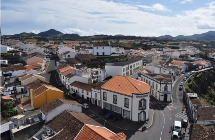
City Series #6 “An Island Within An Island: The Case of Rabo De Peixe”
Guest Speaker: Ines Vieira Rodrigues, PhD Candidate
Ines Vieira Rodrigues was our guest speaker in the fourth episode of the City Series. She started her presentation by talking about the location of Rabo De Piexe. Rabo De Piexe is located on Sao Miguel Island in the Azores. It is located in a region that occupies three percent of Portugal's territory. In terms of its location, it serves as a shelter to the harbor and is a place that receives intense sun. Its slopes are not too steep.

Picture 1.1 from Ines Vieira Rodrigues’s Presentation
Rodrigues first introduced the place and meaning of names. She talked about the people living in the area and offered some statistics. 70% of the people living here are illiterate and the general population is between the ages of 15-65. The economy is based on fishing and agriculture as they are illiterate. However, due to the fact that the areas close to the sea are associated with the lower layer, the fishing profession is not given sufficient importance. Agriculture, on the other hand, is carried out only for the production of products consumed by its own people. There is no foreign trade. Rodrigues also mentioned that families consist of at least 4 people. The people lead a traditional lifestyle and consist of people who are very loyal to their traditions.

Picture 1.2 from Ines Vieira Rodrigues’s Presentation

Picture 1.3 from Ines Vieira Rodrigues’s Presentation
In the presentation, local problems of the region were also mentioned. Rodrigues mentioned that the social segregation is too much, even that the region is divided into High Zone and Low Zone. While poorer people live near the sea, there are people who are considered rich in the interior.
There is a hierarchical order in the region due to social and economic inequality. The solutions proposed to eliminate this socio-economic inequality are insufficient and as a result, the needs of the people cannot be met. Poverty has become the most important problem in this region, suggesting that the region is ‘marginal’. Locals have been labeled with this term, as the media also supports this view.
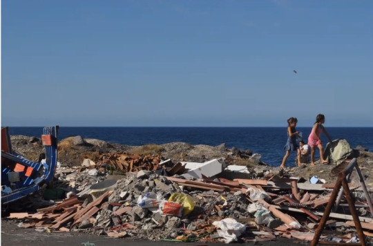
Picture 1.4 from Ines Vieira Rodrigues’s Presentation

Picture 1.5 from Ines Vieira Rodrigues’s Presentation
In order to eliminate this problem, in my opinion, the priority rights of people should be ensured. For example, the literacy rate should be increased so that the people of the region should not have to make a living from fishing and agriculture alone. In addition to these, they should enter the field of trade and tourism, have a job in these fields and direct their economy.
The regional government has provided people with some housing in the name of providing more living space. But this step was not enough to solve the problem. The reason for this was that the houses were built by ignoring the lifestyle of the people of the region and the crowded family structure.
Picture 1.6 from Ines Vieira Rodrigues’s Presentation
Similar Examples of Rabo de Peixe Urbanization from Turkey
We see similar situations in Turkey. Likewise, in Turkey, socio-economic differences can be seen very clearly in some regions. Even among the districts of a city, class differences occur. An example of this is that there are great differences in the way of life of the people in Çankaya and Altındağ districts in Ankara, their literacy rates, the opportunities they can access, and their economic status. In addition, there are great inequalities in our country, even between the east and the west, in terms of lifestyles and opportunities available to people. Although the west of Turkey is developed in many areas such as education, transportation, and health, the same is not the case for the east. The reason for this is that the government does not provide equal opportunities and socio-economic separation between rich and poor.

This is the picture of Çankaya, Ankara

This is the picture of Altındağ, Ankara
......
02.06.2021
0 notes
Text
City Series #5 “City Planning and The Eveyday: A Closer Look At Campo De’Fiori in Rome
Guest Speaker: Asst. Prof. Nele De Raedt
In the fifth episode of City Series, our guest speaker was Nele De Raedt, an assistant professor of architectural theory, history, and criticism at UCLouvain in Belgium. She started her presentation with the city of Rome, which has spaces and streets that people think are well designed. First, she presented Piazza Farnese, an important square with its city-scale architecture, with visuals. Afterwards, we saw Piazza Navona, Piazza del Popolo, Piazza di Spagna and Piazza San Pietro.
(These pictures are taken from Nele De Raedt’s Presentation)

Piazza Farnese
This is one of the most important squares. The Palazzo Farnese Roman Palace, which has an important historical value, is located in this square. In addition, the square has two fountains.

Piazza Navona
This square with many statues served as a city market in ancient times. Many events have been held in this square over the years.

Piazza del Popolo
Various public events are held in this square, where the Leonardo da Vinci Museum is also located. It means People's Square and there are 3 churches around it.

Piazza di Spagna
This square, which is a commercial center, is connected to an important church by the Spanish steps. In addition, it is in a good location for scenery.

The main subject of the presentation, Campo de'Fiori Square, is a place where people continue their daily activities. That square runs along a street and lacks monumental features like the others. Raedt briefly mentioned Campo de'Fiori Square at the beginning of the presentation and continued the presentation with the theories of two French intellectuals.


Campo De'Fiori
The plan of this square has been changed many times. The reason for the changes was to make the city of Rome the capital of Christianity. A fountain was placed in the center of Campo de'Fiori Square, which later became an important feature of the municipality. Street and port connections in the square have been successfully planned. Too much accumulation of water was a problem as it harmed the market. As a solution to this, the port was converted into workplaces and the palace was demolished and a marketplace was built instead. In this way, today this square has become a more useful and commercial area where daily activities take place.

The Case of Turkish Cities
An example of the Campo de Fiori square in Turkey is Kızılay Square in Ankara or Taksim Square in Istanbul. These squares are the squares where business places and commercial areas are gathered together. The fact that they are easily accessible and most roads are connected to these squares makes these squares central places for people. Apart from these squares, Gezi Park, which is known for the events and protests that took place in 2013, is another square that has become a symbol both in terms of green space and is remembered thanks to the unforgettable events.

This is the picture of Kızılay Square

This is the picture of Taksim Square
.....
02.06.2021
0 notes
Text
City Series #4 “City and Nature Complexities: The Case of Brisbane”
Guest Speaker: Ali Rad Yousefnia, PhD Candidate
In the fourth episode of City Series, our guest speaker was Ali Rad Yousefnia from the University of Queensland. He started his presentation by talking about the relationship between the city and nature. He described the relationship between the city and nature as complex. Should we separate nature and city, or should we consider both together?

This picture was taken from: https://mocah.org/321078-city-nature-landscape-forest-trees-autumn-sky-scenery-4k.html
Yousefnia talked about natural elements in his presentation. In this regard, he especially emphasized water, which is the common element that feeds gardens and agriculture. He explained some of the methods used to control water, which can be considered as the main resource for cities, within the city. He cited aqueducts, qanat, and ab anbars as examples of methods used to control water.

Pictures from Ali Rad Yousefnia Presentation


Picture 3.1 from Ali Rad Yousefnia Presentation
Ali Rad Yousefnia continued his presentation by talking about Brisbane, the capital of Queensland, one of the states of Australia. Yousefnia referred to Brisbane's topographic structure. He said the city has rough terrain and a warm climate. Afterward, he started to give numerical values about green areas in the city. In order to better understand these values, he compared the green space rates per capita in the cities of Ankara and Brisbane. The city of Brisbane covers an area of 15,842 square kilometers and has 155 inhabitants per square kilometer. In Çankaya, the center of Ankara, there are 3400 people per km2 in an area of 268 km2. As a result of these statistics, while the rate of green space per capita is 112m2 in Brisbane, this rate is 2m2 in Ankara. This incredible difference made me think that in many cities of our country, especially in Ankara, there is no planning for green areas, green areas are ignored, and it created many questions in my mind. While planning the cities, why are the historical values or nature in that area ignored? After the city is designed, are these values tried to be brought to the city? If we are going to try to regain these values, why don't we plan by integrating them into the city from the very beginning?
After these statistics, Yousefnia gave examples of designs suitable for land structures. He mentioned that while designing on flat land, more regular designs will occur. But these regular designs create a monotonous image for us. On the other hand, more diverse designs can be created on sloping terrain.

Picture 4.1 from Ali Rad Yousefnia Presentation
In the continuation of the presentation, he talked about the river in the city of Brisbane. This river is also used for transportation purposes. He said the river is one of the longest in Queensland and shared a video explaining why a river's flow path is curved.
youtube
He said that after heavy rains in the city, the river flooded the city. He mentioned some numerical data about these floods. For example, he mentioned that 35 people died as a result of the first flood in 1893 and that 16 people lost their lives as a result of the flood in 1974. These events showed us that when designing a city, we need to design a whole with nature by considering the risks that nature may pose.

Pictures from Ali Rad Yousefnia Presentation
Finally, Yousefnia mentioned that the settlements around the Norman Creek are at risk of flooding due to precipitation. As a solution to this, he suggested that the region should be settled in a different place or that the current region should be transformed into an area compatible with nature.
Conclusion
As a result of this valuable presentation, I realized how important the relationship between design and nature really is. While designing, we should not focus only on the purpose of the design, we should design by considering the relationship of this design with nature and all the risks that may occur afterward. In designs where nature and the city are not considered together, natural disasters are inevitable. An example of this can be seen in the recent Izmir earthquake. As planners, we have to consider the advantages and disadvantages of the nature we live in together. We have to create settlements in a way that minimizes the risks that nature may pose. We should consider water, soil, historical values, and many other elements as the basic elements that make up the city and make our designs in line with this framework.
In addition, the most important part of the presentation for me was the comparison of Ankara and Brisbane city in terms of green space. As a result of this comparison, I realized that green areas are gradually decreasing and that they are generally put into the background in designs. This made me worry about the build stack that might occur in the future. For this reason, I have understood more clearly that we have to add the nature we are in at the very beginning of the design to the designs and work with nature.
.......
02.06.2021
0 notes
Text
City Series #3 “Ephesus”
Guest Speaker: Dr. Martin Steskal
In the third episode of City Series, our guest speaker Dr. Martin Steskal. In his presentation, he talked about the history of Ephesus Ancient City and the location of the city. Steskal started his presentation by explaining how Bülbül Dağ and Panayır Mountain surrounding the ancient city of Ephesus are located and shaped around the city.

Picture 1.1 from Dr. Martin Steskal’s Presentation
Afterward, he talked about the most important element that the city of Ephesus has. The city having a harbor was the most important feature of the city. The reason for this was that the people living in the city were able to trade and make a living thanks to the port. The most important factor determining the economy of the city was the port located here. However, as the years passed, the water began to recede more and more. A water withdrawal of 18 km has occurred. Consequently, small settlements have shifted to the west in time to minimize the withdrawal of water. When this was not enough and the water was closed due to both natural conditions and people cutting down the trees, people made an artificial canal from the sea to the city as a solution.
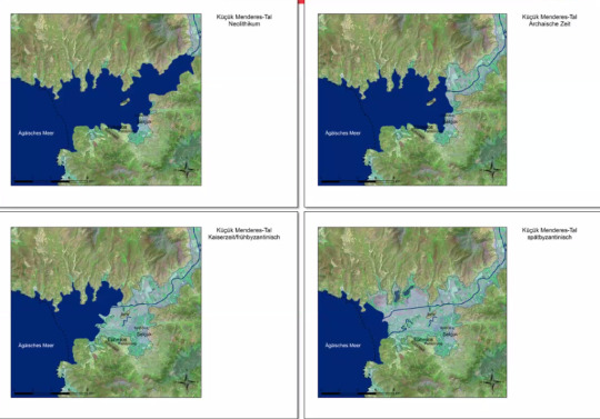
Picture 1.2 from Dr. Martin Steskal’s Presentation
After this presentation, I exactly understood that while designing a city, the relation of the area with its environment, the existing values found there, the dynamics of the area itself, and the tendencies and movements of the people living there are really important. The people in the city of Ephesus first cut down the trees to shelter, then the withdrawal of the port, which is very important for the people due to the cutting of trees and natural conditions, and the worsening of the economies of the people who make trade thanks to this port, and the efforts to build an artificial port. I think all this is actually the result of playing with the city's dynamics and current values. For this reason, while continuing my own midterm project, I tried to analyze what I did wrong after this presentation and whether the area I designed spoke to its environment.

This is my first conceptual design of Ephesus
After the valuable information I learned from Martin Steskal's presentation, I worked mostly on the topography of Bülbül Mountain and Panayır Mountain in my mid-term project. How can I use this space as a whole with its surroundings? How can I blend my clusters with topography? How can I show people's orientation? How can I relate to the current values of the Celsus Library, Theater, Agora and Harbor? I made progress in my project by searching for answers to all these questions.
Finally, I have identified the harbor and theater as reference points for the topography area that I will design. I created an entrance and exit to the topography area from these reference points. I reshaped the given topography area by angling it. The reason I gave the angle was to control the orientation and movement of people and direct them in this area.

This is my first topography model and reference points
I positioned my clusters in the topography area that I shaped, by blending them into an angled order. Thus, the relationship of people with the port, theater, and commercial areas between these two points was established. At the same time, Agora and Celsus Library formed a whole with the cluster area. A flow and dynamics of the cluster field have been formed within itself. The point where the transition from the port and the theater to the cluster area was the heart of the area I designed in the topography.

This is my midterm project
........
22.05.2021
0 notes
Text
In-Class Exercise: Group Work 3
We did group work on how to define a neighborhood, what we want to change in a neighborhood.

......
05.04.2021
0 notes
Text
Assignment #3 Storymap
In this week’s assignment, we were asked to create own StoryMap in https://storymaps.arcgis.com. I created my StoryMap about Ankara, the city where I live. There are some photographs of my StoryMap in below.


Also, you can access my StoryMap at the following link:
https://storymaps.arcgis.com/stories/12a62775577c4a5299dafd3a10e20a88
.....
04.04.2021
0 notes
Text
In-Class Exercise : Group Work 2
In this group work, we were asked to examine the land given to us in terms of topography. We developed a scenario on this land. By examining the area, we decided where the areas such as entrance and exit or gathering should be, by looking at which parts are high and which parts are low.

This is the base given to us.

This is our composition and scenario.
.......
30.03.2021
0 notes
Text
In-Class Exercise: Group Work
City Series #1
Guest Speaker: Niloofar Amini, PhD

......
29.03.2021
0 notes
Text
Assignment #2 Half & Half
In this week's assignment, we were asked to create a conceptual drawing, a computer drawing, and an abstract design by developing our assignment last week. We created these drawings with reference to our final project, May I Take Your Order.

Picture 1.1 My Conceptual Drawing by Freehand
In Picture 1.1, you can see my conceptual diagram. While creating my conceptual diagram, I tried to give more clear and detailed information. I showed the connections between places with the help of arrows. I also used arrows to indicate the flow within the space. I indicated the open areas with dashed lines.

Picture 1.2 My Conceptual Diagram by Computer
In Picture 1.2, I showed my conceptual diagram by computer drawing. I used one colour, green to indicate trees. I used stars to show reference points. While I created this conceptual diagram, I used PowerPoint.

Picture 1.3 My Abstract Design
In Picture 1.3, you can see my abstract composition about conceptual diagram. I put a big yellow circle to the left of the composition to show the meeting area. Also, I put two small circles to the right of the composition to indicate the reference points. I used yellow lines/ rectangles to show the main flow over the entire area.
.....
28.03.2021
0 notes
Text
In-Class Exercise: Collage as a Visual
In this in-class exercise, we manipulated the photo given to us, starting from the off-talk named Collage as a Visual, which our teachers Aybüke and Büşra made for us.

This is my composition.
........
25.03.2021
0 notes
Text
In-Class Exercise: Terrain Model
We were asked to create our own terrain in SketchUp and scale our model to 1/500. We can look at this exercise as the first work we did to put into practice the topography knowledge we learned in Timur Hodja's mapping lesson.

This is my terrain model.
.......
24.03.2021
0 notes
Text
Openning Talk “Visual Arts and Design from the Eyes of a Vision Scientist”
Guest Speaker: Asst.Prof.Dr. İnci Ayhan
Reality and Representation
The first guest speaker of our studio course this semester was Asst.Prof.Dr. İnci Ayhan. She explained to us reality and representation. Does everything we see really exist or are objects as much as we perceive?

Picture 1.1 from İnci Ayhan’s Presentation
For example, is this pipe picture really a pipe or is it just a picture representing the pipe? Even though most people say that when they look at this picture, they see a pipe, maybe it's just a representation.
She also talked about perceptual presence in her speech. She explained perceptual presence is the experience and perception of all objects that we perceive as if they actually exist. Objects actually vary according to how we see and perceive them. Sometimes when we look at objects from different angles, we can perceive them completely different than they really are. We can see examples of this situation in the images below.

Picture 1.2 from İnci Ayhan’s Presentation

Picture 1.3 from İnci Ayhan’s Presentation
What is a line?
In her presentation, she quoted the words from Visual Perception, which is the definition of line 'sudden changes in the amount of light reflected off a surface, corresponding to the boundaries of an object'.
She mentioned that in reality there is not much of a clear transition between dark and light. In fact, what we define as lines are indicators of difference. For example, the sharp transition between two textures or the distinct contrast between two colors reflects to our eyes as if there is a line between those two things. However, that point of contact is not a line. We can see an example of this situation on the horizon.

Picture 1.4 from https://www.metinaytekin.com/
Multiple Spatial Scales in the Visual Systems
Again, a situation related to perception is scale. We may perceive some pictures differently when we look at them from a distance and different as we approach them. To illustrate, in the painting created by Murat Pulat with his technique named 'diptych', it is observed that the continuity increases as the closer to the picture (Picture 1.5).

Picture 1.5 from İnci Ayhan’s Presentation
Another example can be observed in the picture below as Albert Einstein. As we move away from the picture, the person we see is not Einstein, but Marilyn Monroe.

Picture 1.6 from İnci Ayhan’s Presentation
Lines
In her presentation, she claimed that neurons in the visual system have been evolved to attain contour information (using luminance and spectral contrast). The visual system completes a picture differently with each glance. Lines are used in drawings to mark the boundaries of objects and their parts.Although there are no lines in certain areas in some images, our eyes automatically perceive as if there is a line there. The reason this happens is that the eye perceives that image as total and spontaneously completes that image as a whole.
Example 1.1 from İnci Ayhan’s Presentation
Abstraction and Gestalt Psychology
Reducing the information content of a concept is called abstraction. This reduction is mostly done in order to obtain the information required for a specific purpose more easily.
The main principle of Gestalt psychology is that the mind organizes itself to see a whole in what it perceives. The figure-ground relationship is one of the principles used by this psychology.

Example 1.2 from Baykan Günay’s Article
Consequently, when looking at an object, we tend to perceive that object as a whole, not partly. For this reason, the objects we see around us do not depend on how they actually are, but on how we perceive them.
......
03.04.2021
0 notes
Text
Assignment #1 Half & Half Project: Conceptual Drawings
We created two conceptual drawings of our final project “May I Take Your Order?”. One drawing by hand and the other in computer drawing.

This is my freehand conceptual drawing. I used little arrows to show the flow within the field. I hatched the reference points. Also, I used dashed lines to show the transition between areas.

And this is the computer drawing of my final project. I used PS when I created my drawing. I used red color to show important areas and points. The meeting area is the main area in the entire field. Therefore, I thought that the meeting area is an important area.
......
21.03.2021
0 notes
Text
In-Class Exercise: Three Conceptual Drawings
In this in-class exercise, we were asked to draw three conceptual drawings using two different styles and one freestyle.

In my first conceptual drawing, I used a bubble diagram to show the area I created in my final project. In my second drawing, I wanted to use a more abstract representation technique. And finally, my third conceptual drawing is my freestyle drawing.
.....
19.03.2021
0 notes
Text
In Class Exercise : Your Desktop Vol.2
In the first in-class exercise of the second term, we were asked to create a composition that complies with basic design principles using daily stationery objects on our desktop. We also made a composition with a computer program to measure our computer skills.
The purpose of this in-class exercise is to measure and evaluate how much we can reflect basic design principles and our computer skills.
In the photo below you can see the composition I created on my desktop.

First I created the grid for my entire composition and then continued my composition on this grid.
Secondly, in the photo below you can see the composition I created on the computer.

I used PS when creating this composition.
.....
19.03.2021
0 notes
Text
Final Assignment: “May I Take Your Order?”
A Welcome Space at METU

Picture 1.1
For the final assignment, we were asked to design the 1962 version of the METU campus. I first created my order and determined powerlines on that order and designed my project on these powerlines. I divided the flow in the campus into three main parts. The first is the part that leads to the meeting area after entering the campus. I designed this area considering the possible elements of the entrance. The second is the part at the top of the campus that goes up to the tree-dense area. The third is the part that goes up to the lower part of the campus.
After entering the campus, I have placed the meeting area in the center to allow people to meet at a central place and distribute them according to the activities they will do from there (shown in the conceptual diagram on the right in picture 1.1). This is the reason why I divide the flow within the campus from the center into three main branches.
I customized the reference points given to us in my project using the Bilim Ağacı and Çinici Gate, circular shapes, and circular acetate papers. I also used acetate paper to cover the areas I wanted semi-open. In my project, I created spatial hierarchies and volumetric relationships by paying attention to the open-closed relationship, heights, and thicknesses. This is my final assignment.

Picture 1.2
The presentation in Picture 1.2 is the presentation of my final paper. In my presentation, you can see the top view, side view, sections of my final project, and photos of my project taken from different angles. You can also see the products of the group work we made for our final project.
In our group work, we created a new order by bringing together the orders of each person's own projects in the group. Later, we searched for different powerlines on this order and created space areas on these powerlines. The areas that appear dark indicate the orientation and flow to the center in the space.
.....
15.01.2021
0 notes