
emmanuelbagac
Mountaineer's TourGuide
keep going?
8 posts
Don't wanna be here? Send us removal request.
Last Seen Blogs

kaos-al-escribir
✨ kaos writer ✨

icansayraxacoricofallapatorius
I Show Not Your Face But Your Heart's Desire

bluekyun
i’m a disaster

top-hatman
Tophatman

world-of-night-lovers
Gece Severlerin Dünyası
Text
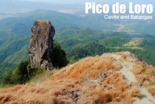
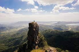
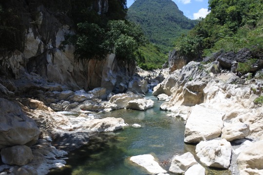
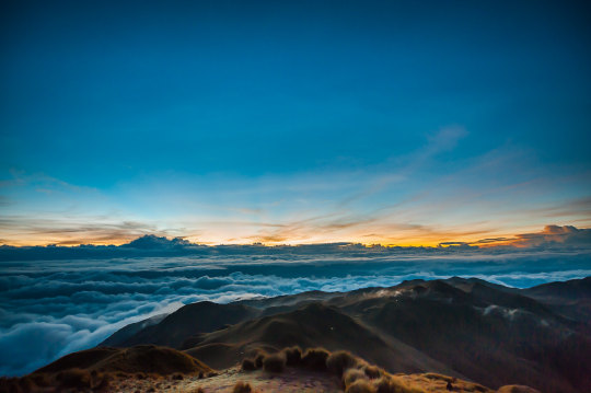
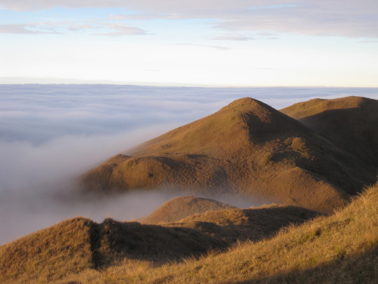
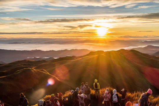
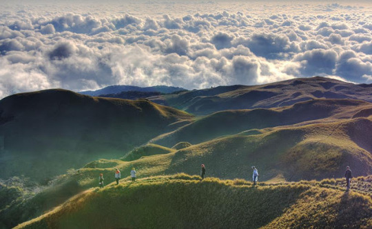
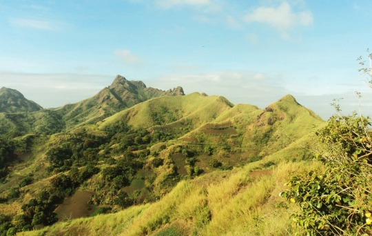
Maragondon, Cavite and Nasugbu, Batangas
Major jump-off: DENR Station, Magnetic Hill, Ternate, Cavite
Minor jump-off: Sitio Fronda, Brgy. Papaya, Ternate-Nasugbu Highway, Nasugbu, Batangas
LLA: 14° 12.855 N; 120° 38.785 E; 664 MASL
Days required / Hours to summit: 1-2 days / 2-5 hours
Specs: Minor climb, Difficulty 3/9, Trail class 1-3
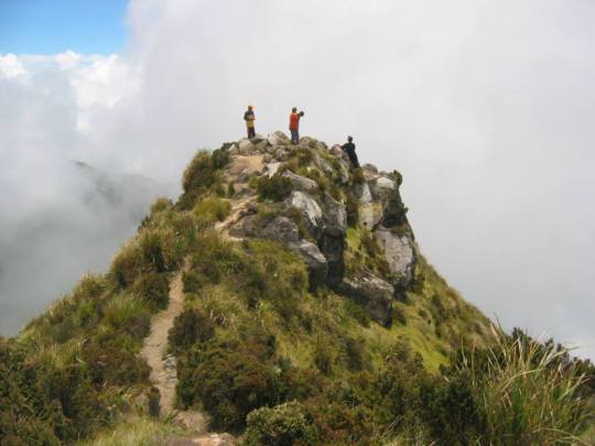
Features: Distinctive spire at the summit, forests, scenic views of Cavite
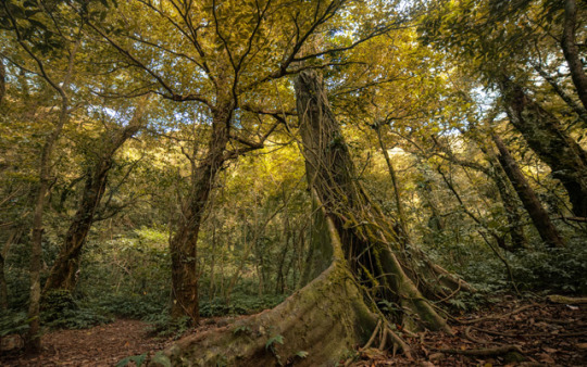
Mt. Pico de Loro is located in Cavite province, it grants climbers and visitors a breathtaking perspective of Cavite and the state of Batangas as well as the South China Sea. The elevation of Mt. Pico de Loro is 688 meters, or 2257 feet. It is Cavite's highest point. In the province of Batangas, the municipality of Maragondon contains the mountain's northern half, and the municipality of Nasugbu has its southern half. The monolith of Mount Pico de Loro is a 50-foot-tall solitary stone pillar that is located not far from the top. While climbing this monolith involves some bouldering and rappelling, once hikers reach the top of the rock peak, they can be proud of themselves. A spectacular and lifelong memory-making view awaits hikers as their reward.
Pico de Loro refers to "Parrot's Peak." It was rumored that the mountain received its name from its pointed peak, which from a distance resembles the shape of a parrot's peak and is regularly used by seafarers as a marker to turn in the direction of the east in order to reach the historic Manila Bay and Corregidor Island.


9 notes
·
View notes
Text
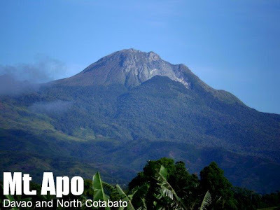
Davao del Sur
Entry point: Brgy. Sibulan, Sta. Cruz, Davao del Sur
Exit point: Brgy. Kapatagan, Digos, Davao del Sur
LLA: 7°0′30″N, 125°16′33″E, 2,956 MASL (#1)
Days required / Hours to summit: 3-4 days / 14-16 hours
Specs: Major Climb, Difficulty 8/9, Trail class 2-4
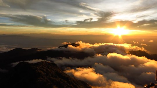
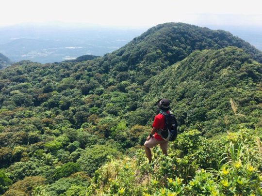
Mt. Apo, which towers above Southern Mindanao and covers the provinces of Davao del Sur and North Cotabato, is the tallest mountain in the Philippines. At 2,956 MASL, it has a diverse scenery that ranges from rugged rock formations to virgin woods, mossy bogs, and volcanic structures. In fact, Mt. Apo has the broadest variety of habitats and offers mountaineers an experience that meets their standards for the tallest mountain in the nation.
The Kidapawan trail leads to Mount Apo's summit, the highest point in the Philippines. The journey includes crossing the Marbel river on coconut logs, passing through Mainit Hot Springs, and reaching Lake Venado. From there, it's a 3-hour trek through a grassland to the rocky summit area, with wild berries and a water source. Climbers find the summit enchanting with its scenic beauty and exploration opportunities.
According to legend, Mt. Apo was named after a nobleman by the name of Apong who perished while settling the conflict between two potential husbands for his daughter Saribu. The term "Apo," which in Filipino means "master" or "grandfather," is another idea for the name's origin. Mt. Apo is unquestionably the patriarch of Philippine mountains.
7 notes
·
View notes
Text

Tanay, Rizal and General Nakar, Quezon
Major jumpoff: Brgy. Daraitan (village centre), Tanay Minor jumpoff: Sitio Cablao Brgy. Pagsangahan, General Nakar LLA: 14°36′48.5′′N 121°26′19.5′′ E, 739 MASL (+600) Days required / Hours to summit: 1 day / 2.5-4 hours
Specs: Minor climb, Difficulty 4/9, Trail class 1-3 Features: Tropical forest, limestone formations, river trek
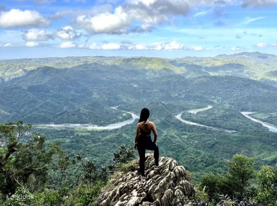
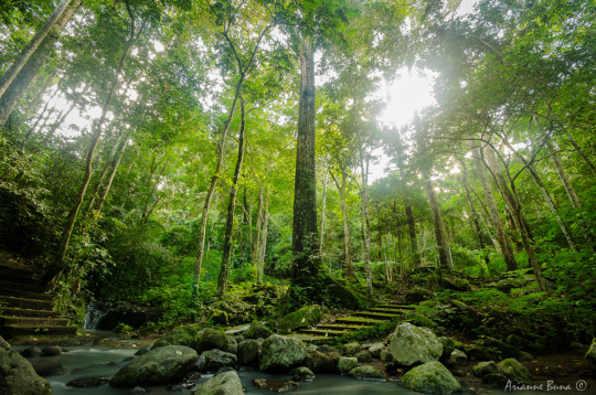
Mt. Daraitan is a gem at the heart of the great Sierra Madre mountain range which sits near the border of Tanay, Rizal, and General Nakar, Quezon. It offers a relaxing view like Daraitan river, sea of clouds, and picturesque Sierra Madre Mountain range. It is situated in Tanay, Rizal's Barangay Daraitan. Mt. Daraitan rises to a height of 739 meters (2,424 feet) above sea level. The area boasts the best that nature has to offer, from clear rivers and lovely caves—an approximately 100-year-old structure made of pillar and pebble rocks—to a great view of the Sierra Madre mountain range and the lovely Tinipak River. The hike up is a (mostly) straightforward 600-meter ascent that might feel steep to those not used to hiking. There are, however, plenty of holds and the trail is well-maintained.


7 notes
·
View notes
Text
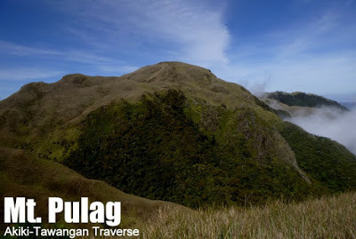
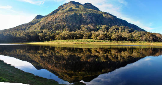
Kabayan, Benguet
Entry point: Akiki Ranger Station, Brgy. Doacan, Kabayan
Exit point: Brgy. Tawangan, Kabayan
LLA: 16°34’58″N 120°53’15″E, 2922 MASL
Days required / Hours to summit: 2-4 days / 9-12 hours
Specs: Major climb, Difficulty 7/9, Trail class 2-4
Features: Pine forests, mossy forests, Scenic grassland summit
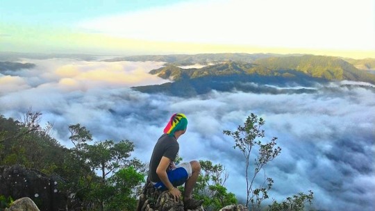
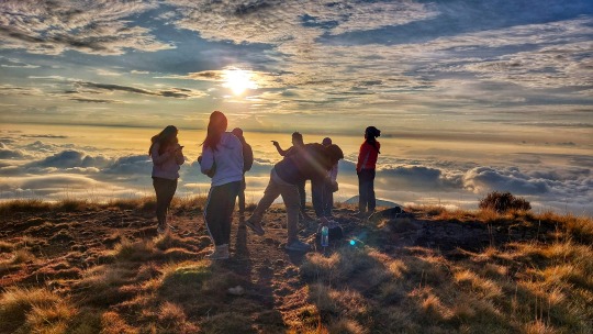
The tallest mountain in Luzon and one of the most stunning mountains in the Philippines is Mount Pulag. The height of Mt. Pulag is 2922 meters, or 9586 feet, above sea level. Both novice hikers and seasoned hikers love it as a destination. Additionally, it contains some of the most diverse ecosystems in the nation, with broad pathways flanked by pine trees, mossy forests, and grassland scenery. The mountain is also worthwhile to climb due to its difficult trails and stunning surroundings. Benguet's Mt. Pulag shares a boundary with the provinces of Ifugao and Nueva Vizcaya. More than 500 different plant species can be found on the peak. There are also some endangered animal species there. According to the local tribes, Mt. Pulag is the gods' playground. In a same vein, it is figuratively as close to heaven as trekkers can get.
Mt. Pulag offers a breathtaking view of the Milky Way Galaxy and is known for its sea of clouds, which draws tourists from all over the globe who want to take in the beauty. The Ambangeg Trail, Akiki Trail, Tawangan Trail, and Ambaguio Trail are the four distinct trails on Mount Pulag. While Ambaguio Trail is the longest and most difficult trail, Ambangeg Trail is the easiest and most well-liked trail among hikers.
8 notes
·
View notes
Text
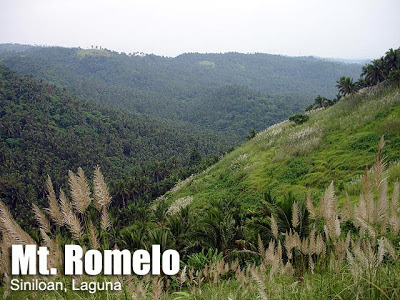
Siniloan, Laguna
Major Jump-off: Brgy. Macatad, Upland Siniloan
Elevation: 300 MASL
Days required / hours to summit: 1 day, 2-3 hours
Specs: Minor Climb, Difficulty 2/9, Trail Class 1
Features: Waterfalls, rain forest
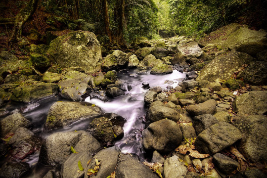
Mt. Romelo is one of the most visited mountains in Laguna province, It offers several waterfalls and breathtaking views of the Southern Luzon region. Mt. Romelo rises 984 feet or 300 meters above sea level. Despite having a lower elevation than other mountains in Southern Luzon, this peak has become a popular weekend destination for hikers of all skill levels. In the past, Mt. Romelo was also referred to as Mt. Kapaynutan and Mt. Famy.
Mt. Romelo consists of seven waterfalls namely Buruwisan Falls, Lanzones Falls, Batya-Batya Falls, Sampaloc Falls, Sapang-Labo Falls, Binaytuan Falls, and Diwata Falls. The famed Buruwisan Falls, which rise to a height of roughly 55 meters, is the tallest and largest of the seven waterfalls. The hardwood mixture that used to grow on the banks of the Siniloan River, it was claimed, is how the falls got their name. In contrast, Lanzones Falls, which is encircled by woods, is only 21 meters above sea level. The well-known Buruwisan Falls, which rise to a height of roughly 55 meters, is the tallest and largest of the seven waterfalls. The hardwood mixture that used to grow on the banks of the Siniloan River, it was claimed, is how the falls got their name. In contrast, Lanzones Falls, which is encircled by woods, is only 21 meters above sea level.

#Mt. Romelo#Hiking#Trail#Waterfalls#fresh water#Burisan Falls#Batya-Batya Falls#Lanzones Falls#Sampaloc Falls#Sapang-Labo Falls#Binaytuan Falls#Diwata Falls
17 notes
·
View notes
Text

Sto. Tomas, Batangas and Los Banos, Laguna
Entry point: Sitio Jordan, Brgy. San Miguel, Sto. Tomas Exit point: UP College of Forestry, Los Banos, Laguna LLA: 14.13°N 121.20°E, 1090 MASL (Peak 2) Hours to Peak 2 / days required: 1-2 days / 5-8 hours
Specs: Major climb, Difficulty 5/9, Trail class 3 with roped segments Features: Roped segments, rocky face, limatik, rattan, tropical rainforest
The Makiling Traverse (which we first referred to as "Maktrav" in 2008), invented by Sky Biscocho in the early 1990s, is still a well-liked dayhike. The height of Mt. Makiling is 1090 meters above sea level, or 3576 feet. It provides climbers with a thorough view of the Southern Tagalog mountains, including Mt. Banahaw, Mt. Kalisungan, Mt. Cristobal, Mt. Obabis, and Mt. Prinza, from the summit.
According to Dr. Jose Rizal’s writings in the year 1890 about the story and myth of Maria Makiling: Once upon a time in a place called Makiling, there lived a god and goddess couple. They have a daughter named Maria. Maria is a very beautiful maiden or fairy. Her beauty is captivating and any young man will be charmed by her porcelain complexion and shining eyes. Their family is known to be kind and helpful to others, especially those in need, which is why the people around them love them so much. In those days, the gods were given the power to mingle with the people. One day a charming young farmer saw Maria one day, and upon seeing her beauty, he fell in love with her. Since then, he has always looked forward to it. The young farmer is the envy of his fellow farmers since, thanks to Maria Makiling's care and protection, neither plague nor bugs have harmed his crops. The young man thus always ascends the mountain to meet and be with his fairy lover. They quickly developed a romantic relationship, which the girl's parents learned about. Because a goddess cannot fall in love with a mortal, Maria's parents promptly cut off contact with that man.
8 notes
·
View notes
Text
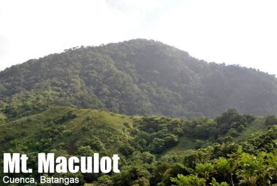
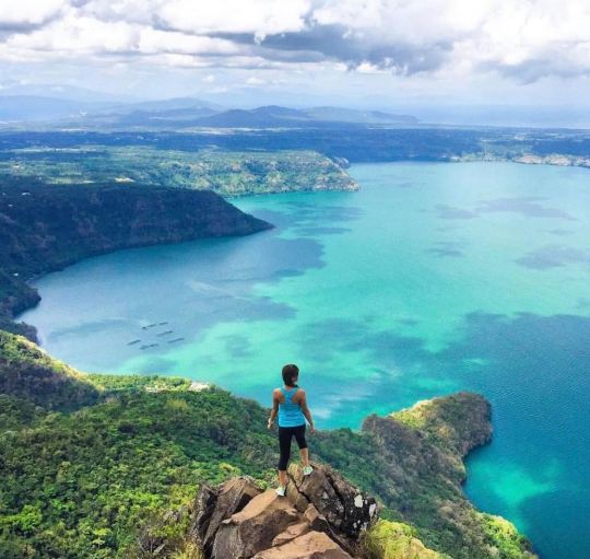
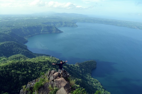
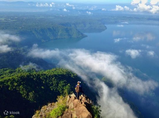
Cuenca, Batangas
Major Jumpoff: Mountaineer’s Store, Brgy. 7 “Siete”, Cuenca
Exit point (traverse): Brgy 5 (to Grotto), Cuenca
LLA: 13°55 N; 121°2 E; 706 MASL (Rockies) / 930 MASL (summit)
Days required / Hours to Rockies / summit : 1 day / 1-2 hr / 2-4 hr
Specs: Minor, Difficulty 3/9 (Rockies); 4/9 (Traverse) Trail class 1-3.
Features: Scenic views of Taal Lake, rock formations, forests
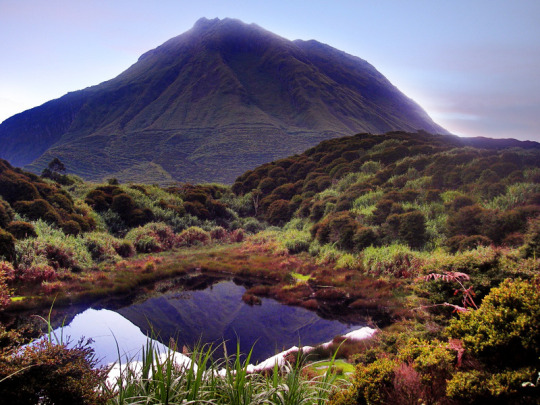
One of the top hiking spots in the Philippines is Mount Maculot. It provides sweeping views of Batangas's neighboring towns and the renowned Taal Lake. The top of Mount Maculot is 930 meters (3051 ft) above sea level. Mt. Maculot Rockies, on the other hand, is 706 meters or 2316 feet higher than sea level. Despite being less than 1000 meters above sea level, Mt. Maculot may be viewed from Puerto Galera and several locations in the province of Northern Mindoro.
Mt. Maculot is located at the heart of Batangas which is in the municipality of Cuenca, Batangas. This mountain attracts a lot of hikers and mountaineers on weekends and during the summer because of its proximity to Metro Manila. Today, Mt. Maculot is a significant tourist site, a dormant stratovolcano that is ideal for a day hiking excursion for hikers of all skill levels.
Mt. Maculot has a rock formation on top that overlooks the entire Taal Lake, including the Taal volcano, as well as the plains of Batangas, is situated next to Taal Lake. From a distance, Mt. Makiling and the Tagaytay Highlands can be seen on opposite sides. You can view Mt. Halcon in Mindoro if you continue south along Batangas Bay and pass Maricaban Island. It can take less than an hour for expert climbers to reach the Rockies, but it can also take up to two or three hours at a more leisurely pace. Due to the trail's popularity, some enterprising residents would offer drinks at the rest spots along the relatively steep trail, including buko juice.

6 notes
·
View notes
Text
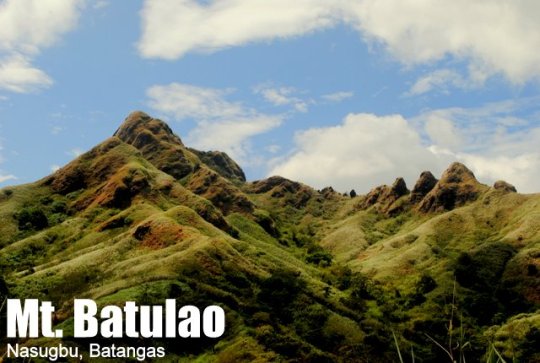
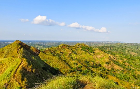
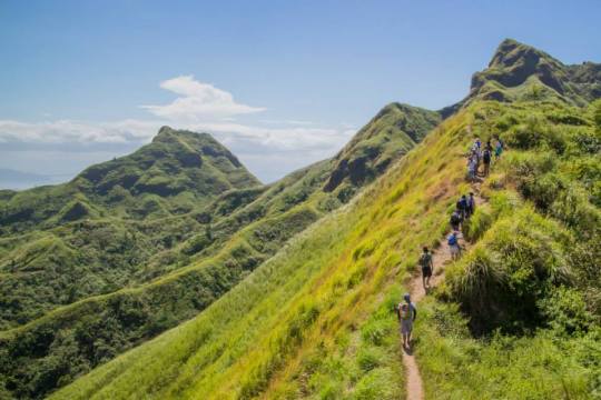
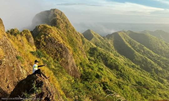
Nasugbu, Batangas
Jump-off point: Evercrest Golf Course, Nasugbu
LLA: 14.0408 N 120.8011 E 811 MASL
Days required / Hours to summit: 1 day / 2-4 hours
Features: Open trails, rolling slopes, scenic views of Batangas
Specs: Minor climb, Difficulty 4/9, Trail class 3 with 60-70 degrees assualt
Mt. Batulao's cool environment provides an enjoyable getaway from the city. On a clear day, it provides magnificent views of the terrain in Batangas and other adjacent provinces. The height of Mt. Batulao is 811 meters (2,660 feet) above sea level. It features established paths that are suitable for beginners and has a 4/9 difficulty rating. Its gorgeous rolling slopes and somewhat steep topography make it one of the coolest mountains to climb in Southern Luzon.
The name of Mount Batulao has a fascinating beginning. The word "yellow stone" is Batong Dilaw in Tagalog. According to legend, the mountain received its name because, on clear days, the early morning sun's rays would paint the slope yellow. Mt. Batulao's beauty throughout the year is more than enough to make it one of the most popular hiking destinations in the Southern Luzon region, even though this only occurs during the last week of December.
You will experience the same chill as Tagaytay visitors the moment you arrive at the Evercrest Golf Course, the jumpoff. And this temperature will follow you around, even in the typically dry and chilly months of January and February. On the other hand, due to the exposed aspect of its routes and its propensity for muddiness during the wet season (June to October), there are some days when Mt. Batulao can feel like a desert—extremely hot and humid. However, Mt. Batulao frequently receives gusts that make any trek, regardless of how hot or how cool, delightful.
8 notes
·
View notes