
Don't wanna be here? Send us removal request.
Statistics
We looked inside some of the posts by galileo-app-blog and here's what we found interesting.
Average Info
Notes Per Post
2
Likes Per Post
2
Reblog Per Post
0
Reply Per Post
0
Time Between Posts
2 months
Number of Posts By Type
Text
10
Photo
4
Quote
3
Last Seen Tumblr Blogs


Fun Fact
Tumblr Inc. is funded by 13 investors.
Text
Version 3.3.1 Release Notes
It has been a long time since we have release out last version of the Galileo app and even longer since the last post. We think it is about time to start this going again and get better at updating this blog!
So we've just rolled out a major update with several major new features and improvements.
Synchronise with iCloud & Dropbox
Now you can sync your Galileo data between all of your devices using iCloud or Dropbox. Keeping your GPS tracks and bookmarks in sync across all of your devices has never been easier. No matter what number of iOS devices you use, you can have all of your geo data easily available.
Your data will sync automatically from time to time if you're logged into the same iCloud or Dropbox account on all your devices (and if sync is enabled in app settings of course :).
In case of Dropbox you can initiate sync process manually: just pull the My Collections list down until spinning icon appear.
The exact amount of time to initially upload your data varies based on the size of your data and the speed of your device and internet connection.
Drag & drop between collections
Now you have no need to open item details screen every time you want to change the collection it belongs to. Finally! Just tap and hold the track or bookmark on My Collections screen and move it to the collection you want.
P.S.
We will continue to improve the app over time, and we appreciate any feedback you may have. You can send your thoughts at [email protected].
0 notes
Text
Beta Testers Wanted
Do you love Galileo and want to help us to make it even better? We are looking for enthusiastic and approachable folks to give us feedback on the Galileo app before it goes live. This will include finding bugs, translation typos, or any other improvement suggestions.
This is an unpaid role but you will receive Pro version for free with chance to preview Galileo’s some latest features among the first.

Interested?
Drop us an email at [email protected] with subject “I want to be a beta tester” and let us know a little bit about yourself :
What kind of device do you use?
What iOS version do you run? (iOS 8+ required)
Where are you located?
What languages do you speak?
How often do you use Galileo? How do you use it?
0 notes
Photo

MGRS coordinates in #GalileoApp. #comingsoon
0 notes
Text
Offline vector maps
The last year has been a remarkable year for our small team.
There were 14 (!) versions released last year and we want to thank you for your support, feedback and encouragement!
The biggest milestone of the year — version 3.0+. Just before the end of 2013, after a year of hard work, we launched our own vector maps in Galileo app. Ta-dam!

The process of creating the vector-based maps wasn’t easy. Our main goal was to deliver the fast, compact, rendered on the fly vector maps to our users.
There was a lot of learning, effort and persistence that helped us to finish the work we started. Looking back through the time, end result is worth the effort. Now it's possible to download country map files before a trip for offline use directly within the app and zoom in without losing any detail between levels.
What's now? We not only want to keep our vector maps the fastest and most lightweight offline maps on the App Store, we also see it as a strong foundation to deliver many more features in future versions.
Now we are working on new v3.1 that will bring more countries and more newly added surprising features, so keep your eye on us at:
Facebook | Twitter | Instagram
0 notes
Photo

New option to change the color of gps track according to speed or altitude in v3.1. #comingsoon
0 notes
Quote
Galileo Offline Maps is a powerful offline map application offered for free in the App Store, Galileo Offline Maps can help you find your way when you aren’t sure of where you are, discover new things along the way, and even plan a travel itinerary. The wide range of features that are available on the app make it a popular one to use when you’re lost, as well as one that can be used in everyday life.
Paul Schaecker
0 notes
Photo

Sneak a look at new app design. #ComingSoon #GalileoApp #v3
0 notes
Text
Editing a map has never been easier
OpenStreetMap (OSM) — the free and editable map of the world. It's completely created by crowd and free for anyone to contribute. You can use it to add and update data in your area, making the map better for everyone. Edits that you make on this map will be visible to everyone who uses OpenStreetMap, including the Galileo Offline Maps users.

First of all, you need a computer connected to the Internet and some time to gather information to contribute to the map.
1. Join the OSM community
In order to make an edit, you need a free OpenStreetMap account and agree to share your contributions under OpenStreetMap's license*: http://www.openstreetmap.org/user/new.
*This ensures that the data stays free for everyone and that changes can be attributed to specific sources.
Congratulations, you are now a member of a very large community of contributors to OpenStreetMap!
2. Collect data
The best source of data is your local knowledge, when you simply know the area you live in very well: e.g. the names of the roads and streets, which shops or buildings there are, other local points of interest, or whatever else you might want to add to OpenStreetMap.
The most commonly mapped features and the way to describe them in OSM can be found on the map features page: http://wiki.openstreetmap.org/wiki/Map_Features.
3. Start mapping
Open the http://www.openstreetmap.org and navigate the area you want to edit.
Then click Edit (or select "Edit with iD (in-browser editor)" option inside the "Edit ▼" menu).
There is an aerial imagery from a Bing source as background by default.
Start the walkthrough tour via the bookmark icon on the right side-panel:

4. Make edits
Make your first edit. For example, add missing house numbers or other info to existing objects on map:
Select an object on a map.

Enter the lacking details or add tags at left panel shown for highlighted object.
Click "Save" button to finish a group of edits.
Enter a short comment explaining the change you made, and click 'Save' again to post the changes to OpenStreetMap server.

5. See results on map
Congrats! You've made your first contribution to OpenStreetMap and now it's time to see it on the map.
Your edits will appear on OpenStreetMap main map —just refresh the map in 10-15 minutes here to see your changes: http://www.openstreetmap.org/.
Here you will find more details on how to contribute to map: http://wiki.openstreetmap.org/wiki/Beginners_guide.
6. See results within the app
As your changes appeared on OSM, you might want to see them within the Galileo Offline Maps app.
There are two ways to update previously cached tiles on your device:
First. Go to app settings and select "Cache Info" menu from list, then enable "Map Refresh" option and set the slider value to "always refresh" (left boundary) position. Back to map and navigate the area with changed map when being online to re-cache the map. Do not forget to disable "Map Refresh" setting when you finished.
Second. Go to app settings and select "Cache Info" menu from list, erase the whole cached map for OpenStreetMap source at once. In this case you will lose all saved OSM tiles and need to save them again by browsing the map manually while being online.
Hope this cheat note will encourage you to be a cartographer and make the OpenStreetMap better.
0 notes
Text
Version 2.6 Release Notes
Just to tell you quickly about the several new features available sinсe the latest v2.6 released.
First of all, trip monitor panel was added to display your current speed, altitude, distance and duration while moving:

Read more here: http://galileo-app.com/help.html#monitor
Second, previously "secret" handy tweaks are no more hidden. Just go to system Settings, scroll down and find the Galileo in list:

This allows you to adjust the app settings to adapt your device to your specific way of use:
Adjust for use in China,
Allow overzoom on map,
Cluster bookmarks.
We hope that you really like what we’ve done. So, tell us what you think and leave us a comment.
1 note
·
View note
Text
Get turn-by-turn directions into Galileo Offline Maps
Galileo Offline Maps provides many benefits to travelers: from being able to save on roaming costs while traveling to using their favourite map sources like Google or Bing Maps. But one of the biggest advantages is saving you from getting lost. Here's how to use the Google Earth to get driving directions for your next trip and upload to Galileo Offline Maps.
Get route:
Begin by downloading Google Earth tool for desktop: http://www.google.com/earth/download/ge/.
Launch the app (get acquainted with basic features user guide).

Click "Get directions" link to reveal the fields for entering start and ending points for your trip:
Enter the address you're traveling from (A) and address you're going to (B) and click "Get Directions" button beneath the fields.
When you get driving directions between two points, those directions are listed below and line indicating the route appears on map.

You can also search for a specific address, or place pin on map manually: right click on any placemark will appear the context menu with "Directions from here" and "Directions to here" options:
Save route:

To save route with turn-by-turn directions, copy the driving instructions to "My Places" folder by clicking the icon as shown below:

Find the saved route in "Places" section, select it and open context menu on right mouse button click, click "Save Place As..":

Save as KML file on your computer (not .KMZ): Once that's done, new file with .KML extension will appear on selected folder on disk, available for upload into Galileo Offline Maps app.
Import route into the app:
One more step to complete a quest: import .KML file into the app in on of the following ways: via DropBox, weblink or email attachment (please read more here).


Here's how to import your route from Dropbox using the "Open in.." option:

Hope, it will help you to navigate through unfamiliar roads and not to get lost. Keep your eyes on the road and have a safe trip!
0 notes
Text
USGS topographic maps on your iPhone & iPad
The USGS announced the other day that topographic maps from The National Map are now freely available for viewing by iOS users on their mobile devices, "leveraging USGS maps together with the power of GPS to zoom in on their precise location while hiking, biking, running, or any other activity that benefits from precision navigation".
We have prepared these links to make it easier to add USGS map sources into the Galileo Offline Maps:
USGS National Map - Topo
USGS National Map - Satellite
USGS National Map - Vector
Note: map download speed can vary and depends on the speed of your Internet connection and the speed of the server from where the map is downloaded.
Read more: "USGS Topo Data on the Go".
0 notes
Text
How to import your Foursquare lists into the Galileo Offline Maps
Want to have all your Foursquare lists imported to Galileo Offline Maps in one tap? If so — you will want to take a look at the following service: Foursquare Lists KML Export.
Follow these simple steps:
Open http://geoklubb.se/foursquare-lists-kml-export on your iOS device:

Connect to Foursquare to see your saved lists:
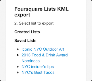
Tap the list you want to import.
Select "Open in Galileo" option in browser*:

As a result, a new collection with bookmarks will be added to the app:

*Galileo Offline Maps app should be installed on your device to have this option.
It's a nice little feature lets you visualize your saved places on a map, so that the next time you're offline you'll still be able to view them within the Galileo Offline Maps.
/With thanks to Fredrik Davidsson for the tip!
What do you think of the “Foursquare Lists KML Export” tool?
0 notes
Quote
"Having used just a couple of offline maps app before, I thought this was going to take me sometime before I figure out what it has to offer. But it’s more or less intuitive and I am guessing that even if you are using offline maps for the first time, Galileo would be super simple and easy to use."
Galileo Offline Maps App for iPhone & iPad: One of the Best Travel Companions on iGeeksBlog.com
0 notes
Text
Spilling the beans
Galileo Offline Maps is a map browsing app that saves a map tiles to view them later — offline and really fast.
Good news for those who used to use the most popular map sources such as Google Maps and Bing Maps and miss them within the app — now you can add them yourself.
Just open these links on your iOS device and select "Open in Galileo" option in Safari:
Google Maps (HD)
Google Maps — Satellite (HD)
Bing Maps
Bing Maps - Bird's Eye
OpenSeaMap
As a result, new map will appear in "Map Source" list available for viewing and caching even in a free version.
Enjoy using it and do not forget to tell your friends about this awesome feature!
* Map in hight quality looks great on the retina, but loads large tiles and requires twice more space for storing.
---
Cheers,
Galileo Offline Maps team.
1 note
·
View note
Text
Version 2.5 Release Notes
Today we have released a new version 2.5 of Galileo Offline Maps. We are delighted to deliver to you the Facebook integration.
Now you can share your geodata with your friends on Facebook in one tap:

Be the first to surprise your friends and family — share the bookmark or recorded GPS track from your latest trip, so they can view and take the same route.
To get started, logout from your Facebook account in device Settings and Facebook iOS app, then go to the Galileo Offline Maps and tap the "Share on Facebook" cell. It will ask you to login and permission to use your Facebook account within the app.
p.s. Do not forget to Like the app page at Facebook: www.facebook.com/galileo.offline.maps
0 notes
Quote
Fast, intuitive, rock solid. Offline map capability is great and there is flexibility in the way map information is collected.
by user FTP ML, Australia
0 notes
