
Don't wanna be here? Send us removal request.
Statistics
We looked inside some of the posts by garyringrose and here's what we found interesting.
Average Info
Notes Per Post
0
Likes Per Post
0
Reblog Per Post
0
Reply Per Post
0
Time Between Posts
4 days
Number of Posts By Type
Text
17
Last Seen Tumblr Blogs


Fun Fact
Tumblr has a low social media market share in South America.
Text
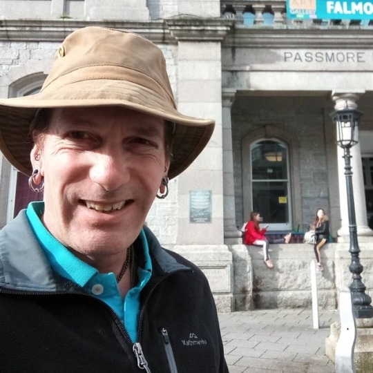
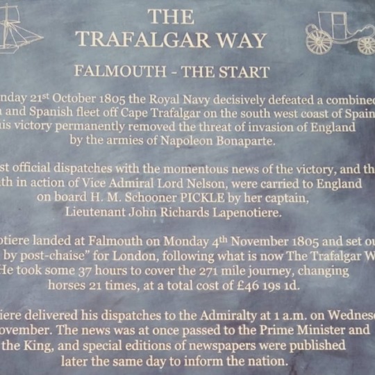
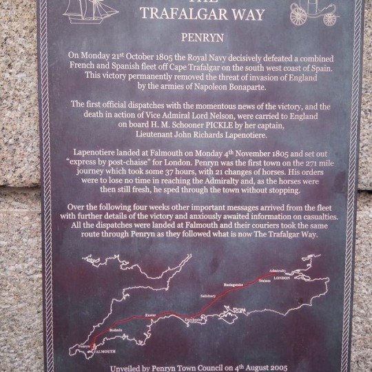
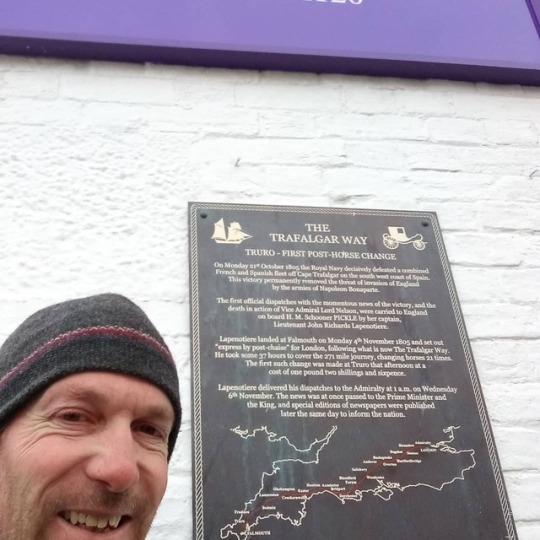
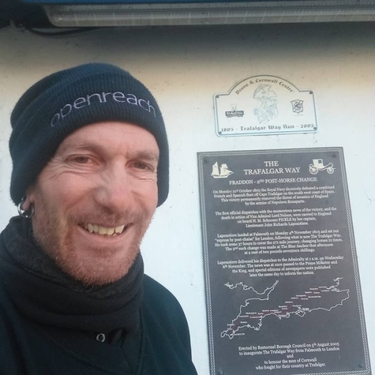
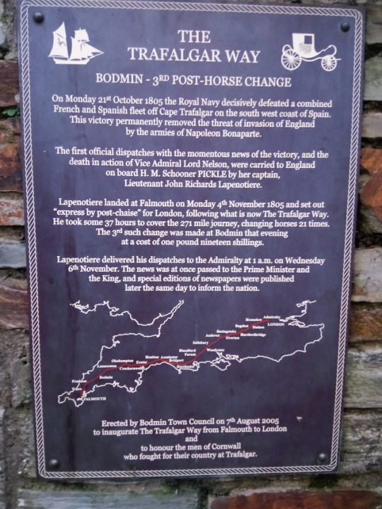
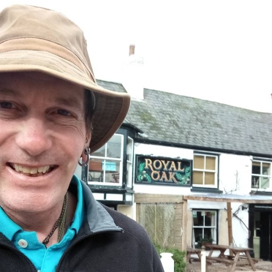
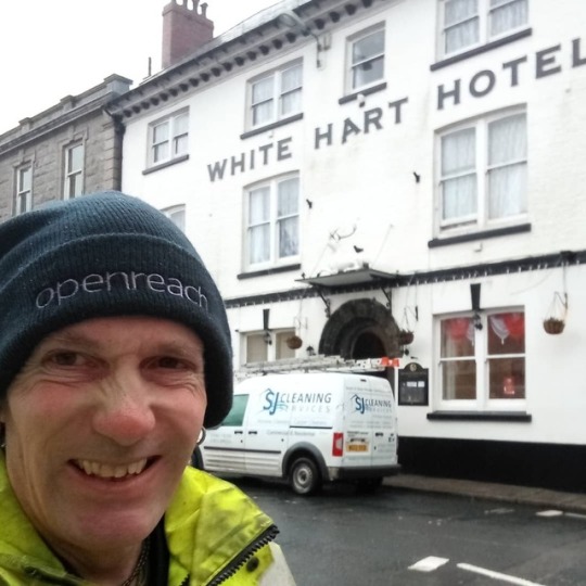
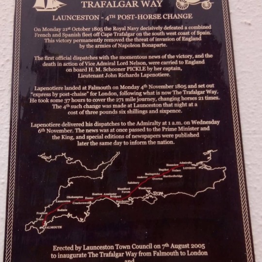
The Trafalgar Way 9-2-19
So a few weeks back when visiting Bodmin and the Jail I stumbled across a plaque in the town for the 200th anniversary of the Trafalgar Way. Never heard of it. Turns out in Nov 1805 the Cpt of HMS Pickle arrived in Falmouth with the news that England had won the battle of Trafalgar and Vice Admiral Lord Nelson had died. He personally took the news to the Admiralty in London via postal carraige along what is now known as The Trafalgar Way. The cost of the trip was £46 19s 6d and took 37 hours to cover the 271 miles , changing horses 21 times along the way.
In 2005 plaques were erected at various coaching Inns along the route to commemorate the event. There are 39 plaques in total.
Well I thought if I’m working in the area i’d see if I could spot some. So since Bodmin I’ve now been to all of the Cornwall ones: Falmouth, Penryn, Perranwell Station, Truro, Fraddon, Bodmin and Launceston.
I wouldn’t mind walking/cycling the route one day but I think a lot of the old route is now along some of our major roads so sounds a bit dangerous. Anyway here’s the Cornwall ones 😎
0 notes
Text
Trelights Area, Cornwall 9/1/19
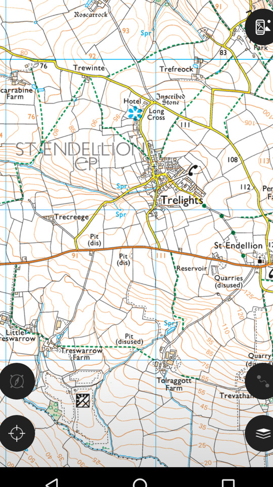
So today I was working at Little Treswarrow which is just above the top black disc, bottom left of above map section.
As you can see from the contours the area has fairly rolling hills and valleys with lots of streams and a lot of hard ground as a few quarries about the area.
The North Cornish coast is only a couple of miles due North with the nearest large village being the fishing harbour of Port Issac. This is a real old fishing harbour and is now more well known thanks to the singing group 'The Fisherman's Friends' and as the filming location of 'Doc Martin's the TV series starting Martin Clunes.
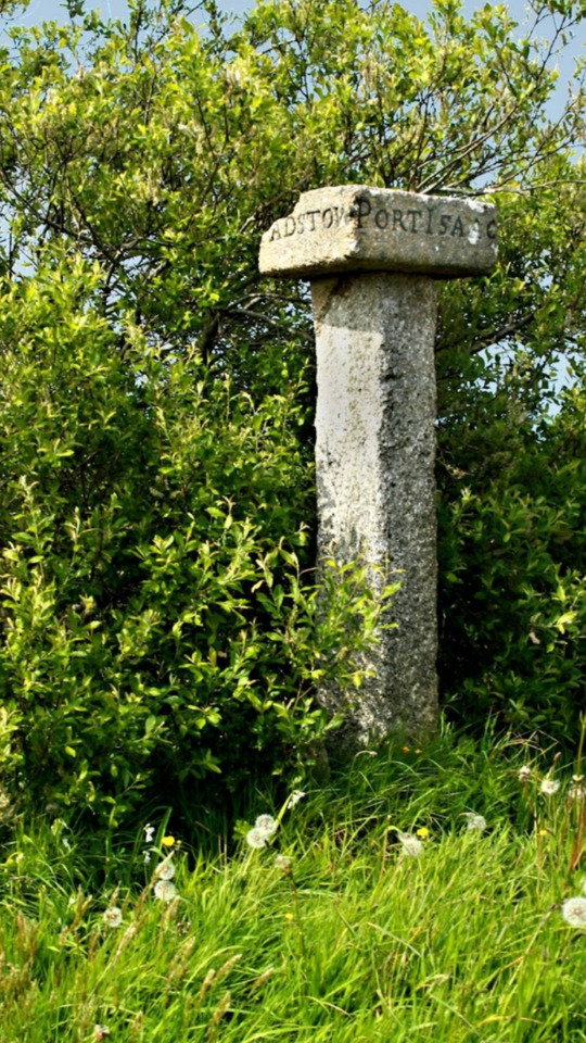
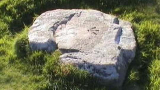
To the North and East of where I was working is the village of Trelights. There you can find a really old Long Cross direction stone indicating the way to Padstow and Port Issac (see picture below)
To the South East of Trelights is the village of St Endellion with it's parish church.
St Endellion is the type locality (where it was first discovered) of the mineral Bournonite and Barstowite.
To the NNE of Trelights is the farm of Roscarrock. This is a very old farm that is mentioned in the Doomsday Book. Apparently it's only been farmed by four different families since it's existence.
There's a lot of public footpaths and rights of way on the map section and looking at them I'd say a lot of them were old postal routes from farm to farm in the area before roads and transport.
0 notes
Text
Lanlivery Area 3/1/19
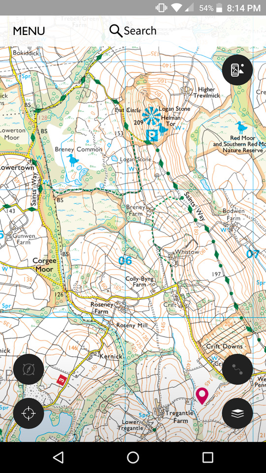
So today I was working at Tregantle Farm, near Lanlivery (Pink Pin).
A quick look on the map and as you can see North of my position by about 2.5km is Helman Tor. This is a Tor in mid Cornwall and is listed as a Nature Reserve, a scheduled ancient monument and a County Geology site. It's also next door to Redmoor site of special scientific interest. It forms the Northern end of a granite ridge and there is evidence on site of a prehistoric Hill fort and a stone circle hut settlement. There is also a Logan stone on site. This is a large stone balanced on another one that can be rocked by hand due to the balance point of the top stone.
You can also see from the map that Helman Tor is where the Saints Way walk splits direction. The path starts at Padstow church on the North coast and finishes at Fowey church on the south coast. At Helman Tor, one route goes via Lanlivery and Golant and the other goes via Luxulyan , St Blazey, Par and Gribbon Head. This is an old Pilgrims walk from coast to coast of mid Cornwall and is approximately 26 miles long. I have walked the Lanlivery route twice, once in one day and the second time with a bigger group of friends over two days.

Above pic of Helman Tor
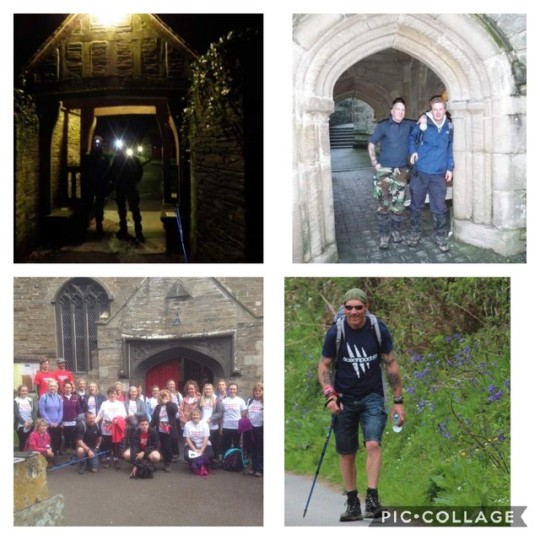
Above, top left outside Padstow church and top right outside Fowey church in the one day walk. Bottom left with the group at Padstow church and bottom right, on route to Fowey on the two day walk.
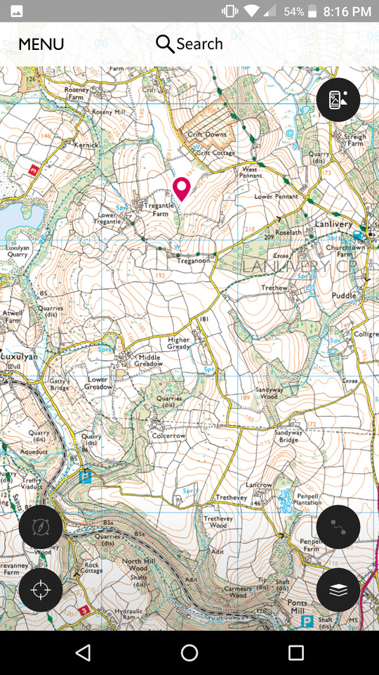
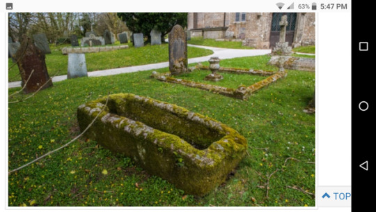
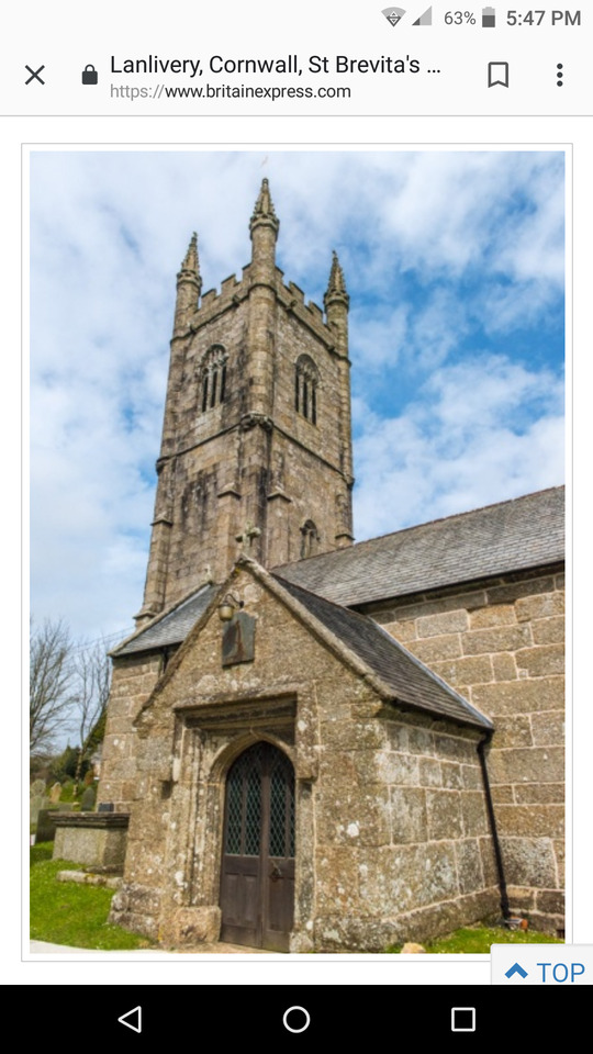
On this map , Lanlivery church is just to the East of where I was working. The present church dates to the 15th century with the granite tower added in the 17th century. This tower is 100ft and is the 3rd highest in Cornwall. The top used to be painted white to act as a daymark for ships at sea heading into Fowey harbour. In the Churchyard is an interesting Norman stone coffin.
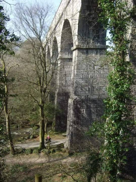
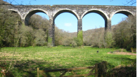
On the second map you can see Treffry viaduct marked just above the top round black icon, bottom left of map.
I know from personal experience and getting a telling off that the committee in the area didn't take kindly to me abseiling off this structure. I didn't actually know it's listed status beforehand to be fair and just saw it as something high and cool to abseil off.
This was a dual purpose bridge and carried a water stream to feed a waterwheel and it also carried a tramway completed in 1844. The flow of the water was used to turn a waterwheel 10m in diameter which in turn enabled mining loads to be lifted up the incline. It was all part of an ingenious system linking Par harbour, Fowey Consols mine (on Penpillick Hill) and a station in Bugle. The viaduct is approx 100ft (30m) high and 650ft (198m) long. It's a real interesting place to visit and is designated a World Herritage Site, is listed as an ancient monument and is also listed on Heritage England's list of heritage at risk due to it's poor condition.
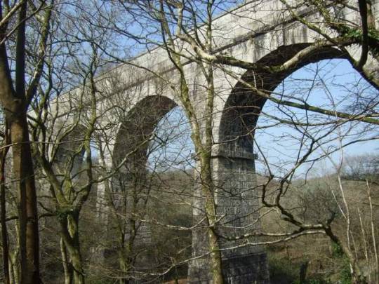
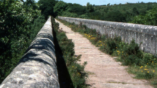
The picture above shows where the tram would travel, below the granite slabs (like railway sleepers) the aquaduct still flows.
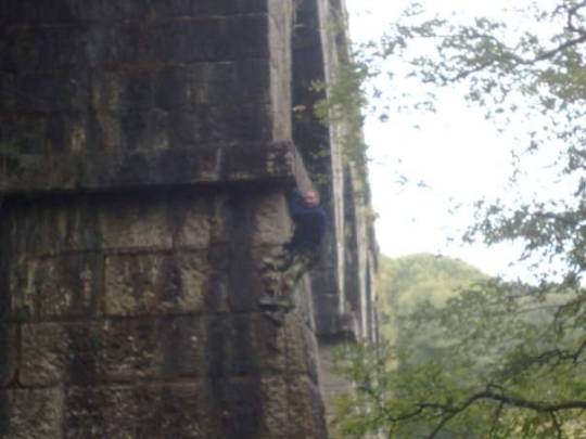
Above , me abseiling a World Herritage Site and scheduled Ancient Monument, sorry.
0 notes
Text
31/12/18 Penhale Farm
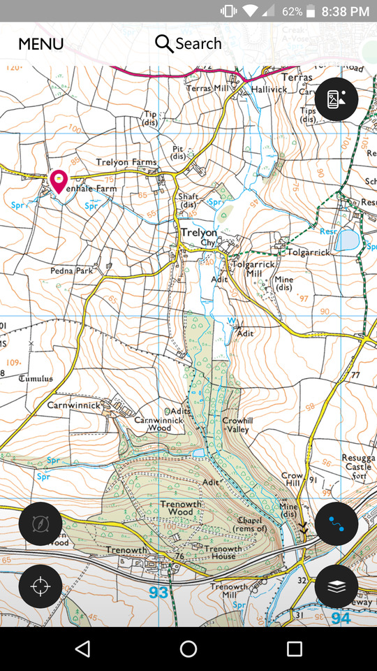
So for the last day at work of 2018 I was working at Penhale Farm. This is just to the North of Grampound Road village .
From the map section above their are quite a lot of interesting places around this area within a couple of kilometers.
Top right of the map you can see Terras Mill, there are two further Mills as you follow the course of the river Fal south, the first being Tolgarrick and the second at Trenoweth. These were all water powered Mills taking feed leats and exits to the nearby river. I think they were mainly for milling grain.
On the map, to the right of Tolgarrick Mill is the site of South Terras mine. This was one of the largest mines in the country for the extraction of Uranium! The nearby adits are all gated with warning signs of the dangers of radiation exposure so I wouldn't recommend exploring them!
There was also another mine at Crow Hill (bottom right of map). This was a mine that was primarily used for the extraction of Lead. There was also a large seam of Blue Elvin which is an increably hard and dense stone used in road construction.
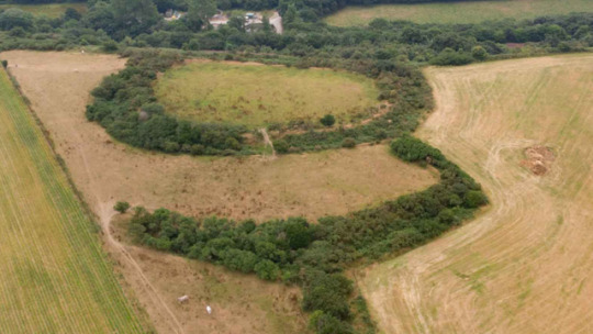
Just behind Crow Hill mine is the site of Resugga Castle. It's a castle from the iron Age and commands great views at the top of the hill looking down the Fal Valley. You can quite easily still see the footprint of this castle and it's moat if you visit the site.
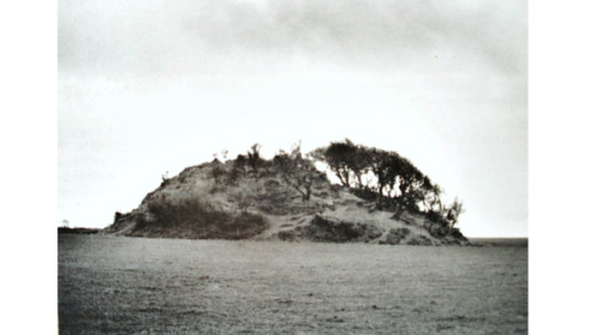
Due South of my work site (Pink Pin on map) is a Tumulus. These are very old buriel sites. They were usually built over a grave site and usually consisted of a stone like tunnel with a roof like slab stone and then the whole thing is covered over in earth. Examples that have been excavated have contained urns with cremated remains, bones and artifacts.
Below is Carne Tumulus, nr the village of Veryan in Cornwall. This gives an example of the looks of a Tumulus. This one in particular is one of the largest in the south of England. They vary hugely in size and some only have a slightly raised footprint on the ground as in the past farmers sometimes dismantle them to make full use of the field/land (I'm guessing this was before they became protected).
At the base of the map section running West/East or vice versa is the main line Great Western Railway linking Cornwall to the rest of the UK rail network. There's a pretty impressive viaduct to the East of Trenowth Mill that spans the Fal Valley.
Well there you go, all that in such a small area.
Happy New Year 😎
0 notes
Text
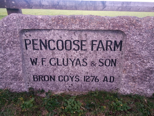
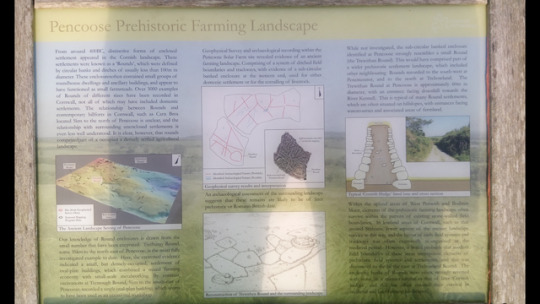
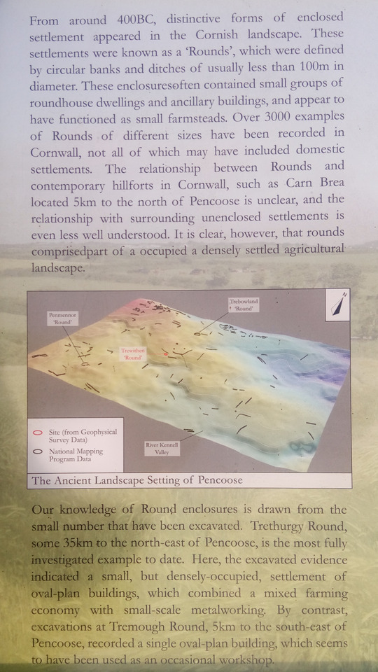
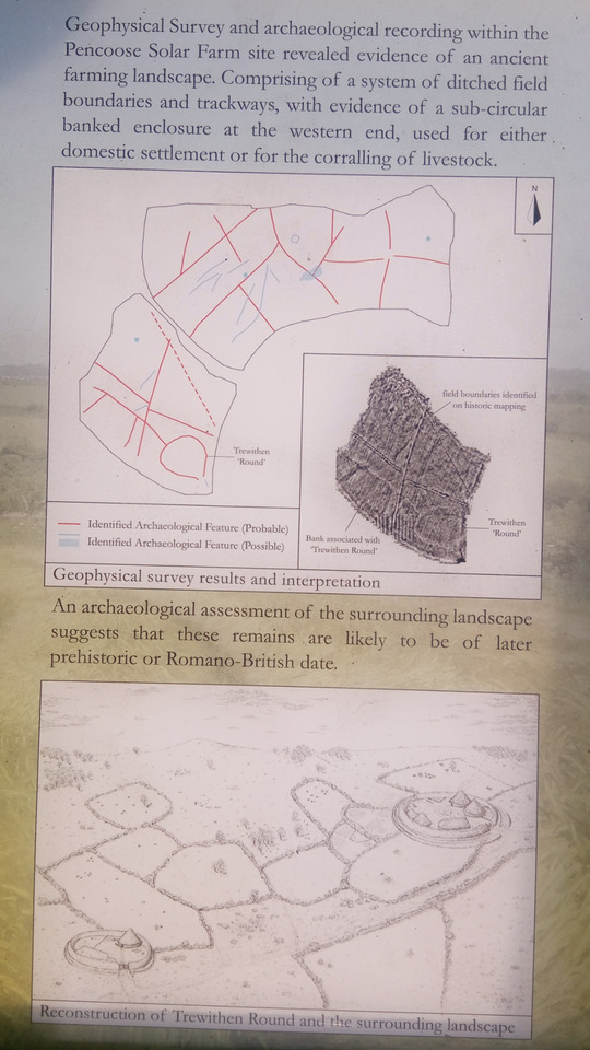
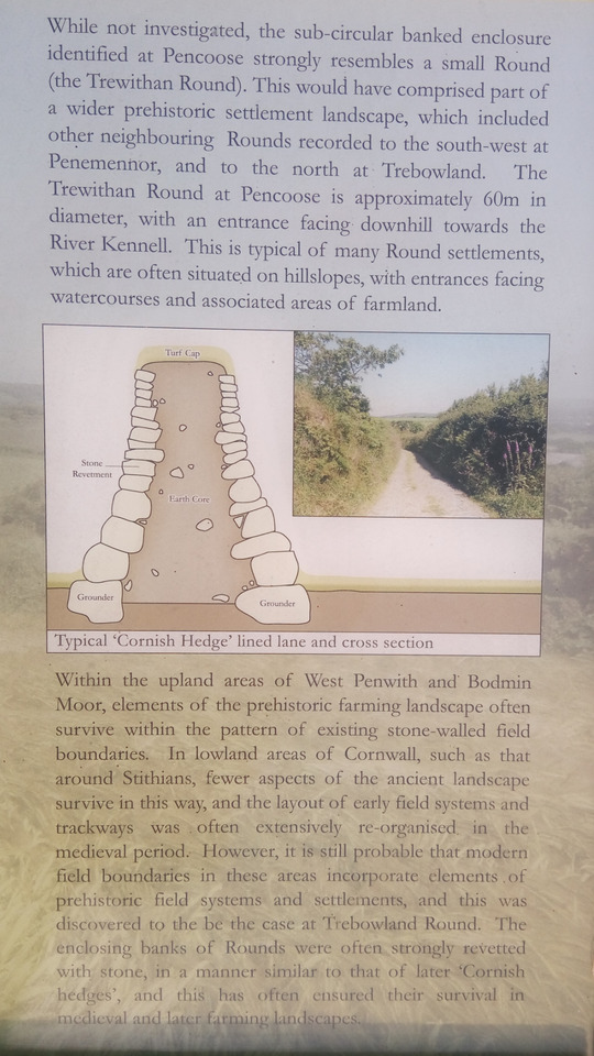
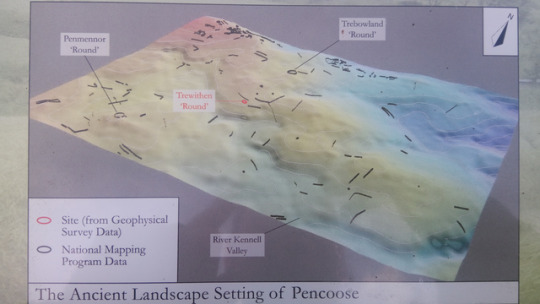
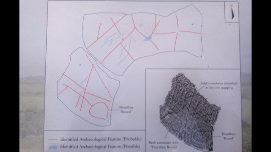
20/12/18 Pencoose Farm
Ok so today I was working in the country lanes between Stithians, Comfort and Ponsanooth (approx SW 7376 3887).
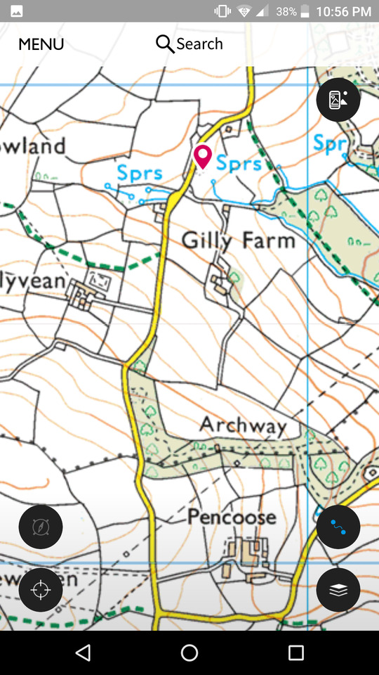
This was just North of Gilly Farm. My work colleague drove south down the road to turn around and informed me of a sign he'd seen that looked interesting at the entrance to Pencoose Farm.
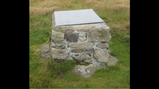
On completing our work for the day we decided to check it out. I'll let the text in the photos tell the story as it explains all the details. I've never worked in this lane before and although I checked the os map to see what was nearby, this site isn't mentioned. I believe it may have been bought to the fore when the fields containing the site we're surveyed for the now installed solar farm. 😎
0 notes
Text
19/12/18 Castle An Dinas
Well it seems a fair few of you enjoyed my blog regarding my recent travels in Bali and New Zealand and passed comment that you've missed seeing and reading them.
I'm gonna going to keep the blog going with all the future plans and adventures I'll be undertaking but as these don't happen every day or even every month I thought I'd try and do a daily post about something local in the area that I'm working at on that day. As I work outdoors all day I get to see some wonderful sights and some of the lesser known ones as well. So here goes with the first one 😎
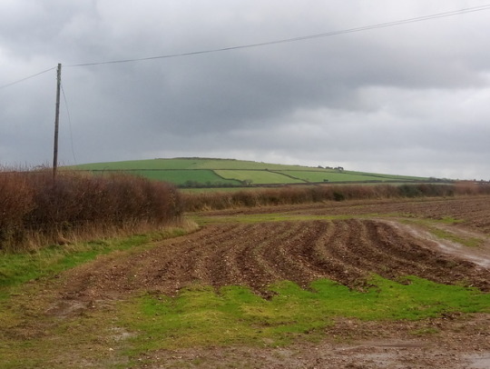
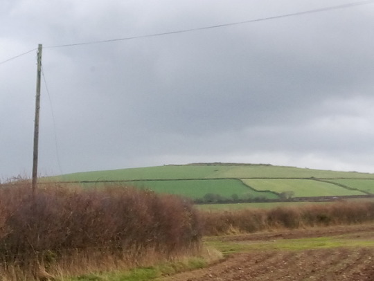
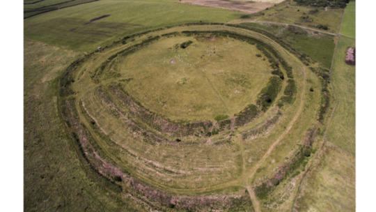
On the Apex of the hill in the middle distance of the photo is a site called Castle An Dinas. It's an Iron age hill fort in mid Cornwall (SW945624).
It's one of the most important hill forts in the south of Britain and consists of three ditch and ramparts in concentric ring formation. It dates to 2/3rd century BC and is 850ft/260m above sea level.
It is linked to King Arthur and it is said he used to ride with the local hunt here. Apparently Gorlois the Duke of Cornwall at that time also died here. There are historical tales of Ghost Armies appearing over the sight as well, with moonlight reflecting off the soldiers muskets.
In 1671 John Trehenban murdered two girls from nearby St Columb Major. He was sentenced to be put in a cage atop a stone at Castle An Dinas and starved to death. He begged a passer by for food but they only had tallow candles apparently and he ate them like a Savage when she gave them to him. The stone that the cage was placed on can still be seen and locally a no-gooder is know as a right Tremmon (how Trehenban is pronounced).
The above picture is of the stone at Castle An Dinas on which Trehenban's cage was placed and where he starved to death
Below is the stone as seen now. The viewpoint information board and plinth have been built on top of it which is a shame. You'd have thought they could have put it to one side or the other so that you could see this piece of history.
In 1904 a young woman called Jessie Rickard was murdered at the sight by a jealous lover who then took his own life.
From 1916 to 1957 the area was mined for Wolfram and the remains of some of the buildings and workings are still visible. It's also the place where the mineral Russelitte was first discovered. Where a mineral is first discovered is known as a type site. I guess they study the geology of the area of discovery so that if they find similar geology elsewhere, they may expect to find similar metals, minerals and precious stones. Wolfram/wolframite is the main source for the metal Tungsten. This is a very hard and dense metal that's used for armour piercing ammunition and also for strengthening the leading edges of tools and cutting machines. It was mined a lot in the WW2 era for obvious reasons.
I personally visited the site for the first time earlier this year. It's a great place to walk around and if you have brilliant weather it's a great place for a picnic (leave no trace, respect the environment and take your litter home) and the views are stunning. You should see some local birds and other wildlife in the area as well.
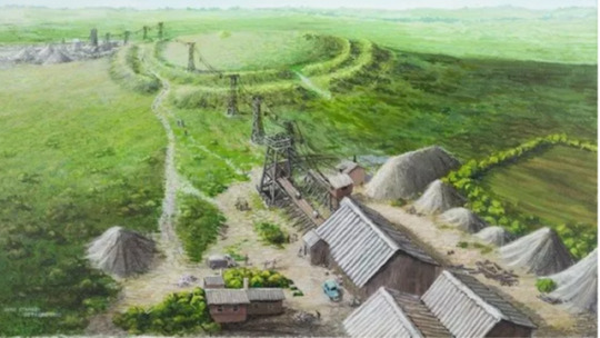
Above are ariel pictures of the current site and a drawing of the site with the Wolfram mine. Pictures taken from the internet.
0 notes
Text
Great TV Series
Check out the BBC iPlayer for this great series of river walks . I started with the westcountry Dart & Exe and then the River Severn. The Lea, Stour, Itchen, Hodder, Tees, Nidd, Dove/Soar/Trent and Deben to be going on with. Rivers are such magical places for the scenery, history, wildlife and locals that live their 😎
0 notes
Text
Great story, always new stuff found about the River Thames.
Menu
Who is man in the mud? Mystery of booted skeleton found in River Thames
15:46, UK, Tuesday 04 December 2018

Image:The skeleton was found in mud along the River Thames. Pic: MOLA Headland Infrastructure
By Adam Arnold, news reporter
The "mysterious" skeleton of a man in thigh-high leather boots lying face-down in mud has been discovered along the River Thames.
He is thought to be around 500 years old and was found with one arm above his head and the other bent back on itself to the side.
Experts said he could have fallen or drowned and was covered quickly by the ground as it moved with the tide.
Archaeologists said he could have been a fisherman, a mudlark - a person who scavenges in river mud for items of value - or perhaps a sailor.

Image:His boots could date back to the late 15th century. Pic: MOLA Headland Infrastructure
The discovery of the skeleton was announced by Mola Headland Infrastructure which said: "Leather was expensive and often re-used at this time and experts believe it is unlikely that someone would have been buried wearing such a highly-prized item.
"The boots would have reached thigh height when fully extended therefore would have been ideal for walking out into the river and through the sticky Thames mud, so were perhaps waders.
"They were built to last: our conservators revealed that they were reinforced with extra soles and stuffed with an unidentified material (possibly moss) perhaps to make them warmer or improve the fit.

Image:Excavations are taking place to build a 'super sewer'. Pic: MOLA Headland Infrastructure
"This research suggests the person wasn't buried deliberately and the clues also indicate the owner may have made his living from the river, which could well have led to his untimely demise."
He was found at Tideway's Chambers Wharf site in Bermondsey, where excavations are taking place to build the 25km-long Thames Tideway Tunnel "super sewer" to stop pollution in the river.

Image:Experts said he could have fallen or drowned. Pic: MOLA Headland Infrastructure
The site is at a bend in the river downstream from the Tower of London, close to where the medieval Bermondsey Wall stood.
There is speculation the man could have been climbing the wall when he fell into the water.
Possibly the biggest clues about his life are deep grooves found on his teeth.
They were caused by a repetitive action like passing rope between his teeth as a fisherman might - which may also suggest that he made his living from the river.

Image:Deep grooves found on his teeth. Pic: MOLA Headland Infrastructure
Beth Richardson, a finds specialist at MOLA Headland, said: "By studying the boots we've been able to gain a fascinating glimpse into the daily life of a man who lived as many as 500 years ago.
More from London
Five Guys apologises to pantomime dwarves 'mocked by staff'
Maureen Whale: Police ask public for help as pensioner dies after burglary spree
Suspected robber charged after police shootout in Wimbledon
Met Police officer under criminal investigation for knocking down moped teen
Public should 'get involved' to help officers under attack, says Met Police chief
Man shot by police as officers swoop on suspected robbers in Wimbledon
"They have helped us to better understand how he may have made his living in hazardous and difficult conditions, but also how he may have died. It has been a privilege to be able to study something so rare and so personal."

Force leaders to debate on TV
More than 100,000 people have signed the petition - have you?
Posted in:
LONDON
Sponsored Links
Look Up Your Name to See If You Get a PPI Lump SumThe Daily Advice
Dubrovnik or Split? Browse the best hotels in CroatiaTelegraph Travel
People Born Between 1948 & 1979 With No Life Insurance Must Read ThisQuoteSearch
0 notes
Text
Got my Simon Reeve Tickets 😎
An Audience with Simon Reeve 🌎🗺️
Coming to Plymouth 7 November 2019!
Simon Reeve is an adventurer and New York Times bestselling author and TV presenter who has traveled to more than 120 countries making multiple award-winning TV series for the BBC. They include Caribbean, Sacred Rivers, Indian Ocean, Tropic of Cancer, Equator, Tropic of Capricorn, Pilgrimage, Ireland, Australia (Winner of the British Travel Press Award for Broadcast Travel Programme), Greece, Big Life Fix, and his two new series Turkey (2017) and Russia (2017). He has received a One World Broadcasting Trust Award for "an outstanding contribution to greater world understanding" the prestigious Ness Award from the Royal Geographical Society, and the Special Contribution Award at the Travel Media Awards.
An evening you would not want to miss!
🎫Tickets go on sale Friday 23 November at 9am.
0 notes
Text
Quireboys Saltash Nov 2018
Great night at Livewire Saltash with Tony Ringrose.
Stranger we're really good, looking forward to hearing more from them in the future, Ethyrfield were pretty impressive too, definite Alice in Chains influence their and The Quireboys were fantastic, Spike as charismatic as ever and what a great band he's got behind him too. Top night 😎
0 notes
Text
New Zealand vs Ireland on my arrival home 😎
Ireland you F****n beauties. Got chatting to a kiwi at top of Mount Eden before I left yesterday about all sorts. Bloody nice guy. Got onto the rugby. He gave all blacks ,. I gave Ireland by 7, whadda ya know. I know he's a man of his word and he'll be having a drink to me tonight 😎 cheers
0 notes
Text
Bali and New Zealand Day 43
Well journey home. The plane was 2hrs late leaving Auckland and had to be towed off the runway and back to the terminal. Better this way though than to have something go wrong in the air.
I had a window seat so sidewall to sleep against and slept ok.
On arriving at Dubai late we we're marched from this gate, straight to the next one via security. It was a real Sprint and hastle to be fair.
Straight off 17hr flight and onto the next 7hr. This flight was ok too and again I had a window seat.
I watched a couple of red bull films & some stand up comedy and watched the film bucket list on my phone.
3hrs before landing the flight attendant advised me my bag not onboard. I did wonder as the gap between the two flights was so short if they'd have time to move bags. They were not very apologetic and just advised to ask at arrivals Heathrow for next step.
Got Heathrow and advised bag would be couriered to me the next day. I could have waited 2 hours for the next flight to collect it but they wouldn't pay to change my train ticket!
So off to Paddington, quick lunch and train to Kernow which as I've said had a changed layout so no coach J as booked. It was a quiet train for a change and had plenty of seats anyway.
Re the flights I had some good views from the window. Two contrasts I liked we're the mountains between Iraq and Iran looked stunning covered in snow, the other was on the approach to Dubai for the transfer. It's miles and miles of sand, the local houses were like corals surrounded by stone walls, presumably for wind and sandstorm shelter. The coastline had lots if hotels, irrigated green land etc but the rest was sand and desert. I don't know much about the area but other than a fly & flop/beach holiday they're doesn't look like a lot to do.
0 notes
Text
Bali and New Zealand Day 42
Well today's the day. Last one in NZ until next time. My bags all sorted, up and showered. I had a message from the air b&b owner to say they accidentally scratched the side of the hire car when they left for work this morning. Let them know cost and they'll reimburse me. I did think at the time where I was asked to park was a little tight for anyone else to get past in their drive. I initially parked on the street then parked where advised as closer to room to sort bags. I was then going to re park on street but didn't.
Typical on the last day of returning the car!! This happened on my previous visit when on last day of no car issues we parked in a layby to look at an historical water station, a logging truck came past, flicked up a stone and smashed the back windscreen!!
Anyway on further investigation you couldn't notice the scratch much, I was grateful that the hosts were honest and let us know. I said nothing to hire company and they checked over the car and didn't say anything so all good.
As a note on hiring cars here. Your covered for 3rd party/public liability in the hire cost. You can then pay extra to reduce the excess Gold, Silver or Bronze. On both our trips we've gone for gold which gives you a zero excess. It nearly doubles hire cost but gives piece of mind and even with cost it's still a reasonable daily rate. Without any excess package you can have to pay up to I think it was about £1,500, maybe more.
So first stop of the day unfortunately was to the domestic airport terminal to drop Heidi off as she was flying back to Southland for another 2 weeks travelling with her sister. Really weird to have been travelling together so long and then one of you is missing.
I then had about 9/10 hours before my flight so wasn't going to sit in an airport all that time to then sit for 17hrs on my first flight!
Decided to go into Auckland to find a Bivouac store as they stocked the boots I'd borrowed for the Taranaki climb. I was told by my guide they're awesome boots for hiking the hills and also hiking up mountains in snow with crampons. My own hiking boots are pretty old now and way too soft in support and the sole for snow/crampons. Did some online research, all rave reviews etc so decided if going to get new boots I'd go for some I know are comfortable (as used on Taranaki) and that had the option for crampons as would like to do snow hiking/climbing again. They would also be a great boot for the GR20 Corsica walk in 2019. Went to first store but they didn't have any. The store assistant was super nice and rang one if the other two stores in Auckland and tracked a pair down.
Lucky for me it was in an area easy to get to and park.
Anyway lots of foot measuring and advice, job done (the shop assistant their even had a pair!).
I was now peckish and broke so had to busk on the street for my lunch! Nah it was all good.
I did get a sandwich and drink and like always when I'm in an unformiler place I checked out Google maps.
This drew me to Mount Eden. This is Aucklands biggest volcano apparently. It's extinct and has great views of the city. Only about a mile and a half away, off I walked. The views really are stunning as is the old crater which is now covered in grass. It's like a park now and I'd imagine it gets grate sunrise and sunsets.
I got talking to a real nice kiwi chap , talked about lots random stuff and eventually the rugby. Told him I support Ireland and as they playing the all blacks the next night we had friendy bet on the out come. He went all blacks by 10, I went Ireland by 7 (and whadda ya know!). We said that when result known we could have a drink to the winner in our respective bars and countries, and I did 😎
Time for me then to drive to airport and return the hire car. On driving out of City I spotted a green area with a big sign saying Cornwall Park so had to stop for a photo. Onwards then , car dropped and free shuttle to airport, checked in, had a wonder around and then boarded leg 1.
Well it's been a fantastic trip for lots of reasons and I won't forget the people and places and good times shared.
0 notes
Text
Bali and New Zealand Day 41
Today is my last full day travelling with Heidi. Both Neil and Claire we're working today so we we're up a bit earlier for breakfast (oh I forgot to mention Claire's millionaire shortbread that we sampled on more than one occasion during our stay. Not for breakfast though!) And then Heidi and I walked Grace to school before we headed on up the road.
First stop today was Hamilton. We've not been in there before so decided to check it out. Again it's another very clean and fresh looking city. It has a river running through it, lots of parks and open space, a great range of shops and easy on street parking.
We had a little wonder around and grabbed a coffee. I found a great second hand book store (NZ has lots of these which I think is great as books get passed on to a new reader and you can find some rarities too) but came out empty handed much to Heidi's surprise/delight!!
I'd read about a statue in Hamilton too in tribute to a home grown talent which I wanted to check out.
Its a statue of Richard O'Brian as his character Riff Raff from the 'Rocky Horror Picture Show'. I love the cult film and also have great memories of Richard and his mad antics on the TV show 'the Crystal maze'. I think he lives in Brighton or somewhere like that now.
The next stop in Hamilton was their famous gardens. It's a pretty big area and again free of charge. The gardens are layed out in themes such as herb, vegetable, fantasy, Maori, Tudor and playground etc
They were great and some beautiful blooms.
Needed a cuppa and a cake from the cafe after that and we had a little picnic in the park as it was hot and sunny. The place was pretty busy. I got a couple of good pics of an Australian Magpie too.
I spotted a leaflet here for a local brewery so that was the next stop, The Good George Brewery. It looks like a micro brewery with a restaurant alongside. Their are quite a few of these in NZ and it reminded me a bit of the Hot Springs Brewery in the Coromandel area.
I picked up a bottle to bring home and try.
After this we headed for the west coast again and a place called Raglan. It's a stunning waterside town with colonial style buildings and palm trees along the road. It reminds me of the Eagles Hotel California album cover. The drive was a little slow due to roadworks for surface dressing but was pleasant enough. We had a wonder around the shops and then went down to the waterside with our Real Fruit ice creams. It was such a hot sunny day, I had a paddle and their were a fair few in swimming.
When we'd finished here we headed to Dury nr Papakura and our air b&b for the night. It looked like a converted single garage but was equipped with everything and was very comfortable.
We went to the local Irish Bar which was busy due to quiz night with lots of locals in fine fettle 😎
We both decided to go for a steak on our last night together for a couple of weeks. They were perfect. I'm not sure they'd dish out steak knives like that in the uk though! Back to the room so that I could check and pack my bags. On doing so I discovered of mis placed my Taranaki cap. Quick text to Claire who said that I'd left it in her car yesterday. Luckily for me Claire and family are returning to the UK in Dec and she's kindly going to bring it along. Was a long hot sunny day today. 😎
0 notes
Text
Bali and New Zealand Day 40
Great comfy sleep at Claire & Neil's. Up to an already made pot of tea, toast & boiled eggs (hard for me as I don't like runny yolks).
It was then time to walk Grace around the corner to school. It's a pretty big primary school with about 500 pupils. Neil had gone to work and Claire had the day off to spend with us.
First stop of the day was a 6km walk around a local lake. Lots of nature with Flora and fauna. The lake is used by the local rowing club and you can sail on it too, although Claire said it's not quite as good as the Carrick Roads back home!! It was a fairly brisk walk as we had to be back for Claire to get pre booked haircut for late morn. We got some lovely sandwiches for lunch from a local outlet and Heidi and I grabbed a coffee and enjoyed the stunning Rose garden opposite the ISite whilst Claire had the haircut.
For the afternoons entertainment we'd booked for a tour to see Tuatara's and Takahe at the Scenic Mountain reserve. We took two cars as I was going to do a little more walking after on another part of the reserve and Claire & Heidi we're going to get back for Grace and to prep the BBQ.
I initially followed Claire but picked up another silver car in my view and followed for a while. Had a call from the girls to say I wasn't behind them.
Used sat nav and eventually met them there after a couple wrong turns!!
As we we're the only 3 booked on the tour there was no rush so we had our sandwiches. Our guide was also called Clare (different spelling) and she was amazing. She's a retired school teacher and has been a volunteer here for a few years. She was very passionate and knowledgeable about the reserve and animals. We were advised when we arrived that we wouldn't be able to see the Takahe as they'd not long had chicks and were off limits. I was disappointed at this news being a bird lover but understood. The Takahe is a flightless bird of the rail family. It's extremely rare due to predation in the wild. I thought there was about 200 left in the wild but that's actually just over 200 in the world!! With most currently in reserves. So off we went to see the Tuatara's. These are an iguana like reptile but of its own species. They are as old as the dinosaurs.
We we're walking around the edge of the enclosure chatting away and just as we turned a corner, there they were, Takahe 😎
We had great clear views of Dad and last year's Son and breif views of mum who we guessed was hiding with the chicks. What a previlege and turn up for the books . They were in a totally different area to the one we were told to avoid! We got some great shots and then let them be. Their alarm call is a really weird low pitch noise right from the diaphragm.
We carried on to see how many Tuatara's we could see. The recent record was 11, we got 10. Again stunning views and some great pics. Back to the top of reserve and the Takahe were still about and then back to reception area. Heidi and Claire went on as planned, as did I with a little circular walk. Great trees and bush again and stitchbird, Kaka, Tui, Bellbird, Grey Warbler and plenty of fantails.
I then headed back to everyone back at the ranch. A few more games of marbles and Neil being a true Kiwi took control and aced the BBQ. Lovely steaks, kebabs and salads along with beer. Wine and more great chat.
Heidi had a make-up session with Claire who sells a range of products mail order.
Neil and I chatted some more and checked out some crazy house builds on the box. All in all another fantastic and busy day. 😎
0 notes
Text
Bali and New Zealand Day 39
OK so there's a 48hr time delay!! On waking up this morning my thighs we're pretty tight, not that bad really but could definitely feel it and was a bit slower moving around until I'd warmed them up a bit!
We we're not to sure what to do today, could have gone to Rotorua to the hot pools but we did that on our last visit and we did the Waitomo caves and a raft ride too.
There's a cool thing where we stayed in that the old railway that I mentioned has been cleared of landslides and viaducts repaired etc as a tourist attraction where they have converted golf buggy's to run on the old line. You can do either a short section or the full 2 day 148km. You get to see some amazing scenery and stop at your own pace with your own cart. It was a little more expensive than what we wanted to pay though. Fair enough price as it took hours of hard work to clear and repair the line and get this up and running.
In the end we opted for a drive down to where you start the Tongarario Alpine Crossing. This is a one day hike that has been voted the best one day hike in NZ and one of the best in the world for it's scenery. You pass by three volcanoes including North Islands heighest Ruapehu, Tongarario and Ngauruhoe (this one is better known as Mount Doom in the Lord of the rings films). I was intending to do the 8hr day hike on this trip but it would have been a bit of a rush to squeeze it in and I decided I could do it next time. It was probably good not to push the legs so soon after Taranaki as well and I'm more than stocked with that hike 😎
Also as it's billed as being so good scenery the walk path is heaving . It was still nice to see the area and get a few pics of the peaks when the cloud allowed.
We drove onwards to Turangi at the south end of Lake Taupo. It was a great little place and very hot and sunny. Around this area are lots of thermal vents in the hillside and you can see the steam rising spookily out of them. I had a wonder around the volcano information centre which was fascinating and explained a lot about the volcanos and earthquakes in this area. Well worth a look.
After lunch it was Northwards to Te Awamutu to catch up with Claire, Neil & Grace. It was a couple of hours drive and I stopped at some viewpoints on the way, one of which had a swarm of bees fly straight at and over us just as we sat back in the car. I did shout rather quickly to shut the doors. It was a hell of a sight and one I've not seen before. It was a whole cloud that passed over the car like smoke and you could see them going onwards up into and along the bush. I'm told the swarm follow the Queen so wherever she goes....
We arrived at Te Awamutu about 5pm, it was a gorgeous evening and we ate Claires great cooking outside on the decking. Neil and I also managed after a while to get the garage door motor and New electric key fob to sync and get the door working again.
Grace was 3 on our last visit and will be 7 in a weeks time. She was great fun and had me playing marbles. Think I was the new temp favorite attraction.
Really good to catch up with Neil too as the conversation is so easy flowing and we all get on great. It was then off to bed ready for the next days adventures. Neil had to be up early to work as well. 😎
0 notes
Text
Bali and New Zealand Day 38
Well on waking up this Monday morning I thought that I would be a bit stiff and legs aching after yesterday's climb. No such thing. I feel right as rain 😁.
Its still a bit surreal and not quite sunk in just how awesome yesterday was.
No rest for the wicked though. Our host Colin had gone to work early so we had breakfast and a chat with Theresa before saying our thanks and farewell for such a wonderful stay.
We decided to take Colin up on his suggestion of driving the 'Forgotten Highway's as this took us in our general onward direction. Before hand though I had to call into Macpac and purchase a baseball cap that I'd previously um'd and ar'd about. Decided it could be my little reminder of my summit climb.
So after leaving New Plymouth we headed back out on the road we arrived and back to Stratford where upon we turned left onto SH43 (SH, State Highway), the forgotten highway.
This road is about 150km from Stratford to Taumarunui. The road is very windy, up & down, scenic, has lots of history and great views and stopping places along the way. There are four passes that you climb up, over and go back down and a stunning gorge section. The scenery starts with hilly sheep country a bit like the peak district, goes into native bush/jungle, through the gorge and ends in a river valley with stunning roadside cliffs where you can see the volcanic layers in the rock. The horizontal layers of age work in a similar way to tree rings and mark different growth periods.
The morning was spent driving and stopping at the passes to enjoy the views. There are also loads of wild goats in this area that escaped from the early colonies and have bred. They're considered a pest and are regularly hunted . New Zealand has a huge program to try and rid it of imported animals/pests/preditors by 2050. Things like stoats, possums, goats, white tailed deer, wild pigs and rats. Before these creatures were introduced birds ruled here and in the areas which have been made preditor free (due to traps and fenced sanctuaries), they are thriving again. Lots of previous birds are extinct though as they we're flightless. They didn't need to escape things until the preditors were bought in on ships. The program is going well and the nation seems behind it. Not sure how they'll get rid of all rats though.
We stopped for lunch at the Whangamomona Hotel which was nice and the place querky as hell! It's buildings and general feel is of the wild west.
It's the only place a New Zealand rugby team can play in all black other than if your playing for the all blacks.
They moved the district border some time ago and they weren't happy about it so it's now a republic with it's own elected president. It also has it's own passport stamp and you can get your passport stamped at the hotel. Check out the link below for more info, especially some of the cheifs names like Billy Gumboot the Goat & Mert 'Mertle the turtle' Kennard!
Onwards then and a side road detour to take a short walk to Damper Falls. The walks pretty flat, about 1km and goes through fields and then native bush to the falls. Rumour has it that a local was chasing his sheepdog that was in turn chasing a wild boar and discovered the falls just as his dog fell to his death as the boar jumped over the falls with the dog attached to him. I'm guessing the boar didn't survive either, it's a long way down .
Back down the side road, past some trees that support the Kokako (Blue wattled crow), really rare, didn't see or hear any but I'm told very early Dawn is best and rejoined SH43 and on through the gorge section.
At the end of this section in the bush just off the highway is the grave of Joshua Morgan. He was an early pioneering surveyor who was mapping the route for the original road. He contracted peritonitis and died out their. They buried him nearby . His widow was cremated and her ashes put their also (she died a long time after, they didn't just cremate her because her husband died!).
The road was really hard to build because of the type of rock , the elevation, the floods and constant rockfall.
This was also why the railway was abandoned.
Shortly after we arrived at Taumarunui and checked into the motel. It was a great room, very comfortable and we had a great fish & chip takeaway. The fish was called Tarakihi (well not as in my name's Gary but as in the species, I looked it up and it looks similar to bream and is very tasty). Great value too. 3 pieces of fish (only expected the 2 ) and chips for two @ £5.50.
Boing, time for bed said zebadee.
Loads of wild goats, Yellowhammers, Harriers, magpies, Tui, kingfishers. 😎
https://en.m.wikipedia.org/wiki/Whangamomona
0 notes