
Last Seen Blogs

sorenhugo
Soren
gedankenxmuseum
Ich will nicht mehr denken, weil es mich zerstört.

yourhobbymarket-blog
YourHobbyMarket

stock-research-institute
US Stock Research Institute
Video
There are many nice spots for a picnic on the Haute Route but this probably takes the 🎂 #hauteroute #walkershauteroute #wanderlust #picnic #swissalps (at Haute Route Hiking) https://www.instagram.com/p/BqNz8alihL-/?utm_source=ig_tumblr_share&igshid=530gi5dkhd1q
1 note
·
View note
Photo

Dreaming of your next hiking adventure? How epic is this photo of Cabane de Moiry. Now that’s a nice view to wake up to! 📸: @namekolin #moiryglacier #walkershauteroute (at Cabane de Moiry) https://www.instagram.com/p/BpubjW7De4D/?utm_source=ig_tumblr_share&igshid=tg8fzp0vfj7
0 notes
Photo

Want to know how long it takes to hike the Walker’s Haute Route? Find out what fried chicken has to do with answering this question 🍗🍗🍗 Link to new blog post in bio #walkershauteroute #hauteroute #friedchicken #11herbsandspices #fingerlickinggood (at Verbier, Switzerland) https://www.instagram.com/p/BpppbzFD9lK/?utm_source=ig_tumblr_share&igshid=1p8cakvzkrgub
0 notes
Photo
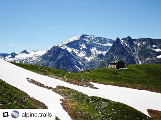
Anyone else dreaming of the mountains today? #mondaymotivation ・・・ 📸 : @alpine.trails Col de Balme - Border between #Switzerland and #France . . . . . #alpinetrails #gooutdoor #adventurenthusiasts #mountainlife #alpinehuts #hikingtrails #hauteroute #hikingaddict #longdistancehiking #lovenature #landscapephotography #trekkinglovers #wildcamping #summerhike #amazingviews #breathtakingviews (at Col de Balme) https://www.instagram.com/p/Bpgtb6_i7G3/?utm_source=ig_tumblr_share&igshid=1xyfh9zfzghkg
#mondaymotivation#switzerland#france#alpinetrails#gooutdoor#adventurenthusiasts#mountainlife#alpinehuts#hikingtrails#hauteroute#hikingaddict#longdistancehiking#lovenature#landscapephotography#trekkinglovers#wildcamping#summerhike#amazingviews#breathtakingviews
1 note
·
View note
Text


New content on this epic hut to hut Alps hike
#wanderlust#hikinginthealps#hikinglife#hiking#walkershauteroute#swissmountains#swissalps#huttohut#alps#hikingineurope#outdoorfitness#trekking#trekkinginthealps
1 note
·
View note
Photo

You know reach the highest point on the trail (📸Grat) and you feel on top of the world? That's how we feel right now having just pushed a big update live to our website. 🎉🎉🎉 Now sharing loads more info on what the Walker's Haute Route is, all the different trail options and how to starting planning your 2019 trip. Link in bio. 🏞✌ Would love to hear what you think - especially anyone blogging 💻 about their 2018 trip now! We're also grateful for all the 2018 Haute Route hikers so far who have shared their 📸 and experiences on the trail - for reposting in the community 👍 #walkershauteroute #hauteroute #swissalps #hikinginthealps (at Haute Route Hiking) https://www.instagram.com/p/BpP4jM2CUIi/?utm_source=ig_tumblr_share&igshid=6qz16ay3bzgr
0 notes
Video
youtube
After celebrating your arrival into Zermatt and completion of the Walker’s Haute Route, make sure to set your alarm for sunrise to witness the Alpinglow of the Matterhorn. It may be the last thing you want to do in the morning but a special moment that will stay with you forever.
#matterhorn#hiking#trekking#alpinglow#sunrise#mountains#wanderlust#hikinglife#zermatt#chamonixtozermatt#huttohut
1 note
·
View note
Photo
#alps #adventure #adventuretime #adventurer #bluebird #glacier #Cheilonglacier #exploremore #exploringnature #hike #keepitwild #keepexploring #lifeofadventures #mountainscenery #mountainscape #nature #naturephotography #neverstopexploring #nationalpark #outdoors #snow #trailrunning #thehikingclub #trailrunner #wanderlust #travelawesome #passionpassport #discoverearth #wonderful_places #worldplaces #exploretocreate #letsgosomewhere #pondering #passion #hiking #thehikingclub #passionpassport #trekking #nature #naturelovers #chamonixtozermatt #outdoor #outdoorworkout #newbeginnings #peace #mountaintherapy #switzerland🇨🇭 #lovehiking #hikingtrail #hikingtrails #swissalps #iloveswitzerland #inlovewithswitzerland #Valais #hikinglife #hikingineurope #hikinginthealps #hikinginswitzerland #walkershauteroute #walker'shauteroute
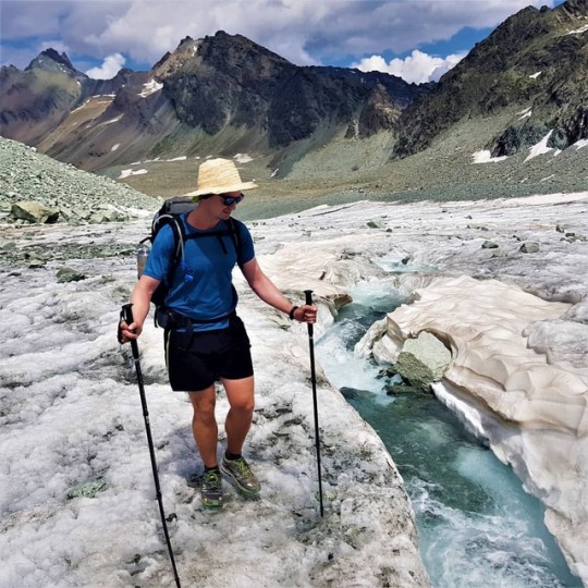
Toto, I’ve got a feeling we’re not in Kansas anymore…glacier crossings are not something I had experience in growing up in Australia. Thankfully, our new hiking buddy Oliver comes through this section of the Haute Route every year. He has previously hiked Norway top to bottom and from Slovenia to France along the Alps so we were in safe hands! #wanderlust #glaciercrossing #hauteroutehiking (at Cheilon Glacier)
https://www.instagram.com/p/BmZBYb8HzUX/?utm_source=ig_tumblr_share&igshid=2fdz8tynt30l
1 note
·
View note
Photo

From Chamonix, France to Zermatt Switzerland, I left behind blood, sweat, and tears. Sometimes it was the breathtaking views of snow capped peaks that brought tears to my eyes because there were no words for the beauty of the Swiss Alps and other times it was physical pain of blisters and sore muscles and the fight against the mentality of knocking another foot off the 49,867 ft of height gain the trail had for us to conquer that had tears flowing down my sunburnt, dusty cheeks. And I loved every second of it. It is a trip that has left me proud and my soul has been filled with memories of laughter, dedication, friends, and chocolate croissants. Report @__ann.marie__ 📷: @davaberrong (at Haute Route: Chamonix, France - Zermatt, Switzerland) https://www.instagram.com/p/BpBm8iiiduJ/?utm_source=ig_tumblr_share&igshid=1j0hpk8akb3dk
0 notes
Text
Haute Route Trail Report
PREPARATION
The Haute Route hike kept coming up as one of the best hikes in Europe, as well as being recognized as the 'classic' Alps hike. I think every hiker is drawn to the Alps for its natural beauty and concentration of incredible trails that range in length and difficulty. Because of the 180km distance, we needed to find a sufficient time period over summer that would fit our work schedule. Luckily, in April 2017, Susan got a new career opportunity that gave us 2 weeks vacation between leaving London and relocating to Amsterdam. This was our window!
We started our detailed research by buying a guidebook and reading the many personal accounts online. The first challenge we faced was working out how we could complete the hike in 9 days, starting mid-June. The guide only presented a 14-day itinerary and we were unable to find an online account of someone that had completed the hike in the 9 days. Without having enough detailed trail information to create an evenly spread hiking plan, we decided to double up 10 of the 14 days in the guidebook.
The second challenge was securing alpine hut accommodation for our itinerary. Most of the huts do not have booking, availability or opening times available online. Some of the websites and contact details weren’t in English, so this added another level of complexity! After many hours of research and back-and-forth in broken French & German, we were able to book 7 of our 9 nights. Given we weren't taking our camping gear and some parts of the trail are very remote, we were concerned that closed huts could prevent us from completing the hike. We decided to visit tourist information offices along the way to determine if the remaining huts were open.
Armed with the best hiking plan possible we packed our bags and headed for the Alps.
There are already many great trail reports from fellow hikers, recounting the details of their trips. Rather than following the same approach for my report, I've decided to focus on the four challenges we faced and what we did at the time to overcome them. I hope this gives you some ideas if you face similar circumstances on the trail and the background to why I've created the various solutions to help future hikers better prepare and hike the Haute Route with confidence.
OUR SELF GUIDED ITINERARY
Our plan to hike the Haute Route by combining stages outlined in the guidebook, lead us to have 3 days of 30km+. Although we’ve regularly hiked this distance in a day, we haven’t done back-to-back days over a longer period. This worried us in the lead up to the hike.
However, as we travelled along the Haute Route, we discovered a lot of open huts and different trail options. If we had more detailed information while planning our hike, we would have been able to build an itinerary that was more evenly spread.
Our original 9-day itinerary was as follows:
Day 1: Chamonix to Refuge Les Grands
Day 2: Refuge Les Grands to Champex (via Fenetre d’Arpette)
Day 3: Champex to Cabane Mont Fort
Day 4: Cabane Mont Fort to Cabane De Prafleuri (via Col Termin)
Day 5: Cabane De Prafleuri to La Sage (via Col De Riedmatten)
Day 6: La Sage to Cabane De Moiry (via Col de Torrent)
Day 7: Cabane De Moiry to Gruben (via Forcletta)
Day 8: Gruben to Grachen
Day 9: Grachen to Zermatt (via Europaweg)
Keep reading below for accommodation details and why we ended up staying in Verbier and Refuge La Barma on our third and fourth night instead of the Cabanes listed above.
The major implication to our trip was that the swing bridge on the Europaweg was not yet being built! We didn’t want to miss hiking the Europaweg as this was one of the sections that hikers raved over. So we decided to still do the Europaweg trail until the Europahut and then head down the valley to continue up to Zermatt. We found some information online before our trip that said this was possible, however, we weren't aware that it would add 4 hours to our day! Hiking up the valley floor into Zermatt wasn’t ideal as it was near the road and train line. Therefore I definitely recommend hikers complete the full Europaweg now that the swingbridge is built.
Despite Europe having a mild 2016/17 winter, we still had snow on nearly all of our mountain passes. It wasn’t enough to change our planned route, however, we did need to use our crampons coming over Fenetre d’Arpette and climbing up to Cabane De Moiry. I recommended hikers take crampons with them whenever they have decided to complete the Haute Route, given it can snow at any time of the year in high alpine areas.
As I hiked along in 2017 (and subsequently 2018), I recorded detailed information on all the subsections of the trail. I’ve now created a tool for hikers to plan their itinerary with more accommodation options and alternate routes to meet their needs. Click here to find out more details on what I've done.
MAPS AND DIRECTIONS
As this hike did not require any wilderness or alpine route finding, we decided to use a guidebook and trail signs, rather than also bringing topographical maps. We felt this was appropriate after reading many times during our research that the Alp trail system is one of the best in the world with fantastic signage. What the online comments fail to mention, is that the Haute Route is not marked on any of the 180km trail. Yes, you heard right, it does not have dedicated markings or signage. There is a maze of trails through the Alps and unlike the Tour Du Mont Blanc, that has its own symbol painted along the trail, the Haute Route picks and chooses from the variety of trails to enable hikers to travel from Chamonix to Zermatt. Hikers will always need to know the next village/peak/point of interest to use the signs effectively.
Wading through the guidebook text usually helped with this, however, sometimes the descriptions weren't enough for us, particularly when trying to find our way out of towns. Small yellow triangle or diamond signs with a picture of a walking person are provided in towns. These confirm you are on a walking trail, but it doesn’t tell you which trail. After navigating the high alpine, we thought this would be the easy part but, embarrassingly, this is where we would often get lost! Thankfully, we had a mobile data package so would use Google maps to navigate our way through the towns. The same cannot be said for all hiker though. I met a couple from the USA who became lost navigating their way out of Sembrancher using only the guide and signs. They added an extra 2 hours and 500m ascent to their day. Needless to say they were tired and frustrated by the time they reached Verbier!
We found that fellow Haute Route hikers brought with them an overload of information to compensate not having one trusted source. Their arsenal included guidebooks (sometimes multiple!), topographic maps, GPS trackers and printed out notes from online blogs/resources. Comparing and contrasting this information was time-consuming and confusing when all you really want to know is whether to go left or right!
The other challenge we faced was planning our water re-fill points, bathroom breaks and food stops. Some of this information was listed in the guide, however, you need to keep wading through the text to find it and then try to estimate how far it is from your location. This brought us unstuck on one of our ~30km double stages from Refuge La Barma to Le Sage. I ran out of water as we climbed up the hot boulder field to Col de Reidmatten. Unfortunately, the glacial streams noted in the guide were filled with rock flour from the erosion so I chose not to refill. The next spot for water was on the way down to Arolla, but the damage had already been done. I was hit by a combination of heat stroke and dehydration which lead to a very uncomfortable afternoon and evening. It was my own fault for not being more prepared for that section, however, it made me think that there must be a better way to help hikers see the location of important points on the trail like water refill locations.
With advances in mobile phones and mapping technology, there is a better way to present the key information and directions for the Haute Route. Click here to learn about the offline mobile maps we've created to help future hikers.
SHORTCUTS
I had never taken a shortcut when hiking before, however, I hadn't completed a hike as long as the Haute Route either. With 3 days of ~30kms in distance, we weren't sure how we'd cope. As our bodies began to tire over the first few days, we decided to look for opportunities to either shorten or shortcut our days. This was difficult to do on the trail as we didn't always have an internet connection or could confidently translate remote timetables into English.
Our first shortcut opportunity was a blessing after finding out that Cabane Du Mont Fort was closed. This meant we had to stay in Verbier instead, which added appropriately 8km and a 700m climb to the following day. We discovered that a gondola was running from Verbier to Les Ruinettes which would cut out most of this additional distance and elevation gain. However, it did come with the catch of only running for 15min at 10.30am. Considering we were aiming to make it to Refuge La Barma for that night, this was a late start but we thought the legs would appreciate it in the end.
On another one of our 30km days, we weren't as successful with our shortcut. We wanted to catch a bus from parking Du Glacier (near Cabane De Moiry) to Zinal in order to reduce the day to 5-6 hours instead of 10-12 hours. Our translation of the bus timetable wasn't good enough as we discovered that it actually hadn't started running for the summer season. The best we could do was a hitchhike along Lac De Moiry to cut off about 4kms from a lovely German filmmaker who was taking some drone footage of the glacier. This short hitchhike helped us make it to Gruben, just in time for dinner.
Having an uneven hiking itinerary caused us to look for shortcuts, however, others we met used them to rest their tired legs, avoid wet weather or simply give themselves more time on remote parts of the trail when hiking up or down ski-hills. Fellow hikers wished they had information on shortcuts ahead of time rather than stumbling upon opportunities or desperately searching for them when in need. Click here if you want to see what we'have done to make this information available.
ACCOMMODATION
Due to hiking in mid-June, securing accommodation was difficult in some spots. As I mentioned above, most of the alpine huts do not have ways for hikers to check availability and book online. This meant it took a lot of time and effort to secure each nights accommodation via email or phone, sometimes only in French/German. The tricky bit is the juggling act to check the availability of all your selected alpine huts, adjust hiking dates due to some being closed or fully booked on your target night, recheck availability of others with new dates...and repeating until you've booked a series of dates that line up with your hiking plan.
We secured most of our nights ahead of time, however, did not receive a reply from Cabane Du Mont Fort and Cabane De Prafleuri. The tourist information office in Verbier told us that Cabane Du Mont Fort wasn't open yet, although they didn't know about Cabane De Prafleuri. We adjusted our plan to stay in Verbier and take a shortcut the next day, however, we headed for Cabane De Prafleuri without knowing if we could stay there. Our backup options were to come down to Grande Dixence where there was a hotel or continue on to Cabane des Ecoulaies or Refuge la Barma. Chatting with others coming towards us on the trail, we were told the Refuge La Barma was open so decided to head there. In the end, it turned out that both Cabane Du Mont Fort and Cabane De Prafleuri also had winter rooms open where fellow hikers had stayed in, so we could have stuck with our original plan.
The lack of consolidated information online made the booking process harder than it needed to be, as well as caused us to carry risk in our itinerary that we wouldn't be able to stick to our overall plan. It's not easy for some for refuges to bring their availability and booking systems online but click here to find out what we're doing to help future hikers with this process.
FINAL THOUGHTS
The Haute Route is the best multi-day hike I have done and lives up to its reputation as one of the top in Europe. Check out more photos from our trip in the gallery.
You can certainly complete it with the current resources available and information you cobble together online. Our trip in 2017 and the many other personal blogs you've read are testaments to that!
But just because it is possible, does not mean that you need to settle for carrying the same uncertainty we did into your trip. I have the best hiking experiences when I'm confident in my daily itinerary and trail information in my hand. Not when I am worried about getting lost, whether my plan is achievable and not knowing if I'll have a place to sleep at night! I've tried to do something about it and am keen to share it with others so they can hike the Haute Route with confidence.
I'm giving everything away for free until the end of October 2018 in return for feedback, improvement suggestions and words of encouragement, so I know the effort has been worthwhile!
Happy Hiking
Brendan
#hiking#chamonix#zermatt#montblanc#matterhorn#walkershauteroute#hauteroute#backpacking#multidayhike#thruhike#hikinglife#europaweg#switzerland#swissalps#swissmountains
0 notes
Photo
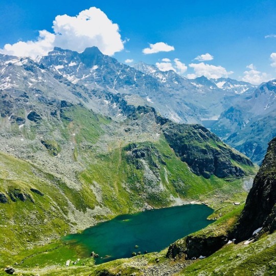
Turning the corner at Col Termin and seeing Lac De Louvie for the first time is pretty breathtaking. Situated at 2,214m above sea level, this glacial lake is a spectacular colour. If you have time, definitely take a little de tour down to the lake. There is a great hut, Cabane de Louvre, which serves meals, hot showers and a warm bed! A great place to rest those weary legs. #swissalps #verbier #hauteroutehiking (at Lac de Louvie) https://www.instagram.com/p/Bn-mD00CgQP/?utm_source=ig_tumblr_share&igshid=w23xfwt5s385
0 notes
Photo
Toto, I've got a feeling we're not in Kansas anymore...glacier crossings are not something I had experience in growing up in Australia. Thankfully, our new hiking buddy Oliver comes through this section of the Haute Route every year. He has previously hiked Norway top to bottom and from Slovenia to France along the Alps so we were in safe hands! #wanderlust #glaciercrossing #hauteroutehiking (at Cheilon Glacier) https://www.instagram.com/p/BmZBYb8HzUX/?utm_source=ig_tumblr_share&igshid=2fdz8tynt30l
1 note
·
View note
Photo
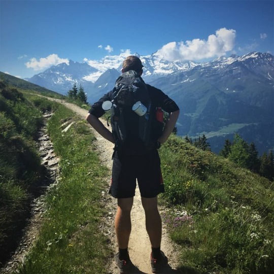
I’ve done a lot of things in my life because it would ultimately help me make more money. Hiking is not one of them. I go hiking because it grounds me to our planet, inspires my life, provides natural therapy to resolve troubles on my mind, all while giving me a workout that keeps my body in tip top condition. I go hiking for love, not money. #wanderlust #swissalps #hauteroutehiking (at Verbier, Switzerland) https://www.instagram.com/p/BmY_pyoHzkh/?utm_source=ig_tumblr_share&igshid=tvkb67nfo7od
0 notes