Statistics
We looked inside some of the posts by imprail and here's what we found interesting.
Average Info
Notes Per Post
941
Likes Per Post
694
Reblog Per Post
236
Reply Per Post
11
Time Between Posts
12 days
Number of Posts By Type
Photo
16
Text
1
Last Seen Tumblr Blogs


Fun Fact
28.6 is the average number of monthly visits per US mobile user.
Photo
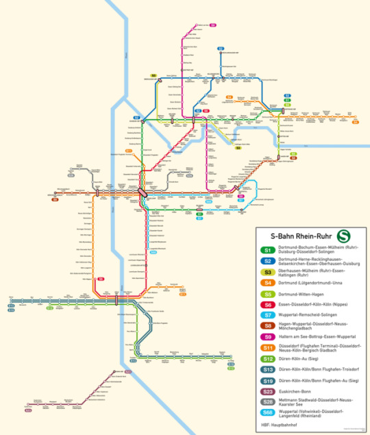
S-Bahn Rhein-Ruhr (Rhine-Ruhr S-Bahn) of North Rhine Westphalia, Germany.
This took quite the time to do.
High-Res download link can be found on my DA:
http://imperial-ascendance.deviantart.com/art/Rhine-Ruhr-S-Bahn-688568325
#imprail#rhine ruhr#rhein ruhr#dusseldorf#cologne#koln#duisburg#bonn#dortmund#gelsenkirchen#oberhausen#essen#bochum#wuppertal#germany#transit maps
99 notes
·
View notes
Photo
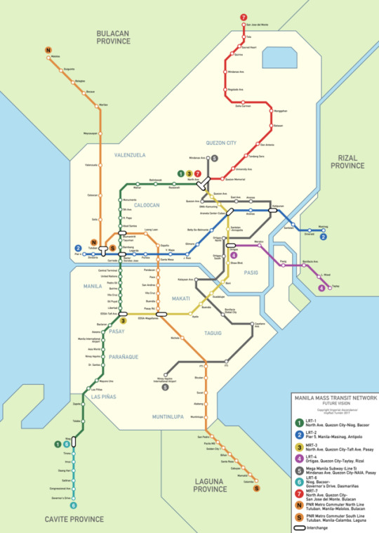
You really thought I was gone?
Well, I’m back, and here’s a map of my home city’s potential future rapid transit network. Portions of Lines 1, 2, 3, and the Commuter Line (PNR) already exist, while extensions to Lines 1 and 2 as well as a new Line, Line 7, are under construction.
Enjoy.
96 notes
·
View notes
Text
Hiatus
This blog is currently under hiatus, for the time being. I lack the drive to do more maps, and a good chunk of them were based off satellite imagery sourced elsewhere, (which explains why the later ones are more geometric), so because I don’t feel like doing it for the moment, you can check out my other blog, Intellectually-Absent.
3 notes
·
View notes
Photo
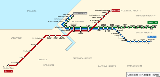
Cleveland RTA Map. My design.
50 notes
·
View notes
Photo
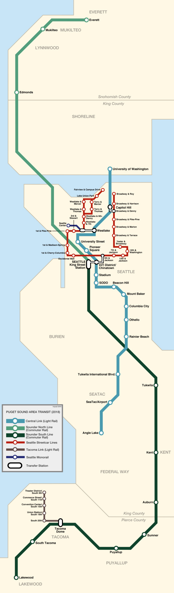
I fixed the Seattle map.
Edits include changing “Pullayup” to “Puyallup” and giving the streetcar its extensions.
144 notes
·
View notes
Photo
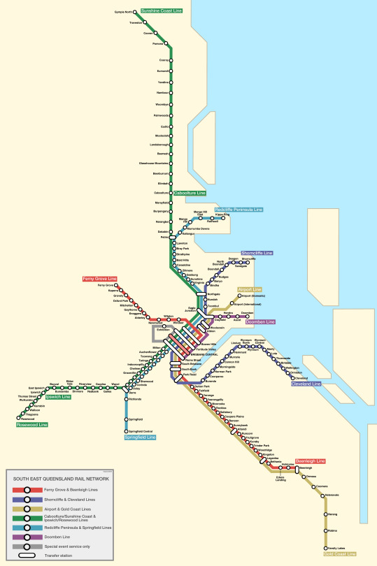
Final version of the Brisbane map.
Also, I might redo the Seattle map as only now I realize it is riddled with errors.
8 notes
·
View notes
Photo
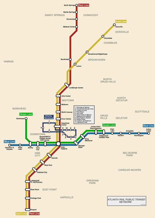
Atlanta Rail Map (includes the unusually small streetcar loop)
128 notes
·
View notes
Photo
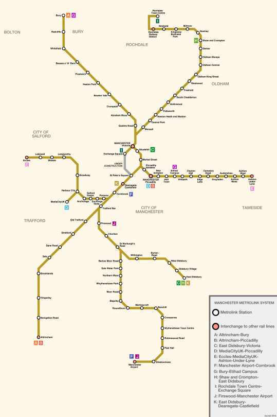
Manchester Metrolink System (my design)
5 notes
·
View notes
Photo
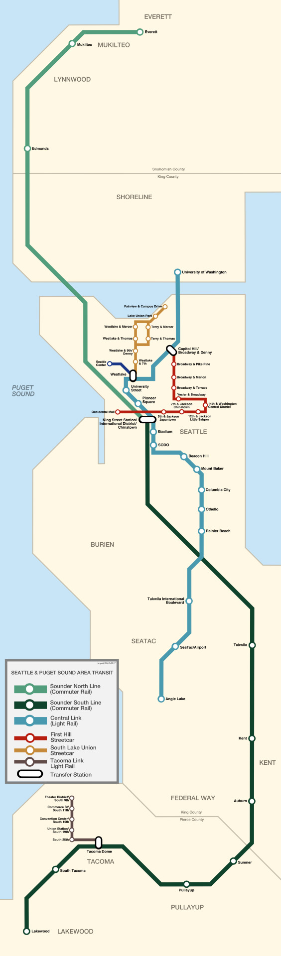
Seattle/Puget Sound area rail map.
It’s just one big line.
157 notes
·
View notes
Photo
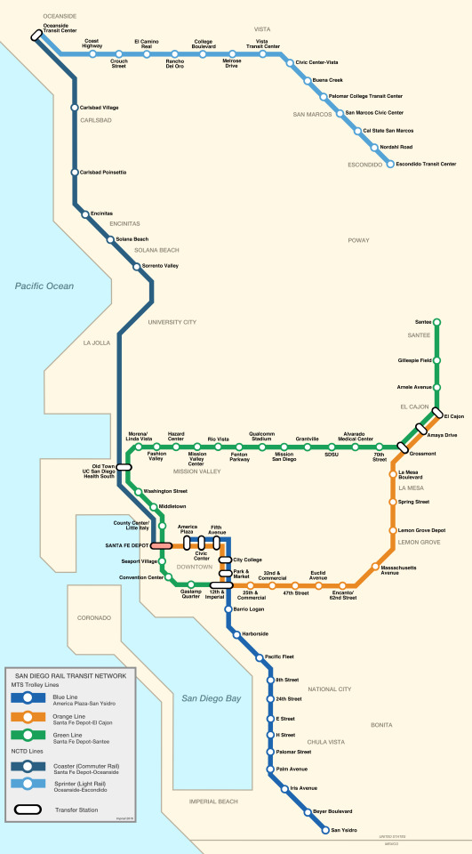
San Diego combined rail map.
Based off an older map I did.
101 notes
·
View notes
Photo
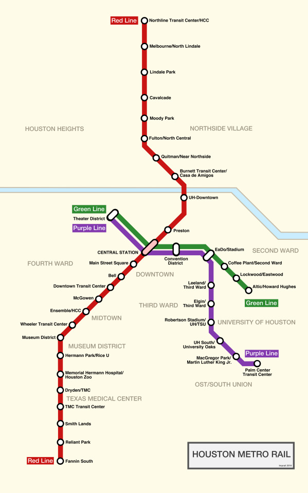
Houston Metro Rail Map.
For a city of 6,000,000 people, this seems unusually small.
Even compared to Dallas.
94 notes
·
View notes
Photo
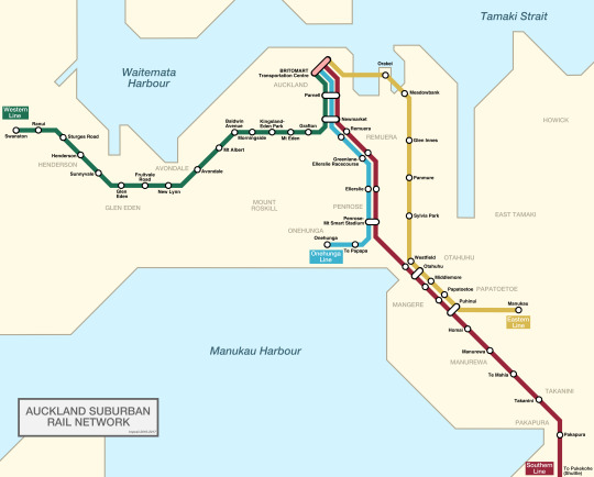
Auckland Suburban Rail.
My design.
3 notes
·
View notes
Photo
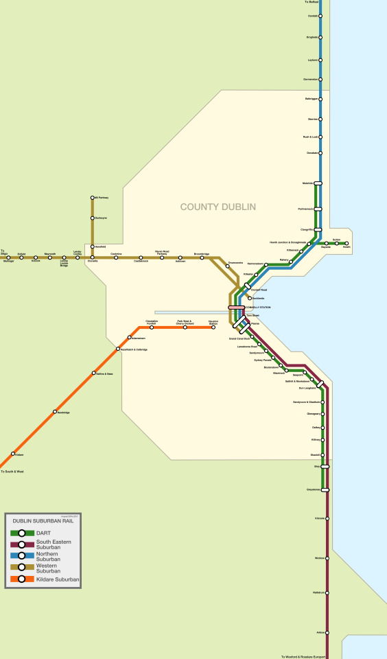
Dublin suburban rail map.
Beyond DART, it seems sparse.
Then again, Ireland has the same amount of people, or less than, Long Island.
7 notes
·
View notes
Photo
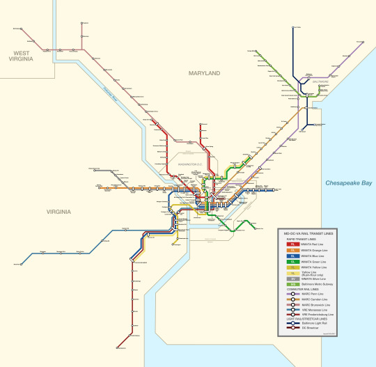
Maryland-DC-Virginia area transit map.
An improvement based on other maps, but shoehorned into my own design.
Also, I realized that some of my older maps are erroneous.
Hopefully, these new ones help.
--IA
21 notes
·
View notes
Photo
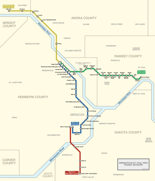
Minneapolis-St. Paul Train/BRT Map.
Based off the actual map.
13 notes
·
View notes
Photo
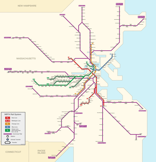
MBTA Rail System.
Based off the actual map but tweaked a bit.
6 notes
·
View notes
Photo
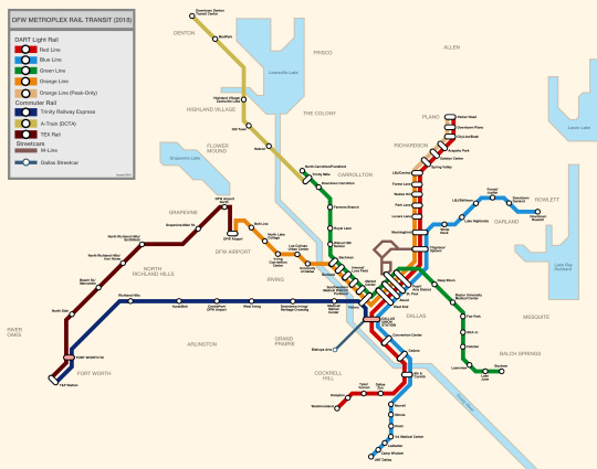
DFW Metroplex Rail Transit System (2018).
My design.
6 notes
·
View notes