Statistics
We looked inside some of the posts by minutemaps and here's what we found interesting.
Average Info
Notes Per Post
1
Likes Per Post
1
Reblog Per Post
0
Reply Per Post
0
Time Between Posts
1 day
Number of Posts By Type
Photo
4
Last Seen Tumblr Blogs


Fun Fact
Tumblr is available in 18 languages.
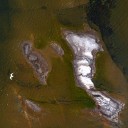
Photo

I became interested in flying drones in part to have access to better aerial imagery for GIS purposes. I created this from 69 aerial images flown ~80 metres taken last August, stitched them together in Pix4D, and the output’s been wonderful. While I could certainly repeat with an actual flight plan (I eyeballed my route) and way more imagery, I’ve been impressed with the process: along with this and from Pix4D, I derived a DSM, 3D textured mesh and point cloud. Looking forward to figuring out what else I can do with this technology.
I have a lot to learn about drones, drone photography, and image processing and am thoroughly looking forward to the process.
0 notes
Photo

#2 map, again Wonderdraft, another set of default settings and a new theme. I could see how you could spend some time on these. Tomorrow something different.
0 notes
Photo

First map a fantasy map? What can I say, have always wanted to try one. If I haven’t explicitly detailed elsewhere, I’m not going for a perfect map but making quick impressions for fun. And this was very fun, Wonderdraft, plus does 95% of the work for you. Time: 30-60 mins.
0 notes
Photo

Obviously not a map but a fave image taken with my UAV this summer, for context of the avatar. Here’s to a personal experiment- is it possible to make fast maps frequently, not too much worrying about form and tradition- but to quickly explore what can be made and how, and to investigate whether or not fast and frequent production of maps leads to improvement over time. Here’s to this!
1 note
·
View note