
Dartoor Walks The ramblings of a rambler Welcome to my Walking Tumblr. It is a place to share my love for walking. Mostly it will include route descriptions, which I hope you will try, if you ever find yourself near the place. In any case I hope it inspires you to get out into the wilds.
Don't wanna be here? Send us removal request.
Statistics
We looked inside some of the posts by paul-s-walks-uk-blog and here's what we found interesting.
Average Info
Notes Per Post
5
Likes Per Post
5
Reblog Per Post
0
Reply Per Post
0
Time Between Posts
1 day
Number of Posts By Type
Text
4
Photo
13
Last Seen Tumblr Blogs


Fun Fact
When “GIF” was named word of the year in 2012, Oxford Dictionaries U.S.A. credited Tumblr for pushing the word.
Text
Walk 8 : Dartmouth to Totnes
‘A good local pub has much in common with a church, except that a pub is warmer, and there's more conversation.’
William Blake
One of the area's truly great walks, this daylong ramble follows the wooded banks of the broad and beautiful river Dart, on a route crammed with gems and jewels of human and natural history.
The South Devon AONB website synopsis of the walk
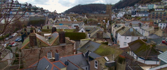
View over Dartmouth
Walk data
Distance: 12 Miles, 19.3 km
Grade: Moderate. Easy walking, but on average uphill
Start Point : Bus stop at North Embankment, Dartmouth (sx878512)
End Point : Steam Packet Inn, Totnes (sx805600)
Facilities: Full range of facilities at Dartmouth: Shops, supermarkets, pubs, toilets, banks. Also at Totnes. On route the are several pubs, all of which serve food. There is a village shop and cafe in Dittisham.
Transport: There are buses between Dartmouth and Totnes, regular on weekdays, but only twice on Sundays. There is also a river ferry between them, it is a beautiful trip, but but it’s timing is dependant on tides, so the timetable must be checked before hand ( It is operated by the Dartmouth Steam Railway and Riverboat Company-check here for times). Totnes is easily accessible by bus or train from either Plymouth or Exeter. Dartmouth is directly accessible by bus from Exeter and Plymouth, but the busses also service the local villages on the way, so the journey time is in either case in excess of two hours (but you do get to see lots of scenery). Bus and train journeys can be planned here.
Maps : Ordnance Survey Explorer OL20. Coordinates are from this map. A compass is not needed, but the map is strongly advised, even though the trail is well signed.
An album of Photos from this walk can be found on my Facebook Page
Walk overview
This is a fairly long but straightforward walk following a recognized and clearly signposted trail (The Dart Valley Trail) between two of Devon’s most historic and lively towns. It starts in Dartmouth, near where the river flows into the sea, and ends in Totnes which is the farthest point navigable by large boats.It consists mostly roads and country footpaths. It is not a challenging walk, although a couple of small stretches are perennially muddy, so you will need good waterproof boots or shoes. There are a few long, steepish parts, and since the trail is following a river inland, the path is generally uphill.
This is a great walk if you want to experience some good Devon pubs. Don’t try too many, or you may never get to the end!
Route Maps and elevation
Stage 1 : Route map and elevation
Stage 2: Route map and elevation
Stage 3 : Route map and elevation
Dartmouth
Dartmouth is on the western bank of the mouth of the Dart. It is a busy place, with seagulls crying and flapping around all day, and many boats bobbing up and down on the water.
Although Dartmouth has a natural deep-water harbour it was only an agricultural settlement at the time of the Norman Conquest (1066), but it soon began to grow and by the fourteenth Century it was well known enough for Chaucer to include one of its inhabitants among his pilgrims ‘A schipman was ther, wonyng fer by weste;For ought I wost, he was of Dertemouthe.’, who tells a somewhat morally dubious story about money lending.
By the Elizabethan times it was a thriving port. Castles were built on either side of the estuary with a chain between then, that could be pulled up to prevent invasion from the Spanish fleets. The castle on the Dartmouth side is worth a visit. The Pilgrim fathers stopped at Dartmouth on the way to America (they hadn’t got very far at that stage).
The Navy has since had a keen interest in Dartmouth and the naval officer academy still sits in in an imposing Victorian building that dominates the a large hill on the edge of the town
The first bridge across the Dart is at Totnes, over 10 miles upstream. but in Dartmouth there are two vehicle ferries and one foot passenger ferry across to Kingswear on the eastern side.
There is plenty to explore. To find out what to see and do, and for any events happening, click here.
Dartmouth is one of those English towns which has grown up in a sort of hotchpotch fashion, so that it has many house from different periods. On the steep hills such as this the house frequently have a front door on the street, once inside you go down to the rest of the house instead of up. Some have little bridge connecting the front-door to the street. It is common in Devon towns for house to be painted in different colour. Dartmouth is no exception: There are blue houses, pink house, yellow house. Some have slate fronts, some wooden, some granite or limestone.
If you want to sample a traditional devon pub, there are too many to lst here, but check out this page. Almost all will serve good food (frequently fish and seafood, freshly caught) as well as a range of local ales.
On the subject of pubs-Devon has a host of local breweries, some large, some tiny. Apart from making very good beer, they also seem to be in competition to come up with weird names for their beverages. Here is a list of some them along with the breweries that make them. They are not all available everywhere, although Jail (personal favourite) and Otter are most common
Jail Ale (Dartmoor brewery, Princetown)
Pandit (New Lion Brewery, Totnes)
Cor bugga! ( Teignworthy Brewery, Newton Abbot)
Devon Dumpling (Bays Brewery, Paignton)
Otter Ale (Otter Brewery, near Honiton)
Pheasant Plucker (Hunters Brewery, Ipplepen)
Black Ops (Taw Valley Brewery, North Tawton)
Pandemonium (South Hams Brewery, Kingsbridge)
Repeat Offender (Stannary Brewery, Tavistock)
Tuckermarsh Pale (Bere Brewery, Bere Alston)
If you are from outside the UK you can relax and forget the myth of warm beer.The British have not drunk warm beer since the 1970's (except of course when they do... at beer festivals, where it is more or less compulsory)
Stage 1 : Dartmouth to Dittisham (4.5 Miles, 7.2 km)
The walk starts at the south west corner of the little square harbour near the waterfront. You will see a kiosk that sells boat-trip tickets, and on the lampost next to it a blue sign, which shows in white two castles with some wavy lines below. This is the first sign for the trail. You will see it frequently. Often it will be accompanied by a white arrow on a blue background showing the direction to walk. The trail is part of a much longer trail The John Musgrave Heritage Trail (this is 32 miles long) so the signs for this can also be followed (yellow and brown circles, with an image of aboot print inside).
Follow the road past the little harbour and past the white and blue painted Royal Castle Hotel until you come to a car park on you right. At one corner you will see a small street called Zion Place walk along this to the end, turn right and almost immediately there is a long flight of stone steps called Coxs Steps. Climb these til you come to a narrow road called Clarence Hill.
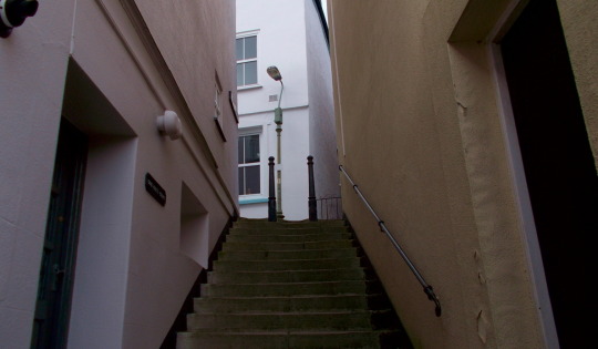
Cox’s Steps
Turn left onto Clarence Hill and follow it along. It eventually becomes Townstal Hill and the Church Hill. Towards the end in bears right and comes to the main road out of Dartmouth (The A379, College way at sx870515)
The trail goes the the end of Old Mill Lane, Down a flight of steps and into Old Mill Lane This is a pleasant walk on a country road that descend gradually to Old Mill Bridge (sx861519), situated, unsurprisingly on Old Mill Creek. Old Mill Creek always seems to be at low tide. It is pleasant to sit on the wall at the end of the bridge across it and watch the water fowl hopping around in the mud. The Old Mill sir on one side of the bridge. One can only imagine that the stream to the bridge was once more lively, as it’s current sedately flow would not be enough to drive a mill wheel.
‘Old Mill’ is a self-explanatory place name. But not all the names on the map are. Here is a list of some names that are not. They are all on or close by this trail. I can guess at the origins of some of them, about others I can only wonder..
Tippity Van
Dinah’s Side
Blackness Point
Bozomzeal
Sprat Lane End
Poor Bridge
Corkscrew Hill
Higher (and Lower) Yetson
Hothole ( I kid you not)
Lower (and Higher) Gribble Plantation
From Old Mill Bridge turn right and follow the road. It soon becomes a country footpath, called Lapthorne Lane, which quickly brings you to the edge of Hole Copse. Here you have two choices. Both are signed to dittisham. You can either follow straight ahead along the lane or right into the woods. The fist is 2 miles to Dittisham, the second is 2 3/4. The longer way is more pleasant and takes you through Hole Copse and Great Copse. It will also give you some nice views of the Dart, where you can see to the edge of Dartmouth, with the Higher Ferry, laden with cars going back and forth.
Either way will bring you to the road just past Bozomzeal (sx861539). This is Fire Beacon Hill. This is so named as it is the site of one of the beacons that were lit to warn of the SPanish Armada. You can see the beacon across the fields, a tall pole with an iron basket on top. It has a grim look, like a gibbet. The fire beacons were lined along the whole South West. More information on these can be found here.
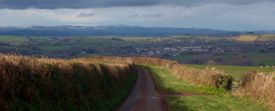
Dartmoor in the distance, from Fire Beacon Hill
Take the footpath that appears on the right, down through fields of grass and sheep. This eventually joins a farmers road. Here you will be glad if you have good waterproof boots. The farmer here must use a lot of heavy machinery, since the road is always deep in mud and churned up by giant tyres. You can walk on the banks of the road with some care. It is not a long stretch, and after a couple of turns you find yourself in Dittisham (sx861550)
Dittisham
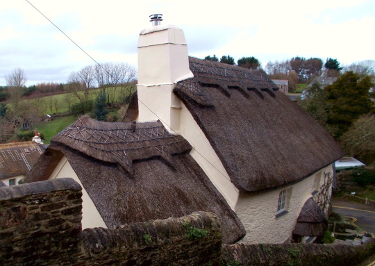
Thatched cottage in Dittisham
If you talk to any of the residents and don’t want to look like a Grockle, Dittisham should be pronounced Ditsum, or even better Dits’m. (This is a mild reduction of a place name for Devon- There is a village named ‘Woolfhardisworthy’ on maps, but which the locals pronounce ‘Woolsery’)
The trail only skirts the top of the village, which is a shame, as this is one of the best places to visit on the river. It is quite ancient, having been founded in about 660 ad by Saxons, who had found the Dart to be a good trading route inland.So take a detour into town if you have time.It has steep lanes to the water, clustered with old cottages. There are two good pubs, a shop and a good coffee house. A guide to the village can be found here.
stage 2 : dittisham to asphsprington (4.6 Miles, 7.4 km)
The trail passes along the top of Dittisham, following the road until it passes the hamlet of East Cornworthy, after which is cuts through a wooded area on a track to the right. This little country path must once have been a more important way, as there is a small but substantial bridge over the ltlle river. It is odd to find it in this quiet lane, on a dirt track. It has the curious name of ‘Poor Bridge’
Cottage near East Cornworthy
Woods and small river near Poor Bridge
The track becomea a road and leads through the village of Cornworthy, another small ancient setlement. Agin it has a nice pub, the Hunter’s Lodge. At the far side of the village standing in a field is the remains of a priory, where Nuns lived from about 1200 to the mid 1550′s. It is marked Gatehouse on the map. (sx821555)
From cornworthy the trail turns right off the road and paases downhil towars Bow Creek, another tribuatry of the Dart. It passes through the small Charleycombe Woods, which are full of oak and ash trees.The path turns left. On the right is bow creek, where if you are lucky you can see herons flying low o ver the mud-flats. To your left is Corkscrew Hill. A lot of water flows off the hill after rains and the trail here is often VERY muddy. But there has been a lot of tree planting done recently, so as sapling grow into a new wood, it should they should contain the wet: At the monent though, take care not to get wet feet.
The trail rejoinns the road from Tuckenhay to Bow Bridge. Ther is a good pub in each of these places, The Maltsters and the Watermans Arms. Both have seating with river views.: In summer both are likely to be busy.
Cross Bow Bridge and head up hill to Ashprington.

The Waterman’s Arms, Bow
Ashprington
Ashprington has been in existence since at least the time of the Norman conquest, and is mentioned in the Domesday Book, in 1086, (where it is called Aisbertone). It had about 22 people living there. It has a church which dates back to this time, although the only remaining Norman part is the font. The current church dates from the fifteenth century. There isn’t much happening in Ashprington. It is a quiet, peaceful and secluded place. It has a pub, though, the Durant Arms. There is a bench by the churchyard, so if you need a nice long sit down, having walked just over 9 miles, with still another 3 to go, this is a good place to watch the world slowly moving by.
Stage 3 : Ashprington to Totnes (2.9 Miles, 4.7 km)

Asphrington Church Graveyard at sundown
This is the easiest part of the route as it is almost entirely in the Sharpham Estate until it reaches Totnes. The estate keeps the path well signed, neatly gravelled and clear.
From the bench by the church head towards Sharpham (i.e. uphill) following the road until you get to the estate gate. Here you leave the road and take the footpath to the left.
Sharpham Estate
Sharpham Estate dates from around 1260, but it’s current form dates from the 18th century, when Captain Philemon Pownoll, who was something of an adventurer, made his fortune capturing a Spanish treasure galleon. (He had an adventurers death, too. He was hit by a cannonball in a fight with the French in the North Sea.) If Philemon Pownoll seems a crazy name, consider that his grandson was named John Bastard.
Today the estate is managed by the Sharpham Trust. The mansion house is now a center for events and courses. Being close to Totnes ( see below) these are often New Age type events. The Trust supports many conservation schemes. It also has a vineyard, producing a range of wines, and makes it’s own cheeses. If you have time it is worth diverging from the trail and visiting the restaurant/cafe by the river front, and trying the wine and cheese. If it is summer, you may even have time for a guided tour of the vineyard.
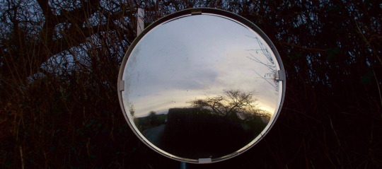
Evening in a mirror in a hedge
On arriving it rhe end of the Sharpham footpath, turn right on the road and at the bottom of the little hill you will find the Steam Packet Inn, by the river. Reward yourself with a nice pint and rest your feet, before going into town.
Totnes
Totnes is chefly famous as being a center for alternative lifestyles. It calls itself a transistion town, and ven has it’s own (not freuently used) currency. There are crystal shops, and mindfulness courses, and always buskers. But there is more to the town. It has a Norman Castlt, a museum, a medieval guildhall and the narrow streets at the tiop of town, still on the medieval layout. (With good Devon Common-snse, these are called ‘The Narrows’). There are lots of coffee shops, cafes and resturants: To many to list, but see here

Totnes High Street
https://www.pubsgalore.co.uk/areas/totnes-town/devon/
3 notes
·
View notes


Text
Recipe 1: Steak et champignons, à l'ail sauvage et aux orties

Nettles ready to boil
Names for meals always sound more sophisticated in French. Thus ‘puree de pommes de terre et blancs à la sauce tomate’, is something you might pay a small fortune for in a Michelin restaurant , whereas ‘mashed potatoes and baked beans’ means it’s the end of the week and you haven’t done any shopping
This camping recipe is Steak with Wild Garlic and Nettles.
This is my favourite camping meal in springtime It can be cooked using just small frying pan and a camping pot. In true wilderness style, you can omit a plate and eat it from the frying pan, the implied repudiation of bourgeois habits helping you feel that you really are closer to nature, whilst also saving on the washing up. In addition, two of the ingredients are entirely free! And it can ready to eat in about 15 minutes. What more could a tired walker ask for?
Ingredients
A nice steak, any variety that will fry quickly
a little cooking oil
some button mushrooms
a small bag of nettle tops
small bar of wild garlic leaves.
salt and pepper to taste
(optional) a dash of hot pepper sauce
water
You will need also
A penknife
a spork
a camping pot and a camping frying pan
A camping stove and fuel, if you can’t have a fire
a couple of small plastic bags
matches or lighter
gloves
Note on safety: I often make meals or boil water in my tent ‘porch’, but I would not do this if frying. Even if you don’t set your tent alight, it will smell of fried food for ages.
For this recipe you will need to take the steak, the mushrooms, the oil and the condiments with you:
The steak will need to be kept fresh. I have a little cool bag I keep it in. If you are camping more than one night, you will need to eat the steak on the first night. You only need a very little oil. I keep mine in one of the small plastic bottles that are used for liquids on flights. The condiments: I use the ones supplied in restaurants, in the tear open sachets. These will need to be kept wrapped separately in your gear. Pepper and salt leakages are OK, but I doubt anyone would want their camping gear smeared with hot pepper sauce.

A perfect place to forage wild garlic
Finding the garlic and nettles
It is always good advice to avoid picking any plant you are going to eat unless you are sure of its identity, but both of he plants here are easily recognisable.
Wild garlic and young nettles are spring plants.
In lowland places nettles start to grow in March and wild garlic is most abundant in April, but because the moors are on high ground spring tends to be fairly short and late, and in April you will still find plenty of young nettle tops.
The wild garlic loves shady wooded places. You will not find it on the more open moorland. Fortunately the edge of the moors has ample woodland, and in spring the paths are bordered with acres of the attractive white garlic flowers. It is easy to identify, by its little clumps of white petals, six to a flower. Simply pick the amount the green leaves that you need and seal them is a bag. Avoid damaging the plants by taking only a leaf or two from each one, and collecting them from a wide area. Where they are abundant this is easy. Crush a leaf in your palm and smell, and you will be rewarded with a subtle garlic scent. Wild garlic frequently grows around the sites of iron age forts or other remains, so much so that it is considered an indicator sites of ancient settlements. No doubt our ancestors found it useful in the kitchen, so maybe they would have appreciated this recipe.
Nettles also are abundant in the woods and the roadsides, but they can also be found on the high moor in sheltered, relatively dry places. Like wild garlic, nettles also grow where people have lived, so they can frequently be found in old tinners huts and in shelters worked into the ancient barrows. Certainly they would have been eaten. They also grow best in soil containing phosphate, and human refuse would once have consisted of mainly of ash and bones, both of which are phosphate-rich. Unless you have hands of leather, or are naturally masochistic, you will need to wear your gloves to pick them. Choose the youngest freshest leaves at the top of the plant. Nettles, like spinach tends to cook down a lot, so make sure you have plenty. Seal in a bag, and you are ready.
Getting ready to cook
The pictures here are from two separate camps. You will notice that one has a fire as a source of heat, and the other a gas stove. If you are cooking on a fire, remember to get is hot enough, make sure that it is contained, and that there is somewhere to put the pots which is stable.
If you have bottled water, fine. If you are using water from a stream or river, remember to boil it thoroughly prior to cooking.
Method
Chop the mushrooms and garlic leaves. Keep seperate.
In the pot, cook the nettles. They need to be blanched for only a couple of minutes in a little water. This also completely destroys the chemical that makes them sting, so don’t worry about hurting your mouth. Set aside in their pot.
Now fry the steak in a little oil. How long depends on how you like your steak, but please be careful that it has thoroughly heated through. A little before it is cooked add the mushrooms and continue frying until they are golden brown in colour

Frying the steak on a gas stove. Make sure the stove base is stable before cooking.

The cooked steak and mushrooms.
Set the steak aside and put the (drained ) nettles and chopped garlic leaves on the frying pan and cook for a minute. Now add the steak back and cook for few minutes to allow it to absorb some of the liquid.

Steak with leaves
Add the mushrooms, salt, pepper and a dash of pepper sauce. Cook for a further minute and it is ready.
Serve accompanied by a cup of steaming campsite coffee. Wash up, get in your sleeping bag and listen to the foxes barking as the sun goes down. If they don’t have this in heaven, I ain’t going.

Don’t forget the coffee!
0 notes
Text
Tents 1 : Me and my Laser
‘It always rains on tents. Rainstorms will travel thousands of miles, against prevailing winds for the opportunity to rain on a tent.’
Dave Barry

Sleeping for a night in a tent is not everyone’s cup of tea. My wife for instance. To get her to spend a night under canvas, except (maybe) under very swanky glamping conditions, would require me to drug her, carry her unconscious to a campsite and then drug her again so she didn’t wake up til the morning..
For those who like it, especially those who like wild camping, there is no other activity to compare. Initially it is an eerie experience to sleep alone in the darkness, miles possibly from the nearest other human, with a cold stars above and the cold ground below. But once accustomed to it, nothing seems more natural. In fact, unless you are going to jettison a tent entirely and shelter in a cave or under leaves at the foot of a tree, nothing is more natural. It is not really natural for a human to sleep in a bed, in a stone structure, with electric light and controllable heating. The only advantages to sleeping in a building are (1) It makes it so much harder to get hypothermia and (2) It makes it almost impossible to be eaten by bears. I have a very snug sleeping bag, and there have been no bears on Dartmoor for a couple of thousands years, so I am not generally at much of a disadvantage compared to a house dweller, although I readily concede that in a small tent it is impossible to get up in the middle of the night and make a cheese sandwich, which is the chief blessing of civilisation.

Camping at Pile’s Copse on Dartmoor. The weather was dry enough to make a fire!
This is a post about my favorite tent. This sounds a little sad. Maybe it is a little sad. But everyone who trail walks will have a favorite tent, and argue it’s virtues with any other backpackers with all the passion of a crank. I have seen someone unpack at the end of a long day’s walk, a tent which was the size of a small house. Honestly. It had space for a sofa and a TV, and could not have weighed less than 4 kilograms. I wondered how on earth they could even manage carry that enormous beast on their back for miles upon miles. On the other hand, I have also seen someone, in the pouring rain, set up a shelter which looked for all the world like a few meters of tissue paper with a bendy pole glued to it. Why? because they were their favorite tents.

My Laser in sheltered conditions.
My favorite tent, the one I take in hiking preference, especially if going on a long trip, is called a Terra Nova Laser Competition 1. I freely admit that I have no idea what sort of competition it is designed for, nor why the makers sought to connect it with a device for producing a beam of coherent light. I guess the marketing people thought it sounded sexier than ‘Medium priced, lightweight hiking tent in a fetching olive colour’.

My laser in not so sheltered conditions
For those who like such stuff, here are the tent’s technical details, taken from the Terra Nova website
Sleeps: 1,2
Season Rating Spec: 3 season backpacking
Free standing?: No (tent requires guy lines to be pitched)
Minimum Weight: 0.86Kg (1lb 14oz)
Packed Weight: 0.97Kg (2lb 2oz)
Pitch Time (estimate): 5 mins
Number of Porches: 1
Number of Doors: 1
Pitch Type: Fly and Inner pitch together
Packed Size: 42x12cm
Flysheet: Watershed Si2 R/S 5000mm
Floor: Waterbloc R/S 6000mm
Poles: 8.7mm DAC NFL
Pegs: 10 x 11g Alloy
Guylines: 4 x Dyneema Reflective
Inner Door: Half Mesh
I must say something about the claim, ‘Sleeps: 1,2′. It doesn’t. It sleeps 1. You could only share it with another person if you were on extremely intimate terms with them, or if you were both elves. The little elves that live under mushrooms, not the person sized creatures from Lord Of The Rings.
These are the basic requirements I need from a tent:
It must be light enough to carry.
This is the first advantage of my Laser. It barely weighs anything. Mine weighs slightly more than a kilogram, because I have an unreasonable faith in heavy duty tent pegs and have replaced the sensible lightweight onew that come with it. A place to sleep which is less than a kilogram!.
When I started serious walking, I used to carrying a substantial and comforting Coleman’s that weighed over 2 kg. t was roomy and comfortable, but that extra kilogram! The amount of energy to move a 2 kg mass over 15 km is 30000 joules. Carrying a tent half that weight would of course use only 15000 joules. I have no idea what these figures mean, but saving 15000 joules can’t be bad. It certainly feels better at the end of a long day. I could even carry 15000 joules worth of food less and save more units of energy! But I wouldn’t know how to even start working that out, so I still take loads of to eat.
It must be waterproof.
The only way to know if a tent is rainproof is to use it in the rain. Manufacturers claims should be treated sceptically. Even if I knew what ‘ Watershed Si2 R/S 5000mm ‘ meant, the material is of no use if the stitching leaks, or the door doesn’t zip properly.
I was very dubious about my Laser when I first got it. It seemed to be made of such flimsy stuff that it could not possibly stand a good drenching. Camping on the Moors means that you can expect rain. It can rain in July, it can rain in August, it rains in September. And those are the driest months, The rest of the year it rains. For seven years my little Laser has been standing in rain, and it still hasn’t leaked. I once stupidly camped at a likely spot which turned out to be a spring. In the morning the tent was standing in an inch of water, but it was still dry inside, at least until I knocked over a mug of tea.
It must be easy to pitch
The estimated pitch time of 5 minutes is pretty accurate, provided you have remember to pack it so that it rolls out ready for the poles and pegs. If of course you just stuff it randomly in it’s bag, then it is honestly a bloody nightmare to work out, especially in heavy wind
Lastly, It must have a cool (if meaningless) name
My tent is called ‘Laser’, what else?. I could never love a tent called ‘Arctic Bush’, or ‘Save the Earth’ or ‘Cyril’’

My lovely Laser on Fur Tor
One last thing. The poles fit nicely in the tent bag. I once went camping on the moors, and in a fine drizzle found a spot to pitch. And found I had left my tent poles at home. I spent the night in my sleeping bag, in my survival bag, with the formless tent wrapped round me like a winding sheet. And it didn’t stop drizzling til 3 in the morning. It was not a comfortable night.
0 notes
Text
Walk 7 : Golda (Norway) to Kilpisjarvi (Finland)
‘Only he who wanders, finds new paths.’ ‘Berre den som vandrar, finn nye vegar ‘
Norwegian Proverb

This walk is the return stage of a two day walk. The outward bound stage can be found here
Walk data
Distance: 8.9 miles (14.4 km)
Grade: Moderate in summer. In winter temperatures may well below freezing and there is likely to be lots of snow, under these conditions this would be specialist walking, not to be undertaken without a guide.
Start Point : Goldahytta (801626)
End Point : Kilpisjarvi Retkeilykeskus (920,596)
Facilities: At the starting point, if you have a key from DNT, the huts have cooking and drying facilities, bunks and an outside latrine. Once you have reached the end point, the Retkeilykeskus has a restaurant, a shop selling limited supplies. It has lodge and rooms to book, and offers some places to pitch tents. It has saunas, a drying room,laundry facilities for residents. The village of Kilpisjärvi , about 3 miles (5 km) south east along the E8 from the Retkeilykeskus has a supermarket, a shop selling trail clothes, restaurants, hotels and lodges
Transport: The only way to get to the Start Point is walking (see my previous walk blog). From Kilpisjarvi there are buses to Rovaniemi 267 miles (429 km) in Finland and to Tromso 103 miles (165 km) in Norway. Services are primarily in summer and Autumn. See here for further details. driving: Kilpisjarvi is on the E8 (highway 21) which can be used either to getting to the rest of Finland or up into Norway.
Maps : Skibotndalen 10149, published by Nordeca and Halti Kilpisjärvi published by Karttakauppa. Both are 1:50000 scale. The Karttakauppa map has excellent detail on the Finnish side, but pretty much only contours and names on the Norwegian side. The Nordeca map has good detail on both sides, and this is the map used for reference in this walk. Coordinates are taken from it. A compass is essential as visibility can be very bad if there is fog or rain. Phone signals in the mountains may be intermittent or non-existent. Always leave your route and coordinates with somebody. Carry a whistle.
Walk overview
Initially the trail leads over marshy land along the sides of a long lake. It then climbs, fairly gently through woods to follow the contour lines at the foot of a mountain, over increasing rocky terrain, The trail finally descends through woodlands, and comes to the E8 road, along which it is an easy walk to the Retkeilykeskus
Note : Once you have passed the Border from Norway into Finland, you have entered the Malla Strict Nature Reserve. You should not leave the designated path.
Route Map
Route map and elevation profile
Walk Description
I had camped in the woods of Golddavuopmi, near the Goldahytta huts. The clouds that had gathered about the bases of the western mountains the previous evening, had now spread out along the valley. The flysheet was wet, and opening the tent flap, I saw that my campsite was in a heavy, damp mist. The air was chilly. In these circumstances the only sensible course of action is to go back to sleep.
A couple of hours later and the mist was not quite to dense, and the invisible sun had risen enough to warm things up a little. It was clearly not going to be a sultry day.
The route from the huts heads south east and soon leaves the woods, descending to close to the lake: an hours amble over marshy land. The path is well defined, but has occasionally become swampy. Avoid the cotton grass, with its white fluffy heads. It loves wet and so is a good indication of soggy ground.Soon, though the track enters the woods again. Here and on the Finnish side you will find cat-walks have been laid across the bogiest areas.
Soon the trail reaches the Norwegian/Finnish border. There is a fence along it. It is not to stop people, after all, a minute or two with a wire cutter would be enough to get through. It is to limit the movements of reindeer. The Norwegians hunt their deer, the Laplanders herd theirs. The results of getting the herds confused can be imagined.
There is a gap the fence, with some rags of tarpaulin dangling across it. This is the border crossing. I can only surmise that reindeer are scared of tarpaulin, as any slightly determined beast could pass through as easily as a person.

The world’s least secure border crossing
A path leads off the main trail leads down to the water’s edge and a catwalk will take you to a yellow, cylindrical concrete structure out on the lake. This is the Treriksröset (Finnish: Kolmen valtakunnan rajapyykki, Northern Sami: Golmma riikka urna, Norwegian: Treriksrøysa, Swedish: Treriksröset), which marks the point where the borders of Norway, Finland and Sweden meet at a point. You can walk around it and then claim to have visited three separate nations in a matter of seconds. The Treriksröset is also the Northernmost point of Sweden, and the westernmost point of mainland Finland

Treriksröset
Return to the main path and cross the Border in to Finland. The path turns northeast immediately after crossing the border and climbs up through the woods with the reindeer fence on the left. The woods are very boggy, but there are plenty of cat-walks to keep walkers from floundering in the worst bits.
Eventually the path turn east and soon the woods end, rather abruptly, and you will find yourself on south-facing slopes, with views of the lakes below stretching in both directions into the horizon. It is surprising how high the climb through the forest has brought you. This is the southern flank of Iso-Malla (Gihcilbàkti). It’s top is rounded, but its southern sides (almost due east) are steep cliffs. The path will shortly traverse the foot of these.
The views back into Norway were beautiful, even with the clouds massing in the mountain passes.

The view back into Norway

Another view, showing the forest that the trail has just passed through
This flattish area along which the path goes is strewn with large boulders, and cut by several streams. One at least is quite wide, but none are deep.The are often reindeer grazing peacefully on the slopes. Looking south-east you can see the waters of lake Kilpisjarvi and behind them the whale like bulk of Saana, which has a telecommunication pylon on top.

A reindeer and in the distance, the Saana.

Lake KilpisJarvi from the trail
The trail now skirts the base of the cliffs of Iso-Malla, and the ground becomes rocky, As the main part of the cliff is passed there is a steep valley running down to the lakes, and from the cliff a waterfall pours. This is Kitsijoen putous, the Kitsi Waterfall. The years have dug a small cave out under the cliff so that the water pours down across its entrance like rain. You can clamber and walk up the stream and stand under or behind the waterfall-but take care, the stones underfoot are loose and sharp.

Kitsijoen putous
After the waterfall continue along the rocky path. It gradually moves away from the cliffs and becomes less stony, bearing northeast and the south east. You will soon pass two small lakes on your right. After the second of these the path forks. The path home is the left fork,but if you have time take the right fork. This leads up to the top of a large hill, Pikku-Malla. From here are spectacular views especially to the south where you can see the whole of lake Kilpisjarvi training off into the horizon.
Return to the trail and it soon descends through wooded slopes to a bridge. This is a popular area, being not far from a car park by the E8. It is common to meet families going for walks here. The path is wide and easy to follow.
Crossing the bridge and the car park brings you to the main road. Turn right and follow it for a couple of kilometers to the Walking Centre.
Reward yourself with a nice meal. The buffet is especially good and filling.

E8
0 notes
